* 본 연구는 2003년도 서울대학교 발전기금 및 간접경비에서 지원된 연구비에 의해 수행되었음.
- 78 -
GIS와 중력모형을 이용한 국토의 환경적 가치기준 평가모델 연구*
이동근
1)․김재욱
2)1)
서울대학교 조경학과․
2)서울대학교 대학원
A Study on Environmental Evaluation for Land Utilization and Conservation Using GIS and Gravity Model*
Lee, Dong-Kun
1)and Kim, Jae-Uk
2)1)
Dept. of Landscape Architecture, Seoul National University,
2)
Graduate School, Seoul National University.
ABSTRACT
The non-planned development of the rural area surrounding the Metropolitan area has become a social problem.
The land development program until now has an aspect of not combining the spacial plan and the environmental plan. The land use and city development system based on development should change into a form that combines developing the area and conserving the environment.
Therefore, this research attempts to compare the results of the overlay analysis and the gravity matrix which are ways to evaluate the value land that has a high environmental conservation value.
The research area is the town of Seonggeo-eup, Cheonan City, and the reason for selecting this area is because it is expected to be densely populated as a connected area to the Metropolitan and the development pressure, such as expanding the industrial area, is high due to convenient transportation. The environmental factors used in the research are the relative altitude, incline, age-class, natural degree of the ecology, classification of the land covering and the NDVI, and the research methods used are the overlay analysis of the GIS and the statistical method.
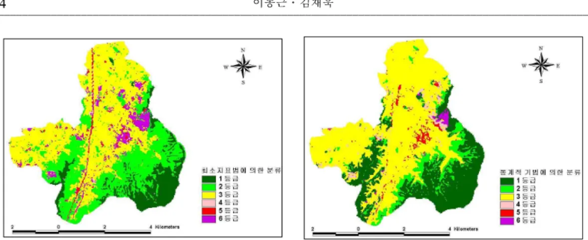
The overlay analysis results showed level 1 13.2%, level 2 30.7%, level 3 47.4%, level 4 1.0%, level 5 2.4%, level 6 5.4% and so on. The gravity matrix was classified as level 1 27.0%, level 2 9.3%, level 3 58.2%, level 4 2.4%, level 5 2.3%, level 6 0.9% and so on.
These results are more appropriate than current methods for plans that value the environment because the analyzed results of the gravity matrix have a tendency to highly condense the environmentally valuable area.
Consequently, if the spacial and environmental plans combine and therefore expand the efficient
use of the land in the current state where the nation's concern in environment is getting higher, it is thought that it will contribute highly on the development of the nation's life quality.
Key Words:Environment-oriented land suitability assessment, Cheonan city, Overlay Analysis, GIS, Gravity model.
Ⅰ. 서 론
최근 수도권을 중심으로 한 준농림지역의 무 질서한 개발이 인구급증과 환경훼손 등 여러 문 제점을 야기하면서 사회문제화 되고 있다. 개발 가능토지의 공급확대를 위해 도입된 준농림지 역은 주택공급과 공업시설의 입지난 해소에는 기여하였으나, 세수확대를 위한 지자체의 과도 한 개발과 이원화된 계획체계로 인한 관리부재 등으로 난개발이 이루어져 왔다. 난개발이란 무 계획적인 개발로 인해 녹지공간과 우량농지가 훼손될 뿐만 아니라 기반시설 및 공공시설 공급 부담의 가중, 토지이용의 효율성 저하 등을 초 래하는 개발행위를 의미한다. 이러한 정의 속에 는 난개발에 대한 해결책도 포함하고 있다. 즉, 개발가능지와 보전지역을 구분하여, 보전지역은 철저히 보전하고 개발가능지는 계획을 통한 개 발만 가능하도록 해야한다는 의미를 가지고 있 다(서순탁, 2000).
이처럼 개발시대의 관점에서 수립된 국토이 용 및 도시계획체제는 지역개발과 환경보전이 공존하는 새로운 시대를 맞이하여 수정이 필요 하다고 볼 수 있다. 2003년 1월부터 시행 중인
국토의계획및이용에관한법률에서는 선계획- 후개발 체제도입, 환경과 개발의 조화, 충분한 기반시설 및 기초생활시설 확보 등 비도시지역 의 난개발을 방지하기 위한 제도의 도입과 정비 에 힘쓰고 있다. 또한 토지이용을 계획적으로 관리함으로써 한정된 토지자원을 효율적으로 이용하고 보전할 수 있도록 토지적성평가를 도 입한 것도 같은 맥락으로 해석할 수 있다.
그러나, 토지적성평가는 현행 국토이용관리법 상 준도시지역과 준농림지역을 포함하는 관리 지역만을 세분화하기 때문에 적성평가를 실시 하지 않는 우선등급지역이 존재하고, 평가단위
가 필지단위이기 때문에 지표의 정확한 특성을 잘 반영하지 못하는 단점이 있다. 따라서 본 연 구에서는 환경적으로 보전가치가 높은 토지를 구분하여 환경친화적인 도시계획 수립이 가능 한 환경성평가를 이용하여 환경적 가치를 평가 하고자 한다(이재준․이상문, 2001; 이동근 등, 2004).
한편, 지역을 구분하기 위한 연구는 그동안 매 우 활발하게 진행되었다. GIS를 이용한 환경평 가 또는 지역유형 구분에 관한 최근 연구로는 국 내에서는 양하백(2001), 황국웅․엄붕훈(2003) 등이 있으며, 국외에서는 Lin(2000), Joerin and Musy(2000), Liu and Samal(2002), Kalogirou(2002) 등이 있다. 주성분 분석 등 통계적 기법을 이용 한 지역유형화 방법의 연구는 이종상(2002), 정 진현 등(2002), 장현웅․이명훈(2002), Dai et al.
(2001) 등이 있으나, 이러한 연구에서는 분류단 위가 행정구역이라는 한계를 가지고 있다. 행정 구역 단위로 유형구분이 이루어진다면 지역 내 의 토지가 갖는 각각의 특성을 반영하기가 어렵 기 때문에 본 연구에서는 토지를 Grid 단위로 구 분하여 토지의 특성을 계획에 반영하고자 한다.
또한 최소지표법과 중력모형을 이용한 분석을 상호비교하여 국토의 토지환경성평가를 일반화 시키기 위한 방향을 제시하는데 본 연구의 목적 이 있다.
Ⅱ. 연구범위 및 방법
1. 연구의 범위
본 연구의 목적을 달성하기 위해 설정한 연구 지역은 천안시 북부의 성거읍으로 선정하였다.
연구지역 선정이유는 수도권과 연접지역으로
서 수도권 전철의 연장으로 인한 인구집중과 편
리한 교통으로 인한 공업단지의 확대 등 개발 압
기 후
생 물 적
지 질 지 형 토 양 잠재자연식생
비 생 물 적
현 존 식 생 토 지 이 용 자연적측면
토지자연시스템 지역시스템
시간적 변화 인문적측면
공간적계층성