• 검색 결과가 없습니다.

Research of Vehicle Navigation Based Video-GIS

N/A
N/A
Protected

Academic year: 2021

Share "Research of Vehicle Navigation Based Video-GIS"

Copied!
6
0
0

로드 중.... (전체 텍스트 보기)

전체 글

(1)

Research of Vehicle Navigation Based Video-GIS

Jiang-Fan Feng * Guan-Yu Zhu ** Zhao-Hong Liu * Yan Li ***

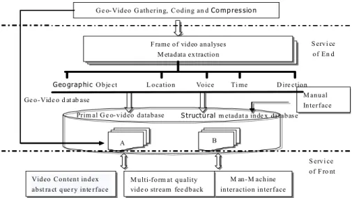
Abstract In order to make the effect of the navigation system more direct, the paper proposes a thought of vehicle navigation system based on Video-GIS. A semantic framework has been defined whose core is focused on the integration and interaction of video and spatial information, which supports full content retrieval based on multimodal metadata extraction and fusion, and supports kinds of wireless access mode. Furthermore, requirements of prototype system are discussed. Then the design and implementation of framework are discussed. Next, describe the key ideas and technologies involved.

Finally, we point out its future research trend.

Keywords : Video-GIS, Geo-Video, Video Database, Vehicle Navigation

󰠕

This research was supported by The National High-tech Research and Development Program(Project No.2007AA12Z238) of China.

**

Professor, College of Computer Science,Chongqing University of Posts &Telecom, {fengjf(corresponding author), liuzh}@cqupt.edu.cn

**

Master Student, College of Computer Science,Chongqing University of Posts &Telecom, [email protected]

***

Doctoral Student, Information Engineering Department, Inha University, [email protected] Manuscript received:2009.05.12 Revised:2009.06.18 Accepted:2009.06.20

1. Introduction

Intelligent Transportation System(ITS) has become the primary direction of traffic field while the vehicle navigation is the hot spot of research. The vehicle navigation is used to help driver choose optimal path, improve the efficiency, and provide road information in advance, such as road turning, accident-prone areas and so on. Nowadays, the technology of navi- gation system based electronic map which generally use arrow mark, eagle or voice prompt to conduct the road is mature relatively, but the 2D map is not con- ducive to judge for people because the road condition is reflected in abstract mode. The user can only ac- quire map information through visual sense, not to transfer multiple sense and locomotorium like real world. For example, when the information such as

"Turn right 150 meters in the front" is transmitted from the vehicle system to user, firstly the "turn right" information is casted light upon real point. It is usually different to judgment when move in the com- plicated region. Meanwhile, it is required certain driving experience to judgment the distance of "150 meters". Because of the restriction of time, the driver often judge mistakenly. One way to endure this prob- lem is use the 3D Virtual Simulation System, but it

is difficult to implement in current condition [1]. On one hand, the project is huge to build the 3D data- base with the real of texture of urban road and sur- rounding scene. On the other hand, it is difficult to implement wireless transmission of mass data based mobile terminal.

As one of the common media, video includes nu- merous information of geography and attribute itself.

The video can not only be easily acquired, but also express strong realistic Geo-spatial. While, in current GIS application, the whole segment video is accom- plished as same geographic object. Such as traffic monitor video, pollution source monitor video, multi- media electronic map and so on. In these applications, the information of video is not used entirely. In Video-GIS, each frame has its coordinate and ori- entation information which called geographic in- formation in it. It was achieved by coding. The sys- tem which utilized to manage and transmit videos with geographic information is called Video-GIS.

Using the geographic information contained in frame,

searching video segments or some frames in the sys-

tem becomes more effective. The Video-GIS endure

the deficiencies which include indirection of 2D GIS,

complexity of modeling for virtual reality system and

overlooking of aviation image and provide a more

(2)

M anual Interface

S ervi ce of En d F rame of video analyses

M etadata extraction

Geo grap hic O bje ct L ocation Voice Ti me D ire ction

S tructu ral m etadat a inde x dat abas e Prim al G e o-video database

B Ge o-Vide o d at ab ase

A

G e o-Video G athering, Coding an d Co mp res sio n

M an-M achine interaction interface Video Content index

abst ra ct que ry inte rface

S ervi ce of F ro nt M ulti-form at quality

vide o stream fee dback

Fig. 1. The Diagram of System Architecture

natural, real and timely surrounding of “watching world sidely” and “atching world flexiblely” for user based the sundry of video data acquisition and flexi- bility of modeling and analysis.

Video-GIS is the foundation of video navigation in this paper. The fundamental of vehicle navigation based Video-GIS is as followings: Under the founda- tion of existing vehicle navigation system based on the electronic map, establishing the Geo-Video data- base of road network and using the information of mobile terminal or fixed target to execute the spatial index for video database, then transport the video of relevant position to mobile terminal in order to realize guidance for route and goals. Thus, the effect of ve- hicle navigation is more real and intuitive.

The remainder of the paper is structured as follows. In the next section, the goal and architecture of system is introduced. Section 3 mainly introduces the key technologies. Section 4 presents the System Front-end.

And section 5 presents the conclusion of this paper and the future work.

2. The System Goal and Architecture

The goal of vehicle navigation based Video-GIS is establishing the distributed and open information storage center mainly saved Geo-Video. The center can store, manage and distribute the Geo-Video, pro- vide the video information service for vehicle navi-

gation, and permit user to access these contents and services through different networks and platforms without the Spatial-temporal restriction.The archi- tecture of system showed as the following Fig 1:

The Geo-Video itself doesn't hold out interaction between user and the system,the use of video is a unidirectional process. Though there are prolific un- developed contents and knowledge which are diffi- cult to manage systematically. These data should not search by key words directly. The efficacious man- agement of Geo-Video need to extract undeveloped contents and knowledge in vedio by automatic mode like library manage system and provide a tool like index to complete the work of video pigeonhole[3].

The constitution of Geo-Video media index is the core of system and video metadata is the foundation.

Metadata is used to describe the attribute and con-

tent of primal video source, structural information

which can be understood by computer. Though great

advance has been obtained in definition and ex-

traction of metadata, such as MPEG-7 multimedia

content description standard, essentially the algorithm

depending extraction of metadata are based on signal

analysis which are unable to adapt the widespread

application background. Due to the MPEG-7 standard,

the characteristic based vehicle navigation based

Video-GIS is formed after the description of MPEG-7

standard[4,5]. Through subjoining the index on the

Geo-information which including MPEG-7 data, the

user can index the information comfortably and the

(3)

GPS Receriver

MPEG4 Codion

Digital Camera

Real World Informa Geograph tion ic Video /Audi o Infor matio n

ASF Container

Video Information

Audio Information

Geographic Information

Fig. 2. Prototype of Video Encoder based ASF

information index of Geo-Video is more intelligent.

3. Key Technologies 3.1 Geo-Video data acquisition

The Geo-Video is acquired through Geo-Video coding technology. Under the nondestructive audio condition, the real Geo-Video streaming media is formed base on the quality of synchronization and automatic real-time integration between spatial loca- tion information and video information.

Considering the high compression ratio and low bits ratio, the flexible MPEG-4 video compression standard bethink of. ASF(Advanced Streaming Format) is a data format for streaming media which as a container to effectively organize images, videos, audios, control commands script and other multimedia information. This format not only support local stor- age but also can be transported as network packets.

Compare with other streaming media format, the ASF provide a method for synthesis and expression of media which is unrelated with any multimedia sys- tems, operating system and data communication protocol. Figure 2 shows the coding process.

The realization apply self-development Geo-video data collector (The structure showed as the Fig 3) and use Xscale PXA255(Its operating frequency is 520MZ) as master control chip. The system gathers the information of video and audio by camera inter- face while gathers the spatial location information by GPS module through RS232, then sends the data af- ter coding by GPRS/CDMA module through serial, saves the data.

Audio and Video Gathering

Xscale PXA255

GPS Data Buffer(FIFO)

Data Buffer(FIFO) RS232

GPRS/CDMA COM

Local Storage

Fig. 3. Framework of Device on Geo-video Acquisition

3.2 Video Excision

The basic unit of final effective video index is vid- eo segment. It has been completely discussed that the video excision is precondition of any execution for content management of digital video [6]. Based the current research foundation of video excision, this paper indicate that the spatial location information Inherent in video is the important basis of video ex- cision for Geo-Video. In order to improve the effi- ciency of video excision and probability of camera and spatial location information, multiple methods such as color, shape fuzzy edge histogram and match detection between spatial location information and road information are integrated to execute.

3.3 Video Data Model

The structure of metadata can be divided in two

parts. One is the Video head part ("Description

Metadata") which includes the basic information of

video, such as date, time, creator and so on. Another

is the data of every frame which include the in-

(4)

Fig.4 Interlace of Mobile Navigating System formation of abstract objects, such as 3D geography

coordinate, interactive image region, information of intersection, correlative URL [7] and so on. A part of example included Video MPEG-7 metadata showed as followings:

Table 1. An Example for MPEG-7 Metadata

<VideoSegment>

<MediaTime>

<MediaTimePoint>0</MediaTimePoint>

</MediaTime>

<TextAnnotation>

<FreeTextAnnotation>

<Where>118.9054, 32.1145</Where>

<Object>

<Region>125, 254, 254,12, 124, 123, 25, 125</Region>

<URL>http:// dky.njnu.edu.cn/</URL>

</Object>

</FreeTextAnnotation>

<KeywordAnnotation>

<Keyword></Keyword>

</KeywordAnnotation>

</TextAnnotation>

</VideoSegment>

3.4 Multimodal Geo-Video Feature Extraction

The Geo-Video data sets include four kinds:

• The different kinds of objective information about video data in external environment. This information includes time of video creation, length, format and some other indirect information about video in the system.

- Spatial location information of video frame.

- Annotation and sign edited by users.

- Metadata extracted by automatic video or audio analytic algorithm. It includes key frame, text, voice detection, notation and so on.

The emphasis illustrated in detail as followings:

Spatial location information: The spatial location in- formationincluded by Geo-Video frame which contain the important information nearly related to semantics.

Key frame: It is chosen from segment which has the major idea of the segment. The key frame was extracted for each segment to describe the main idea of the segment.

Audio segmentation and identification: The two- step method is used to detect sound in video. At first, the edge between sound and non-sound is detected. //Then we search for sound. After the two

steps, we adjust the parameters automatically to con- verse audio stream to text. Using text we also can support retrieval for spatial domain.

Denominate noumenon identification based on knowledge: The text flow based audio identification and multi-modal metadata can extract geographic character by virtue of the denominate noumenon of related user-defined field.

4. System Front-end

The front-end program can be divided into three function interfaces (index, playback and information visual interface which supported interaction and con- tent related). The users can determine the line from the current location of vehicle to any destination in the network by driving line planning or execute in- dexing the video of geography objective which has been located. The result of index not only can show the usual map but also transmit relational video.

The user can execute these interactional operations when the video is broadcasting.

• Generate the shortest path by input the destina- tion through audio and broadcast relational video according to the situation of vehicle's move- ment.

• Turn on the relational network station of geog- raphy objective which has hyperlink on the video.

• Hit the interactional geography objective on the video(such as the red region in Fig 4) while the map show the location of objective synchronously.

The users' inquiry was transformed into query op-

(5)

eration for multi-modal metadata index based time related. The result was exchanged with foreground by standard XML. The exchange between metadata generated by the analytical framework of video media and database also apply the XML standard which is unrelated with platform and application.

5. Conclusions and Outlook

The vehicle navigation based Geo-Video not only can be used to effectively manage and dynamically distribute Geo-Video but also is able to transform the Geo-Video into fully indexed data type by extracting multi-modal metadata. The function of above process is used for video pigeonholing and whole content in- dex of friendly Human-Computer-Interaction mode and provides more easily understandable expression of navigation information for users.

The Geo-video coding, metadata based XML switching and more convenient Human-Computer- Interaction are the crucial questions of Vehicle Navigation Based Video-GIS. The next research di- rection include as followings:

• Consummate the Geo-video coding machine to improve the efficiency of coding. It is expected to dispose the coding environment on PDA with the improvement performance of PDA.

• In connection with the different fields of content description, a unified descriptive criterion for sundry multimedia metadata was rendered by MPEG-7 multimedia content description stand- ard. The future progress is going to research on metadata exchange based MPEG-7 standard to further improve the open degree and implement Synchronization based standard with relational system [8].

• The graphical user interface in mobile environ- ment is inconvenient while voice interaction ob- tained widespread attention. The future progress need to research how to make use of Chinese speech to execute interaction with Video-GIS.

The purpose of research is further improve the integrated level between natural language and spatial language which is the kernel of geo- graphic information.

References

[1] LIU Yue-feng,ZHANG Jie,SUN Hua-bo,

“Research on Design and Key Technologies of Vehicle Navigation System Based On Geo- video,” In Geography and Geo-Information Science. September.2007

[2] Howard D.Wactlar, M.G.Christel, Y.Gong, A.

G.Hauptmann, “Lessons learned from building a Terabyte digital video library,” In IEEE Computer, 1999.42(2):66-73.

[3] Nigel D, Keith C, Keith M, Alon E, “Using and Determining Location in a Context-Sensitive Tour Guide,” In IEEE Computer, 2001, 34(8):

35-41.

[4] Hwang, T. H, “MPEG-7 Metadata for Video- Based GIS Applications,” In IGARSS 2003.

[5] Toni Navarrete and Josep Blat, “VideoGIS:

Segmenting and indexing video based on geographic information,” In AGILE Conference on Geographic Information Science, 2002.

[6] M.Bertini, A.Del Bimbo, P.Pala, “Content-based indexing and retrieval of TV new,” In Pattern Recognition Letters. 2001. 22(5):503-516.

[7] R.M.Bolle, B.L.Yeo.Yeung, “Video query:

Research directions,” In IBM Journal of Research and Development, 1998, 42(2):233-252.

[8] Christian Larouche, Clude Laflamme, Richard Levesque, “Georeferenced Aerial Videography in Erosion Monitoring,” In The Worldwide Magazine for Geomatics, September. 2002.

Feng Jiangfan

1998~2002 Southwest Agricultural University(B.S.)

2002~2007 Nanjing Normal University (Ph.D.)

2007~Present Associate Professor, Chongqing University of Posts and Telecommunications

Research Interests:Spatial Information Integration and

Multimedia Geographical Information System.

(6)

Zhu Guanyu

2002~2006 People's Liberation Army Information Engineering College (B.S.)

2006~2007 Shangqiu Normal College 2007~Present Maseter Student, Chongqing University of Posts and Telecommunications

Research Interests : Space Location Technology and Geographical Information System

Liu Zhaohong

1993~1997 Electronic Science and Technology University(B.S.) 1997~2001 Inha University(M.S.) 1997~Present Chongqing University of Posts and Telecommunications Research Interests : Spatial Database

Li Yan

2002~2006 Chongqing University of Posts and Telecommunications (B.S.)

2006~2008 Information Engineering Department, Inha University(M.S.) 2008~Present Doctoral Student, Information Engineering Department

Research Interests: Spatial Database, Spatial Data

Warehouse, GIS, USN, Stream Database System

수치

Fig.  1.  The  Diagram  of  System  Architecture
Fig.  2.  Prototype  of  Video  Encoder  based  ASF
Table  1.  An  Example  for  MPEG-7  Metadata

참조

관련 문서

It considers the energy use of the different components that are involved in the distribution and viewing of video content: data centres and content delivery networks

1 John Owen, Justification by Faith Alone, in The Works of John Owen, ed. John Bolt, trans. Scott Clark, &#34;Do This and Live: Christ's Active Obedience as the

So, we proposed a novel method for video event analysis and description on the fundamental of the Domain Knowledge object ontology, the MPEG-7 standard is extended

Intraoperative photograph shows grossly total removal of tumor using the navigation system

The results obtained from this paper will provide important physical properties of opto-electronic devices based on two dimensional materials, and will be

Based on the result of such assessment, this study attempted to establish a basis for establishment of physical epidemiology research evaluation system

Among these, research about unmanned aerial vehicle to perform the mission on behalf of the human has been developed in environment at difficult to reach

See: Masoumi and Meybodi, Learning automata based multi-agent system algorithms for finding optimal policies in Markov games (2012) and Unsal, Cem, Intelligent Navigation