• 검색 결과가 없습니다.

Improvement of COMS Land Surface Temperature Retrieval Algorithm

N/A
N/A
Protected

Academic year: 2021

Share "Improvement of COMS Land Surface Temperature Retrieval Algorithm"

Copied!
9
0
0

로드 중.... (전체 텍스트 보기)

전체 글

(1)

1. Introduction

KMA (Korea Meteorological Administration) has been developing the COMS (Communication, Ocean and Meteorological Satellite) meteorological data processing system (CMDPS) for the successful operation and efficient use of the satellite data (e.g., KMA, 2008). The COMS is the first geostationary multipurpose satellite of Korea, which will be

launched at the early of 2010. Various meteorological variables, such as clouds, aerosol, sea surface temperature and land surface temperature (LST) will be derived automatically by the CMDPS from the COMS level-1b data. LST is a key environmental variable in a wide range of applications, such as weather, climate, hydrology, and ecology (Prata and Cechet, 1999). However, LST is one of the most difficult surface variables to observe regularly due to

Improvement of COMS Land Surface Temperature Retrieval Algorithm

Ki-Ok Hong, Myoung-Seok Suh

, and Jeon-Ho Kang

Department of Atmospheric Science, Kongju National University, 182 Shinkwan-dong, Gongju-city 314-701, Chung Cheongnam-do, Korea

Abstract : Land surface temperature (LST) is a key environmental variable in a wide range of applications, such as weather, climate, hydrology, and ecology. However, LST is one of the most difficult surface variables to observe regularly due to the strong spatio-temporal variations. So, we have developed the LST retrieval algorithm from COMS (Communication, Ocean and Meteorological Satellite) data through the radiative transfer simulations under various atmospheric profiles (TIGR data), satellite zenith angle (SZA), spectral emissivity, and surface lapse rate conditions using MODTRAN 4. However, the LST retrieval algorithm has a tendency to overestimate and underestimate the LST for surface inversion and superadiabatic conditions, respectively. To minimize the overestimation and underestimation of LST, we also developed day/night LST algorithms separately based on the surface lapse rate (local time) and recalculated the final LST by using the weighted sum of day/night LST. The analysis results showed that the quality of weighted LST of day/night algorithms is greatly improved compared to that of LST estimated by original algorithm regardless of the surface lapse rate, spectral emissivity difference (De) SZA, and atmospheric conditions. In general, the improvements are greatest when the surface lapse rate and De are negatively large (strong inversion conditions and less vegetated surface).

Key Words : Land surface temperature, COMS, MODTRAN 4, day/night algorithms.

Received December 1, 2009; Revised December 22, 2009; Accepted December 24, 2009.

Corresponding Author: Myoung-Seok Suh ([email protected])

(2)

the strong spatio-temporal variations. At present, instruments on board satellites working in the thermal infrared are the only available operational systems capable of collecting cost-effective LST data at spatial and temporal resolutions appropriate to modeling applications (Becker and Li, 1995; Peres and DaCamara, 2004).

Theoretical possibility for the retrieval of LST using split-window method has been shown by Becker and Li (1990), and many others. Numerous works have been made to retrieve the LST from the satellite data, especially polar orbit satellite (NOAA/AVHRR, Terra/MODIS, Landsat/TM) (e.g., Price, 1984; Kerr et al., 1992; Ulivieri et al., 1994;

Wan and Dozier, 1996; Han et al., 2004; Suh et al., 2008). However, operational retrieval of LST from the satellite data is very limited due to the poor accuracy of retrieved LST, particularly using geostationary satellite. The lower quality of retrieved LST is mainly caused by the combined effects of spatially and temporally varying emissivity and atmospheric conditions (Ulivieri et al., 1994; Jiang et al., 2006).

Recently, the various background data (e.g., land cover, vegetation index) and methods (vegetation coverage method; Valor and Caselles, 1996;

Loveland et al., 2000) for the estimation of spectral emissivity are developed. And the quality of geostationary satellite (e.g., MSG/SEVIRI, MTSAT- 1R) has been greatly improved recently. As a result, the quality of LST retrieved from geostationary satellite data, such as MSG/SEVIRI, has been significantly improved. As in the MODIS LST group, the LST over Africa and Europe retrieved operationally by the EUMETSAT LSA/SAF (Land Surface Analysis Science Application Facility) (Peres and DaCamara, 2004; Sobrino and Romagura, 2004).

Hong et al. (2009) developed a split-window type LST algorithm by using MTSAT-1R data and

evaluated the performance of LST algorithm using MODIS LST data. They showed that the LST over East Asia can be retrieved from MTSAT-1R data with the correlation coefficients and RMSE of about 0.82~0.99 and 1.5~4.28 K, respectively. However, the quality of retrieved LST is significantly better at nighttime than at the daytime and in vegetated areas rather than barren areas.

Basic information including spectral response functions and sub-satellite point of the COMS are released at the end of 2008. In this study, we developed LST retrieval algorithm using COMS data and evaluated the sensitivity of LST retrieval algorithm to the various impacting factors. And we developed 3-set (total, day and night LST algorithms) of split-window type LST retrieval algorithms to improve the quality of estimated LST from COMS data.

2. Radiative transfer model simulation

To develop a LST retrieve algorithm using a split- window method, ground match-up data are needed for the coefficients of regression equation. However, unlike the sea surface temperature, available match- up data over East Asia are severely limited in LST.

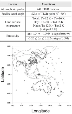
So, we performed radiative transfer model simulations using MODTRAN 4 with various atmospheric and satellite viewing conditions. The main factors affecting the retrieved LST using split- window method are atmospheric profiles, spectral emissivity, satellite zenith angle and lapse rate at surface layer. The radiative transfer simulations are designed to include all the impacting factors (Table 1).

In order to consider the atmospheric effects, 441 TIGR databases were used within 60˚ of satellite zenith angle from the COMS position (see Fig. 1).

LST has been subscribed to consider the strong

(3)

diurnal variation, from Ta -12 K to Ta +16 K in steps of 2 K. Here, Ta is air temperature of the lowest layer in the TIGR data. The total range of LST is separated into two overlapping sub-ranges Ta-12 K to Ta +2 K and Ta -2 K to Ta +16 K. The former and latter sub- ranges would most likely represent nighttime conditions and daytime conditions, respectively. And the spectral emissivity of IR1 is prescribed from 0.9478 to 0.9968 in steps of 0.0014 and the emissivity difference between IR1 and IR2 is also prescribed from -0.02 to 0.012 in steps of 0.004. As a result, the number of total simulation is 441 (profiles) × 15 (surface lapse rate) × 11 (emissivity) × 9 (emissivity difference) = 654,885.

3. Development of LST algorithm

1) Development of 3 sets of LST algorithms Brightness temperatures are produced using the radiances generated through RTM simulations and COMS spectral response function using inverse Planck equation. The LST retrieval algorithm has been developed by using a statistical regression method in the form of Eq. (1).

LST = a + bT

IR1

+ cDT + dDT

2

+ e(secq

_

1) + f(1

_

_

e) + gDe (1)

Where T

IR1

is brightness temperature of IR1 and q is satellite zenith angle. DT = T

IR1_

T

IR2

, _

e = , and De = e

IR1_

e

IR2

.

At first, we developed the LST retrieval algorithm (Tot_LST) by using the total simulation data set as in Hong et al. (2009). And we also developed day/night LST algorithms (Day_LST, Ngt_LST) separately by using the different simulated data set under the day and night conditions (Table 1). The impacting conditions in the day/night time simulations are same as in the total simulations except for the surface lapse rate conditions. The derived coefficients for the three sets of LST algorithms are in Table 2.

2) Combined use of day/night LST algorithms To minimize the LST inconsistency at the boundary time and/or region caused by the two e

IR1

+ e

IR2

2 Table 1. Atmospheric and sensor-target conditions used in

RTM simulations

Factors Conditions

Atmospheric profile 441 TIGR database Satellite zenith angle SZA of TIGR point (0˚~60˚)

Total : Ta-12 K ~ Ta+16 K Land surface Day : Ta-2 K ~ Ta+16 K

temperature Night: Ta-12 K ~ Ta+2 K (a step of 2 K)

Emissivity IR1: 0.9478 ~ 0.9968 (a step of 0.0049) -0.02 ≤ De ≤ 0.012 (a step of 0.004)

Factors Conditions

Fig. 1. Spatial distribution of TIGR data used in this study. The location of COMS is represented by ‘ ’.

Table 2. Coefficients for the three sets of LST retrieval algorithm

Total Day Night

a 23.5257 23.4199 21.1551

b 0.908397 0.909795 0.919133

c 2.04278 1.88002 1.89691

d 0.156848 0.167650 0.127217

e 0.40709 1.05469 -0.56263

f 54.3323 58.0366 47.1721

g -111.239 -120.104 -86.5485

Total Day Night

(4)

different LST algorithms (day/night algorithms), the final LST is recalculated by using the weighted sum of two LST estimated separately by the day and the night LST algorithms. The weighted sum of two LST is performed using Eq. (2)

LST_Wgt = w×NA_LST + (1

_

w)×DA_LST (2) The NA_LST and DA_LST represent the LST retrieved by the nighttime LST algorithm and by the daytime LST algorithm, respectively. And w is the weighting value as a function of the temperature difference between Ts and Ta. If the difference between Ts and Ta is smaller than -6 K, w is 1.0 because it can be regarded as a nighttime condition.

In contrast when DT is large than +6 K, w is 0.0 since it can be regarded as daytime condition. If DT is between -6 K and +6 K, w changes from 0.0 and 1.0 as a function of DT (Eq. (3)).

w =

_

×DT + (3)

w

max

= 1.0 (Ts

_

Ta

_

6K) w

min

= 0.0 (Ts

_

Ta ≥ +6K)

After COMS launched, local solar zenith angle will be used, instead of DT, in the calculation of w for operational LST retrieval from COMS data.

3) Performance test

The performance of two LST algorithms, total and weighted sum of day/night algorithms, are investigated. The quality of retrieved LST is influenced by many factors such as atmospheric profiles (brightness temperature difference: BTD), De, lapse rate at surface layer (Ts - Ta), satellite zenith angle, and more. To evaluate the relative performance of the two LST algorithms, bias and RMSE of two LST algorithms (total: Tot and weighted sum: Wgt) for the various conditions were compared.

The distribution of biases of two LST algorithms, the difference between prescribed LST and estimated LST, are shown in Fig. 2. The distribution of biases of two LST algorithms is very similar (Fig. 2). The majority of biases are ranged from -3 K and +3 K.

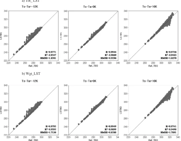
Fig. 3 shows a scatter plot of the retrieved LST (LST) by the two types of algorithms and prescribed LST (Ref_T) according to the surface lapse-rate. The figures show that two LST algorithms estimate LST very reasonably when the surface lapse rate is neutral.

Compared to the Tot_LST, the Wgt_LST is clearly improved for the various conditions (RMSE was improved by 0.14 K (1.85 → 1.71), 0.042 K (0.929

→ 0.858), and 0.04 K (1.82 → 1.78) when Ts-Ta is - 12 K, 0 K, and +16 K). The improvement is more significant at nighttime than daytime.

Fig. 4 shows biases of two LST algorithms according to DT. In total algorithm, the biases range from -0.45 to +1.18. Compared to the biases of Tot_LST, the biases of Wgt_LST are clearly reduced regardless of the surface lapse rates. However, the two LST algorithms overestimate and under estimate the LST for the strong inversion and superadiabatic conditions, respectively.

Fig. 5 shows RMSE and difference of RMSE between two LST algorithms according to the DT.

Two bars represent the RMSE of two algorithms and the line is difference between two LSTs. The 1

12 1

12

Fig. 2. Distribution of biases of two LST algorithms (left: Tot,

right: Wgt).

(5)

numbers in the circle are improvement rate of Wgt_LST compared to the Tot_LST. RMSE of Tot_LST algorithm is clearly dependent on the surface lapse rate condition, small at the neutral

conditions and large in the strong inversion and adiabatic conditions. The RMSE is significantly decreased in the Wgt_LST, especially at the strong Fig. 3. Scatter plots of retrieved LST (ordinate; LST) and prescribed LST (abscissa; Ref_T) according to the surface lapse rate.

b) Wgt_LST a) Tot_ LST

Fig. 4. Biases of two LST algorithms according to the surface

lapse rate. Fig. 5. Distribution of RMSE and the improvement ratio in

Wgt_LST algorithm according to the surface lapse rate.

(6)

inversion conditions (5.4% ~ 9.0%).

The RMSE of two LSTs are function of absolute value of De (Fig. 6). The performance of the Wgt_LST is also improved regardless of De. The maximum and minimum improvement rates are 9.02% and 1.18% when De are -0.02 and +0.012, respectively. The improvement rate (bars) is more significant when De is negatively large. This is caused by strong reduction of atmospheric effects as a result of large negative emissivity difference (larger increase of T5 than T4 resulted in the decrease of DT).

Generally, the retrieved LST is influenced by satellite zenith angle (Fig. 7). In Fig. 7, the bars, black, grey and dotted lines represent the number of

TIGR data sets, RMSE of Tot_LST and Wgt_LST, and improvement ratio in Wgt_LST, respectively.

The RMSE of LST increased as the satellite zenith angle increases regardless of the retrieval algorithms.

This is due to the combined effects of increased optical path length and deviation from the standard weighting functions of IR1 and IR2. The relatively large RMSE for small satellite zenith angle is related to the small number of TIGR data sets and their coastal location. The number of TIGR stations is zero at the 0˚ ~ 10˚, only four and one at 5˚ ~ 10˚ and 10˚

~ 15˚, respectively.

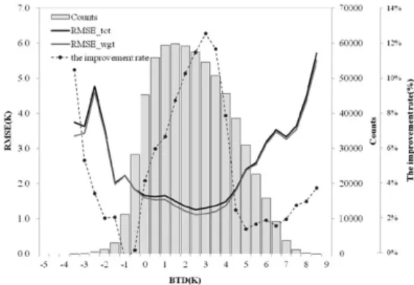
Fig. 8 shows the distribution of RMSE and improvement ratio in Wgt_LST according to the BTD as in Fig. 7. The performances of two LST algorithms are much better at small BTD than at large BTD. The BTD ranges from -4 K to +9 K, most of them are located in -1 K to +6 K. The negative and large positive BTD are caused by the large negative emissivity differences and large amount of water vapour, respectively. The improvement in the Wgt_LST is largest at the small BTD. It means that the impact of surface lapse rate is relatively small when BTD is large. However, the RMSE is significantly large and improvement is small when the BTD is large. The large RMSE can be caused by the nonlinear term, DT

2

, in retrieval algorithm (Eq.

Fig. 6. Distribution of RMSE and the improvement ratio in Wgt_LST algorithm according to the De.

Fig. 7. Distribution of RMSE and the improvement ratio in Wgt_LST algorithm according to the SZA with the number of TIGR data.

Fig. 8. Distribution of RMSE and the improvement ratio in

Wgt_LST algorithm according to the BTD with the

number of BTD data.

(7)

(1)), over consideration of water vapour impact.

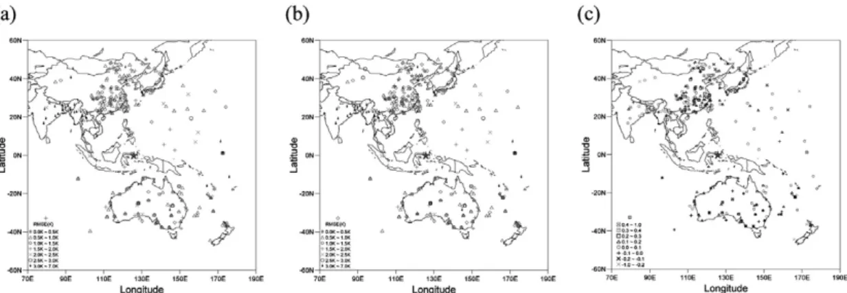
Fig. 9 shows the spatial distribution of RMSE and the improvement ratio in Wgt_LST at the each TIGR data points. RMSE is less than 2.5K at the most of TIGR stations, but larger than 3K is found at some TIGR stations. The accuracy of Wgt_LST is improved by 45%, even in stations where error is large. However, the improvement rate is negative (means that the quality of LST is deteriorated) in some station, especially the RMSE of Tot_LST is small. The causes for the negative impacts are underway.

4. Summary

In this study, we have developed the LST retrieval algorithm from COMS data through the radiative transfer simulations under various atmospheric profiles (TIGR data), satellite zenith angle (SZA), spectral emissivity, and surface lapse rate conditions using MODTRAN 4. To improve the quality of estimated LST, we developed daytime and nighttime LST algorithms separately by using the different match-up data base according to the surface lapse rate conditions. The final LST (Wgt_LST) is recalculated using weighting method of the two LST (Day_LST

and Ngt_LST) to minimize the inconsistency at the boundary time and/or region of day and night conditions.

In general, the two LST algorithms (Tot_LST and Wgt_LST) reproduced the LST reasonably for the various atmospheric and surface conditions. The improvements in Wgt_LST are positively consistent regardless of the impacting conditions although the improvements in Wgt_LST are quite different according to the atmospheric and surface lapse rate conditions. The impacts are largest for the large negative in Ta - LST (strong inversion conditions) and large negative De. And the improvements in Wgt_LST are very consistent without regard to the satellite zenith angle. The improvement in Wgt_LST is more significant for the small BTD than large BTD.

The results showed that the quality of LST

estimated from the COMS data can be greatly

improved compared to the Tot_LST by using the

weighted sum of day and night LST. However, the

RMSE of Wgt_LST is also significantly large and

improvement is small when the BTD is large and

superadiabatic conditions. The large RMSE can be

caused by the nonlinear term, DT

2

, in retrieval

algorithm (Eq. (1)), over consideration of water

vapour impact. It indicates that some modification is

Fig. 9. Spatial distribution of RMSE, (a) Tot_LST and (b) Wgt_LST, and (c) improvement ratio in Wgt_LST.

(8)

needed to minimize the non-linear term in Eq. (1)

Acknowledgements

This research was supported by the Korea Meteorological Administration Research and Development Program under Grant CATER 2009- 3114.

References

Becker, F., and Z. L. Li, 1990. Toward a local split window method over land surface, International Journal of Remote Sensing, 3:

369-393.

Becker, F., and Li, Z.-L., 1995. Surface temperature and emissivity at various scales: Definition, measurement and related problems, Remote Sensing Reviews, 12: 225-253.

Han, K. -S., A. A. Viau, and F. Anctil, 2004. An analysis of GOES and NOAA derived land surface temperatures estimated over a boreal forest, International Journal of Remote Sensing, 25: 4761-4780.

Hong, K. O., M. S. Suh, and J. H. Kang, 2009.

Development of a Land Surface Temperature- retrieval Algorithm from MTSAT-1R data, Asia-Pacific Journal of Atmospheric Sciences, 45(3): 412-421.

Jiang, J-M., Li Z-L., and F. Nerry, 2006. Land surface emissivity retrieval from combined mid-infrared and thermal infrared data of MSG-SEVIRI, Remote Sensing of the Environment, 105: 326-340.

Kerr, Y. H., J. P. Lagouarde, and J. Imbernon, 1992.

Accurate land surface temperature retrieval from AVHRR data with use of an improved

split window, Remote Sensing of the Environment, 41: 197-209.

KMA, 2008. Development of Meteorological Data Processing Systems of Communication, Ocean and Meteorological Satellite (V), 953pp.

Loveland, T. R., Reed, B. C., Brown, J. F., Ohlen, D.

O., Zhu, Z., Yang, L., and Merchant, J. W., 2000. Development of a global land cover characteristics data base and IGBP DISCover from 1 km AVHRR data, International Journal of Remote Sensing, 21: 1251-1277.

Peres L., and C. C. DaCamara, 2004. Land surface temperature and emissivity estimation based on the two-temperature method: sensitivity analysis using simulated MSG/SEVIRI data, Remote Sensing of the Environment, 91: 377- 389.

Prata, A. J., and R. P. Cechet, 1999. An assessment of the accuracy of land surface temperature determination from the GMS-5 VISSR, Remote Sensing of the Environment, 67: 1-14.

Price, J. C., 1984. Land surface temperature measurements from the split-window channels of the NOAA 7 AVHRR, Journal of Geophysical Research, 89: 7231-7237.

Sobrino, J. A., and M. Romaguera, 2004. Land surface temperature retrieval from MSG1- SEVIRI data, Remote Sensing of the Environment, 92: 247-254.

Suh, M.-S., S.-H. Kim, J.-H. Kang, 2008. A comparative study of algorithms for estimating land surface temperature from MODIS data, Korean Journal of Remote Sensing, 24: 65-78

Ulivieri, C., M. M. Castronouvo, R. Francioni, and A.

Cardillo, 1994. A split-window algorithm for

estimating land surface temperature from

satellites, Advances in Space Research, 14:

(9)

59-65.

Valor, E., and V. Caselles, 1996. Mapping land surface emissivity from NDVI: Application to European, African, and South American areas, Remote Sensing of the Environment, 57: 164-184.

Wan Z., and J. Dozier, 1996. A generalized split-

window algorithm for retrieval of land surface

temperature from space, IEEE Transactions

on Geoscience and Remote Sensing, 34: 892-

905.

수치

Fig. 1.  Spatial distribution of TIGR data used in this study. The location of COMS is represented by ‘ ’.
Fig. 3 shows a scatter plot of the retrieved LST (LST) by the two types of algorithms and prescribed LST (Ref_T) according to the surface lapse-rate
Fig. 4.  Biases of two LST algorithms according to the surface
Fig. 6.  Distribution of RMSE and the improvement ratio in Wgt_LST algorithm according to the De.
+2

참조

관련 문서

요약 : 천리안 위성 (Communication, Ocean and Meteorological Satellite, COMS)의 에어로솔 광학두께(Aerosol Optical Depth; AOD) 산출물의 검증을 위하여, 동아시아

본 연구에서는 국내 최초의 정지궤도위성인 Communication, Ocean and Meteorological Satellite (COMS)에서 산출된 정규식생지수의 적용성을 판단하기 위해 Maximum

This study developed a new algorithm of extreme rainfall extraction based on the Communication, Ocean and Meteorological Satellite (COMS) and the Tropical Rainfall Measurement

The GK2A Satellite is the next generation geostationary meteorological satellite that takes over the meteorological role of COMS (Communication, Ocean

COMS satellite is a multipurpose satellite in the geostationary orbit, which accommodates multiple payloads of the Ka band Satellite Communication Payload, Meteorological Imager,

Abstract This study provides a comparative analysis of cloud top heights observed by a Ka-band cloud radar and the Communication, Ocean and Meteorological Satellite (COMS)

In this study, finer resolution Land Surface Temperature (LST) was downscaled from 4 km to 500 m by combining GOCI with MI data of Communication, Ocean and Meteorological

In this study, we developed the LST retrieval algorithms from MTSAT-1R data through the radiative transfer simulations under various atmospheric profile (TIGR data), SVA and