낙동강 하구 연안사주섬의 현존식생 및 식생구조 연구 1
이율경2⋅안경환3*
Actual Vegetation and Vegetation Structure at the Coastal Sand Bars in the Nakdong Estuary, South Korea
1Youl-Kyong Lee
2, Kyung-Hwan Ahn
3*요 약
본 연구는 낙동강 하구역 연안 사주섬 식생의 발달과 분포 특성을 규명하고자 시행하였다. 총 118개의 식생자료를 획득되었다. 좌표결정법에 의해 식물종과 환경요소들 간의 관계를 규명하였으며, 이를 위해 RIM 등의 프로그램을 이용하였다. 총 12개의 식물군락이 구분되었으며, 건생형과 습생형으로 대분류 되었다. 이들 식물군락은 사주와 염습지 를 대표하는 하는 식생형으로 건생형은 해송군락, 순비기나무군락, 좀보리사초군락, 띠군락, 물억새군락, 갯메꽃군락, 습생형은 개수양버들-산조풀군락, 갈대-산조풀군락, 쇠보리-갈대군락, 갈대군락, 새섬매자기군락, 나문재-칠면초군락 등으로 구분되었다. 공간적으로 건생형 초본과 염습지의 갈대군락 및 새섬매자기군락이 가장 넓게 분포하고 있었다.
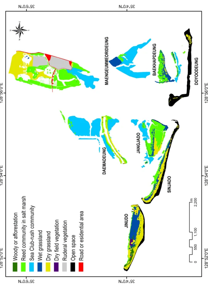
해안 사주의 대부분은 갈대군락이 대상으로 분포하며, 해안가에서는 새섬매자기군락이 관찰되었다. 현존식생도에서 가장 넓은 면적을 구성하는 식생유형은 새섬매자기군락, 염습지 갈대군락, 건생초원식생이다. 대부분의 사주섬 가장자 리에는 염습지 갈대군락이 대상으로 분포하며, 그 외곽에 새섬매자기군락이 발달하고 있다. 해안 사구식생과 염습지 식생은 각각 말단사주섬의 전방과 후방 지역에 분포하였다.
주요어: 갈대, 사구, 식생도, 염습지
1 접수 2012년 2월 20일, 수정(1차: 2012년 11월 2일, 2차: 2012년 12월 10일), 게재확정 2012년 12월 11일
Received 20 February 2012; Revised(1st: 2 November 2012, 2nd: 10 December 2012); Accepted 11 December 2012 2 참생태연구소 Cham Ecology Institute, Gangmyung, Soha-dong 1345, Gwangmyeong-si, Gyeonggi-do, Korea(423-795)([email protected]) 3 국립환경과학원 Environmental Research Complex, Gyeongseo-dong, Seo-gu, Incheon, Korea(404-708)([email protected])
* 교신저자 Corresponding author([email protected])
ABSTRACT
This study aim that definite the relationship between coastal environment and different sand bar communities, as well as to analyze their spatial distribution of barrier island in the Nakdong river estuary. Survey method follow by Braun-Blanquet(1965) and there a total of 118 relevé´s were undertaken. Definition of the relationships between species and environmental variables with Canonical Correlation Analysis(CCoA) and that to applied these relevé´s with the RIM(Kim and Kim, 2006) program and that to classification used the SYN-TAX 2000 program(Podani 1979). On the basis of about 118 phytosociological releve´s, the vegetation of xeric and hydric type was arranged in twelve plant communities: Xeric type-Pinus thunbergii community,Vitex rotundifolia community, Carex pumila community, Imperata cylindrica var. koenigii community, Miscanthus sacchariflorus community and Calystegia soldanella community, Hydric type-Salix
dependens-Calamagrostis epigeios community, Calamagrostis epigeios-Phragmites communis community,
Phragmites communis-Ischaemum aristatum community, Phragmites communis community, Scirpus planiculmis community and Suaeda glauca-S. japonica community.These plant communities represents sand
dune vegetation and salt marsh vegetation. Widely distributing types in the actual vegetation map were sea club-rush community, reed community in salt marsh, and dry grassland. The edge in the coastal sand bars has zonation that almost distribution by the reed community in salt marsh. But outside of it were distributed sea club-rush community. Dry grassland type distributes higher zone of the center in coastal sand bars.Respectively, the coastal sand dune and salt marsh vegetation types were distributed ocean and inland on the frontier of it.
KEY WORDS: REED, SAND DUNE, VEGETATION MAP, SALT MARSH
서 론
하구(estuary)는 생산성이 높으며(Reid and Wood, 1976), 생물다양성이 매우 풍부한 생태계 가운데 하나로 세계적으 로 보전 가치가 높게 평가된다(Costanza et al., 1997). 한반 도 내에서 남해와 서해로 유출되는 하천의 하구는 매우 낮 은 하상구배로 인해 상류로부터 운반되어 온 다량의 퇴적물 이 쌓여 사주(sand bar)가 쉽게 발달하는 조건을 가진다 (Kim, 2005). 이로 인해 하천퇴적물과 조류(潮流), 파도에 의한 연안사주섬의 발달과 쇠퇴가 매우 역동적이다(Kim, 2005). 특히 낙동강 하구에서 연안사주섬의 지형 변화는 하 구둑 건설(1987년 공사 완료) 이후 역동적이며(Kim, 2005), 이러한 물리적 환경에 대응하여 식물사회가 발달하거나, 쇠 퇴하고 있다.
하구에 발달하는 식물사회는 해안저서생물과 더불어 철 새의 중요한 서식 또는 먹이자원이 된다. 이로 인해 하구식 생은 높은 가치로 평가받고 있다(Hong, 2004). 낙동강 하구 는 세계적 철새 도래지로서 생태적 가치가 높아 국가에서 천연기념물(1966년), 생태계보전지역(1989년), 습지보호지 역(1999년) 등으로 보호 관리되고 있다.
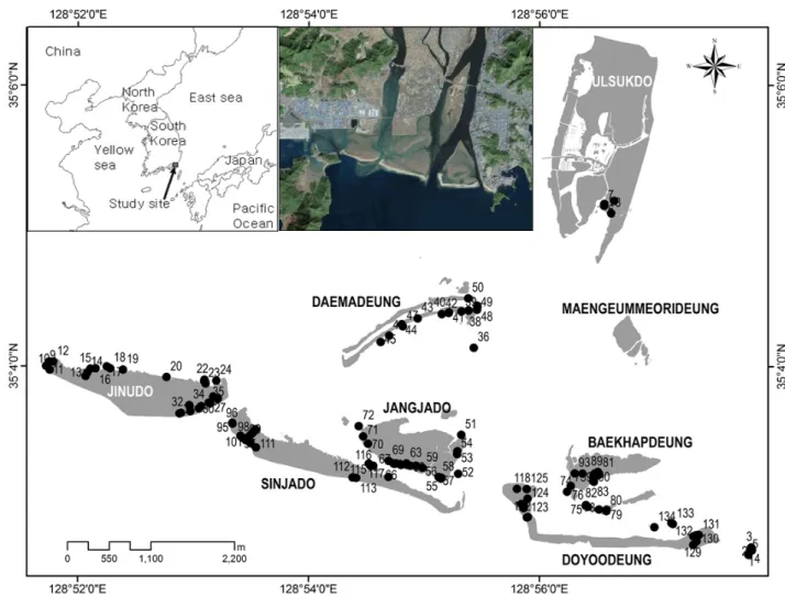
낙동강은 북에서 남으로 흐르는 남한 최장(유로연장 510
㎞; MLTM, 2008)의 국가하천으로 하구는 한반도 남동단 의 부산시 사하구에 위치하며, 넓은 염습지와 여러 사주섬 이 존재한다. 사주섬 가운데 을숙도는 하천작용에 의해 형 성된 하천사주섬이며, 진우도, 신자도, 장자도, 대마등, 도요 등, 백합등, 맹금머리등은 조류와 파도에 의해 형성된 연안 사주섬이다(Figure 2). 을숙도, 진우도, 대마등은 1916년 이 전에 형성된 섬이며, 도요등(1990 이전)과 신자도(1970 이 전)는 최근에 형성된 섬이다(Oh, 1999). 이들 섬은 역동적 으로 변화하고 있으며(Yi et al., 1999; Kim, 2005), 최근에 는 사주의 퇴적물들이 동향의 다대포 쪽으로 이동하는 것으 로 예측되고 있다(Lee and Kim, 2002). 맹금머리등과 을숙 도는 과거 서로 연결되어 있었으나, 하구둑 건설 이후 간석
지 일부가 수로로 준설되면서 분리되었다(Hong, 2004). 대 마등은 파밭으로 이용되었으나 1997년에 현재의 모양으로 복원되었다. 진우도는 사라호 태풍(1959년) 이후 무인도가 되었으며, 경작은 현재에도 부분적으로 이루어지고 있다.
장자도 역시 1990년대 초반까지 경작이 시도되었고, 지금 은 휴경되어 자연적인 식생천이가 진행되고 있다(Nakdong estuary eco center, 2010).
조석에 따른 해수면 변동은 1-2m 내외이고, 최극조위 (extreme highest and lowest tide level, 가덕도조위관측소 N35°01'18'', E128°48'47'')는 274㎝이다(KHOA, 1977~2007).
이러한 해수면 변동은 사주의 성장과 쇠퇴는 물론, 식생의 공간적 분포에 직접적인 영향을 끼친다.
하구에 대한 자연환경 관련 연구는 많으나, 지형과 식물, 조류 분야 등의 관련 연구가 주를 이룬다. 낙동강 하구의 식물 연구는 특정 식물종, 식물군락의 생리 생태 및 영양염 류에 관한 연구가 대부분이다(Chang and Kang, 1977; Mun and Kim, 1985b; Kim et al., 1986; Kim et al., 1989; Kim et al., 2005; Kim, 2006). 식생에 대한 연구는 Mun and Kim(1985a), 녹지자연도 작성(Cho, 1992), 하구언 일대의 식물 및 식물사회학적 연구(Jung and Choi, 1983; Yoon, 1984; Doornbos et al., 1986; Yoon, 1991; Ha, 1993; Cho, 1992; Lee, 2000; Kim et al., 2004a; 2004b; Kim et al., 2005; Kim, 2006; An et al., 2006; MEV⋅NIER, 2006;
MEV⋅UNDP/GEF Korea Wetland PMU, 2006)가 있다.
낙동강 하구가 동양 최대의 철새도래지로서 위상을 유지하 기 위해서는 그 기반이 되는 식생 연구는 필수적이며, 하나 의 시스템으로 유지되는 지역생태계의 특성 상 종합적인 식생 분포 및 구조, 생태 등을 밝히는 것은 중요하다. 하지 만, 기존 연구들은 조류의 먹이자원식물에 대한 연구 및 특 정 식생유형에 대한 연구에 편중되어 있다. 본 연구는 항공 영상 등을 활용하여 최초로 정밀 현존식생분포도를 작성 이해하고 낙동강 하구 연안사주섬 일대의 식생을 보전생태 학적 관점에서 종합적으로 고찰한 연구로서 중요한 의미를 가진다.
본 연구에서 도출된 결과는 낙동강 하구를 보다 건전하고 건강하게 유지하기 위한 중요 바탕이 되며, 장기 생태변화 를 추적⋅예측함은 물론 지역생태계를 복원·보전하기 위한 중요한 기초 정보가 될 것이다.
연구방법
1. 기후 특성
부산시(Busan regional meteorological administration, 2012; 1979~2008)의 연평균기온은 14.6℃, 연평균강수량 127.7mm의 비교적 연중 온난 다습한 난온대성 기후(warm- temperate, humid; Breckle, 2002)를 나타낸다(Figure 1).
최한월(1월: 3.2℃)과 최난월(8월: 25.8℃)의 평균 기온 연 교차는 22.6℃로서 난온대성 상록활엽수림이 넓게 분포 및 발달하고 있다(Kim, 2004). 낙동강 하구는 하절기 태풍의 직접적인 영향을 받는 곳에 위치하며, 이로 인해 식생 발달 과 정착, 확장은 상대적으로 강한 저해를 받는다.
Figure 1. Monthly mean of temperature and precipitation d i a g r a m s ( 1 9 7 9 ~ 2 0 0 8 ; B u s a n r e g i o n a l meteorological administration, 2012)
2. 식생조사 및 분석
현장 식생조사는 Z.-M.학파(Zürich-Montpellier school) 의 전통식물사회학적 방법(Braun-Blanquet 방법, Braun- Blanquet, 1965; Becking, 1957; Mueller-Dombois and Ellenberg 1974; Kim and Lee, 2006: 2006. 9. 20 기준)에 따랐다. 식생자료(relevé)는 자생 식물군락을 대상으로 총
118개가 획득되었다(Figure 2). 현장 식생조사는 2006년 식 물 생육기인 5월~9월에 이루어졌으며, 식물상 정보(floral data)와 환경 정보(environmental data) 등을 구분하여 기재 하였다. 각 층별로 출현 식물종은 정성 정량적으로 기록하 였으며, 수리분석(numerical analysis)에 유리한 방법인(Kim and Lee, 2006) 9계급의 통합우점도(combined cover-abundance scale; Westhoff and van der Maarel, 1973)를 이용하였다.
식생조사구의 크기는 식생고(vegetation height)를 자승한 값 이상의 면적으로 설정하여 조사하였다.
군락분류는 식생자료를 이용한 표작업(table work)과 수 리분석(numerical analysis)의 통합분류방법(hybrid sorting method; Becking, 1957)으로 정밀도를 높였다. 수리분석은 집괴분석법(clustering)과 좌표결정법(ordination)으로 이루 어졌다. 이를 위해 RIM(Kim and Kim, 2006), SYN-TAX 2000(Podani, 2001), MS-Excel(Microsoft corp., 2003) 등 다수의 프로그램을 이용되었다.
분류된 식생단위와 식물종 간의 비교 검토는 기여도 (NCD: Net Contribution Degree)와 백분율 상대기여도 (r-NCD : relative Net Contribution Degree)로 하였다(Kim and Manyko, 1994). 식물종의 기준명은 Lee(1996a; 1996b) 에 따랐으며, 누락된 종은 박수현(1999; 2001)에 따랐다.
한편, 본 연구에서 사용된 용어 중 사주섬에서 해양 방향은 전방, 내부 육지 방향을 후방으로 규정하였다.
×
(Cmin≤NCD≤Cmax)
ΣCi : 식생단위 내의 i종의 피도 적산값 N : 전체 조사구 수
ni : i종이 출현한 조사구 수
×
NCDi : 대상 식생단위에 대한 i종의 기여도 NCDmax : 대상 식생단위 내의 기여도 최댓값
3. 현존식생도
식생의 공간적 분포 양식을 빠르고 정확하게 이해하고자 현존식생도(actual vegetation map)가 제작되었다. 기본도 는 국립지리원에서 제작된 1:5,000 축적의 지형도와 수치지 도를 이용하였다. 현존식생도는 9가지 범례(Figure 4)로 구 분되었으며, 2005년(12월 10일)에 촬영된 1:6,000 축척의 항공사진을 참조하여 정밀도를 높였다. 제작과 분석은 ArcGIS version 9.2(ESRI inc., 2006)로 이루어졌다.
Figure 2. Sampling site(•) of study area(The island edge is not shoreline.)
결과 및 고찰
1. 식물군락 분류
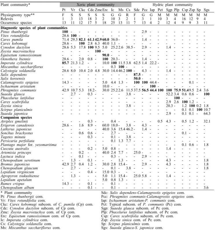
식물군락은 진단종(diagnostic species)에 따라 총 19개 (하위군락 포함)로 분류되었으며, 건생형과 습생형으로 대 분류된다(Table 1, Figure 3). 건생형의 주요 진단종군은 곰 솔, 좀보리사초, 보리사초, 우산대바랭이 등으로 건생입지 에서 출현빈도가 높으며, 습생형은 갈대, 새섬매자기, 천일 사초, 나문재, 개잔디 등으로 습생입지에서 출현빈도가 높 다. 이러한 식물종은 삼림 식물군락과 같이 진단종군을 상 호 공유하지 않는 경우가 많다. 이는 하천 또는 습지에 있어 서의 일반적인 특성이다(Lee and Kim, 2005). 수분이 식물 분포에 가장 큰 영향을 끼치나, 사주섬 일대의 토양이 대부 분 모래이나 입지에 따라 실트(silt)의 함량이 다르기 때문인 것에서도(Ban, 1985) 그 분포가 결정된다. 분류된 식물군락
을 구성하는 식물종은 총 139종이다.
1) 건생 식물군락 (Xeric plant community)
건생 식물군락은 총 9개로 분류되었으며, 해안사구식생 과 해안터주식생, 일부 삼림(교목)식생, 이차초원식생을 포 함한다. 삼림식생 가운데 자생 고유 식물군락은 해송군락 (Pinus thunbergii community)이다. 진우도 서쪽에 분포하 는 해송군락은 과거 고아원 운영 시 방풍 목적으로 식재한 것으로 그 면적은 점차 확장되고 있다(Figure 4 참조). 연안 사주섬 가운데 생성년도가 오래된 진우도, 장자도, 백합등 에는 자연적으로 발달한 해송군락이 분반(patch)상으로 관 찰되며, 국소적으로 분포한다. 한편, 은백양(Populus alba), 아까시나무(Robinia pseudo-acacia), 족제비싸리(Amorpha fruticosa), 해장죽(Arundinaria simonii)과 같은 식재 유래 된 식물로 이루어진 식분들이 분포하기도 한다. 특히, 아까 시나무식재군락은 대부분의 사주섬(진우도, 장자도, 대마등,
Plant community* Xeric plant community Hydric plant community
Pt Vr Ckc Cdc ZmcErc Ic Ms Cs Sdc Pcc Iap Pct Sgp Plp Csp Zsp Sp Sgs
Physiognomy type** F S S S S S G G R F G G M M M M M M M
Relevés 1 3 13 18 3 2 10 3 2 1 3 1 10 3 4 16 12 9 4
Occurrence species 13 11 12 17 5 18 25 13 11 7 13 4 2 12 4 9 9 3 11
Diagnostic species of plant communities
Pinus thunbergii 100 - - - - - - - - - 2.9 - - - - - - - -
Vitex rotundifolia 28.6 100 - - - - - - - - - - - - - - - - -
Carex pumila 71.4 29.3 82.1 61.1 42.9 60.0 36.0 - - - 1.4 - - - - - - - -
Carex kobomugi 28.6 - 100 2.8 6.3 40.0 1.1 - - - - - - - - - - - -
Cynodon dactylon 28.6 5.3 17.8 100 9.5 5.0 25.2 2.6 38.5 - 2.9 - - 1.4 - - - - -
Zoysia macrostachya - - - - 100 - - - - - - - - - - - - - -
Equisetum ramosissimum - - - - - 90.0 - - - - - - - - - - - - -
Oenothera biennis 28.6 - 2.0 0.8 - 100 20.3 - - - 1.4 - - - - - - - -
Imperata cylindrica 85.7 21.3 1.2 - - 10.0 100 11.5 3.8 62.5 1.4 22.2 - - - - - - -
Miscanthus sacchariflorus - - - - - - 0.3 100 - - - - - - - - - - -
Calystegia soldanella 28.6 8.0 10.4 2.0 4.8 30.0 14.4 46.2 100 - 4.3 - - 1.4 - - - - -
Salix dependens - - - - - - - - - 87.5 - - - - - - - - -
Salix koreensis - - - - - - - - - 50.0 - - - - - - - - -
Calamagrostis epigeios 14.3 - - - - 5.0 4.4 1.3 - 100 100 44.4 - - - - 0.1 - -
Ischaemum aristatum - - - - - 10.0 - - - - - 100 - - - - - - -
Phragmites communis 42.9 10.7 5.3 18.2 - 30.0 25.2 2.6 11.5 37.5 56.5 44.4 100 100 75.9 51.49.5 2.4 3.6
Suaeda glauca - 2.7 - 0.3 - - - - 3.8 - - - - 52.2 3.4 0.6 0.6 - 100
Phacelurus latifolius - - - - - - - - - - - - - - 100 - - - -
Carex scabrifolia - - - - - - - - - - - - - 2.9 2.6 100 1.2 - -
Zoysia sinica - - - - - - - - 3.8 - - - - 20.3 - 1.2 100 0.2 1.8
Scirpus planiculmis - - - - - - - - - - - - - - - 0.1 0.1 100 10.7
Suaeda japonica - - - - - - - - - - - - - 2.9 - 0.1 0.1 - 64.3
Companion species
Atriplex gmelinii - - - 0.3 - - 0.4 - - - - - 0.5 4.3 - 0.5 1.2 - 32.1
Erigeron canadensis 28.6 - 1.6 8.9 - 60.0 18.0 - 3.8 - 4.3 - - - - - - - -
Lathyrus japonicus - - - - - 40.0 3.6 15.4 46.2 - 1.4 - - - - - - - -
Sonchus brachyotus - - 0.6 0.6 - - 2.7 - - - - - - - - 0.1 - - -
Tagetes minuta - - - 0.3 - - 0.1 - 3.8 - - - - - - - - - -
Persicaria perfoliata - - - - - - 0.1 1.3 7.7 - - - - - - - - - -
Plantago major for. yezomaritima - - - - - - - - - - - - - - - 0.1 0.6 - 1.8
Cuscuta australis - - - 0.2 - 5.0 0.8 - - - - - - 1.4 - - - - -
Artemisia princeps - - 0.2 - - 40.0 2.4 7.7 - 25.0 - - - - - - - - -
Lactuca indica - - 0.1 - - - 0.3 - - - 2.9 - - - - - - - -
Chenopodium serotinum - 1.3 - 0.1 - - - 1.3 - - - - - 4.3 - - - - 1.8
Bromus japonicus 42.9 2.7 0.4 1.2 - 30.0 2.8 15.4 - - 2.9 - - 4.3 - - - - 1.8
Chenopodium glaucum - 2.7 - - - - 0.1 - 3.8 - - - - - - - - - 1.8
Lepidium virginicum - - - 0.4 - 15.0 0.3 - - - - - - - - - - - -
Agropyron tsukushiense - 1.3 - - - 5.0 1.1 15.4 - 25.0 5.8 - - 1.4 - - - - -
Lepidium apetalum - - - - - 5.0 0.8 1.3 - - - - - - - - - - -
Rumex crispus 14.3 - - 0.1 - - 0.1 - - - - - - - - - - - -
Chenopodium album - - - 0.1 - - 0.1 - - - - - - - - - - - 3.6
* Plant community Sdc: Salix dependens-Calamagrostis epigeios com.
Pt: Pinus thunbergii com. Pcc: Phragmites communis-Calamagrostis epigeios com.
Vr: Vitex rotundifolia com. Iap: Ischaemum aristatum-P. communis com.
Ckc: Carex kobomugi subcom. of C. pumila (Cp) com. Pct: Typical subcom. of P. communis (Pc) com.
Cdc: Cynodon dactylon subcom. of Cp com. Sgp: Suaeda glauca subcom. of Pc com.
Zmc: Zoysia macrostachya com. of Cp com. Plp: Phacelurus latifolius subcom. of Pc com.
Erc: Equisetum ramosissimum com. of Cp com. Csp: Carex scabrifolia subcom. of Pc com.
Ic: Imperata cylindrica com. Zsp: Zoysia sinica com. of Pc com.
Cs: Calystegia soldanella com. Sp: Scirpus planiculmis com.
Ms: Miscanthus sacchariflorus com. Sgs: Suaeda glauca-S. japonica com.
** Physiognomic vegetation types: F: Forest vegetation, S: Sand dune vegetation, G: Secondary grassland vegetation, M: Salt marsh herbaceous vegetation, R: Coastal ruderal vegetation
Other species were omitted by author.
Table 1. Synthesized wild plant community table based on the r-NCD value 백합등, 을숙도)에 식재되었으나, 대형 태풍 루사(2002)와
매미(2003) 등에 의해 그 세력이 쇠퇴되고 있다(탐문조사).
해안사구식생은 순비기나무군락(Vitex rotundifolia community) 과 좀보리사초가 우점하는 식물군락으로 대분류된다. 순비
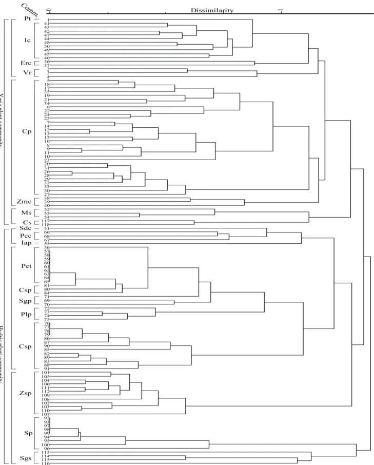
Figure 3. Dendrogram using dissimilarity measure of the vegetation type(plant community types: see Table. 1)
기나무군락은 순비기나무에 의해 구별되며, 진우도와 장자 도의 남단에 좁은 면적으로 생육한다. 좀보리사초군락 (Carex pumila community)은 각각의 종조성에 따라 전형 하위군락(typical subcommunity), 보리사초하위군락 (Carex kobomugi subcommunity), 우산대바랭이하위군락 (Cynodon dactylon subcommunity), 개속새하위군락 (Equisetum ramosissimum subcommunity), 큰잔디하위군 락(Zoysia macrostachya subcommunity)으로 세분류된다.
본 군락은 상대적으로 사구가 발달한 말단 연안사주섬(진우 도와 신자도)의 남방(해양 방향)에 넓은 면적으로 분포한다.
전형하위군락은 상급단위종인 좀보리사초 한 종에 의해 구 분되며, 전사구(foredune)의 전방에 분포한다. 보리사초하 위군락은 전형하위군락보다 후방에 위치하며, 보리사초의 출현빈도가 높은 것이 특징이다. 우산대바랭이하위군락은 전형하위군락의 전방 또는 유사입지에 분포한다. 개속새하 위군락은 대마등의 남방에서만 관찰되며, 겹달맞이꽃, 망 초, 참새귀리와 같은 터주식물(ruderal plant)의 기여도가 높 다. 이것은 과거 대마등 복원 시 인위적인 지형 변화에 따른 결과인 것으로 판단된다. 큰잔디하위군락은 최근에 생성된 신자도와 도요등에서 관찰되었으며, 공간적으로 우산대바 랭이하위군락과 유사하다.
이차초원식생에는 띠와 물억새가 우점하는 2개의 식물군 락이 관찰된다. 띠군락(Imperata cylindrica var. koenigii community)은 섬 중앙 고지의 건조입지에 넓게 발달하며, 띠에 의해 구별된다. 수반종은 우산대바랭이, 겹달맞이꽃, 갯완두, 참새귀리와 같이 주로 건조하거나 훼손된 곳에서 관찰되는 식물종들이다. 본 군락은 진우도, 장자도, 대마등, 백합등, 신자도에서 관찰되며, 다른 식물군락에 비해 비교 적 넓게 분포하고 있다.
물억새에 의해 구분되는 물억새군락(Miscanthus sacchariflorus community)은 건생초본식생 가운데 식생고가 가장 크다.
장자도와 대마등에서 분반 상으로 분포하는 경향이 있다.
수반종 가운데 터주식물인 갯완두, 참새귀리, 개밀의 상대 기여도가 높으며, 미지형적으로 약간 함몰되어 있어 건생 식물군락 가운데 수분조건이 가장 적습하다.
갯메꽃군락(Calystegia soldanella community)은 파도에 의해 각종 쓰레기들이 집적되는 해안 최전방 자갈입지에 주로 발달한다. 이러한 자갈입지는 주로 파도의 영향을 받 는 섬의 남향 해양 방향에 위치한다.
2) 습생 식물군락(hydric plant community)
습생 식물군락은 총 10개로 분류되었으며, 염습지 초본 식생과 개수양버들-산조풀군락(Salix dependens-Calamagrostis epigeios community), 갈대-산조풀군락(Calamagrostis epigeios-Phragmites communis community) 및 쇠보리-갈
대군락(Phragmites communis-Ischaemum aristatum community) 등의 목본식생과 이차초원식생을 포함하고 있 다.
개수양버들-산조풀군락의 생육 입지는 진우도에서 과거 경작이 이루어졌던 요철지(凹凸地)로 경작방기 이후 발달 한 식분이다. 요철의 돌출지(凸地)에서는 띠가, 함몰지(凹 地)에서는 산조풀과 갈대가 생육하는 식물분포의 미세한 차이가 뚜렷히 관찰된다. 갈대-산조풀군락은 습생초본식생 가운데 가장 건조한 입지에 발달한다. 본 군락은 진우도, 백합등, 장자도에서 관찰되나, 진우도에는 경작 방기지에 넓은 면적으로 생육하고 있다. 쇠보리-갈대군락은 백합등에 서만 조사되었으며, 점점이 좁은 면적으로 분포한다.
갈대군락, 새섬매자기군락 등 전술의 3개군락을 제외한 7개의 식물군락(하위군락 포함)은 매일 조석의 영향을 직접 적으로 받는다. 갈대군락(Phragmites communis community) 은 본 지역의 습성입지를 대표하는 식물군락으로 모든 섬에 넓은 면적으로 분포한다. 갈대군락은 전형하위군락(typical subcommunity), 나문재하위군락(Suaeda glauca subcommunity), 모새달하위군락(Phacelurus latifolius subcommunity), 천 일사초하위군락(Carex scabrifolia subcommunity), 개잔디 하위군락(Zoysia sinica subcommunity)으로 세분류된다.
나문재하위군락은 만조위선을 따라 1m 내외 폭으로 대상 형으로 분포하며, 주로 쓰레기 등이 집적되는 장소이다. 장 자도, 백합등에 분포하는 모새달하위군락은 나문재하위군 락보다 전방의 만조위선 가까운 저지 또는 직후방의 저지에 부분적으로 발달한다. 전형하위군락은 모새달하위군락과 유사한 입지에 분포하지만, 해양 방향으로 보다 전방이다.
천일사초하위군락의 생육입지는 전형하위군락의 외곽 가 장자리이며, 갈대가 혼생하는 경우가 많다. 개잔디하위군락 은 천일사초하위군락과 새섬매자기군락 사이에 분포하는 경우가 많다. 개잔디하위군락은 분반 상의 분포 경향성을 가지며, 모든 섬에서 관찰된다. 생육입지의 미세지형은 구 분종인 개잔디의 뿌리가 토양을 고정하여 약간 돌출한 형태 를 가진다.
새섬매자기군락(Scirpus planiculmis community)은 흔 히 새섬매자기 1종이 단일 우점하는 형태가 대부분이다. 총 출현종수는 3종으로 빈약하며, 수반종으로 애기거머리말이 혼생하는 경우가 많다. 본 군락은 갈대군락 외곽의 간석지 에 넓게 발달하고 있으며, 진우도에는 그 분포면적이 작다.
나문재-칠면초군락(Suaeda glauca-S. japonica community) 의 입지는 조석 시 물이 서서히 나드는 곳으로 토양 공극률 이 높은 것이 특징이다. 식생 피도는 평균 30~40%에 불과 하다. 전술의 개잔디하위군락, 새섬매자기군락, 나문재-칠 면초군락의 생육입지는 간조 시에만 육상에 노출되는 곳으 로 식분은 매일 침수를 경험한다.
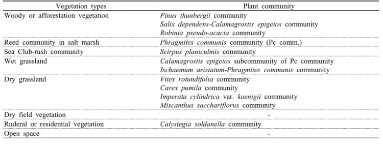
Vegetation types Plant community Woody or afforestation vegetation Pinus thunbergii community
Salix dependens-Calamagrostis epigeios community Robinia pseudo-acacia community
Reed community in salt marsh Phragmites communis community (Pc comm.) Sea Club-rush community Scirpus planiculmis community
Wet grassland Calamagrostis epigeios subcommunity of Pc community Ischaemum aristatum-Phragmites communis community Dry grassland Vitex rotundifolia community
Carex pumila community
Imperata cylindrica var. koenigii community Miscanthus sacchariflorus community
Dry field vegetation -
Ruderal or residential vegetation Calystegia soldanella community
Open space -
Table 2. Properties of the actual vegetation map(except open water)
Vegetation type DM DY MG BH JJ US SJ JU Total
Woody or afforestation vegetation 4,153 0 0 1,840 0 1,341 0 87,592 94,927 Reed community in salt marsh 164,352 4,352 35,761 218,883 468,113 901,011 119,019 45,297 1,956,789 Sea Club-rush community 1,110,543 0 1,009,298 75,534 243,103 330,404 9,502 0 2,778,383 Wet grassland 0 0 105,262 153,076 100,043 6,928 112,699 288,427 766,435 Dry grassland 135,566 33,706 0 25,100 102,472 615,636 233,091 392,973 1,538,543 Dry field vegetation 0 0 0 0 0 0 0 21,172 21,172 Ruderal or residential vegetation 0 0 0 0 0 568,510 0 2,825 571,335 Open space 3,149 447,342 0 0 5,701 0 256,338 113,428 825,958 Total 1,417,763 485,399 1,150,321 474,433 919,432 2,423,830 730,648 951,715 8,553,542 DM: Daemadeung, DY: Doyodeung, MG: Maenggeummeorideung, BH: Baekhapdeung, JJ: Jangjado, US: Ulsukdo, SJ: Sinjado, JU: Jinudo
Table 3. Vegetation states by the each island
2. 현존식생도본 조사지역의 현존식생도 범례는 총 8개(목본식생, 염습 지 갈대군락, 새섬매자기군락, 습생초원식생, 건생초원식 생, 밭경작지식생, 터주·주거식생, 개방나지, 개방수역)로 구분되었다(Table 2, 3; Figure 4). 가장 넓은 면적을 구성하 는 식생유형은 새섬매자기군락, 염습지 갈대군락, 건생초원 식생이다. 대부분의 사주섬 가장자리에 염습지 갈대군락이 대상으로 분포하며, 그 외곽에 새섬매자기군락이 발달하고 있다. 염습지 갈대군락은 흔히 만조위선까지 발달하고 있 다. 건생초원식생은 섬의 중앙부 고지에 발달하고 있으며, 해안 사구식생은 말단사주섬의 전방(해양 방향, 남향)에, 염 습지식생은 말단사주섬의 후방(내륙 방향) 지역에 발달한 다.
목본식생에는 해송군락, 개수양버들-산조풀군락, 조림군 락(아까시나무군락, 해장죽군락)이 포함된다. 조림군락 가
운데 족제비싸리식재군락 등은 그 면적이 매우 작아 현존식 생도 상에는 표현되지 않는다. 목본식생은 진우도에 가장 넓게 분포하고 있으며, 대부분 과거 식재로부터 기인한 식 분들이 많다. 염습지 갈대군락은 을숙도 남쪽과 서쪽 지역 에 가장 넓게 분포하며, 서쪽 지역은 과거 경작지(대부분 파)였으나, 염습지 갈대군락으로 복원되었기 때문이다. 또 한 장자도와 백합등에도 넓게 발달하고 있다. 새섬매자기군 락은 간석지에 발달하고 있으며, 대마등 북쪽과 맹금머리등 남쪽 지역, 을숙도 남쪽 지역에 넓게 분포한다.
습생초원식생에는 산조풀하위군락, 쇠보리-갈대군락이 포함된다. 진우도에 경작이 방기된 함몰된 지역에 본 식생 이 넓게 발달하고 있다. 건생초원식생은 해안 사구식생과 띠군락, 물억새군락이 포함된다. 을숙도, 진우도, 신자도에 본 유형이 매우 넓게 분포하고 있다. 특히, 진우도와 신자도 는 섬 중앙부를 중심에서 해양방향(남향)의 가장자리로 띠 군락과 사구식생이 발달하고 있다. 경작지 식생은 현재까지 경작이 일부 이루어지고 있는 진우도에서 부분적으로 관찰
Figure 4. Actual vegetation map of study area
된다. 터주·주거식생은 을숙도에 넓게 분포하며, 주로 과거 쓰레기매립지였던 을숙도 내부에 발달하고 있다. 섬의 중앙 에서 서쪽 방향으로 명지대교 건설을 위한 공사가 진행되고 있어 터주·주거식생이 존재하고 있다. 개방나지는 식생이 피복되지 않는 사주공간으로 섬의 성장과 더불어 장기적으 로 식생의 진행천이(progressive succession)가 일어난다.
도요등, 신자도, 진우도에 넓게 관찰된다. 한편, 실제 해안선 (해발고도 0m)보다 저지인 간석지 공간에 발달하는 식생은 을숙도, 맹금머리등, 대마등에서 상대적으로 넓다
3. 종합고찰
본 연구를 통해 낙동강 하구역 일대 사주섬을 중심으로 총 19개가 분류되었으며(Table 1), 삼림 및 조림식생, 해안 사구식생, 이차초원식생, 염습지 초본식생, 해안터주식생으 로 대분류되었다. 집괴분석에서 식물군락은 생육지의 수분 조건에 따라 건생형(xeric type)과 습생형(hydric type)으로 구분되었다(Figure 3). 해송군락, 해안사구식생, 띠군락, 물 억새군락, 갯메꽃군락은 건생형(XT: xeric type)으로 구분 된다. 습생형은 식물체가 일중 관수되지 않는 갈대모둠(RS:
reed subtype)과 새섬매자기군락과 나문재-칠면초군락과 같이 일중 관수를 경험하는 비갈대모둠(nRS: non-reed subtype)으로 다시 구별된다. 이는 해양에서 섬 중심으로 nRS-RS-XT로 연속적으로 식생이 변화하는 패턴이다. 습 생형이 두 개로 구분된 것은 식물군락 간에 공유하는 종이 매우 적고, 단일 우점하는 식물종조성적 특성과 조석에 의 해 발생하는 해수면 변화에 의해 크게 결정되기 때문이다.
해송군락은 한반도 해안지역의 잠재자연식생(potential natural vegetation)으로 사주섬이 쇠태하지 않는다면 지속 적인 확장이 예상된다. 사주섬이 쇠퇴하는 백합등과 장자도 (Kim, 2005)를 제외하고는 본 군락이 확장할 것이다. 순비 기나무군락은 전형적인 난온대성 해안사구관목군락으로 (Miyawaki and Okuda, 1990; Kim and Nam, 1996; Jung, 2000), 사구의 확장이 예상되는 말단 사주섬인 진우도와 신 자도에서의 확장이 예상된다. 특히, 장자도의 순비기나무군 락은 1975년 해양 방향에 신자도가 생성(Ban, 1985)되어, 사 구가 발달한 남단이 염습지 환경으로 변했기 때문에 쇠퇴가 명백히 관찰된다. 이러한 순비기나무군락은 보다 고위도 지 역에서는 북방기원인 해당화군락(Rosa rugosa community) 으로 대체된다(Miyawaki and Okuda, 1990; Kim and Nam, 1996; Jung, 2000).
초본식생이 우세한 본 지역에서 건생은 좀보리사초군락과 띠군락이, 습생은 갈대군락과 새섬매자기군락이 가장 대표 적인 것으로 나타났다. 건생지역은 사구식생으로, 습생지역 은 염습지 식생으로 대표되는 것으로 Mun and Kim(1985b)
의 연구와 같다. 좀보리사초군락은 해안사구식생을 대표하 는 식물군락으로(Miyawaki and Okuda, 1990), 하천에 형 성된 사주에도 관찰된다(Lee, 2004). 본 군락은 사주섬이 성장하고 쇠퇴하는 것에 대응하여 전진 또는 후퇴할 것으로 예상된다. 한반도 사구식생의 주요식물들은 순비기나무, 해 당화, 좀보리사초, 갯쇠보리, 갯메꽃, 보리사초, 띠 등이며 (Lee and Chon, 1984; Jung and Kim, 1998), 염습지는 갈대 등으로(Lee, 2004; Lee and Kim, 2005) 본 연구와 유사하였 다.
띠군락은 굵은 뿌리를 가지고 있어 지하부에 생체량을 많이 배분하는 전략으로 건조 환경에 매우 유리하다(Kim and Chai, 1969). 따라서, 본 지역의 사구 성장과 더불어 정착한 띠는 지속적으로 유지 또는 확장할 것으로 예측된 다. 물억새군락은 하천변 모래땅에서 관찰되는 물억새-갈풀 군집(Phalarido-Miscanthethum sacchariflori; Lee, 2004)과 유사하지만 갈풀이 부재된 것이 다르다.
건생형의 식물군락 내에서도 습생입지의 주요종인 갈대 가 높은 기여도로 나타나는 특성이 있다. 이는 지하 번식체 (propagule; 뿌리)로 확장하는 갈대의 번식전략 때문인 것 으로 파악된다. 본 지역에서 갈대 개체군의 가장자리는 하 절기에 태풍의 영향이 빈번하여 쉽게 파괴된다. 파괴된 갈 대 조각들은 파도에 의해 말단사주섬의 남단에 집중 퇴적되 며, 이중 생식력 있는 갈대의 파편은 적합한 기회에 사구에 빠르게 뿌리를 내려 정착할 수 있다. 이후 지하수위(water table) 근처까지 뿌리를 내려 지하경으로 개체를 확장해 나 가는 것으로 추측된다. 이러한 파편화된 갈대 조각 및 현상 은 말단사주섬의 배사구(embryo dune)에서 태풍 발행 이후 쉽게 관찰된다. 개괄적 실측결과, 갈대는 말단사주섬의 가 장 건조한 고지에서 토양 단면 상 수분 조건이 약습-적습한 깊이(80~100㎝ 내외, pers. obs. unpubl. cf. 섬 가장자리는 10㎝깊이)에 지하경이 존재하였다. 즉 건조한 토양에 생육 하는 갈대는 땅속에 다른 식물과 분리된 독립된 공간 지위 를 가짐으로서 유지 가능한 것이다. 관련 연구는 차후 보다 깊이 다루어져야 할 것으로 판단된다.
염습지(습생)의 주요 식물 가운데 갈대와 새섬매자기는 북반구의 염습지에 널리 분포하고 있다(Lee, 1996a). 특히 염습지 갈대군락은 개개비류의 중요한 서식공간이 되며, 새 섬매자기는 저서생물의 서식처가 되는 동시에 겨울철 고니 류와 같은 수금류들의 중요한 먹이식물(Groenendijk, 1985;
Doornbos et al., 1986; Hong, 2004; Kim et al., 2005)로 본 지역에서 우산종(umbrella species)의 역할을 한다. 이러 한 식생자원과 조류의 분포와의 상관관계를 보다 면밀히 밝힌다면 철새도래지로서 지역생태계 기능을 강화시킬 수 있을 것이다. 따라서, 갈대군락과 새섬매자기군락은 장기적 인 모니터링이 요구되는 식생자원이다.
인용문헌
An, S.M., J.Y. Lee and S.J. Jeong(2006) Seasonal biomass and car- bon, nitrogen contents change of Schoenoplectus triqueter in Nakdong river estuary. Kor. J. Wet. 8(3): 39-49. (in Korean with English abstract)
Ban, Y.B.(1985) Sediment Grain Size Distribution of the Nakdong:
River Delta. Kor. J. Geo. 10: 713-737. (in Korean with English abstract)
Becking, R.W.(1957) The Zürich-Montpellier school of phytosociology. Bot. Rev. 23(7): 411-488.
Braun-Blanquet, J.(1928/1965) Pflanzensoziologie. 1st eds.
Springe r-Verlag. Wien. 3rd eds. Wien: Springer-Verlag, 865pp.
Breckle, S.W.(2002) Walter's vegetation of the ecology: The eco- logical systems of the geo-biosphere. Springer, 21pp.
Busan regional meteorological administration(2012) Past da- ta(1979~2008): Observation data. Seoul: KMA. (Accessed 19 September, 2009: http: //www.kma.go.kr/weather/observation/
past_table.jsp).
Chang, N.K. and B.C. Kang(1977) Changes of plant communities to cotinuum and species diversity on the gradient of the water table in the delta of the Nakdong-river. Kor. J. Ani. Sci. 19:
453-458. (in Korean with English abstract)
Cho, J.K.(1992) The topographical changes and vegetation survey of the sand bars in the Naktong River Estuary. Inje J. 8(2):
639-647. (in Korean with English abstract)
Costanza, R., R. d'Arge, R. de Groot, S. Farber, M. Grasso, B.
Hannon, K. Limburg, S. Naeem, R.V. O'Neill, J. Paruelo, R.G.
Raskin, P. Sutton and M. van den Belt(1997) The value of the world's ecosystem services and capital. Nat. 387: 253-260.
Doornbos, G., A.M. Groenendijk and Y.W. Jo(1986) Nakdong es- tuary barrage and reclamation project: Preliminary results of the botanical, macrozoobenthic and ornithological studies. Bio.
Con. 38(2): 115-142.
ESRI inc.(2006) ESRI ArcGIS version 9.2. California: Environmental System of Research Institute.
Groenendijk, A.M.(1985) Foodplant biomass and feeding behavior of Geese and Swan in Nakdong river area: emphasis on the pol- der areas. Delta institute-NEDECO, 20pp.
Ha, J.H.(1993) A study on vascular hydrophtes in Nakdong estuary after construction of the Nakdong estuary barrage. M. Sc., Univ. of Dong-A, Pusan, Korea, 37pp. (in Korean with English abstract)
Hong, S.B.(2004) Regional characteristics of bird in Nakdong estuary. Kor. J. orni. 11(2): 55-70. (in Korean with English ab- stract)
Jung, Y.H. and H.G. Choi(1983) Flora and distribution of vascular hygro-and hydrophytes from the estuary of Nagdong river. J.
P. Bio. 26(4): 197-206. (in Korean with English abstract) Jung, Y.K. and J.W. Kim(1998) Coastal sand dune vegetation in
Kyung pook province. Kor. J. Ecol. 21: 257-262. (in Korean with English abstract)
Jung, Y.K.(2000) The Viticetea rotundifoliae in South Korea and Japan. Kor. J. Ecol. 23: 383-389. (in Korean with English ab- stract)
KHOA(1977~2007) Tidal observation DB-Gadeok island. Korea knowledge portal. (accessed 9 October, 2010: https://www.
knowledge.go.kr/SearchSF1/search_result_dir_knowl- edgedb_list.jsp?kind_cd=08&know_cd=101).
Kim, C.H., K.B. Lee, J.D. Kim, T.D. Cho and M.S. Kim(2005) The Study on the Flora and Vegetation of Salt Marshes of Dongjin-river estuary in Jeonbuk. J. Env. Sci. 14(9): 817-825.
(in Korean with English abstract)
Kim, D.A. and Y.S. Chai(1969) A Study on the Competition be- tween Imperata cylindrica and Reed Canary Grass(Phalaris arundinacea) on Natural Grassland. Kor. J. ani. sci. 11(3):
318-322. (in Korean with English abstract)
Kim, G.Y.(2006) Grazing impact of wintering waterfowl on growth dynamic of Schoenoplectus triqueter in the Nakdong river estuary. Ph. D. thesis, Univ. of Pusan, Pusan, Korea, 143pp.
Kim, G.Y., C.W. Lee, and G.j. Joo(2004a) Growth pattern of Scirpus triqueter after wintering swans foraging activity, the l7th INTECOL international wetlands conference in Utrecht, the Netherands, pp. 25-30.
Kim, G.Y., C.W. Lee, H.S. Yoon and G.J. Joo(2005) Changes of distribution of vascular hydrophytes in the Nakdong river es- tuary and growth dynamics of Schenoplectus triqueter, water- fowl food plant. Kor. J. Ecol. 28: 335-345. (in Korean with English abstract)
Kim, G.Y., C.W. Lee, S.B. Park and G.J. Joo(2004b) Grazing activ- ity of wintering waterfowl on the food plant Scirpus triqueter in a tidal mud flat, The First Korea-Japan Joint Symposium on Limnology, 4pp.
Kim, J.H., H.T. Mun, B.M. Min and K.J. Cho(1989) Nitrogen and phosphorus dynamics in a salt marsh in the Nakdong river estuary. Kor. J. Ecol. 12: 1-7. (in Korean with English abstract) Kim, J.H., K.J. Cho, H.T. Mun and B.M. Min(1986) Production dy- namics of Phragmites longivalvis, Carex scabrifolia and Zoysia sinica stand of a sand bar at the Nagdong river estuary.
Kor. J. Ecol. 9: 59-71. (in Korean with English abstract) Kim, J.W. and H.K. Nam(1996) On the southernmost distribution
of the Rosa rugosa community. J. Inst. Nat. Sci. 15(2): 149-156.
(in Korean with English abstract)
Kim, J.W. and S.Y. Kim(2006) Computer programe for syntaxon- omy [RIM] var. 2.1. KIEM.
Kim, J.W. and Y.K. Lee(2006) Classification and assessment of plant communites. World science, Seoul, pp. 33-85. (in Korean)
Kim, J.W.(2004) Vegetation ecology-2nd. World science, Seoul, 37pp. (in Korean)
Kim, S.H.(2005) (The)Morphological changes of Nakdong river deltaic barrier islands after the construction of river barrage. Ph.
D. thesis, Univ. of Seoul, Seoul, Korea, 158pp.
Lee W.T.(1996a) Lineamenta florae Koreae. Academy, Seoul, 624pp. (in Korean)
Lee W.T.(1996b) Standard illustrations of Korean plants.
Academy, Seoul, 1,688pp. (in Korean)
Lee, S.H. and J.H. Kim(2002) Study on the direction of marine sedi- ment transport and the geomorphological servey of sand bar in Nakdong river estuary(Ⅱ). Korean society of civil engineers 22: 365-370. (in Korean with English abstract)
Lee, W.T. and S.K. Chon(1984) Ecological studies on the coastal plants in Korea: On the sand dune vegetation of the western coast. Kor. J. Ecol. 7: 74-84. (in Korean with English abstract) Lee, Y.J.(2000) Flora and vegetation of the Naktong river Mouth.
M. Sc., Univ. of Keimyung, Deagu, Korea, 61pp. (in Korean with English abstract)
Lee, Y.K. and J.W. Kim(2005) Riparian vegetation of South Korea.
Keimyung university press, Deagu, pp. 183-225. (in Korean with English abstract)
Lee, Y.K.(2004) Syntaxonomy and synecology of the riparian veg- etation in South Korea. Doctor of philosophy, Keimyung university. pp. 52-53. (in Korean with English abstract) MEV⋅NIER(2006) Wetland reserves research-Nakdong river es-
tuary⋅Upo wetland⋅Mujechi. NIER, pp. 25-76. (in Korean) MEV⋅UNDP/GEF Korea Wetland PMU(2006) The compre- hensive survey for expanding the wetland conservation areas of the Nakdong river. MEV, pp. 31-88. (in Korean with English abstract)
Microsoft corp.(2003) Microsoft Office 2003 Excel.
Miyawaki, A. and S. Okuda(1990) Vegetation of Japan Illustrated.
Shibundo, Tokyo, 910pp.
MLTM(2008) Statistical, year book of MLTM-1st. MLTM, Gwacheon, 527pp.
Mueller-Dombois, D. and H. Ellenberg(1974) Aims and methods of vegetation ecology. John Willy & Sons, New York, pp. 45-66.
Mun, H.T. and J.H. Kim(1985a) Studies on plant succession of sand bars at the Nakdong river estuary: vegetation and soil environment. Kor. J. Bot. 28: 79-93. (in Korean with English abstract)
Mun, H.T. and J.H. Kim(1985b) Studies on plant succession of sand bars at the Nakdong river estuary: vegetation development and interspecific associations. Kor. J. Bot. 28: 191-198. (in Korean with English abstract)
Nakdong estuary eco center(2010) Nakdong river estuary: About us. (accessed 20 October, 2010: http: //wetland.busan.go.kr/
02ecology/01_03.jsp)
Oh, G.H.(1999) Landform changes of terminal area of the Nagdong river delta, Korea. Kor. J. Qua. Resr. 13(1): 67-78. (in Korean with English abstract)
Park, S.H.(1999) Colored illusrations of nationlized plants of Korea. Ilchokak, Seoul, 372pp. (in Korean)
Park, S.H.(2001) Colored illusrations of nationlized plants of Korea: Appendix. Ilchokak, Seoul, 178pp. (in Korean) Podani, J.(2001) SYN-TAX 2000: Computer program for data anal-
ysis in ecological and systematics. Scientia Publishing, Budapest.
Reid, G.K. and R.D. Wood(1976) Ecology of inland waters and estuaries. D. Van Nostrand Co., New York, 485pp.
Westhoff, V. and E. van der Maarel(1973) The Braun-Blanquet approach. Ed. R. H. Whittaker. Ordination and classification of communities. Dr. W Junk by Publisher, Hague, pp. 167-726.
Yi, G.C., H.S. Yoon, S.H. Kim, C.H. Nam and J.A. Ok(1999) A study of the development of wetland database for the Nakdong river estuary using GIS and RS. Kor. Ass. Geo. 2(3): 1-15. (in Korean with English abstract)
Yoon, H.S.(1984) A Study on the vegetation in Nakdong Estuary-The biomass of food plants for the migration birds.
Res. works of the graduate school 9: 363-371. (in Korean with English abstract)
Yoon, H.S.(1991) A study on vascular hydrophytes of intertidal area in Nakdong estuary. Kor. J. Ecol. 14(1): 63-73. (in Korean with English abstract)