기후변화에 따른 한반도 사스레피나무의 생육지 예측과 영향 평가
윤종학*·박정수*·최종윤*·中尾勝洋**
국립생태원 생태평가연구실*, 일본산림총합연구소 식물생태학 연구실**
Habitat Prediction and Impact Assessment of Eurya japonica Thunb.
under Climate Change in Korea
Jong-Hak Yun*·Jeong Soo Park*·Jong-Yun Choi*·Katsuhiro Nakao**
*Div. of Ecological Assessment, National Institute of Ecology
**Dep. of Plant Ecology, Forestry and Forest Products Research Institute
요 약 : 본 연구는 사스레피나무의 분포를 규정하는 기후요인과 종분포 모델을 이용하여 현재기후와 미래 기후에서의 잠재생육지를 분석하기 위해 수행되었다. 4개 기후요인(온량지수, 최한월최저기온, 하계강 수량, 동계강수량)은 모델에서 독립변수로 사용하였다. 17개 전지구 기후모델(GCMs; General Circulation Models)에 의한 RCP(대표농도경로) 8.5 시나리오를 2050년(2040~2069)과 2080년(2070~2099)의 미 래기후로 사용하였다. 사스레피나무(Eurya japonica)에 대한 종분포 모델은 높은 분포예측 모델로 구축 되었다. 사스레피나무의 분포모델에서 최한월최저기온이 사스레피나무 분포를 규정하는 주요 기후요인으 로 분석되었다. 최한월최저기온 -5.7℃이상 지역은 사스레피나무의 높은 출현확률을 나타내었다. 사스레 피나무의 잠재 생육지는 2050년과 2080년에서 현재기후에서 보다 각각 2.5배, 3.4배 증가되었으며, 기후 변화에 의해 점점 확대될 것으로 판단되었다. 사스레피나무는 한반도에서 기후변화 지표종으로 가능하며, 잠재 생육지를 모니터링 할 필요가 있다.
주요어 : 종분포 모델, 지표종, 잠재 생육지
Abstract : The research was carried out in order to find climate factors which determine the distribution of Eurya japonica, and the potential habitats (PHs) under the current climate and climate change scenario by using species distribution models (SDMs). Four climate factors; the warmth index (WI), the minimum temperature of the coldest month (TMC), summer precipitation (PRS), Research Paper
First Author: Jong-Hak Yun, Div. of Ecological Assessment, National Institute of Ecology, Seocheon 33657 Korea Tel: +82-41-950-5360, E-mail: [email protected]
Corresponding Author: Jong-Hak Yun, National Institute of Ecology, Seocheon 33657 Korea Tel: +82-41-950-5360, E-mail: jhyun225@
nie.re.kr
Co-Authors: Jeong Soo Park, National Institute of Ecology, Seocheon 33657 Korea Tel: +82-41-950-5353, E-mail: [email protected] Jong-Yun Choi, National Institute of Ecology, Seocheon 33657 Korea Tel: +82-41-950-5351, E-mail: [email protected]
Katsuhiro Nakao, Dep. of Plant Ecology, Forestry and Forest Products Research Institute, Kyotosi 612-0855 Japan Tel: +81-75-366- 9923, E-mail: [email protected]
Received: 31 May, 2017. Revised: 5 September, 2017. Accepted: 8 September, 2017.
https://doi.org/10.14249/eia.2017.26.5.291
I. 서 론
기후변화에 관한 정부간 협의체(IPCC: Inter - governmental Panel on Climate Change)의 제5 차 평가보고서에 의하면 기후변화로 인한 전지구 평 균기온은 지난 133년 동안(1880~2012년) 0.85℃ 상 승하였다. 향후 21세기 말(2081~2100년) 온실가스 감축 없이 현재 추세대로 온실가스를 배출할 경우 (RCP 8.5) 전지구 평균기온은 현재(1986~2005년) 보다 약 3.7℃ 오르고, 해수면의 높이는 약 63m 상 승할 것을 전망하였다(IPCC 2013).
기후변화로 인한 동물과 식물의 생육범위가 극지 방향과 고도가 높은 지역 이동함으로써 육상 생태계 에 영향을 미치고 있다(Parmesan & Yohe 2003).
최근에는 식물종의 분포를 예측하기 위해 현재기후 에 대응하는 분포지역을 통계모델을 구축하여 미래 기후에서의 잠재적인 분포지역을 예측하는 연구가 진행되고 있다.
기후변화에 의한 식물 분포 예측 연구는 미국과 유럽 을 중심으로 활발히 연구가 진행되고 있으며(Huntley et al. 1995; Iverson & Prasad 1998; Berry et al.
2003; Thuiller et al. 2005; Normand et al. 2007), 식물 분포의 정량적 예측을 위해 다양한 종분포 모델 (SDMs: Species distribution models)이 이용되고 있다. 종분포 모델 중에서 CT-model(Classification tree model)을 이용하여 일본의 낙엽활엽수종인 너 도밤나무(Fagus crenata)(Matsui et al. 2004a,
2004b), 섬조릿대(Sasa kurilensis)(Tsuyama et al.
2008), 눈잣나무(Pinus pumila)(Horikawa et al, 2009), 상록성 참나무과 2종(붉가시나무; Quercus acuta, 참가시나무; Q. salicina)(Nakao et al. 2009) 등의 잠재적 생육지를 예측하여 보고하였다. 또한, GAM(Generalized additive model)을 이용하여 한 반도 난온대 상록활엽수 4종(붉가시나무; Q. acuta, 구실잣밤나무; Castanopsis sieboldii, 참식나무;
Neolitsea sericea, 후박나무; Machilus thunbergii) (Yun et al. 2014b), 일본과 대만의 상록활엽수 10종 (구실잣밤나무; C. sieboldii, 동백나무; Camellia japonica, 조록나무; Distylium racemosum, 대만 고무나무; Ficus microcarpa 등)(Nakao et al. 2014) 등의 연구보고가 있다. 그 외에도 식물종의 분포와 통계해석을 위해 RF(Random forest), MaxENT (Maximum Entropy Modeling) 등의 통계모델을 이 용하여 연구되고 있다(Nakao et al. 2011; Kummar 2012).
기후변화로 인해 한반도 남부해안 및 제주도, 울릉 도 저지대 등에 분포하는 난온대 상록활엽수는 고위 도 및 고해발로 확대 될 것으로 예측된다(Yun et al.
2011a). 사스레피나무(Eurya japonica)는 한반도의 난온대 상록활엽수의 북한계선을 결정하기 위해 선 정된 64종 중의 하나이다(Uyeki 1941). 다른 난온대 상록활엽수종에 비하여 고위도에 분포하고 있으며 (Uyeki 1941; Yun et al. 2011a), 기후변화에 따른 and winter precipitaion (PRW) : were used as independent variables for the model. Seventeen general circulation models under RCP (Representative concentration pathway) 8.5 scenarios were used as future climate scenarios for the 2050s (2040~2069) and 2080s (2070~2099). Highly accurate SDMs were obtained for E. japonica. The model of distribution for E. japonica constructed by SDMs showed that minimum temperature of the coldest month (TMC) is a major climate factor in determining the distribution of E. japonica. The area above the -5.7℃ of TMC revealed high occurrence probability of the E. japonica. Future PHs for E. japonica were projected to increase respectively by 2.5 times, 3.4 times of current PHs under 2050s and 2080s. It is expected that the potential of E. japonica habitats is expanded gradually. E. japonica is applicable as indicator species for monitoring in the Korean Peninsula. E. japonica is necessary to be monitored of potential habitats.
Keywords : Species distribution model, Indicator, Potential habitats
분포확대 가능성이 높은 난온대 상록활엽수종이다.
사스레피나무는 제주도 해안가와 산지, 남해안 도서 및 남부지역 산기슭에 분포하며, 최근 가속화 되는 기후변화로 인해 한반도 내륙으로 세력을 확대할 것 으로 예상되며, 식물군락을 구성하는 종조성에도 영 향을 미칠 것으로 판단된다.
본 연구는 사스레피나무를 대상으로 종분포 모델 을 구축하여 현재기후에서 분포를 규정하는 기후조 건을 정량적으로 밝히고, 신(新)시나리오 RCP 8.5를 적용하여 미래기후에서의 잠재 생육지 분포 변화와 기후변화에 따른 영향을 평가하고자 하였다.
II. 재료 및 방법
1. 연구 대상지
연구 대상지는 북위 33°~38°, 동경 126°~132°에 놓여 있는 한반도, 제주도, 울릉도를 포함하는 지역 으로, 북으로는 러시아, 중국의 국경을 접하고 있으며, 동으로는 동해를 사이에 두고 일본열도가 위치하고 있다. 한반도에는 약 14개의 산맥이 있으며 그 중에 서 가장 긴 백두대간이 한반도의 동부에 연하여 위치 하고 있으며 동쪽은 급경사를 이루고 서쪽은 완만한
지형을 이루고 있다. 한반도에서 남쪽에는 제주도, 동쪽에는 울릉도가 위치하고 있다. 한반도의 기후는 전반적으로 연교차가 큰 대륙성 기후의 지배를 받고 있으며, 최근 한반도의 10년(1991-2000년) 평균기 온은 13.7℃, 제주도 14.4℃, 울릉도 11.8℃를 나타 내고 있다(Yun et al. 2011a).
2. 식물분포 자료
식물분포 자료는 국립생물자원관(Hurbarium Code: KB)에 소장된 식물 표본 자료와 국립생태원 의 에코뱅크(ecobank.nie.re.kr)의 전국자연환경조 사의 식생자료에서 사스레피나무의 분포 정보를 이 용하였다. 한반도 식물 분포 자료만으로 난온대 상 록활엽수의 생육지를 예측할 경우, 과소 또는 과대 평가되어 예측 될 수 있음으로, 이를 보정하기 위해 일본의 식생 조사 자료를 근거하여 작성된 PRDB (Phytosociological Releve Data Base)(Tanaka 2007) 에서 사스레피나무의 분포 정보를 추출하여 생육지 분포 예측 이용하였다. 추출된 사스레피나무의 위치 정보는 총 4,091(한국 740; 일본; 3,351)지점이며, 한국과 일본 지역을 대상으로 사스레피나무의 실제 분포도를 작성하였다(Figure 1).
Figure 1. Actual distribution of E. japonica. The number of the presence of E. japonica was 4,091 records
3. 기후자료
기후자료는 Worldclim-Global Climate Data (www.worldclim.org)에서 한국과 일본 지역을 대상 으로 해상도 30arc-seconds(ca. 1km) 격자에 대하 여 기후값을 추출하여 이용하였다. 식물 생육에 중요 한 온량지수(WI: Warmth Index)(Kira 1977)는 월평 균기온 5℃이상인 달에 대하여 월평균기온에서 5℃를 감하여 합계한 값이며(Kira 1977), 식물성장기의 열 량 지표로서 동아시아지역의 광역적 식물분포를 이해 하는데 중요한 기후요인이다(Ohsawa 1990). 최한월 최저기온(TMC; Mean minimum temperature of the coldest month)은 식물생육과 분포의 제한요인 의 최저기온 극한값으로 월평균기온이 최저인 달의 최저기온의 값이다(Ohsawa 1991; Ohsawa 1993).
하계(5~9월)강수량(PRS; Summer precipitation), 동계(12~3월)강수량(PRS; Summer precipitation) 은 식물성장기의 강수요인으로 수분량 지표이다. 4가
지 기후변수(WI, TMC, PRS, PRW)에 대하여 30년 (1971∼2000년) 평균기후 값을 현재기후 자료(Current climate data)로 적용하였다(Table 1).
미래기후 자료는 IPCC(Intergovernmental Panel on Climate Change) 제5차 평가보고서(AR5)에서 대표농도경로(RCP: Representative Concentration Pathway)에 의한 시나리오를 사용하였다. 현재 추 세(저감없이)로 온실가스 배출되는 RCP8.5를 적용 하여 다른 RCP 시나리오(2.6, 4.5, 6.0)에 비하여 가장 나쁜 상태에서의 2050(2060~2089)년, 2080 (2070~2099)년의 30년 평균 기후값을 이용하여 분 포 변화를 예측하였다.
또한, 미래기후의 불확실성에 대한 예측을 최소화 하기 위하여 17개 전지구 기후모델(GCMs: General Circulation Models)에서 생산한 미래시나리오를 사 용하였다(Table 1).
현재기후에서 한반도 지역의 온량지수(WI)는 78.1℃·month, 최한월최저기온(TMC) -13.0℃, 하계 Table 1. The mean values of four climatic variables under the current climate (1971-2000) and future climate scenarios of 17 GCMs(General Circulation Models) for the 2050s and 2080s in Korean Peninsula. WI: Warmth index (Kira 1948), TMC: Mean minimum temperature of the coldest month, PRS: Summer (May-September) precipitation, PRW: Winter (December-March) precipitation
Climate condition WI (°C·month) TMC (°C) PRS (mm) PRW (mm)
Current 78.1 -13.0 864.5 112.2
Future 2050s 2080s 2050s 2080s 2050s 2080s 2050s 2080s
GCM
ACCESS1-0 104.7 112.7 -9.2 -7.1 1170.8 1253.4 130.9 142.8
BCC-CSM1-1 98.3 105.8 -10.2 -8.4 951.7 1029.3 120.2 127.9
CCSM4 96.1 104.4 -10.0 -8.7 934.1 1030.9 124.3 120.1
CNRM-CM5 92.7 100.0 -10.4 -8.9 920.3 923.2 116.9 121.3
GFDL-ESM2G 107.9 122.1 -8.1 -5.8 973.2 1150.2 124.4 128.7
GISS-E2-R 93.5 101.5 -9.8 -8.8 917.0 949.0 136.3 148.5
HadGEM2-AO 100.5 113.2 -10.0 -8.0 927.8 988.6 133.6 129.3
HadGEM2-ES 103.4 118.4 -8.8 -6.8 1029.4 1056.0 134.7 146.8
HadGEM2-CC 101.8 119.4 -9.0 -7.0 953.6 1006.7 138.9 143.0
INMCM4 86.9 93.0 -10.4 -9.7 875.9 898.0 124.4 106.2
IPSL-CM5A-LR 106.3 117.8 -8.9 -7.8 1005.3 1114.3 111.2 99.4
MIROC5 99.5 109.0 -10.2 -8.8 942.5 1019.0 134.5 149.2
MRI-CGCM3 90.9 90.9 -11.0 -11.0 901.2 901.2 109.0 109.0
MIROC-ESM-CHEM 109.3 118.7 -8.2 -6.7 939.3 985.0 137.3 154.4
MPI-ESM-LR 97.3 106.6 -9.4 -7.9 870.4 931.8 155.1 156.5
MIROC-ESM 105.5 117.8 -8.7 -6.6 883.2 855.2 122.0 140.1
NorESM1-M 98.8 107.8 -9.8 -8.0 915.2 980.0 145.6 111.8
강수량(PRS) 864.5mm, 동계강수량(PRW) 112.2mm 이며, 17개 전지구 기후모델(GCMs)에 의한 미래기 후 2050s(2040~2069년)의 온량지수(WI)는 86.9~
109.3℃·month, 최한월최저기온(TMC) -11.0~
-8.1℃, 하계강수량(PRS) 870.4~1,170.8mm, 동계 강수량(PRW) 109.0~155.1mm이다. 2080s(2070~
2099년)의 온량지수(WI)는 90.9~122.1℃·month, 최한월최저기온(TMC) -11.0~-5.8℃, PRS(하계강 수량) 855.2~1,253.4mm, PRW(동계강수량) 99.4~
156.5mm이다.
4. 통계해석
통계해석은 대상종 분포의 출현에 따른 재/부재 자 료를 종속변수로 하고, 4개 기후값(WI, TMC, PRS, PRW)을 독립변수로 하여, 종분포 모델(SDMs; Speci species distribution models) 중에서 CT-model (Classification tree model)(Clark & Pregibon 1992) 을 이용하였다. CT-model은 독리변수의 복잡한 상 호작용에 대하여 독립변수를 최대한 균등하게 반복 적으로 2분할되도록 구축되는 모델로 통계해석이 용 이하다(Breiman et al. 1984). CT-model의 구축 시 모델 구축에 영향을 미치는 기후변수에 대한 분리공 헌도(DWS: Deviance weighted score)(Matsui et al. 2004a)를 산출하여 기후요인의 영향정도를 확인 하였다. 분리공헌도는 분포규정 요인에 대한 중요도 를 판단하는 기준으로, 각 독립변수에 의한 분기 전 의 상위 노드(node)와 분기 후 2개의 하위 노드 (node)의 이탈도(Deviance)를 계산하였다(Matsui et al. 2004a). 또한, 구축된 모델의 예측정도(豫測 精度)를 판정하기 위해 ROC(Receiver operating characteristic)해석(Metz 1978; Hanley & McNeil 1982; Zweig & Campbell 1993)에 의해 산출된 AUC 값(Area under the curve)이 1.0에 근접 할수록 모델 구축이 적합하다고 판정된다(Swets 1988; Thuiller 2003).
구축된 CT-model에서 생육에 적합한 환경조건을 갖는 모델의 적합도가 최고점일 때 분포확률의 역치 이상인 지역을 생육적지(Suitable habitats: SHs)로
판단하였다(Tsuyama et al. 2008). 생육적지의 역 치는 모델의 예측정도 평가를 위한 ROC 해석에서 감 도(Sensitivity)와 특이도(Specificity)가 서로 1.0에 가까운 이상점(理想点)과 1.0과의 거리이다(Zweig
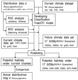
& Campbell 1993). 또한, 95%의 감도(Sensitivity) 일 경우 정의되어지는 출현확률을 역치로 적용하여 잠재 생육지(Potential habitats: PHs)로 판단하였 다(Tsuyama et al. 2011). 분포 변록지(Marginal habitats: MHs)는 생육 적지의 역치(閾値)보다 낮고 잠재 생육지의 분포확률 보다 높은 지역이며, 식물종 의 생육은 가능하지만 그다지 적합하지 않은 환경을 갖는 지역으로 판단하여 분석하였다. Figure 2는 본 연구에서 기후변화에 따른 사스레피나무의 잠재생육 지를 예측하기위한 분석 흐름도이다. 모델 해석 프로 그램으로는 R 2.11.1(R Development Core Team, 2011)을 사용하였다.
III. 결과 및 고찰
1. 모델구축 및 기후조건 분석
사스레피나무(Eurya japonica)의 분포자료와 기 후요소의 관계를 종분포 모델 중에 하나인 CT-
Figure 2. Flowchart of analysis. (Eja: Eurya japonica, CT- model; Classification tree model, GCMs: General Circulation Models)
model(Classification tree model)을 이용하여 사스 레피나무의 분포 모델(Eja-model)을 구축한 결과 총 6개의 terminal node(TN)가 생성되었다(Figure 3). 사스레피나무의 분포의 예측정도를 확인하기 위 해 ROC분석을 실시한 결과, AUC값이 0.90로 산출 되었으며, Swets(1988)의 모델 판정기준 AUC>0.8 에 의하면 good으로 판정되었다. ROC분석에서 모 델 적합도가 최고점일 경우의 분포확률을 역치(閾値) 로 한 값(MinROCdistance)은 0.180이며, 사스레피 나무의 분포 모델(Eja-model)에서 출현확률 0.180 이상의 지역을 생육적지(Suitable habitats)로 판단 하였다. 또한, 분포 재지점(在地点)의 95%를 포함 하는 최대 출현확률을 나타내는 분포확률 0.064이상 의 지역을 잠재 생육지(Potential habitats), 역치값 0.064~0.180의 지 역 을 분 포 변 록 지 (Marginal habitats)로 판단하여 분석하였다.
Eja-model의 구축 결과, 6개의 TN은 최한월최저 기온(TMC) -3.84℃를 기준으로 크게 제 1그룹(TN
①, TN②)과 제 2그룹(TN③~⑥)으로 나뉘어졌다.
제1그룹은 최한월최저기온(TMC) -5.73℃를 기준으 로 node ①과 node②로 구분되어지며, 제2그룹은 최한월최저기온(TMC) -2.51℃기준으로 node③와 node④~⑥로 구분되었다. 또한, 각 분기된 그룹은 기후요인에 의해 다시 분기되어 각 TN에 대한 기후 조건이 산출되었다.
한반도 사스레피나무의 분포와 기후요인에 대한 생 육적지(SHs)는 분포확률 0.180 이상의 지역으로 TN
③~⑥이며, 분포 변록지(MHs)는 분포확률 0.064~
0.180의 지역으로 TN②로 예측되었으며, 잠재 생육 지(생육적지와 분포 변록지)는 TN②~⑥의 5개 TN 으로 예측되었다. 구축된 Eja-model에서 가장 높은 출현확률을 나타내는 TN④의 기후조건은 -2.51℃≦
TMC<-1.54℃, PRW<640.5mm의 지역으로 예측되 었다. 그 다음으로 출현확률이 높은 TN⑤은 -2.51℃
≦TMC<-1.54℃, 640.5mm≦PRW의 기후조건이다.
분포 변록지로 판단되는 TN②의 기후조건은 -5.73℃
≦TMC<-3.84℃의 기후조건으로 분석되었다.
Eja-model의 구축시 terminal node(TN) 분리에 공헌한 독립변수의 분리공헌도(DWS: Deviance weighted score)는 TMC(최한월최저기온)가 99.2%, PRW(동계강수량)가 0.8%로 분석되었다. 따라서, 사스레피나무의 분포를 결정하는 제 1요인으로는 최 한월최저기온(TMC), 제 2요인으로는 동계강수량 (PRW)로 분석되었으며, 사스레피나무에 분포 영향 에 최한월최저기온(TMC)가 가장 큰 작용하고 있는 것으로 분석되었다.
2. 현재기후에서 생육지 예측
구축된 사스레피나무 분포 모델(Eja-model)을 토 대로 현재기후에서 사스레피나무의 잠재 생육지를 예측한 결과, 실제분포와 유사한 서남부 해안지역 및 남해안 지역과 울릉도, 제주도 내륙지역으로 예측되 었다(Figure 4).
사스레피나무의 생육적지 (TN③~⑥)는 서해안 도 Figure 3. Classification tree for E. japonica trees based
on the four climatic variables. Splitting conditions and probability of occurrence of E. japonica are shown at the first few major nodes. If the conditions shown at the top of a branch are met, follow the left branch, otherwise follow the right branch. resulting in 6 terminal nodes (TN). The length of the vertical lines below each true-false split corresponds to the change in the magnitude of deviance between parent and children nodes.
TMC: the minimum temperature of the coldest month, WI: warmth index, PRS: summer (May- September) precipitation. PRW: winter (December- March) precipitation. *Marginal habitats (MHs),
**Suitable habitats (SHs)
서지역의 위도, 서남부 내륙지역의 광주, 서남부 해 안지역의 장흥, 남해안의 순천, 고성, 동해 남동권 내 륙의 부산, 경주, 포항, 제주도, 울릉도의 해안내륙 지역으로 면적은 17,948km2로 예측되었다. 분포 변 록지(TN②)는 북한의 서해안지역 용연군, 옹진군 그 리고 남한의 서해안 백령도, 태안반도, 안면도, 서해 안 내륙지역의 전주, 고창, 담양, 남해안 지역의 진 주, 함안과 내륙지역의 대구, 동해남부권 내륙과 동 해중부해안의 울진, 고성으로 나타났으며 면적은
22,309km2로 예측되었다(Table 2). 현재기후에서 사스레피나무의 잠재 생육지(생육적지와 분포 변록 지)는 40,257km2로 한반도 면적의 약 12.1%를 차지 하였다(Table 2). 또한, 기후적으로는 생육가능하나 실제로 분포하고 있지 않는 생육지(Empty habitats) (Armonies & Reise 2003; Tsuyama et al. 2011)는 동해남부권 내륙과 동해중부해안의 울진, 고성지역 이 예측되었다(Figure 4). 이 지역은 사스레피나무의 분포 이동능력 등의 제한으로 실제로는 분포하고 있
Table 2. Comparison between the area of habitats E. japonica under the current climate and that under future climate scenarios of 17 GCMs(General Circulation Models) for 2050s and 2080
Climate condition Habitat type
Suitable habitats (km2) Maginal habitats (km2) Potential habitats (km2)
Current 17,948 22,309 40,257
Future 2050s 2080s 2050s 2080s 2050s 2080s
ACCESS1-0 55,339 88,410 42,616 51,278 97,955 139,688
BCC-CSM1-1 43,630 69,900 35,524 45,396 79,154 115,296
CCSM4 46,672 65,875 37,810 44,548 84,482 110,423
CNRM-CM5 41,389 66,109 39,192 49,230 80,581 115,339
GFDL-ESM2G 76,638 133,803 47,046 51,858 123,684 185,661
GISS-E2-R 53,447 72,554 40,973 42,072 94,420 114,626
Figure 4. Distribution of E. japonica in Korea. Map (A) shows the actual distribution, map (B) shows the potential habitats, suitable habitats, marginal habitats and empty habitats (A) Actual distribution (B) Current
지 않으나 기후적으로는 생육 가능한 지역으로 분석 되었다.
구축된 사스레피나무 분포모델(Eja-model)에서 사스레피나무의 잠재 생육지에 대한 온도와의 관계 에서 최한월최저기온(TMC)이 -5.7℃이상 지역으로 예측되었다. 제주도를 비롯한 남해안 일대에 분포하 는 난온대 상록활엽수 참식나무는 -4.41℃이상(Yun et al. 2014a), 후박나무는 -3.3℃ 이상 지역(Yun et al. 2011b)에서 잠재생육지 분포를 나타냄에 따라 사스레피나무는 후박나무, 참식나무에 비하여 내한 성이 높은 수종으로 현재기후에서 상대적으로 넓은 면적의 잠재생육지가 분포하는 것으로 판단된다.
3. 미래기후에서 생육지 예측
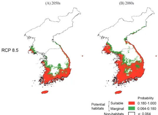
미래기후에서 사스레피나무의 생육지 변화를 예측 하기 위해 17개 미래기후 시나리오 RCP 8.5를 적용 하여 2050년(2040~2069)와 2080년(2070~2099) 의 시계열에 따른 잠재 생육지를 예측하였다.
미래기후 2050년의 잠재 생육지는 75,479~
126,895km2로 예측되었다(Table 2). 17개의 기후 시 나리오에서 예측된 잠재 생육지의 가능지역을 종합 하여 산출한 평균면적은 약 98,585km2이며 한반도 면적의 약 29.7%를 차지하였다(Table 2). 잠재 생육
지는 북한지역의 은율, 옹진 해안까지 예측되었으며, 남한 지역 내륙으로는 인천, 예산, 대전, 순천, 대구 등으로 예측되었다(Figure 5). 또한, 동부 지역으로 는 경주, 포항을 비롯하여 동해안 지역의 강릉, 속초, 고성과 북한지역의 원산까지 예측되었다(Figure 5).
미래기후 2050년에서 사스레피나무의 잠재 생육지 는 현재기후에서 보다 약 2.5배 증가된 면적으로 분 석되었다(Table 2).
미래기후 2080년에서 잠재 생육지는 90,472~
185,661km2로 예측되었다(Table 2). 17개 기후시나 리오에서 예측된 잠재 생육지의 가능지역을 종합하 여 산출한 평균면적은 약 135,500km2이며, 한반도 면적의 약 40.8%를 차지하였다. 잠재 생육지는 서해 안쪽으로 북한지역의 증산과 옹진반도 내륙, 사리원, 남한지역 내륙으로 서울, 청주, 문경, 봉화 등의 내륙 까지 예측되었으며, 동해안쪽으로는 경주, 포항, 울 진, 동해, 속초와 북한지역의 어대진까지 잠재 생육 지가 예측되었다(Figure 5). 미래기후 2080년의 사 스레피나무의 잠재 생육지는 현재기후에서 보다 약 3.4배 증가된 면적으로 분석되었다(Table 2).
IPCC에서 미래기후 시나리오의 불확실성에 대한 의견은 최소화하기 위하여 17개의 미래기후 시나리 오를 통해 예측된 기후변화에 따른 한반도 사스레피 Table 2. Continued
Climate condition Habitat type
Suitable habitats (km2) Maginal habitats (km2) Potential habitats (km2)
Current 17,948 22,309 40,257
Future 2050s 2080s 2050s 2080s 2050s 2080s
HadGEM2-AO 49,843 80,512 38,419 48,169 88,262 128,681
HadGEM2-ES 67,720 110,399 45,174 50,667 112,894 161,066
HadGEM2-CC 65,695 106,000 44,803 49,249 110,498 155,249
INMCM4 52,981 51,794 40,590 38,678 93,571 90,472
IPSL-CM5A-LR 67,948 91,559 43,291 44,250 111,239 135,809
MIROC5 53,496 81,228 40,628 40,149 94,124 121,377
MRI-CGCM3 39,914 109,801 35,565 39,234 75,479 149,035
MIROC-ESM-CHEM 84,801 114,663 42,094 46,744 126,895 161,407
MPI-ESM-LR 59,837 91,080 42,484 40,914 102,321 131,994
MIROC-ESM 68,193 113,241 43,381 49,153 111,574 162,394
NorESM1-M 48,756 78,789 40,063 46,197 88,819 124,986
Mean 54,353 89,748 41,156 45,752 98,585 135,500
나무의 분포를 평균하여 예측한 결과, 내륙으로 확대 와 북상 할 것으로 예측되었다. 따라서, 기후변화가 진행됨에 따라 남해안지역에 주로 분포하는 난온대 상록활엽림을 구성하는 사스레피나무는 난온대 및 냉온대 낙엽활엽수림으로 침입되는 과정에서 한반도 산림군락의 군락구조와 분포 변화 및 산림 생태계의 변화가 예상된다.
IV. 결 론
본 연구에서 한반도 사스레피나무의 생육을 결정 하는 기후조건과 잠재 생육지 분포 변화를 종분포 모 델을 이용하여 예측하였다. 또한, 전지구 기후모델에 의한 17개 미래기후 시나리오 RCP 8.5를 적용하여 기후변화가 한반도 사스레피나무의 분포에 미치는 영향을 분석하였다. 사스레피나무의 분포를 규정하 는 가장 큰 기후 요인으로는 최한월최저기온(TMC) 이며, -5.7℃이상 지역에서 분포하는 것으로 분석되 었다. 제 2요인으로는 동계강수량(PRW)로 분석되 었다.
기후변화에 따른 사스레피나무의 잠재 생육지는
현재기후에 비하여 미래기후 2050(2040~2069)년, 2080(2070~2099)년에서 각각 약 2.5배, 약 3.4배 증가하였으며, 점진적으로 확대 북상이 예상된다. 사 스레피나무는 한반도 기후변화에 주요한 식물 지표 종으로 유효하며, 잠재 생육지로 예측된 서해안 지역 및 남부 내륙의 저지대 등의 생육지역에 대하여 지속 적인 모니터링 조사가 필요할 것으로 판단된다. 종분 포 모델(SDMs)을 이용한 기후변화 식물 지표종의 유 효 검증과 현재기후 및 미래기후에서의 잠재 생육지 변화 예측은 모니터링 조사지역의 효과적인 선정과 기후변화에 따른 생육가능 지역을 평가하는데 중요 한 자료로 활용될 것으로 사료된다.
References
Armonies W, Reise K. 2003. Empty habitat in coastal sediments for populations of macrozoobenthos. Helgoland Mar Research.
56(4): 279-287.
Clark LA, Pregibon D. 1992. Tree-based models, In: J. M. Chambers and T. J. Hastie, eds.,
Figure 5. Distribution of potential habitats of E. japcconica for probabilities under the 17 GCMs (General Circulation Models) for 2050s and 2080.
(A) 2050s (B) 2080s
Statistical Models in S, California, Wadsworth
& Brooks/Cole Advanced Books & Software.
Pacific Grove: p. 377-419.
Berry PM, Dawson TP, Harrison PA, Pearson R, Butt N. 2003. The sensitivity and vulnerability of terrestrial habitats and species in Britain and Ireland to climate change. Journal of Nature Conservation. 11(1): 15-23.
Breiman L, Friedman JH, Olshen RA, Stone CJ.
1984. Classification and regression trees.
Chapman & Hall/CRC, Boca Raton, FL, US, pp 358.
Hanley J, McNeil B. 1982. The meaning and use of the area under areceiver operating characteristic (ROC) curve. Radiology.
143(1): 29-36.
Huntley B, Berry PM, Cramer W, McDonald AP.
1995. Modelling present and potential future ranges of some European higher plants using climate response surfaces.
Journal of Biogeography. 22(6): 967-1001.
Horikawa M, Tsuyama I, Matsui T, Kominami Y, Tanaka N. 2009. Assessing the potential impacts of climate change on the alpine habitat suitability of Japanese stone pine (Pinus pumila). Landscape Ecology. 24(1):
115-128.
IPCC 2014. Climate Change 2014: impacts, adaptation, and vulnerability. Part A: global and sectoral aspects. Contribution of Working Group II to the Fifth Assessment Report of the Intergovernmental Panel on Climate Change. Cambridge: Cambridge University.
Iverson LR, Prasad AM. 1998. Predicting abundance of 80 tree species following climate change in the eastern United States. Ecological Monographs. 68(4): 465- 485.
Kira T. 1977. A Climatological interpretation of
Japanese vegetation zones. In Miyawaki, A.
and Tuxen, R. (eds.) Vegetation science and environmental protection. Maruzen, Tokyo: p. 21-30.
Kumar P. 2012. Assessment of impact of climate change on Rondodendrons in Sikkim Himalayas using Maxent moddelling: limitations and changes. Biodiversity and Conservation.
21(5): 1251-1266.
Matsui T, Yagihashi T, Nakaya T, Tanaka N, Taoda H. 2004a. Climatic controls on distribution of Fagus crenata forests in Japan.
Journal of Vegetation Science. 15(1): 57-66.
Matsui T, Yagihashi T, Nakaya T, Taoda H, Yoshinaga S, Daimaru H, Tanaka N. 2004b.
Probability distributions, vulnerability and sensitivity in Fagus crenata forests following predicted climate changes in Japan. Journal of Vegetation Science. 15(5): 605-614.
Metz CE. 1978. Basic principles of ROC Analysis, Seminars in Nuclear Medicine. 8(4): 283-298.
Nakao K, Matsui T, Tanaka N. Hukusima T.
2009. Climatic controls of the distribution and abundance of two evergreen Quercus species in Japan. Japanese Journal of Forest Environment. 51(1): 27-37. [Japanese Literature]
Nakao K, Matsui T, Horikawa M, Tsuyama I, Tanaka N. 2011. Assessing the impact of land use and climate change on the evergreen broad-leaved species of Quercus acuta in Japan. Plant Ecology. 212(2): 229-243.
Nakao K, Higa M, Tsuyama I, Lin CT, Sun ST, Lin JR, Chiou CR, Chen TY, Matsui T.
Tanaka N. 2014. Changes in the potential habitats of 10 dominant evergreen broad- leaved tree species in the Taiwan-Japan archipelago. Plant Ecology. 215(6): 639-650.
Normand S, Svenning JC, Skov F. 2007. National
and European perspectives on climate change sensitivity of the habitats directive characteristic plant species. Journal for Nature Conservation. 15(1): 41-53.
Ohsawa M. 1990. An interpretation in latitudinal patterns of limits in south and east Asian mountains. Journal of Ecology. 78(2):
326-339.
Ohsawa M. 1991. Structural comparison of tropical mountain rain-forest along latitudinal and altitudinal gradients in south and east-Asia.
Vegetatio. 97: 1-10.
Ohsawa M. 1993. Latitudinal pattern of mountain vegetation zonation in southern and eastern Asia. Journal of Vegetation Science. 4(1):
13-18.
Parmesan C, Yohe G. 2003. A globally coherent fingerprint of climate change impacts across natural systems. Nature. 421: 37-42.
R Development Core Team. 2011. R: A language and environment for statistical computing, R. Foundation for Statistical Computing.
Vienna, Austria, ISBN 3-900051-07-0, URL://www.R-project.org.
Swets KA. 1988. Measuring the accuracy of diagnostic systems. Science. 240(4857):
1285-1293.
Tanaka N. 2007. PRDB (Phytosociological Releve Data Base), Environment change impact team. Forestry and Forest Products Research Institute.
Tanaka N, Nakazono E, Tsuyama I, Matsui T.
2009. Assessing impact of climate warming on potential habitats of ten conifer species in Japan. Global Environmental Research.
14(2): 153-164.
Thuiller W. 2003. BIOMOD-optimizing predictions of species distributions and projecting potential shifts under global change. Global Change
Biology. 9(10): 1353-1362.
Thuiller W. Lavorel S, Araujo MB, Sykes MT, Prentice IC. 2005. Climate Change threats to plant diversity in Europe. Proceeding of the National Academy of Sciences of the United States of America. 102(23): 8245- 8250.
Tsuyama I, Matsui T, Ogawa M, Kominami Y, Tanaka N. 2008. Habitat prediction and impact assessment of climate change on Sasa kurilensis in eastern Honshu, Japan.
Theory and Applications of GIS. 16(1):
11-25.〔Japanese Literature〕
Tsuyama I, Nakao K, Matsui T, Higa M, Horikawa M, Kominami Y, Tanaka N. 2011. Climatic controls of a keystone understory species, Sasamorpha borealis, and an impact assessment of climate change in Japan. Annals of Forest Science. 68(4): 689-699.
Uyeki H. 1941. On the northern limit of evergreen broad-leaved tree in Korea Acta. Phytotax.
Geobot. 10(2): 89-93. [Japanese Literature]
Yun JH, Kim JH, Oh KH, Lee BY. 2011a.
Distributional Change and Climate Condition of Warm-temperate Evergreen Broad-leaved Trees in Korea. Korean Journal of Environment and Ecology.
25(1): 47-56. [Korean Literature]
Yun JH, Nakao K, Park CH, Lee BY. 2011b.
Potential Habitats and Change Prediction of Machilus thunbergii Siebold & Zucc in Korea by Climate Change. Korean Journal of Environment and Ecology. 25(6): 903- 910. [Korean Literature]
Yun JH, Nakao K, Kim JH, Kim SY, Park CH, Lee BY. 2014a. Habitat prediction and impact assessment of Neolitsea sericea (Blume) Koidz. under Climate Change in Korea. Journal of Environmental Impact
Assessment. 23(2): 101-111. [Korean Literature]
Yun JH, Nakao K, Tsuyama I, Higa M, Matsui T, Park CH, Lee BY, Tanaka N. 2014b.
Does future climate change facilitate expansion of evergreen broad-leaved tree species in the human-disturbed landscape
of the Korean Peninsula? Implication for monitoring design of the impact assessment.
Japanese Forest Society. 19(1): 174-183.
Zweig MH, Campbell G. 1993. Receiver-operating characteristic (ROC) Plots: a fundamental evaluation tool in clinical medicine. Clinical Chemistry. 39(4): 561-577.