JPNT 4(2), 43-55 (2015)
http://dx.doi.org/10.11003/JPNT.2015.4.2.043
Copyright © The Korean GNSS Society
J PNT Journal of Positioning, Navigation, and Timing
http://www.gnss.or.kr Print ISSN: 2288-8187 Online ISSN: 2289-0866
1. INTRODUCTION
For the determination of user position based on a satellite navigation system, the possibility of positioning
Study on GNSS Constellation Combination to Improve the Current and Future Multi-GNSS Navigation Performance
Hyojeong Seok
1, Donghwan Yoon
1, Cheol Soon Lim
1, Byungwoon Park
1†, Seung-Woo Seo
2, Jun-Pyo Park
21Department of Aerospace Engineering, Sejong University, Seoul 143-747, Korea
2Agency for Defense Development, Daejeon 305-600, Korea
ABSTRACT
In the case of satellite navigation positioning, the shielding of satellite signals is determined by the environment of the region at which a user is located, and the navigation performance is determined accordingly. The accuracy of user position determination varies depending on the dilution of precision (DOP) which is a measuring index for the geometric characteristics of visible satellites; and if the minimum visible satellites are not secured, position determination is impossible.
Currently, the GLObal NAvigation Satellite system (GLONASS) of Russia is used to supplement the navigation performance of the Global Positioning System (GPS) in regions where GPS cannot be used. In addition, the European Satellite Navigation System (Galileo) of the European Union, the Chinese Satellite Navigation System (BeiDou) of China, the Quasi-Zenith Satellite System (QZSS) of Japan, and the Indian Regional Navigation Satellite System (IRNSS) of India are aimed to achieve the full operational capability (FOC) operation of the navigation system. Thus, the number of satellites available for navigation would rapidly increase, particularly in the Asian region; and when integrated navigation is performed, the improvement of navigation performance is expected to be much larger than that in other regions. To secure a stable and prompt position solution, GPS- GLONASS integrated navigation is generally performed at present. However, as available satellite navigation systems have been diversified, finding the minimum satellite constellation combination to obtain the best navigation performance has recently become an issue. For this purpose, it is necessary to examine and predict the navigation performance that could be obtained by the addition of the third satellite navigation system in addition to GPS-GLONASS. In this study, the current status of the integrated navigation performance for various satellite constellation combinations was analyzed based on 2014, and the navigation performance in 2020 was predicted based on the FOC plan of the satellite navigation system for each country.
For this prediction, the orbital elements and nominal almanac data of satellite navigation systems that can be observed in the Korean Peninsula were organized, and the minimum elevation angle expecting signal shielding was established based on Matlab and the performance was predicted in terms of DOP. In the case of integrated navigation, a time offset determination algorithm needs to be considered in order to estimate the clock error between navigation systems, and it was analyzed using two kinds of methods: a satellite navigation message based estimation method and a receiver based method where a user directly performs estimation. This simulation is expected to be used as an index for the establishment of the minimum satellite constellation for obtaining the best navigation performance.
Keywords: multi-constellation, cut-off angle, DOP simulation
is determined by the number of received signals, and the accuracy is affected by the geometric arrangement of satellites. Accordingly, the number and arrangement of visible satellites is a very important element. In the presence of signal blocking by geographic features as in downtown area, the time in which visible satellites are secured during a day is significantly limited when only GPS is used; while the visibility and accuracy could be improved when multi- constellation is organized by combining various satellite Received Jan 19, 2015 Revised Mar 02, 2015 Accepted Mar 16, 2015
†Corresponding Author E-mail: [email protected] Tel: +82-2-3408-4385 Fax: +82-2-3408-3333
44
JPNT 4(2), 43-55 (2015)http://dx.doi.org/10.11003/JPNT.2015.4.2.043
constellations. In particular, this prospect is gradually being implemented, as shown by the fact that the number of navigation satellites is expected to increase up to 150 by 2020. The GLONASS of Russia, which currently operates 24 satellites, is planning to operate 30 satellites in 2020, and the Galileo of Europe is also aimed to achieve the FOC of 30 satellites in 2020. In addition, the BeiDou of China, which is currently a regional navigation system, is aimed to establish a global navigation system that operates 35 satellites, in 2017;
and the IRNSS and QZSS are planning to operate seven and four satellites in 2016 and 2017, respectively. Therefore, the number of navigation satellites is expected to rapidly increase in the Asian region, so that it would be called ‘A Satellite Hotspot’, and it is drawing attention as a region where the effect of a multi-GNSS based positioning technique is the largest. For the improvement of navigation performance, and the stable and prompt determination of a position solution, GPS-GLONASS integrated navigation is generally performed at present. However, as available satellite navigation systems have been diversified in Korea, the necessity of finding the minimum satellite constellation combination for obtaining high navigation performance has been suggested.
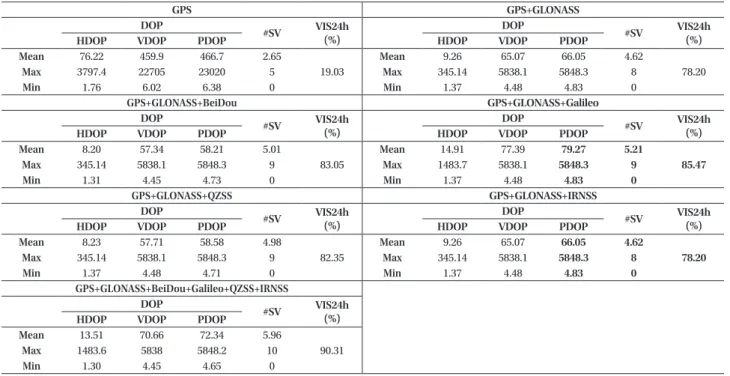
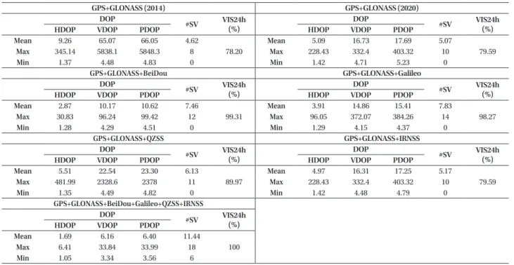
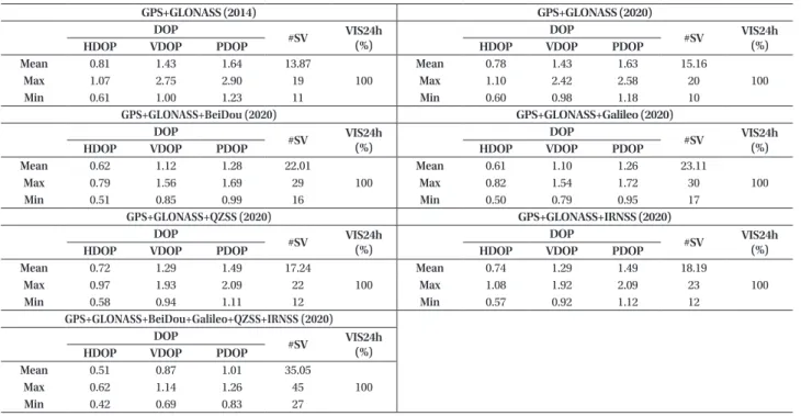
In this study, visibility analysis simulation was performed based on 2014 for GPS-only positioning, GPS-GLONASS integrated navigation, and integrated navigation using three satellite constellations through the addition of BeiDou, Galileo, QZSS, and IRNSS, respectively; and an optimal combination in the current situation was selected. Also, the same simulation was performed for 2020 when all the systems are expected to achieve FOC, and the navigation performances of each combination were compared and analyzed.
2. TREND AND ESTABLISHMENT PLAN FOR INTERNATIONAL SATELLITE NAVIGATION SYSTEMS
2.1 GPS
GPS is the most representative satellite navigation system, and it was developed with the purpose of the FOC operation of 24 medium earth orbit satellites on six orbital planes by arranging four satellites on each orbital plane at appropriate intervals. The FOC of 24 satellites was announced about 20 years ago; and through the continuous replacement of deteriorated satellites and the addition of new frequency, 32 stabilized satellites are in operation. In 2014, the satellite signals of 31 satellites could be normally received (Ha &
Chun 2010). Table 1 summarizes the nominal almanac data of the 24 GPS satellites, which are the initial design values,
and the latest almanac data of the 31 satellites, which are currently in service, can be obtained from the United States Coast Guard Navigation Center. Future modernization is expected to be focused on performance improvement rather than the increase in the number of satellites, and thus the almanac data of GPS used for the prediction were organized using the almanac information provided by the United States Coast Guard Navigation Center (The United States Coast Guard Navigation Center 2014).
2.2 GLONASS
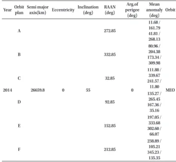
GLONASS is the satellite navigation system of the former Soviet Union and Russia, and it has been developed with the purpose of the operation of 30 medium earth orbit satellites (24 Operation and 6 Additional). Along with the modernization of GPS, a modernization plan for the performance improvement of GLONASS satellites has been continuously implemented since 2003. The representative contents of the modernization plan include changing the signal transmission method from FDMA to CDMA, adding various civilian signals, increasing the accuracy of position determination, and extending the life of satellites (Heo 2014). Russia is currently not suggesting a detailed launch plan, but they aim to launch six additional satellites for the second FOC. It is most likely that two satellites are launched to three planes where existing satellites are in operation, respectively (JSC M. F. RESHETNEV 2013). Table 2 summarizes the expected almanac data organized by predicting the launch schedule based on the fact that Russia aims to operate 30 satellites by 2020.
Year Orbit plan
Semi major
axis(km) Eccentricity Inclination (deg)
RAAN (deg)
Arg.of perigee (deg)
Mean anomaly
(deg) Orbit
2014 A
26659.8 0 55
272.85
0
11.68 / 161.79 41.81 / 268.13
MEO
B 332.85
80.96 / 204.38 173.34 /
309.98
C 32.85
111.88 / 339.67 241.57 /
11.80
D 92.85
135.27 / 265.45 167.36 /
35.16
E 152.85
197.05 / 333.68 302.60 /
66.07
F 212.85
238.89 / 105.21 345.23 /
135.35
Table 1. Nominal GPS orbit parameters.
Hyojeong Seok et al. Study on GNSS Constellation Combination
45
http://www.gnss.or.kr 2.3 BeiDou
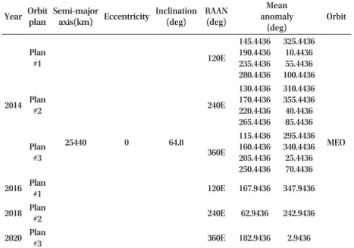
BeiDou is the satellite navigation system of China, and it has been developed with the purpose of the FOC of 35 satellites. The satellite configuration is composed of five geostationary orbit satellites, three inclined geosynchronous orbit satellites, and 27 medium earth orbit satellites. In the early stage, it was developed as a regional navigation system, but it will be converted to a navigation system that is aimed at global service. The development of BeiDou is divided into three phases (Phase 1, Phase 2, and Phase 3), and up to Phase 2 has been completed as of 2014. Originally, China planned to complete the establishment of a global satellite navigation system by 2020 (Heo 2014). However, in the ‘China Satellite Navigation Conference (CSNS 2014)’, they advanced the existing plan and announced that the FOC is expected in 2017 ~ 2018 (INSIDE GNSS 2014). Table 3 summarizes the nominal almanac data and expected launch schedule for BeiDou. In the case of BeiDou, a total of 16 satellites (six GEO satellites, five IGSO satellites, and five MEO satellites) including two spare satellites have been launched until Phase 2; and among them, 14 satellites are in service (INSIDE GNSS 2013). Therefore, additional launch of 23 MEO satellites is expected in Phase 3 where the conversion from a regional navigation system to a global satellite navigation system is implemented. The expected almanac data were organized using the expected FOC year of 2018 based on China’s announcement of advancing the FOC from 2020 to 2017 ~ 2018 and based on the orbital elements of the 35 satellites provided by China (China Satellite Navigation Office 2010).
2.4 QZSS
QZSS, which has been developed and operated by the
Japan Aerospace Exploration Agency (JAXA), is a Regional Navigation Satellite System (RNSS) that provides service to Japan. Four satellites are expected to first provide official service from 2018 with the purpose of the establishment of an independent navigation system by the FOC operation of seven satellites (Murai 2014, Heo 2014). The configuration of the four satellites, whose detailed plan has been provided so far, includes three IGSO (HEO) satellites and one GEO satellite. The plan and information for the remaining three satellites have not been specified, and thus the operation of only the four satellites was considered in this study.
This system has been developed in cooperation with the United States with the purpose of securing visible satellites in downtown area. It has a high availability (99%) within Table 2. GLONASS orbit parameters.
YearOrbit plan
Semi-major
axis(km) Eccentricity Inclination (deg)
RAAN (deg)
Mean anomaly
(deg)
Orbit
2014 Plan
#1
25440 0 64.8
120E 145.4436 190.4436 235.4436 280.4436
325.4436 10.4436 55.4436 100.4436
MEO Plan
#2 240E
130.4436 170.4436 220.4436 265.4436
310.4436 355.4436 40.4436 85.4436
Plan
#3 360E
115.4436 160.4436 205.4436 250.4436
295.4436 340.4436 25.4436 70.4436 2016 Plan
#1 120E 167.9436 347.9436
2018 Plan
#2 240E 62.9436 242.9436
2020 Plan
#3 360E 182.9436 2.9436
Table 3. BeiDou orbit parameters.
Year SV # Semi-major
axis (km) Eccentricity Inclination (deg)
RAAN (deg)
Arg. of perigee (deg)
Mean anomaly
(deg) Orbit
2014 1
42164
0 0
158.75E 180E 210.5E
240E 260E
0
0 GEO
2 3 4 5 6
55 218E
98E 338E
0 120 240
IGSO 7
8 12
27878
218E 0
40
MEO 16
22 98E 0
26 40
2015
9 218E 80
10 120
21 98E 80
23 120
32 338E 0
33 40
2016
11 218E 160
13 200
24 98E 160
25 200
34 338E 80
35 120
2017 14
218E
240 280 320 15
17 27
338E
160 200 240 28
29
2018 18
98E
240 280 320 19
20
2018 30 280
31 320
Table 4. QZSS orbit parameters.
Year SV #Semi-major
axis (km) EccentricityInclination (deg)
RAAN (deg)
Arg. of perigee (deg)
Central longitude of
ground track(deg)
Orbit
2014 1
42164 0.099 45
80.09E
270E 135 IGSO
(HEO)
2016 2 208.03E
3 328.09E
2017 4 0 0 245E 91.753E 127 GEO
46
JPNT 4(2), 43-55 (2015)http://dx.doi.org/10.11003/JPNT.2015.4.2.043
Japan, and the position accuracy is also outstanding when combined with GPS (Yoo et al. 2008). Table 4 summarizes the nominal almanac data and expected launch schedule of the four QZSS satellites that are expected to provide service first. A detailed plan has not been provided regarding which orbital satellites will be launched in the corresponding year, and thus the launch schedule was predicted based on 2017 which is the expected FOC year of QZSS. Also, for the orbital elements of the GEO satellite where detailed information has not been provided, the expected almanac data were organized based on the orbital elements of a general GEO satellite and the orbital elements of the navigation systems that launch GEO satellites (BeiDou and IRNSS).
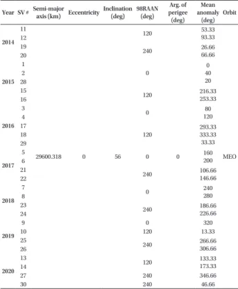
2.5 Galileo
Galileo is aimed to achieve the FOC of 30 medium earth orbit satellites in 2020 by the European Space Agency (ESA), and to provide 4 ~ 8 m level position accuracy around the globe through open service (Ha & Chun 2010). Table 5 summarizes the nominal almanac data and expected launch schedule for Galileo. The final objective of Galileo is the FOC operation of 30 satellites. ESA is expected to select the detailed orbital elements of three additional (spare) satellites after the completion of the launch of 27 satellites and the examination of the operation status, and they have provided
the nominal almanac data of the 27 satellites. The Galileo satellite launch schedule provided earlier has low reliability due to the frequent change of the development plan and the delay of the launch schedule. Also, as ESA is currently not providing a detailed satellite launch schedule, the detailed launch schedule of Galileo cannot be drawn yet. Therefore, the launch schedule was predicted based on 2020 which is the expected FOC year. Also, for the three spare satellites where ESA has not provided detailed nominal almanac data, it is expected that the satellites will be additionally launched to three planes where satellites are currently in operation, without adding a new orbital plane. Thus, the expected nominal almanac data were organized based on this (European GNSS Service Centre; http://www.gsc-europa.eu).
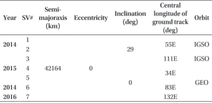
2.6 IRNSS
IRNSS is the regional navigation system of India, and it has been developed for the operation of a total of seven satellites (four inclined geosynchronous orbit satellites and three geostationary orbit satellites) with the purpose of achieving FOC in early 2016. The range of the service region of IRNSS is 30oS ~ 50oN latitude and 30oE ~ 130oE longitude, and the Korean Peninsula, which is 33oN ~ 43oN latitude and 124oE ~ 132oE longitude, is completely included in the service region of IRNSS. In the case of IRNSS, a total of three satellites (two inclined geosynchronous orbit satellites and one geostationary orbit satellite) have been launched as of 2014. The Indian Space Research Organisation (ISRO; http://isro.gov.in/), which is the IRNSS operation institution, has not provided the satellite launch order and detailed launch schedule, but the exp.ected almanac data were organized based on 2016 which is the expected FOC year, as summarized in Table 6 (ISRO).
2.7 Synthesis of the Plans for the Establishment of International Satellite Navigation Systems
According to the trend in the navigation satellite launch for each country until 2014, two to three satellites that are operated on the same orbital plane have been launched together to reduce the launch cost. Table 7 summarizes the synthesized plans for the establishment of the satellite navigation systems for each country predicted in each year by collecting the navigation satellite launch schedule for each country and by reflecting the expected launch schedule and launch trend based on the ‘Satellite on the Net’ and ‘Space Calendar’ which present the launch schedules of navigation satellites and space launch vehicles (Satellite on the Net 2014, NASA Spaceflight.com 2014, Spaceflight Now 2015).
Table 5. Galileo orbit parameters.
Year SV # Semi-major
axis (km) EccentricityInclination (deg)
98RAAN (deg)
Arg. of perigee (deg)
Mean anomaly
(deg) Orbit
2014 11
29600.318 0 56
120
0
53.33 93.33
MEO 12
19 240 26.66
66.66 20
2015 1
0
0 40 20 2
28
15 120 216.33
253.33 16
2016
3 0 80
4 120 17
120
293.33 333.33 33.33 18
29 2017
5 0 160
6 200
21 240 106.66
146.66 22
2018
7 0 240
8 280
23 240 186.66
226.66 24
2019
9 0 320
10 120 13.33
25 240 266.66
306.66 26
2020
13 120 133.33
173.33 14
27 240 346.66
30 240 46.66
Hyojeong Seok et al. Study on GNSS Constellation Combination
47
http://www.gnss.or.kr
3. VISIBILITY ANALYSIS ALGORITHM
The position information of satellites for the current status analysis of navigation performance and the simulation for the prediction of navigation performance in 2020 was drawn using the almanac information of each satellite constellation. For satellites that are planned to be launched and have not been launched yet, the establishment plan of navigation satellites for each country was reflected using the nominal almanac information that had been suggested as the design values by the official operation institution for each country. Then, the expected almanac data were organized and reflected in the prediction of performance in 2020. By applying the minimum elevation angle expecting satellite signal shielding and the elevation angle for each satellite obtained using the satellite almanac to Eq. (1), the visibility of the corresponding satellite is determined.
EIcutoff > EIs (1)
where EIcutoff is the minimum elevation angle reflecting the shielding of satellite signals, and EIs is the elevation angle of the satellite. When the elevation angle of the satellite is lower than the minimum elevation angle, it is judged as a non- visible satellite from which a user cannot receive satellite signals; and otherwise, it is judged as a visible satellite.
After the extraction of visible satellites, user position and clock error are calculated by navigation equations.
In the case of multi-constellation, the reference times for each system are different, and thus their measurements include different clock errors. To resolve this, a method that reflects the difference using the information provided by the satellite navigation message and a method in which the clock error for each satellite navigation system is directly estimated in a receiver are generally used (Joo et al. 2012).
In the first method, each measurement can be synchronized with the GPS time using the offset information from GPSTime included in the navigation message (e.g., Galileo and BeiDou).
The measurement of the GPS satellite i in the GPSTime frame can be simply expressed as Eq. (2).
the expected almanac data were organized based on 2016 which is the expected FOC year, as summarized in Table 6 (ISRO).
2.7 Synthesis of the Plans for the Establishment of International Satellite Navigation Systems According to the trend in the navigation satellite launch for each country until 2014, two to three satellites that are operated on the same orbital plane have been launched together to reduce the launch cost. Table 7 summarizes the synthesized plans for the establishment of the satellite navigation systems for each country predicted in each year by collecting the navigation satellite launch schedule for each country and by reflecting the expected launch schedule and launch trend based on the ‘Satellite on the Net’ and ‘Space Calendar’ which present the launch schedules of navigation satellites and space launch vehicles (Satellite on the Net 2014, NASA Spaceflight.com 2014, Spaceflight Now 2015).
3. VISIBILITY ANALYSIS ALGORITHM
The position information of satellites for the current status analysis of navigation performance and the simulation for the prediction of navigation performance in 2020 was drawn using the almanac information of each satellite constellation. For satellites that are planned to be launched and have not been launched yet, the establishment plan of navigation satellites for each country was reflected using the nominal almanac information that had been suggested as the design values by the official operation institution for each country. Then, the expected almanac data were organized and reflected in the prediction of performance in 2020. By applying the minimum elevation angle expecting satellite signal shielding and the elevation angle for each satellite obtained using the satellite almanac to Eq. (1), the visibility of the corresponding satellite is determined.
(1) where EIcutoff is the minimum elevation angle reflecting the shielding of satellite signals, and EIs is the elevation angle of the satellite. When the elevation angle of the satellite is lower than the minimum elevation angle, it is judged as a non-visible satellite from which a user cannot receive satellite signals; and otherwise, it is judged as a visible satellite.
After the extraction of visible satellites, user position and clock error are calculated by navigation equations. In the case of multi-constellation, the reference times for each system are different, and thus their measurements include different clock errors. To resolve this, a method that reflects the difference using the information provided by the satellite navigation message and a method in which the clock error for each satellite navigation system is directly estimated in a receiver are generally used (Joo et al. 2012).
In the first method, each measurement can be synchronized with the GPS time using the offset information from GPSTime included in the navigation message (e.g., Galileo and BeiDou).
The measurement of the GPS satellite i in the GPSTime frame can be simply expressed as Eq. (2).
i GPS GPST
iGPS,
d B
(2)s cutoff
El El
(2)
where
d : Measurement excluding the receiver clock error BGPS : GPS clock error
GPST : GPSTime frame
Similar to Eq. (2), the measurement in the XTime frame for the satellite j of the GNSS system X other than GPS can be expressed as Eq. (3).
where
d: Measurement excluding the receiver clock error BGPS: GPS clock error
GPST : GPSTime frame
Similar to Eq. (2), the measurement in the XTime frame for the satellite j of the GNSS system X other than GPS can be expressed as Eq. (3).
j X XT
jX,
d B
(3) whereBX: Clock error of the system X XT : GNSS XTime frame
In this regard, BGXTO, which is the receiver clock error difference between GPS and GNSS X by the GPS-X Time Offset (GXTO), can be expressed as Eq. (4).
GPS X
GXTO B B
B
(4)GPST
X , , which is the measurement of the GNSS system X in the GPSTime frame, can be expressed as Eq. (5), and this indicates the time synchronization between GPS and the system X.GXTO XT X GPST
X,
,
B
(5)The application of the GPS-Galileo Time Offset estimated using navigation message at an accuracy of about 2.5 ns showed that the Horizontal Precision Error (HEPg) was about 42.7 m and the Vertical Precision Error (VEPg) was 143.1 m, indicating that the performance deteriorated. Also, when the accuracy was about 16 ns, the HEPg was 51.4 m and the VEPg was 179 m, indicating that the performance deteriorated significantly. Thus, it was found that the performance of the time offset estimation between the systems had a significant effect on the multi-constellation positioning performance However, when the measurement X is synchronized with the GPSTime frame as mentioned above, the observation matrix is identical to that of single satellite navigation, and thus positioning is enabled with only more than four visible satellites regardless of the type of satellite navigation systems (INSIDE GNSS 2007). Therefore, it would be mostly used for positioning in downtown area where the possibility of positioning with a small number of satellites is important rather than positioning performance (e.g., accuracy); and in this study, this was classified as a method that is applied to ‘coarse positioning’.
The above process can be organized using equations, as shown in Eq. (6).
cp cp cp
cp H x
z
(6) where(3)
where
BX : Clock error of the system X TX : GNSS XTime frame
In this regard, BGXTO, which is the receiver clock error difference between GPS and GNSS X by the GPS-X Time Offset (GXTO), can be expressed as Eq. (4).
where
d: Measurement excluding the receiver clock error BGPS: GPS clock error
GPST : GPSTime frame
Similar to Eq. (2), the measurement in the XTime frame for the satellite j of the GNSS system X other than GPS can be expressed as Eq. (3).
j X XT
jX,
d B
(3) whereBX: Clock error of the system X XT : GNSS XTime frame
In this regard, BGXTO, which is the receiver clock error difference between GPS and GNSS X by the GPS-X Time Offset (GXTO), can be expressed as Eq. (4).
GPS X
GXTO B B
B
(4)GPST
X , , which is the measurement of the GNSS system X in the GPSTime frame, can be expressed as Eq. (5), and this indicates the time synchronization between GPS and the system X.GXTO XT X GPST
X,
,
B
(5)The application of the GPS-Galileo Time Offset estimated using navigation message at an accuracy of about 2.5 ns showed that the Horizontal Precision Error (HEPg) was about 42.7 m and the Vertical Precision Error (VEPg) was 143.1 m, indicating that the performance deteriorated. Also, when the accuracy was about 16 ns, the HEPg was 51.4 m and the VEPg was 179 m, indicating that the performance deteriorated significantly. Thus, it was found that the performance of the time offset estimation between the systems had a significant effect on the multi-constellation positioning performance However, when the measurement X is synchronized with the GPSTime frame as mentioned above, the observation matrix is identical to that of single satellite navigation, and thus positioning is enabled with only more than four visible satellites regardless of the type of satellite navigation systems (INSIDE GNSS 2007). Therefore, it would be mostly used for positioning in downtown area where the possibility of positioning with a small number of satellites is important rather than positioning performance (e.g., accuracy); and in this study, this was classified as a method that is applied to ‘coarse positioning’.
The above process can be organized using equations, as shown in Eq. (6).
cp cp cp
cp H x
z
(6) where(4) where
d: Measurement excluding the receiver clock error BGPS: GPS clock error
GPST : GPSTime frame
Similar to Eq. (2), the measurement in the XTime frame for the satellite j of the GNSS system X other than GPS can be expressed as Eq. (3).
j X XT
jX,
d B
(3) whereBX: Clock error of the system X XT : GNSS XTime frame
In this regard, BGXTO, which is the receiver clock error difference between GPS and GNSS X by the GPS-X Time Offset (GXTO), can be expressed as Eq. (4).
GPS X
GXTO B B
B
(4)GPST
X , , which is the measurement of the GNSS system X in the GPSTime frame, can be expressed as Eq. (5), and this indicates the time synchronization between GPS and the system X.GXTO XT X GPST
X,
,
B
(5)The application of the GPS-Galileo Time Offset estimated using navigation message at an accuracy of about 2.5 ns showed that the Horizontal Precision Error (HEPg) was about 42.7 m and the Vertical Precision Error (VEPg) was 143.1 m, indicating that the performance deteriorated. Also, when the accuracy was about 16 ns, the HEPg was 51.4 m and the VEPg was 179 m, indicating that the performance deteriorated significantly. Thus, it was found that the performance of the time offset estimation between the systems had a significant effect on the multi-constellation positioning performance However, when the measurement X is synchronized with the GPSTime frame as mentioned above, the observation matrix is identical to that of single satellite navigation, and thus positioning is enabled with only more than four visible satellites regardless of the type of satellite navigation systems (INSIDE GNSS 2007). Therefore, it would be mostly used for positioning in downtown area where the possibility of positioning with a small number of satellites is important rather than positioning performance (e.g., accuracy); and in this study, this was classified as a method that is applied to ‘coarse positioning’.
The above process can be organized using equations, as shown in Eq. (6).
cp cp cp
cp H x
z
(6) where,GPST, which is the measurement of the GNSS system X in the GPSTime frame, can be expressed as Eq. (5), and this indicates the time synchronization between GPS and the system X.
where
d: Measurement excluding the receiver clock error BGPS: GPS clock error
GPST : GPSTime frame
Similar to Eq. (2), the measurement in the XTime frame for the satellite j of the GNSS system X other than GPS can be expressed as Eq. (3).
j X XT
jX,
d B
(3) whereBX: Clock error of the system X XT : GNSS XTime frame
In this regard, BGXTO, which is the receiver clock error difference between GPS and GNSS X by the GPS-X Time Offset (GXTO), can be expressed as Eq. (4).
GPS X
GXTO B B
B
(4)GPST
X , , which is the measurement of the GNSS system X in the GPSTime frame, can be expressed as Eq. (5), and this indicates the time synchronization between GPS and the system X.GXTO XT X GPST
X,
,
B
(5)The application of the GPS-Galileo Time Offset estimated using navigation message at an accuracy of about 2.5 ns showed that the Horizontal Precision Error (HEPg) was about 42.7 m and the Vertical Precision Error (VEPg) was 143.1 m, indicating that the performance deteriorated. Also, when the accuracy was about 16 ns, the HEPg was 51.4 m and the VEPg was 179 m, indicating that the performance deteriorated significantly. Thus, it was found that the performance of the time offset estimation between the systems had a significant effect on the multi-constellation positioning performance However, when the measurement X is synchronized with the GPSTime frame as mentioned above, the observation matrix is identical to that of single satellite navigation, and thus positioning is enabled with only more than four visible satellites regardless of the type of satellite navigation systems (INSIDE GNSS 2007). Therefore, it would be mostly used for positioning in downtown area where the possibility of positioning with a small number of satellites is important rather than positioning performance (e.g., accuracy); and in this study, this was classified as a method that is applied to ‘coarse positioning’.
The above process can be organized using equations, as shown in Eq. (6).
cp cp cp
cp H x
z
(6) where(5)
The application of the GPS-Galileo Time Offset estimated using navigation message at an accuracy of about 2.5 ns showed that the Horizontal Precision Error (HEPg) was about 42.7 m and the Vertical Precision Error Table 6. IRNSS orbit parameters.
Year SV#
Semi- majoraxis
(km) Eccentricity Inclination (deg)
Central longitude of ground track
(deg)
Orbit
2014 1
42164 0
29 55E IGSO
2
2015
3 111E IGSO
4
0
34E 5 GEO
2014 6 83E
2016 7 132E
Table 7. Assumption of GNSS launch plan.
GPS GLONASS BeiDou Galileo QZS IRNSS Total
2014 Current 31 24 14(16) 4 1 2 79
2015 Current New launch
18 6
10 6
5
3 89
2016 Current New launch
26 2
24 6
14 4
2 1
7
2 104
2017 Current New launch
30 6
18 4
4
2 116
2018 Current New launch
28 2
35 5
22
4 127
2019 Current New launch
26
4 131
2020 Current New launch
30 2
30
4 137