Temperature Change Analysis for Land Use Zoning Using Landsat Satellite Imagery
전체 글
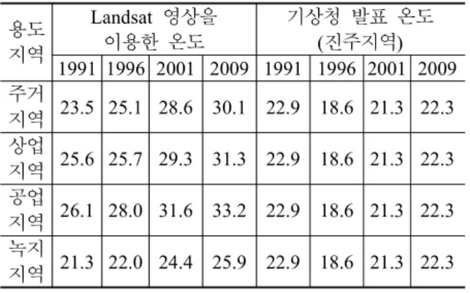
수치
관련 문서
Second, as a direct impact, the abolishing of licensing gives both incumbent and entrants higher option value directly because the new facility based
• 이명의 치료에 대한 매커니즘과 디지털 음향 기술에 대한 상업적으로의 급속한 발전으로 인해 치료 옵션은 증가했 지만, 선택 가이드 라인은 거의 없음.. •
If the volume of the system is increased at constant temperature, there should be no change in internal energy: since temperature remains constant, the kinetic
1 John Owen, Justification by Faith Alone, in The Works of John Owen, ed. John Bolt, trans. Scott Clark, "Do This and Live: Christ's Active Obedience as the
In order to analyze thermal stability and capacity loss according to the temperature of the battery cell by applying different C-rate discharge and
The data are corrected for temperature error due to solar radiation and the effect of low temperature on the anerod capsule and curvature of the surface of
The feature of the highest temperature is that temperature fluctuation is sharpest in the winter and spring when the change of barometer is big because of
As a result of comparing with the temperature change, the coldest month mean temperature (January, February, December) showed positive value in the whole
