태양극대기 대비 위성통신망에 관한 재난안전관리시스템에 관한 연구
오종우* 정회원
A Study of the Disaster Safety Management Systems on the Satellite Communication Networks for Solar Maximum
Jongwoo Oh* Regular Members
요 약
본 연구는 2013년 우주기상 극대기에 가시화 될 수 있는 재난에 대한 대응방안을 제시하고자 한다. 우주기상 극대기는 지구상에 크나큰 재앙을 초래할 것으로 예견되고 있다. 특히 근년에 들어 지자기 폭풍에 의한 손상과 가시화 될 수 있는 조짐을 보이고 있다.
그럼에도 불구하고 정부와 학계에서는 태양폭풍의 피해우려에 따른 분야별 우주통신과 지상통신망에 대한 워닝시스템 중심으로 규명되고 있을 뿐 우주기상 폭풍 대비 관리 및 운영시스템이 현실적으로 부재하다. 본 연구에서는 이상에서 제시된 문제점에 대한 피해분석에 따른 궁극적인 우주기상 통신망에 대한 피해 저감 대비방안을 제시하였다. 구현방법으로는 GIS기반 우주기상극대기 대 비 통신망피해관리시스템 구현은 우주폭풍에서 방사되는 우주복사폭풍(flare), 우주입자폭풍(solar proton event), 우주자기폭풍 (geomagnetic storm) 등에 대한 지자기권 및 이온권과 지상권의 분야별 폭풍피해를 분석하여 유형별 전파피해 대응방안에 대비할 수 있도록 하였다. 이로서 공간정보기반의 우주폭풍 통신망 피해대비 운영관리시스템 구현은 GIS기법에 의한 의사결정지원시스템 으로 피해예측 및 방재환경을 스마트 IT환경과 융합한 첨단 정보시스템으로 구현하여 인명과 재산을 보전할 수 있는 수단으로 기여 될 수 있을 것이다.
키워드 : 공간정보, GIS기법, 태양극대기, 위성통신망, 우주기상정보시스템, 의사결정지원체계
ABSTRACT
This paper takes precautions proposals against prospective disasters from the space weather maximum in 2013. The space weather maximum could wreak havoc in this world. A geomagnetic space storm sparked by a solar eruption like the one that flared toward earth is bound to strike again and could wreak havoc across the modern world. Despite of the fact that not only researches by colleges and institutions current researches have been focusing on warning systems of space communication and the earth network systems, but also management and control systems are not situated for the space weather blasters. The purpose of the study is that the damage reduces methods implementation on the ultimate space weather communication systems by above lists proposed type analysis. In result, the implementation of the communication disaster management systems deals with the smart IT converged GIS analysis on the flare, solar proton event, geomagnetic storm to the effects of the geomagneticsphere, ionosphere and troposphere from solar maximum. This research can provide affective methods for the saving lives and property protections that implementation of the disaster prediction and disaster prevention systems adapts smart IT systems and converged high tech information systems using decision making support systems of the GIS methodology.
Key Words : Spatial information, GIS methods, space weather maximum, satellite communications, space weather information systems, decision making support systems
*남서울대학교 GIS공학과, 스페이스웨더정보연구소 ([email protected]),
접수일자 : 2012년 11월 19일, 수정완료일자 : 2012년 11월 22일, 최종게재확정일자 : 2012년 12월 3일
I. Overview of Space Weather
The situation of a solar eruption will only get more dire
disasters[19] than any others because the solar cycle is heading into a period of more intense activity in the coming 11 years that turns around in 2013(Fig 1). The last
time a solar storm was a maximum in the solar cycle about 10BP. Many scientific advantages that we take for granted today are so much more prone to the process of space weather than that are the case in the last solar maximum [5,7,8].
Fig 1. Solar maximum cycle from 1996-2013. Source:
NOAA : National Oceanic and Atmospheric Administration
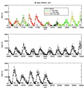
There are unique records of the astronomical phenomena over the 2000 years by China and Korea in the world. Fluctuation of solar sunspots confirmed average 11.2 year cycle by telescope of Galileo Galilei in 1609(Fig 3)[1,2]. After this finding the sunspot numbers used for the standard index of the solar activity cycles: 1st cycle of the solar activity cycles was 1755 through 1766, and current cycle is applicable to the 24th solar activity cycle.
Fig 2. Solar Storm forces to the earth geomagnecticsphere.
Source: NASA의 'ACE(Advanced Composition Explorer)' Previous Studies
Space storms historically exhibited on the written statement, such as Koryo history (an ancient Korean state: 918-1392)[1,2,15]. Sun spots observed since 1760 that counted by international sunspot numbers and NOAA sunspot numbers[2] (Fig 4). Under the scientific record the first major solar flare was recorded by British astronomer Richard Carrington in 1859. Other solar geomagnetic storms have been observed in recent decades using solar explore satellites named ‘Soho ‘ in 1995 (Fig 3) that along with various space weather institutes around the world, such as NWS(SWPC) in USA, ESA in EU, IPS in Australia, and NICT(JAXA) in Japan[13].
Fig 3. Sun Spots since 1760 counted by International Sunspot Number and NOAA sunspot number
Disasters from Space Weather by a Solar Eruption as follow, one huge solar flare in 1972 shut out long-distance telephone communication in the midwest state of Illinois (NASA). Another similar flare in 1989 was provoked geomagnetic storms that disrupted electric power transmission and caused blackouts across the Canadian province of Quebec[5]. A panel of NASA-assembled scientists issued a report in 2009 that recorded a powerful solar flare could overwhelm high-voltage transformers with electrical currents and short-circuit energy grids.
Such a catastrophic event could cost the United States alone up to two trillion dollars in repairs in the first year-and it could take up to 10 years to fully recover [16].
II. Disasters from the Solar Maximum
The sun blast is getting steeper increase to solar maximum of the space weather in 2013, such as CME and sunspot (Fig. 4). Despite of the fact that not only researches by colleges and institutions current researches have been focusing on warning systems of space communication and the earth network systems, but also management and control systems are not situated for the space weather blasters[6].
An environmental alteration of the spatial information on spatially existing space weather affects partial and safety problems to spacecrafts, satellite communication,
GPS and northpole aviations. Nevertheless GIS based space weather network management and operating systems are not properly implemented by the spatial information treatment methods. There are necessary that the spatial information based GIS implementation by this problems that guide to the server disaster situations, and by damages, losses, damages and ripple effects throughout the various kinds, massive and common high scientific electric networks[11,12].
The disaster reducing research fields of the space blasters on the communication networks are four kinds:
The 4-D distribution mapping on network disasters, special DB construction systems on network disasters distribution, GIS system implementation on operation and management, and decision making support system implementation for network management and operations.
4-1. Sun flare
4-2. Sunspot by eruption
Fig 4. Solar flare with corona and eruption as a sunsppot (NASA ACE Satellite)
1. Satellite Communication Devices Broke out
The study is that of the damage reduces methods implementation on the ultimate space weather communication systems by above lists proposed type analysis. The process methods of the study are that an implementation of preparation for the communication disaster management systems of the GIS based on solar maximum deal with analysis on the flare, solar proton
event, geomagnetic storm from space blasters, so that the pattern radio wave disasters for the protection and preparation methods[15].
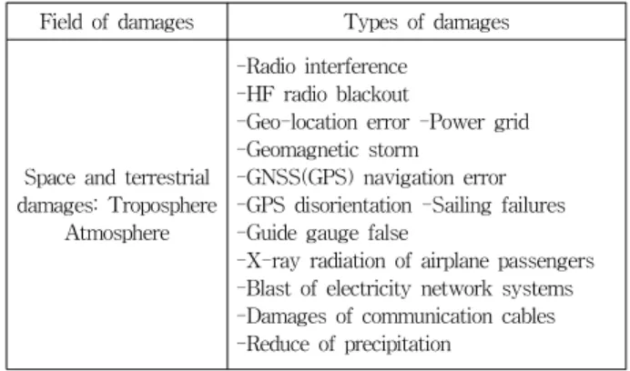
In addition, a study on GIS based implementation of the communication networks disaster management systems for solar maximum can provide multiple dimension distribution maps on the ground distributed electric and electricity producing systems and transportation with usage facilities (table 1). Therefore, implementation of the spatial information based space blast communication disaster for operational management systems can be solved by the decision making support systems of GIS techniques. This research can provide affective methods for the saving lives and property protections that implementation of the disaster prediction and disaster prevention systems adapts smart IT systems and converged high tech information systems using GIS methodology[10].
Fig 5. Damages of satellite systems and ground communication systems from solar blast with geomagnetic flare and ionosphere eruptions
Table 1. Damage types of Space communication systems by space weather
Field of damages Types of damages
Space and terrestrial damages: Troposphere
Atmosphere
-Radio interference -HF radio blackout
-Geo-location error -Power grid -Geomagnetic storm
-GNSS(GPS) navigation error -GPS disorientation -Sailing failures -Guide gauge false
-X-ray radiation of airplane passengers -Blast of electricity network systems -Damages of communication cables -Reduce of precipitation
2. Radiation effects to Organism
Solar radiation effects to the Organism that has been
experimented at the laboratory [19]. It is a very serious result from the excessive solar radiation and particles to the human bodies rather than that of exposed by x-ray at the hospitals. The solar radiation to the human bodies will not only be damaged to DNA from the cells, but also will seriously be malfunctionated on cancer generations, informal birth, and even sudden deaths(table 2)(Fig 6)[18].
Table 2. Malfunctioned Cells by space weather radiations Damaged
Factors Examples of Defunctionated Cells
Power of Radiations
•High frequency radiation with speedy particles composes to cells that adequate energy may generate to electron from molecule when it be ionized original cell functions that will be destroyed.
•The most critical damage of cells when DNA(Deoxyribo Nucleic Acid)
Two damages of radiations by driving force fof DNA in
cells
•Internal body moisture absorbs ionoized water that may damage to body when the DNA molecule reacted with
•The radiation itself conflicts to the DNA molecule that ionized as forcing damages
Illness symtoms by
radiations
•Recovery delayed heavy burn, sterility, cancer and other organs damage
•Heavy radiation to the body may die within few days or few weeks
•Change of mutation or DNA is hereditary to the offspring
•: Source: RRA; National Radio Research Center(KSWC; Korean Space Weather Center)www.spaceweather.go.kr
Fig 6. Examples of direct or indirect damages and DNA damages by space weather Source: RRA;
National Radio Research Center (KSWC; Korean Space Weather Center)
www.spaceweather.go.kr
III. Monitoring Systems
1. Monitoring Systems to the Sun
In terms of monitoring systems(Fig 5,6) on the space storm the root of the world's vulnerability in the modern
age is received data from GPS (global positioning systems), that prove navigational help but also serve deals with as time synchronizers for computer networks and electronic equipment. GNSS (Global Navigation Satellite System) helped and created a new dependency, noting that the technology's influence extends to aerospace, digital broadcast, financial services and government agencies [16].
It is time to be hurrying to work on strategies for cooperation and information sharing ahead of the next anticipated storm. The magnetic fields were aligned parallel so not much happened [7]. Space weather monitoring and alerts guide a process of monitoring iSWA SWx products relevant for NASA robotic mission operators and making decisions about possible actions based on the "triggered" products([email protected].).
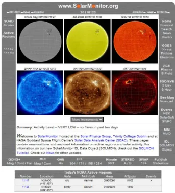
Fig 7. Solar Monitoring Configulation.
Source: www.solarmonitor.org
Space weather by a solar eruption could wreak havoc in this world. A geomagnetic space storm sparked by a solar eruption like the one that flared toward earth last February and June in 2011 is bound to strike again and could wreak havoc across the modern world [8].
Modern society is increasingly brittleness to space weather because of our depending on satellite systems for synchronizing computers, airline navigation, telecommunications networks and other electronic devices [2]. This most harmful disaster has to be observed, forecasted, alarmed and protected by entire scientific
monitoring researches and means.
Fig 8. Space Weather Monitoring by Korea Meteorological Satellite Center http://kmsc.kma.go.kr
2. Monitoring for the Communication Systems
The National Radio Research Center(KSWC; Korean Space Weather Center)uses SWPC’s (space weather prediction center) classification of the prediction and alert report on three different terms(R, S, G) which separated as five different terms (general, concern, attention, warning, severe) on the communication problems by geo-magnetic and radiations(Table 3) [4,9].
Table 3. Space Weather Electric Wave Environment Forecast and Warning Itemed Damageable Fields
Grade Forecast &
Warning Standard Object of Communication Disorder
1 R
(Radio Blackouts)
Day time HG communication blackouts, Satellite communications,
GPS, Low orbit Satellite control, Military operation(HF, GPS, Radar)
2
S (Solar Radiation
Storms)
Polar region HF Radio Blackouts, Polar route airplane safety(HF, radiation being bombed), Standing orbit Satellite control,
Space flight safety
3
G (Geo-magnetic
Storms)
Wide HF Radio Blackouts, Space communications Satellite control, GPS, guidance power line(facility, oil pipes, railroad), Airplane flight(HF, GPS)
Source: SWPC
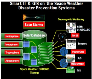
IV. Implementation of the Smart IT and GIS Convergence
1. Implementation of the Mapping Systems
The space weather that spatial information boundary ought to be under-controlled by GIS due to the fact that GIS can provide data compiling, analysis, process, operation and management order to do decision making support systems[11]. This GIS total process exhibits quantity and quality analysis for spatio-temporal implementation of the space weather.
Moreover, the GIS process for the space weather can converge to the smart IT systems not only to get cumulated spatial data but also to generate precise proper forecast to the people. Convergence between space weather field and GIS will contribute to disaster management systems for safety matter. This special approach of proposal could be the initial theory for the new space weather methodology for the spatio-temporal process and for the converged mutual process. In terms of the convergence process of the space weather communication field, the GIS 4-D mapping techniques should be provide for the smart world connections as the universal 3-D mapping generation(Fig 9) [21] as well as the geomagnetic hazqrd map in USA(Fig 11).
Fig 9. Sources: : http://www. The farther the galaxy, the greater its redshift, so redshift measure- ments yield galaxy distances - the vital third dimension in a 3-D map.Source: : http://www.cfa.harvard.edu/
news/ 2011/ pr201116.html
http://www.cfa.harvard.edu/image_archive/2011/
52/hires.jpg
Solar Radiation related damages from sun explores exhibits as followings: Orbit alteration of satellites, malfunctioning of small satellites, differential charging of satellite main systems, Radiation damages of astronauts,
passengers, and attendants, power line damages, Oil pipes, networks, GNSS disturbance, Human body cell damages[19] and etc.
Fig 10. Map of the solar radiation warning areas from geomagnetic forces [10]
2. Implementation of the GIS
The GIS based space weather disaster information systems consist mainly of monitoring information, transformation, satellite image information, each sphere information(heliosphere, geo-magnetosphere, ionosphere, and troposphere), and electricity, electronic and oil pipes information(Fig 11). Moreover space weather seriously effects to the human bodies from solar radiation. In terms Because of the conspicuous harmful to the physical and human organism as geomagnetic hazards by the solar blasters the GIS can provide cumulative space weather data operation and management with strong radiation in order to present safety matters.
Fig 11. Real time mapping systems of the 14 geomagnetic condition receiving sites in the USA. source: the Geologic Hazards Science Center, the USGS Geomagnetism http://geomag.usgs.gov/map/
3. Implementation of the Smart IT and GIS Convergence
The sun endless releases electric wave and charged particles to the geo-magnetosphere. Ionosphere displays very important rolls to the communication networks because it absorbs and reflects emitted waves from ground[6,7].
It is necessary that the implementation of the spatial information systems can be contributed disaster prevention system based management of the ionosphere and emission by sun explosion. This process has to be implemented on the knowledge space weather systems by satellite images and spatial analysis function to reduce problems of satellite communication damage (Fig 12).
Fig 12. GIS based space weather disaster prevention system implementation[13]
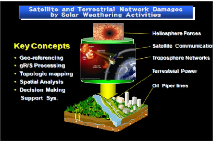
4. Implementation of the decision making support systems for the optimal space weather systems
It is necessary to generate decision making support systems for the optimal space weather systems in order to disaster prevention against sudden impact from the strong sun radiation CME in 900/h. Implementation of the GIS based operation and management systems of the space weather that low frequency and high impact has to be enhanced for protection people(Fig 13)[12].
The system for the decision making support systems for the optimal space weather systems deal with monitoring and servicing to the heliosphere, geo- magnetosphere, ionosphere, and troposphere for the disaster prevention systems[12]. The high solar activity
will be on July 2013 of whereas the low solar activity was on 2008 December. When the sunspots appear to be maximum 60 daily, strong geomagnetic storm may extreme impact on the space environments.
Fig 13. Decision making support systems for satellite and terrestrial network damages by solar weather activities
This research focuses to the damages through space weather impact and effects the meteorological change and climate change by increasing solar activities using ancient solar records that may generate spatio-temporal convergent study on history and engineering fields for future disaster protections through the current solar issues[22].
V. Conclusions
This paper exhibits currently issued the satellite communication system disasters against a prospective havoc from space weather by a solar eruption. Space weather could wreak havoc in this world. A geomagnetic space storm sparked by a solar eruption is bound to strike again and could wreak havoc across the modern world.
Modern society is increasingly brittleness to space weather because of our depending on satellite systems for synchronizing computers, airline navigation, telecommunications networks and other electronic devices.
This most harmful disaster has to be observed and controled by the smart It converged GIS methodologies.
Following result of the GIS based smart space weather information systems has been generated. Spatial information methods have been adapted in this paper for a next generation to operate and manage cumulated space weather data as following.
1. IT based GIS can converge to the space weather data in order to generate smart satellite communication system operation and management.
2. The satellite communication system can deal with upgraded spatial information data of the space weather alterations in order to provide speedy forecast and real time radiation affected satellite networks malfunctions.
3. GIS derived decision making support systems for the optimal satellite communication systems to prevent from damages by space weather forces can be touched the core of the government.
References
[1] Ahn, B.H. Space environmental physics. Sigma press. 253p.
2000.
[2] Ahn, B.H. Sun-Earth Universe Environments Sigma press.
306p. 2009.
[3] Bogdan, T. J. State of the Space Weather Prediction Center 2009, Space Weather Workshop. 2009
[4] Chungnam University. Planning study on the space weather work. Korea Meteorological Administration. NMSC 103p.
2009
[5] Daglis, I.A. (ed.), Space storms and space weather hazards.
Kluwer Academic Press. 2001.
[6] Davila, Joseph. Space weather monitoring sensor. The Space Weather Instrument Workshop for GEOKOMSAT2. NMSC.
pp. 45-48. 2011.
[7] Davila, Joseph. ‘2013year Vision and preparation for the space weather disasters, (KISI). 2011.
[8] Moon, Y.J, Space data of the space weather forecast model (Geostationary Earth Orbit, Korea Multi-purpose SAT:
GEO-KOMPSAT2) Korea Meteorological Administration.
NMSC. pp. 115-132. 2011.
[9] Kyunghee University. Prediction model development of space weather for the space weather forecast. 171p. 2010.
[10] Oh, Jongwoo, H.G. Kim, M.G. Lee, D.R. Chung. Planning study on the space weather work. Korea Meteorological Administration. NMSC 112p. 2011.
[11] Oh, Jongwoo, J.W. Eun. Damage reduction disaster prevention system on the space weather maximun. The Korea Geographical Society. pp. 195-196. 2011.
[12] Oh, Jongwoo, Daeyun shin. An Overview of Prospective Disasters from Space Weather by a Solar Eruption.
Proceeding KAGIS Autumn Conference 2011 & the 13th KOREA & JAPAN International Symposium on GIS. The Korean Association of Geographic Information Studies. pp.
212-214. 2011.
[13] Oh, Jongwoo. Space Weather Disaster Information Systems on Precautions Against a Solar Maximum Flare. The Space
Weather Instrument Workshop for GEO-KOMSAT-2.
NMSC. pp. 71-85. 2011.
[14] Oh, Jongwoo, D.Y. Shin, H.G. Kim, M.G. Lee. A study on the space weather information. The Korean Photographic Geography Society. 2012.
[15] Oh, Jongwoo, GIS based Implementation of the Communication Networks Disaster Management Systems for Solar Maximum. JC-SAT 2012 CONFERNECE Proceedings. 2012.
[16] Park, C.B, Korean history’s puzzul on the sky recorded universe and our history. 252p. 2002.
[17] Park, jaewoo; junghoon Kim; Jinwook Han. Statistical analysis for the solar eruption effect on wireless communication. The Journal of the Korea Society of Space Technology. v. 6(2). pp. 107-111. 2011.
[18] Shin, Daeyun. Current status and future plan for space weather in KMA. The Space Weather Instrument Workshop for GEO-KOMSAT-2. NMSC. pp. 1-8. 2011.
[19] RRA; National Radio Research Center(KSWC; Korean Space Weather Center) www.spaceweather.go.kr
[20] Tinsley, B. A., Influence of solar wind on the global electric circuit, and inferred effects on cloud microscophysics temperature, and dynamics in the troposphere, Space Science Reviews, pp. 1-28. 2000
[21] http://www.cfa.harvard.edu/news/2011/pr201116.html http://www.cfa.harvard.edu/image_archive/2011/52/hires.jpg [22] RRA; National Radio Research Center(KSWC; Korean
Space Weather Center) www.spaceweather.go.kr
[22] Gwak, Yongsil Affact of c.imatic phenonena by space weather. The 4th Space Weather Workshop for application of the space weather forcast on KMC. NMSC. pp. 127-138, 2012.
저자
오 종 우(Jongwoo Oh)
․1975년∼1977년 2월 : 경희대학교 대학 원 지리학과 (BS/MS)
․1992년 12월 : 위스컨신주립대학교 Univ. of Wisconsin, 고기후지형 (Ph.D)
․1998년 5월 : 일리노이주립대학교 Univ. of Illinois, GIS (MA)
․2009년 3월 ∼ 현재 : 남서울대학교 GIS공학과 교수
․2010년 1월 ∼ 현재 : (사)한국동굴학회 회장
<주 관심분야> : 우주기상정보시스템, GIS/IT융합시스템 <관심분야> : 위성통신방재시스템