Selective Encryption Algorithm Based on DCT for GIS Vector Map
P.N. Giao†, Gi-Chang Kwon††, Suk-Hwan Lee†††, Ki-Ryong Kwon††††
ABSTRACT
With the rapid interest in Geographic Information System (GIS) contents, a large volume of valuable GIS dataset has been distributed illegally by pirates, hackers, or unauthorized users. Therefore the problem focus on how to protect the copyright of GIS vector map data for storage and transmission. At this point, GIS security techniques focusing on secure network and data encryption have been studied and developed to solve the copyright protection and illegal copy prevention for GIS digital map. But GIS vector map data is very large and current data encryption techniques often encrypt all components of data. That means we have encrypted large amount of data lead to the long encrypting time and high complexity computation. This paper presents a novel selective encryption scheme for GIS vector map data protection to store, transmit or distribute to authorized users using K-means algorithm. The proposed algorithm only encrypts a small part of data based on properties of polylines and polygons in GIS vector map but it can change whole data of GIS vector map. Experimental results verified the proposed algorithm effectively and error in decryption is approximately zero.
Key words: GIS Vector Map, Selective Encryption, K-means Algorithm, Vector Map Security
※ Corresponding Author : Ki-Ryong Kwon, Address:
(608-737) (599-1) Daeyeon-3dong, Namgu, Busan, Korea, TEL : +82-51-629-6257, FAX : +82-51-629-6230, E-mail
Receipt date : Mar. 14, 2014, Revision date : May. 9, 2014 Approval date : Jun. 5, 2014
†Dept. of IT Convergence and Applications Eng., Pukyong National University
(E-mail : [email protected])
††††Dept. of IT Cooperative System, Gyeongbuk Provincial College
(E-mail : [email protected])
††††Dept. of Information Security, Tongmyong University (E-mail : [email protected])
††††Dept. of IT Convergence and Applications Eng., Pukyong National University
(E-mail : [email protected])
※ This work was supported by a Research Grant of Pukyong National University (2013Year)
1. INTRODUCTION
GIS is a system which designed to capture, store, manipulate, analyze, and manage all kinds of the geographic information and it is the merging system of cartography, statistical analysis, and da- tabase technology [1-2]. It consists of hardware, software, and GIS data. GIS allows us to view, un- derstand, question, interpret, and visualize data in many ways that reveal relationships, patterns, and trends in the form of maps, globes, reports, and charts.
GIS has been used in military and commercial applications for many years. The main component
of GIS is the data. The GIS data has two important properties. Firstly, the effort it takes to put it in a form suitable for use in the GIS applications. This effort increases its cost. Secondly, in most cases the GIS Data contains confidential information which must be kept away from unauthorized users.
Such confidential information includes GIS layers containing troop locations and additional in- formation like movements and mines places in a tactical environment. Hence, it is very important to protect the GIS data. Moreover, the GIS data is too expensive so we have to prevent illegal du- plication and distribution of it. Nowadays, it is too easy for a company to buy some GIS layers, make
(a) (b)
(c) (d)
Fig. 1. An example GIS vector map with city, river and country layers; (a) Railway layer, (b) Lake layer, (c) Building layer, and (d) Railway + Lake + Building layers.
illegal copies from them and distribute or sell them many times without taking any permission from the original GIS data provider. So we have to en- force some kinds of access control on it because the GIS data is sensitive and must not be accessed by unauthorized users.
In section 2, we introduce related works, and in section 3 we present selective encryption scheme for GIS vector map data protection. Finally, we im- plement the proposed scheme, and show ex- perimental results in section 4.
2. RELATED WORKS
The GIS vector map data includes layers. Each layer is a basic unit of geographical objects which are described and managed in a map. These objects describe the topography and geographical features of real objects or a certain place. Each layer con- sists of an amount of vector data which uses pairs of coordinates to describe as point, polyline and polygon [3-4], as shown Fig. 1. Officially, the point is used to present simple or small objects in the
reality on the map while polyline and polygon are used to present complex and large objects. Thus, our algorithm only performs selective encryption for polylines and polygons in GIS vector map.
The general approach of selective encryption is to separate the content into two parts. The first part is the public part, which is un-encrypted and accessible by all users [5-11]. The second part is the protected part; it is encrypted. Only authorized users have access to protected part. Polylines and polygons are selected, and encrypted by random keys combine with randomization and clustering process by K-means algorithm [12], random algo- rithms in DCT domain based on their geographical features [13]. Our algorithm encrypts only some selective DC values of polylines, polygons in DCT domain but it changes the whole map.
3. PROPOSED SELECTIVE ENCRYPTION ALGORITHM
Our method aims to encrypt GIS vector map perceptually and entirely using a few of selected
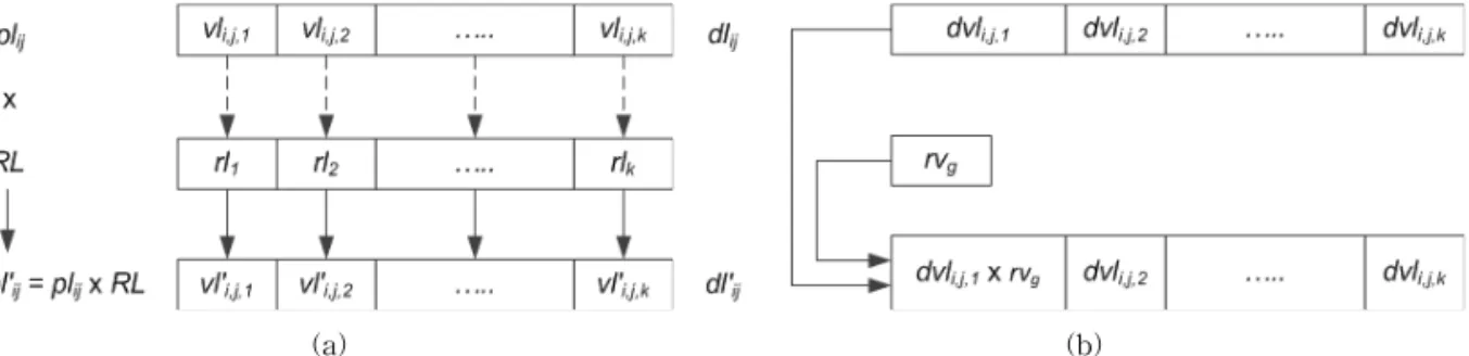
Fig. 2. Selective encryption algorithm for polyline/polygon.
values, it is called as vector map selective encryption.
3.1 Selective Encryption Process
The selective encryption algorithm follows as Fig. 2. Our algorithm consists of processes as data extraction to have polylines and polygons, poly- lines and polygons clustering using K clusters, vertices randomization of polylines and polygons by random coefficients using random key. Next, it applies DCT processing for randomized vertices to get DCT coefficients, and then multiply DC co- efficients of each cluster with a random value which is created by another random key. Finally,
it performs inverse discrete cosine transform (IDCT).
In order to encrypt selectivity, we compute the total number of polylines, total number of pol- ygons in ithlayer. Each polyline/polygon has attributes such as the number of parts and the number of points. These attributes in each poly- line/polygon is different. So, we used them to clas- sify polylines, polygons into clusters using K-means algorithm. We have polylines,
polygons in ithlayer, and we need to cluster them into groups where ∈. Each group in groups is described by a centroid
. Considering number of parts
(a) (b)
Fig. 3. Example of randomization and multiplication for polyline, (a) Randomized example for polyline, (b) Multiplying DC coefficient with random value.
and number of points in jthpolyline/polygon are coordinates in two dimensional space. Andjth polyline/polygon is represented as a point which has coordinates ( ) in that two dimen- sional space. The jthpolyline/polygon is classified in group using the shortest Euclidean distance to follow as equation (1). is the Euclidean distance from jth polyline/polygon to centroid, and calculated by equation (2).
∈∈ i f min⋯ (1)
(2) Then, we find m ax of the max number of vertices in a polyline, and m ax of the max num- ber of vertices in a polygon inithlayer. With values
m ax, m ax and , we generated random
m ax coefficients where ∈ m ax for polylines, random m ax coefficients where
∈ m ax for polygons by random key R1 using equations (3) and (4):
∈ m ax (3)
∈ m ax (4) From m ax and m ax coefficients, we ran- domize them with vertices in polylines, polygons follow as equations (5) and (6). These random co- efficients will be applied to all polylines/polygons in a layer depend on the number of vertices in a polyline/polygon because number of vertices in a polyline≤ m ax, number of vertices in a pol- ygon≤ m ax. And each layer will be applied
different random coefficients. After randomization step polylines/polygons are encrypted by random key , and we receive new polylines with
′′ ∈ ′ ∈ ∈ , and new polygons with
′′ ∈ ′ ∈ ∈ . Fig. 3(a) shows a randomized example for polyline.
′ ×
′ × ∈∈ (5)
′ ×
′ × ∈∈ (6) We continue to apply DCT for these new poly- lines/polygons to get a set of transformed polylines
by equation (7) and a set of transformed poly- gons by equation (8).
′ ∈
∈∈ (7)
′ ∈
∈∈ (8) After DCT processing, we continue to encrypt polylines/polygons one more time by multiplying DC coefficients of transformed polylines/polygons with one corresponding random value to their group, from K random values follow as equations (9), (10) and Fig. 3(b). random values are
∈, and generated by random keyR2
Fig. 4. Selective decryption algorithm for polyline/polygon.
using the used random algorithm above.
′ (9)
×⋯ ∈∈
′ (10)
× ⋯ ∈∈
∈ (11) Finally, we perform IDCT to get encrypted poly- lines , polygons by equations (12) and (13).
′ (12)
∈ ∈∈
′ (13)
∈ ∈∈ for ∈.
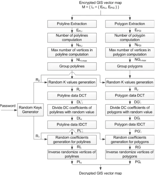
3.2 Selective decryption process
The decryption algorithm for these polylines and polygons shown by Fig. 4 is the inverse process of selective encryption given at Fig. 2. Similar with the selective encryption process, we must also ex- tract the protected data which consists of en- crypted polylines and encrypted polygons, compute number of polylines and polygons, and find max- imum number of vertices in polylines and polygons.
(a) (b)
(c) (d)
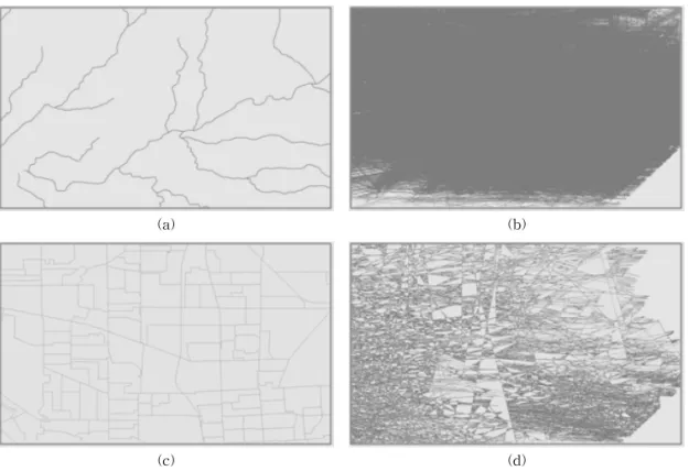
Fig. 5. Experimental result with scaling layers 1:5000; (a) original polyline layer, (b) encrypted polyline layer, (c) original polygon layer, and (d) encrypted polygon layer.
Table 1. The result of loss accuracy
Map Original (Kb) Encryption (Kb)
Polyline layer 68 68
Polygon layer 449 449
Map 1:10000 2724 2724
Map 1:100000 45,938 45,938
The next step is to divide them into several groups by using K-means algorithm, similar with the en- cryption process, because the encryption changes the value of vertices only. Then, random co- efficients and random values are generated again by random generator using random keys. Firstly, encrypted polylines and encrypted polygons are transformed using DCT and the DC coefficients are divided by random values. Secondly, they are in- versed using IDCT to get randomized polylines and polygons again. Finally, we perform inverse ran- domization by dividing values of polylines/poly- gons in IDCT domain for random coefficients to have decrypted polylines and polygons.
4. EXPERIMENTAL RESULTS
We used 1:5000, 1:10000, and 1:100000 scaling maps in our experiments. Firstly, we experimented with each polyline layer and polygon layer with the scale of 1:5000. Then, we tested the full layers of
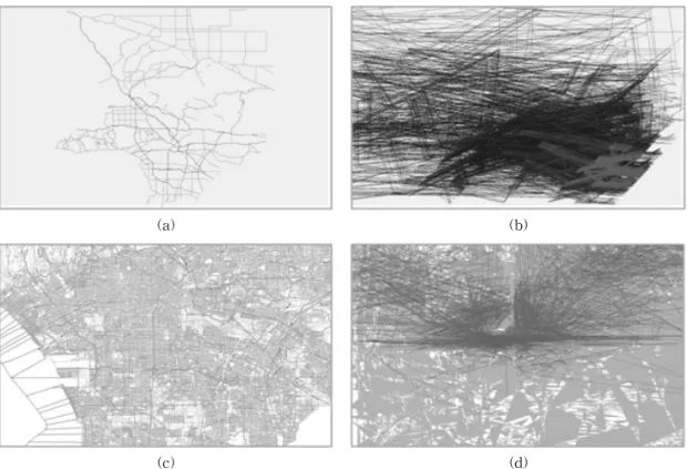
1:10000 and 1:100000 scale. Experimental results with polyline layer, polygon layer and full maps show that all maps are changed as given by Fig.
5 and Fig. 6. Unauthorized user cannot see any- thing on map because we changed polylines and polygons through four processes: randomization, DCT, multiplication, and IDCT using random keys
.
Our selective encryption scheme only changes values of vertices in polylines and polygons of the map. It did not alter the size of encrypted file. The result of loss accuracy is shown in Table 1. In ad- dition, DCT and IDCT are not processes absolutely.
(a) (b)
(c) (d)
Fig. 6. Experimental result with full scaling map 1:10000, 1:100000; (a) original map 1:10000, (b) encrypted map 1:10000, (c) original map 1:100000, and (d) encrypted map 1:100000.
Table 2. The error between original coordinates and decrypted coordinates
Original Decryption Error
30.389433636 30.389433636… 3.5171865420125E-12 31.441894545 31.441894544… 2.57927013080916E-12 30.395796636 30.395796635… 1.24096288800501E-11 31.440130545 31.440130545… 8.66862137627322E-13
… … …
31.842996636 31.8429966359… 1.56319401867222E-13 31.523812545 31.523812545… 4.9737991503207E-14 That means, if we have an input sequence , and we perform DCT to get , and next we perform IDCT to get input sequence again
′, it shows that
′ is not absolutely equal to because the cosine value is not integer. However, in GIS vector map data, vertices are stored in double type such that the errors between original vertices and decrypted vertices values are approximately zero as given by Table 2.
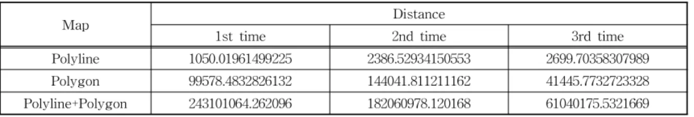
Finally, the distance between maps is com- puted by equation (14):
max′ ″ ∈ (14) We used polyline map, polygon map to experi- ment other three times. Each time, we encrypted maps with different passwords which are used to create random keys as figure 3. Then we calculate
distances of each experimental time. In Table 3, experimental results show that distance of two maps which are encrypted by different pass- words from an original map is depend on passwords.
5. CONCLUSION
Our paper focuses on the issues how to encrypt GIS vector map selectivity with low complexity.
We classified objects and encrypted them by ran- dom algorithms in DCT domain. Only some values are selected to encrypt by random processes but
Table 3. Experimental distance measure
Map Distance
1st time 2nd time 3rd time
Polyline 1050.01961499225 2386.52934150553 2699.70358307989
Polygon 99578.4832826132 144041.811211162 41445.7732723328
Polyline+Polygon 243101064.262096 182060978.120168 61040175.5321669
it made changing whole map. Experimental results showed that the proposed algorithm has very ef- fective with a large volume of GIS dataset.
Decrypting results also show the error in de- cryption process approximates zero. Our algorithm can be applied to various file formats or standard vector map because only polyline and polygon ob- jects are encrypted and can be used for map data- base security of GIS map service on/off-lines.
Furthermore, our algorithm can be applied to vari- ous vector contents such as CAD and 3D content fields. Next time, we will continue to improve our algorithm by reducing number of selective values to reduce complexity while not change effectively.
REFERENCE
[ 1 ] K.E. Foote and M. Lynch,Geographic Infor- mation Systems as an Integrating Technology:
Context, Concepts, and Definitions, June 2011.
[ 2 ] M.F. Goodchild, “Twenty Years of Progress:
GIS Science in 2010,”Journal of Spatial Infor- mation Science, No. 1, pp. 3-20, July 2010.
[ 3 ] Geographic Information System(2004), http://en.wikipedia.org/wiki/Geographic_in- formation_ system. (accessed Nov. 2013) [ 4 ] GIS Vector Map(2006), http://en.wikipedia.
org/wiki/Vector_map. (accessed Nov. 2013) [ 5 ] A. Massoudi, F. Lefebvre, C. De Vleeschouwer,
B. Macq, and J.-J.Quisquater, “Overview on Selective Encryption of Image and Video:
Challenges and Perspectives,”Hindawi P ub- lishing Corporation EURASIP J ournal on Information Security, Vol. 2008, No. 5, Article ID:179290, pp. 18, 2008.
[ 6 ] M. Abomhara,Enhancing Selective Encryption for H.264/AVC Using Advanced Encryption Standard, University of Malaya, Kuala Lum- pur, 2011.
[ 7 ] M.Y. Hasan, F.A. Ahmed, and K. Abdelhamid,
“Image Adaptive Selective Encryption of Vector Quantization Index Compression,”Pro- ceeding of IEEE International Conference on Image P rocessing, pp. 1277-1280, 2009.
[ 8 ] W. Puech and J.M. Rodrigues, “Crypto- Compression of Medical Images By Selective Encryption of DCT,”Proceeding of European Signal Processing Conference, Vol. 1, pp.
225-228, 2005.
[ 9 ] S. Sharma and P. Pateriya, “A Study on Different Approaches of Selective Encryption Technique,”International Journal of Computer Science & Communication Networks, Vol. 2, Issue 6, pp. 658-662, 2012.
[10] B.J. Jang. K.S. Moon. S.H. Lee. and K.R.
Kwon. “Effective Compression Technique for Secure Transmission and Storage of GIS Digital Map,” Journal of Korea Multimedia Society Vol.14. No2. pp.210-218, Feb. 2011.
[11] M.G Nazneen, S. Banu, Z. Tabassum, K.
Fatima, and A. Shariff, “Selective Bitplane Encryption for Secure Transmission Of Image Data In Mobile Environment,” International Journal of Scientific & Technology Research, Vol. 2, Issue 6, pp. 92-96, June 2013.
[12] Mac Queen,Some Methods for Classification and Analysis of Multivariate Observations, University of California Press, Berkeley, Calif., Vol. 1, pp. 281-297, 1967.
[13] G. Strang, “The Discrete Cosine Transform,”
Society for Industrial and Applied Mathe- matics, Vol. 41, No. 1, pp. 135-147, 1999.
Giao Pham Ngoc Giao Pham Ngoc received a B.S.
degree in School of Electronic &
Telecommunication from Hanoi University of Science & Tech- nology (HUST) in 2011, and Master degree from Pukyong National University (PKNU) in 2014. Currently, he is an researcher in Multimedia Communication & Signal Processing Lab in PKNU.
His research interests include video processing & ap- plication, GIS applications, data security, and smart system.
Gi-Chang Kwon
Gi-Chang Kwon received a B.S., a M.S., and Ph.D. degrees from Andong National Univer- sity in 1985, Daegu Univsrsity in 1993, and Yeongnam Univer- sity in 2000. Currently, he is a professor in Department of IT Cooperative System at Geongbuk Provincial College.
His research interests include multimedia contents and image processing, digital contents and smart system.
Suk-Hwan Lee
He received a B.S., a M.S., and a Ph. D. degrees in Electrical Engineering from Kyungpook National University, Korea in 1999, 2001, and 2004 respectively.
He is currently an associate professor in Department of In- formation Security at Tongmyong University. His re- search interests include multimedia security, digital image processing, and computer graphics.
Ki-Ryong Kwon
He received the B.S., M.S., and Ph.D. degrees in electronics en- gineering from Kyungpook Na- tional University in 1986, 1990, and 1994 respectively. He work- ed at Hyundai Motor Company from 1986-1988 and at Pusan University of Foreign Language from 1996-2006. He is currently a professor in Department of IT Convert- gence and Application Engineering at the Pukyong National University. He has researched University of Minnesota in USA on 2000~2002 with Post-Doc. and Colorado State University on 2011~2012 with visiting professor. He is currently the General Affair Vice President of Korea Multimedia Society. His research interests are in the area of digital image processing, multimedia security and watermarking, bioinformatics, weather radar information processing.