Revised Geology of the Deokjeok and Soya Islands in the Central-western Korean Peninsula
13
0
0
전체 글
(2) 632. Jeong-Yeong Park and Seung-Ik Park. Fig. 1. (a) Simplified tectonic map of the Korean Peninsula and adjacent areas (modified from Cluzel, 1992; Zheng et al., 2013). The gray box denotes the area shown in Fig. 1b. (b) Geologic map of the central-western Korean Peninsula (adapted from Kim et al., 2019). The gray rectangular box indicates the study area, which includes the Deokjeok and Soya islands.. complex fault and shear zone system controlling the distribution of the main lithologic units. From this map, we obtained new insights on the geology of the Deokjeok and Soya islands, and especially on the Mesozoic tectonic transitions and orogenic cycles in the central-western Korean Peninsula. On this base, we propose future directions of study to address issues regarding the deformational responses of crust to the orogenic evolution of this area.. 2. Lithologic Units The lithologic units observed on the Deokjeok and Soya islands are shown in our new geologic map (Fig. 2). A detailed description of the lithologic units is reported below.. 2.1. Paleoproterozoic metaplutonic rocks Paleoproterozoic metaplutonic rocks are distributed along the northwestern coast of the Deokjeok Island, and occur either as a small basement terrain or a fault-bounded sliver. The corresponding lithologic unit is mainly composed of metagranitic and metadioritic rocks. In the metagranitic rocks, subhedral to anhedral porphyroclasts of pinkish K-feldspar (ranging from 1 mm to 10 cm in size) are embedded in a groundmass composed mainly of quartz, feldspar, and amphibole (Fig. 3a, b). Meanwhile, the metadioritic rocks are medium- to coarsegrained, have a bluish gray color (Fig. 3c), and are mainly composed of amphibole and plagioclase, associated with minor quartz, chlorite, apatite, zircon, and opaque minerals. Additionally, these.
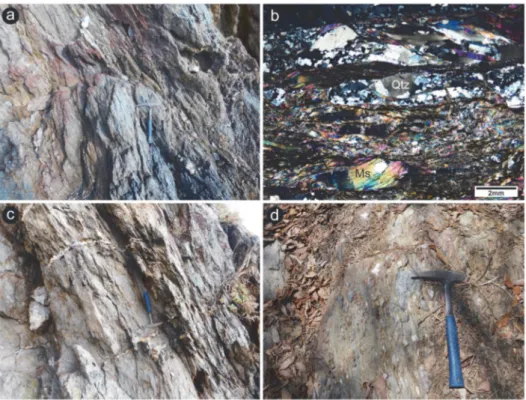
(3) Revised Geology of the Deokjeok and Soya Islands in the Central-western Korean Peninsula. 633. Fig. 2. New geologic map and cross-sections of the Deokjeok and Soya islands. Abbreviations: N.F.―Neungdong Fault, B.T.―Buk-ri Thrust, K.F.―Keunmal Fault.. rocks contain feldspar porphyroclasts with a long axis of up to 7 cm (Fig. 3c, d). Notably, the deformed metadioritic rock occurring along the boundary with the Deokjeok Formation presents foliation, which is associated with strongly elongated feldspar porphyroclasts (Fig. 3e, f). The protolith age of this unit is Paleoproterozoic and was obtained through zircon U–Pb isotopic analyses: most of the zircons yielded 207Pb/206Pb apparent ages ranging from ca. 1870 to 1840 Ma (Park et al., unpublished data, 2018). 2.2. Neoproterozoic mica schist Neoproterozoic mica schist is well exposed in the northern part of Deokjeok Island. They are brown, medium- to coarse-grained, and composed mainly of muscovite, biotite, and quartz with minor opaque minerals (Fig. 4a, b). This lithology displays a strong foliation, defined by the alignment of elongated quartz aggregates and mica, that generally. strikes NNE–NW and dips consistently northeastward at 50°–80°. The mica schist is frequently cut by quartz veins with widths of several to tens of centimeters, which are subperpendicular or subparallel to the foliation (Fig. 4c). This lithologic unit locally contains meta-conglomerate layers; the pebbles contained within them (with long axes up to 10 cm long) are aligned along the foliation (Fig. 4d). Based on the youngest U–Pb age (ca. 980 Ma) obtained from the analysis of detrital zircon cores extracted from the mica schist, Cho and Lee (2016) have stated that its protolith should have deposited during the Neoproterozoic. Moreover, based on the U–Pb isotopic data obtained from the analysis of the detrital zircons’ overgrowth rims, the same authors proposed a Late Permian to Early Triassic (ca. 259–248 Ma) metamorphism. 2.3. Paleozoic mica schist Paleozoic mica schist is locally distributed in the.
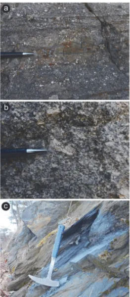
(4) 634. Jeong-Yeong Park and Seung-Ik Park. Fig. 3. Photographs of the Paleoproterozoic metaplutonic rock. (a) Outcrop photograph of the metagranitic rock. (b) Photomicrograph (cross-polarized light) of the metagranitic rock. (c) Outcrop photograph of the metadioritic rock. (d) Feldspar porphyroclasts in the metadioritic rock. (e) Outcrop photograph of the extremely deformed metadioritic rock. (f) Photomicrograph (cross-polarized light) of the deformed metadioritic rock. Abbreviations: Am―Amphibole, Qtz―Quartz, Kfs―K-feldspar, Pl―Plagioclase.. northernmost part of Deokjeok Island and is overlain by the Early Jurassic Deokjeok Formation. This lithology is bluish gray, medium-grained, and consists mainly of quartz, muscovite, and biotite. Moreover, it displays a strong foliation (Fig. 5), which is defined by the alignment of muscovite, biotite, and elongated quartz aggregates, generally striking NNW, and dipping northeastward. Its protolith age, which was defined based on the zircon U–Pb isotopic ages of the youngest detritus. and of the oldest intrusive rock, is ca. 435–379 Ma (Cho and Lee, 2016). 2.4. Late Triassic biotite granite Late Triassic biotite granite is most widely distributed on Deokjeok Island. It is typically gray to light gray, equigranular, and fine- to mediumgrained, but locally shows a porphyritic texture (Fig. 6a). This lithology is primarily composed of quartz, plagioclase, alkali feldspar, and biotite..
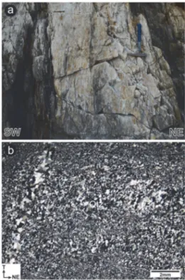
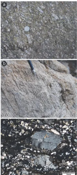
(5) Revised Geology of the Deokjeok and Soya Islands in the Central-western Korean Peninsula. 635. Fig. 4. Photographs of the Neoproterozoic mica schist. (a) Outcrop photograph of the mica schist. (b) Photomicrograph (cross-polarized light) of the mica schist. (c) Outcrop photograph showing quartz veins subperpendicular to the foliation of the mica schist. (d) Outcrop photograph of the meta-conglomerate layer with elongated pebbles. Abbreviations: Qtz— Quartz, Ms—Muscovite.. foliation generally strikes NW, dips northeastward, and the stretching lineation plunges northeastward. Based on zircon U–Pb isotopic analysis, the emplacement age of the biotite granite was defined to be ca. 223 Ma (Cho and Lee, 2016).. Fig. 5. Outcrop photograph of the Paleozoic mica schist.. Sericite commonly occurs in altered feldspars; moreover, zircon, epidote, and opaque minerals occur as accessory minerals. The biotite granite along the northeastern coast of Deokjeok Island was strongly deformed in a ductile manner, and hence converted to mylonite or protomylonite with penetrative fabrics (Fig. 6b, c). The mylonitic. 2.5. Late Triassic quartzolite Late Triassic quartzolite is distributed in the northeastern part of Soya Island, and occurs in the form of thick fine-grained quartzose layers (Fig. 7a) trending NW (parallel to the mylonitic foliation in the nearby deformed granites). This lithology is mainly composed of quartz with minor biotite and was mylonitized by ductile shearing. The mylonitic foliation generally strikes NW, dips northeastward, and is marked by a stretching lineation plunging northeastward. Slightly elongated quartz grains define a steady state (oblique) foliation in the deformed quartzolite (Fig. 7b); additionally, the mylonitic fabrics are locally cut by thin massive quartz veins (Fig. 7b). This lithologic unit corresponds to the Paleozoic.
(6) 636. Jeong-Yeong Park and Seung-Ik Park. Fig. 7. Photographs of the Late Triassic quartzolite. (a) Outcrop photograph of the quartzolite. (b) Microphotograph (cross-polarized light) of the quartzolite. Abbreviation: Qtz—Quartz.. this lithologic unit, we redefined it as a Late Triassic quartz-rich intrusive igneous rock body (‘a quartzolite’).. Fig. 6. Photographs of the Late Triassic biotite granite. (a) Outcrop photograph of the biotite granite. (b) Outcrop photograph of the mylonitized biotite granite. (c) Microphotograph (cross-polarized light) of the mylonitized biotite granite. Abbreviations: Qtz—Quartz, Kfs—K-feldspar, Bt—Biotite.. quartz schist previously described by Cho and Lee (2016). However, most of the apparent 206Pb/238U dating analyses indicate a Late Triassic age (ca. 220 Ma; Park et al., unpublished data, 2019). Notably, the quartzolite is not spatially associated with metasedimentary sequences, but rather with the Late Triassic intrusive rocks described previously and below (Fig. 2). Based on the mineral composition, lithologic assemblage, and U–Pb isotopic data of. 2.6. Late Triassic layered felsic intrusive rock Late Triassic layered felsic intrusive rock is exposed in the easternmost part of Deokjeok Island and in the northeastern part of Soya Island. This lithology is composed of alternations of thin leucocratic layers (thickness of up to 10 cm) and thick gray layers (thickness between several centimeters to 1 m) (Fig. 8a). Its layers strike NW and generally dip northeastward. The leucocratic layer is fine-grained and mainly composed of quartz, alkali feldspar, plagioclase, and biotite (Fig. 8b), moreover, some altered feldspars transformed into sericite. The gray layers are extremely fine-grained and consist mainly of quartz, alkali feldspar, and plagioclase with minor microcline, epidote, chlorite, and sericite (Fig. 8c). Down-dip verging asymmetrical folds ubiquitously occur in the layered felsic intrusive rock (Fig. 8a). Finally, most of the igneous.
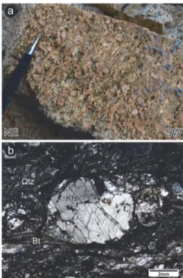
(7) Revised Geology of the Deokjeok and Soya Islands in the Central-western Korean Peninsula. 637. Fig. 8. Photographs of the Late Triassic layered felsic intrusive rock. (a) Outcrop photograph of the layered felsic intrusive rock showing a down-dip verging asymmetric fold. (b) Microphotograph (cross-polarized light) of the leucocratic layer. (c) Microphotograph (cross-polarized light) of the gray layer. Abbreviations: Qtz—Quartz, Kfs—K-feldspar.. Fig. 9. Photographs of the Late Triassic porphyritic granite. (a) Outcrop photograph of the porphyritic granite. (b) Outcrop photograph of the mylonitized porphyritic granite. (c) Microphotograph (cross-polarized light) of the mylonitized porphyritic granite. Abbreviations: Qtz—Quartz, Kfs—Kfeldspar, Bt—Biotite.. zircons from the layered felsic intrusive rock yielded apparent 206Pb/238U ages ranging between ca. 220– 215 Ma (Park et al., unpublished data, 2018).. shows a gradual transition in the abundance of alkali feldspar phenocryst: this is a unique criterion to distinguish lithologic units. The major axis of the alkali feldspar phenocrysts is about 4–5 cm long (Fig. 9a) and their preferred orientation locally defines a magmatic foliation that generally strikes NW and dips northeastward. Along the eastern coast of Deokjeok Island and the northeastern coast of Soya Island, the porphyritic granite was. 2.7. Late Triassic porphyritic granite Late Triassic porphyritic granite is distributed along the eastern coast of Deokjeok Island and on Soya Island. This lithology has a mineral composition similar to that of the biotite granite and.
(8) 638. Jeong-Yeong Park and Seung-Ik Park. Fig. 10. Outcrop photograph showing field evidence of diorite-granite magma mingling. (a) Contact between the Late Triassic diorite and the porphyritic granite. (b) Diorite inclusions in the Late Triassic porphyritic granite.. Fig. 11. Photographs of the Late Triassic syenogranite. (a) Outcrop photograph of the mylonitized syenogranite. (b) Microphotograph (cross-polarized light) of the mylonitized syenogranite. Abbreviations: Qtz—Quartz, Kfs—K-feldspar, Bt—Biotite.. deformed in a ductile manner and converted into mylonite or protomylonite (Fig. 9b, c). The mylonitic foliation strikes NW and dips northeastward; moreover, it is marked by a stretching lineation generally plunging northeastward. The emplacement age of the porphyritic granite, defined by zircon U–Pb isotopic analyses, is ca. 218 Ma (Cho and Lee, 2016; Park et al., 2020).. easternmost part of Soya Island and is characterized by an overall pinkish color due to its significant content of alkali feldspar (Fig. 11a). This lithology was strongly deformed in a ductile manner and mylonitized. The alkali feldspar porphyroclasts contained within it have a maximum axis of about 3 cm and are embedded in a gray matrix. This matrix mainly consists of alkali feldspar, plagioclase, quartz, and biotite with minor zircon, epidote, and opaque minerals (Fig. 11b). The mylonitic foliation generally strikes NW and dips northeastward, while a stretching lineation plunges northeastward. Most of the igneous zircons from the syenogranite yielded apparent 206Pb/238U ages of ca. 220–210 Ma (Park et al., unpublished data, 2018).. 2.8. Late Triassic diorite Late Triassic diorite is locally distributed in small stocks that invaded the porphyritic granite on Soya Island (Fig. 10a). This lithology is dark gray, fine- to medium-grained, and mainly consists of amphibole, feldspar, and biotite; moreover, diorite occurs in the form of inclusions in the porphyritic granite along the northeastern coast of Soya Island, suggesting a magma mingling process (Fig. 10b). 2.9. Late Triassic syenogranite Late Triassic syenogranite is distributed in the. 2.10. Late Triassic Jin-ri Formation The Jin-ri Formation is represented by Late Triassic volcano-sedimentary strata distributed along the eastern coast of Deokjeok Island. This.
(9) Revised Geology of the Deokjeok and Soya Islands in the Central-western Korean Peninsula. 639. formation is composed of alternating layers of conglomerate, sandstone, and slate (Fig. 12a–c), all slightly metamorphosed and deformed. Pebblebearing phyllite and volcanic rocks (i.e., felsic tuff and quartz porphyry) are conformably interlayered in the sedimentary sequences (Park et al., 2020). The sandstone is light to dark gray, medium- to very coarse-grained, and locally contains subangular quartz and feldspar fragments (Fig. 12b). In general, the bedding of the Jin-ri Formation strikes NW and dips northeastward. Notably, the slaty and phyllitic cleavages are subparallel to the bedding.. The volcanic layers of the Jin-ri Formation yielded Late Triassic zircon U–Pb ages (ca. 221– 217 Ma), which likely indicate the timing of syndepositional volcanism (Park et al., 2020). Park et al. (2020) grouped the Jin-ri Formation into the Deokjeok Formation. However, based on the differences in lithology, deposition age, metamorphic grade, and distribution, we define it here as a new lithostratigraphic unit.. Fig. 12. Outcrop photographs of the Late Triassic Jin-ri Formation. (a) Sandstones. (b) Pebbly sandstones with feldspar fragments. (c) Gray slate.. Fig. 13. Outcrop photographs of the Early Jurassic Deokjeok Formation. (a) Conglomerates. (b) Medium to coarse sandstones. (c) Dark gray mudstones.. 2.11. Early Jurassic Deokjeok Formation The Deokjeok Formation, which was first named.
(10) 640. Jeong-Yeong Park and Seung-Ik Park. by Cho and Lee (2016), is distributed in the northern part of Deokjeok Island and composed of alternating layers of conglomerate, sandstone, and mudstone (Fig. 13a–c). The conglomerate is composed of subrounded to subangular quartzite, granite, gneiss, and volcanic clasts with sizes between 2– 200 mm and dispersed in a light gray to brownish gray sandstone matrix (Fig. 13a). The sandstone is light to middle or brownish gray and fine- to coarse-grained (Fig. 13b), while the mudstone is dark gray (Fig. 13c). Based on the youngest zircon U–Pb age (ca. 188 Ma), obtained from a volcanic pebble in the conglomerate, Cho and Lee (2016) suggested that the Deokjeok Formation was deposited during the Early Jurassic or later.. 3. Geologic Structures The lithologic units encountered on the Deokjeok and Soya islands and described above are strongly controlled by NW–trending macro-scale ductile shear zones and a contractional fault system (Fig. 2). Along the eastern coasts of the Deokjeok and Soya islands, two NW-trending and NE-dipping ductile shear zones (i.e., Deokjeok Shear Zone (DSZ) and Soya Shear Zone (SSZ)) are developed in the Late Triassic plutonic rocks (Fig. 2; Park et al., 2020). Park et al. (2020) reported that the DSZ and the SSZ have different structural positions and kinematics. The DSZ structurally underlies the Late Triassic Jin-ri Formation, and shows a top-downto-the-northeast shearing. On the other hand, the SSZ overlies the Late Triassic Jin-ri Formation, and contains evidences of a top-up-to-the-southwest shearing following a top-down-to-the-northeast sense of movement (Figs. 7 and 8 from Park et al., 2020). Notably, the DSZ spatially separates the Late Triassic to Early Jurassic sedimentary rocks from the Jin-ri Formation and the Deokjeok Formation. The NW- to N-trending contractional fault system identified on the Deokjeok and Soya islands includes the Neungdong Fault, the Buk-ri Thrust, and the Keunmal Fault (Fig. 2). The Neungdong Fault is a contractional fault that carried an isolated, lensshaped and fault-bounded Paleoproterozoic basement sliver upon the Early Jurassic Deokjeok Formation. The Buk-ri Thrust, instead, placed the Neoproterozoic mica schist over the Early Jurassic Deokjeok. Formation. Finally, the Keunmal Fault placed the Late Triassic granite over the Late Triassic Jin-ri Formation and defines the southwestern boundary of the SSZ.. 4. Discussion and Conclusions The central-western Korean Peninsula contains records of a complex crustal deformation associated with Mesozoic plate marginal processes (Oh et al., 2005; Kim et al., 2006; Kwon et al., 2009; Park et al., 2014, 2018, 2019, 2020; de Jong et al., 2015; Cho et al., 2017). The overthickened crust of the peninsula caused by an Early Mesozoic continental collision has been affected by high-K calc-alkaline and shoshonitic magmatism, metamorphism, and crustal stretching related to Late Triassic postcollisional processes (Kwon et al., 2009; Williams et al., 2009; Kim et al., 2011; de Jong et al., 2015; Park et al., 2018, 2020). As the tectonic regime changed to subduction, the central-western Korean Peninsula started to be influenced by arc magmatism and local intra-arc subsidence during the Early to Middle Jurassic (Park et al., 2009; Kee et al., 2010; Kim et al., 2015; Park et al., 2018); moreover, a shortening and positive structural inversion of the basement probably occurred due to the low-angle or flat subduction of the Paleo-Pacific Plate during the Late Jurassic to Early Cretaceous (Park et al., 2018, 2019). Within the Mesozoic tectonic framework of the central-western Korean Peninsula remarked above, the Deokjeok and Soya islands experienced multiple Mesozoic crustal deformation events related to a tectonic transition (from post-collision to subduction). The DSZ is an extensional high-strain zone controlling the distribution of the Late Triassic Jin-ri Formation. Since the Jin-ri Formation is juxtaposed with the nearly contemporaneous mylonitized granite, the DSZ probably behaved as an extensional detachment during the post-collisional orogenic collapse, as suggested by Park et al. (2020). The occurrence of the Deokjeok Formation in the footwall of the DSZ indicates that the mechanical subsidence continued until the Jurassic. The contractional fault system and the SSZ in the Deokjeok and Soya islands suggest that a horizontal shortening followed the crustal extension and that the area was structurally inverted. The.
(11) Revised Geology of the Deokjeok and Soya Islands in the Central-western Korean Peninsula. isolated, fault-bounded basement sliver carried by the Neungdong Fault was geometrically and kinematically similar to a basement block formed by a shortcut faulting of a basement ramp and diagnostically recognized in diverse types of inverted extensional basin (Hayward and Graham, 1989; Coward, 1994). The Jurassic to Early Cretaceous subduction tectonics in the Korean Peninsula (Sagong et al., 2005; Kim et al., 2016) were likely the cause of the basement-involved crustal shortening and structural inversion noted on the Deokjeok and Soya islands and interpreted in an adjacent area by Park et al. (2018, 2019), although additional geochronological data are required to confirm this idea. Further studies on the geology of the Deokjeok and Soya islands and adjacent areas will help to refine the correspondent structural and tectonic evolutionary models. 1) Detailed information of the P-T-t path of the Neoarchean tonalitic migmatite on Daeijak Island (on the footwall side of the DSZ) is required to support the extensional detachment model. Whether Late Triassic isothermal decompression and anatexis are recorded in the migmatite is important to test the detachment-controlled orogenic collapse model (Teyssier and Whitney, 2002; Whitney et al., 2004). The Late Triassic U– Th–Pb ages obtained from the allanite in the migmatite (Kim et al., 2009) raise the possibility of Late Triassic anatexis. 2) Deformation (i.e., mylonitization and faulting) ages are required to clarify the relationship between the Late Jurassic to Early Cretaceous subduction tectonics and the structural inversion in the Deokjeok and Soya islands. The 40Ar/39Ar ages obtained from the mica in the mylonite and K–Ar ages obtained from fine-grained white mica in the cataclastic fault rock (Oriolo et al., 2018 and references therein) would be useful to constrain the timing of crustal shortening and structural inversion following crustal extension. 3) Strain and vorticity data are needed to fully understand the kinematic evolution of extensional and contractional structures in the Deokjeok and Soya islands. Detailed information from the kinematic parameters on the material movement would be provide clues to reconstruct the spatio-temporal evolution of the tectonic regime (e.g., Xypolias et al., 2010; Ring et al.,. 641. 2015; Spanos et al., 2015; Mookerjee et al., 2016; Behyari and Shahbazi, 2019). A comprehensive study on the Deokjeok and Soya islands and the adjacent areas will lead to an improved understanding of the Mesozoic structural and tectonic evolution of the central-western Korean Peninsula as part of an orogenic belt, and of the diachronous aspect of the tectonic cycles in the Mesozoic East Asian continental margin (Kim, 2019; Jang and Cheong, 2019).. Acknowledgments This work was supported by the Basic Research Program of the National Research Foundation of Korea (Grant no. 2018R1C1B6003851), which was funded by the Ministry of Science and ICT and granted to S.-I. Park. We thank Dr. Seung-Bae Lee for his assistance in defining the geology of the Deokjeok and Soya islands during the early stages of this study. Finally, we appreciate two anonymous reviewers for their constructive comments, which improved the manuscript.. References Behyari, M. and Shahbazi, M. (2019) Strain and vorticity analysis in the Zagros suture zone (W Iran): Implications for Neo-Tethys post-collision events. J. Struct. Geol., v.126, p.198-209. Cho, D.-L. and Lee, S.-B. (2016) Geological report of the Gureopdo·Deokjeokdo·Baegado·Seongapdo sheets (1:50,000). Korea Institute of Geoscience and Mineral Resources, 54p (in Korean with English abstract). Cho, M., Lee, Y., Kim, T., Cheong, W., Kim, Y. and Lee, S.R. (2017) Tectonic evolution of Precambrian basement massifs and an adjoining fold-and-thrust belt (Gyeonggi Marginal Belt), Korea: An overview. Geosci. J., v.21, p.845-865. Cluzel, D. (1992) Formation and tectonic evolution of early Mesozoic intramontane basins in the Ogcheon belt (South Korea): a reappraisal of the Jurassic “Daebo orogeny”. J. Southeast Asian Earth Sci., v.7, p.223-235. Coward, M.P. (1994) Inversion tectonics. In Hancock, P.L. (ed.) Continental Deformation. Pergamon Press, p.280304. de Jong, K., Han, S. and Ruffet, G. (2015) Fast cooling following a Late Triassic metamorphic and magmatic pulse: implications for the tectonic evolution of the Korean collision belt. Tectonophysics, v.662, p.271-290. Hayward, A.B. and Graham, R.G. (1989) Some geometrical characteristics of inversion. In Cooper, M.A. and Williams, G.D.(eds.), Inversion Tectonics. Geological Society of London, Special Publication, v.44, p.17-39..
(12) 642. Jeong-Yeong Park and Seung-Ik Park. Jang. Y. and Cheong, H.J. (2019) Sturctural Geometry of the Pyeongchang-Jeongseon Area of the Northwestern Taebaeksan Zone, Okcheon Belt. Econ. Env. Geol., v.52, p.541-554 (in Korean with English abstract). Kee, W.-S., Kim, S.W., Jeong, Y.-J. and Kwon, S. (2010) Characteristics of Jurassic continental arc magmatism in South Korea: tectonic implications. J. Geol., v.118, p.305-323. Kim, H.S. (2019) Reassessment of the Pyeongan Supergroup: Metamorphism and Deformation of the Songrim Orogeny. Econ. Env. Geol., v.52, p.367-379 (in Korean with English abstract). Kim, S.W., Oh, C.W., Williams, I.S., Rubatto, D., Ryu, I.C., Rajesh, V.J., Kim, C.-B., Guo, J. and Zhai, M. (2006) Phanerozoic high-pressure eclogite and intermediate pressure granulite facies metamorphism in the Gyeonggi massif, South Korea: implications for the eastward extension of the Dabie-Sulu continental collision zone. Lithos, v.92, p.357-377. Kim, S.W., Williams, I.S., Kwon, S. and Oh, C.W. (2008) SHRIMP zircon geochronology and geochemical characteristics of metaplutonic rocks from the south-western Gyeonggi block, Korea: implications for Paleoproterozoic to Mesozoic tectonic links between the Korean Peninsula and eastern China. Precambrian Res., v.162, p.475-497. Kim, S.W., Kwon, S., Koh, H.J., Yi, K., Jeong, Y. and Santosh, M. (2011) Geotectonic framework of Permo-Triassic magmatism within the Korean Peninsula. Gondwana Res., v.20, p.865-889. Kim, S.W., Kee, W.-S., Lee, S.R., Santosh, M. and Kwon, S. (2013) Neoproterozoic plutonic rocks from the western Gyeonggi massif, South Korea: Implications for the amalgamation and break-up of the Rodinia supercontinent. Precambrian Res., v.277, p.349-367. Kim, S.W., Kwon, S., Ko, K., Yi, K., Cho, D.-L., Kee, W.S. and Kim, B.C. (2015) Geochronological and geochemical implications of Early to Middle Jurassic continental adakitic arc magmatism in the Korean Peninsula. Lithos, v.227, p.225-240. Kim, S.W., Kwon, S., Park, S.-I., Lee, C., Cho, D.-L., Lee, H.-J., Ko, K. and Kim, S.J. (2016) SHRIMP U-Pb dating and geochemistry of the Cretaceous plutonic rocks in the Korean Peninsula: A new tectonic model of the Cretaceous Korean Peninsula. Lithos, v.262, p.88-106. Kim, S.W., Kwon, S., Park, S.-I., Yi, K., Santosh, M. and Kim, H.S. (2017) Early to Middle Paleozoic tectonometamorphic evolution of the Hongseong area, central western Korean Peninsula: tectonic implications. Gondwana Res., v.47, p.308-322. Kim, S.W., Cho, D.-L., Lee, S.-B., Kwon, S., Park, S.-I., Santosh, M. and Kee, W.-S. (2018) Mesoproterozoic magmatic suites from the central-western Korean Peninsula: Imprints of Columbia disruption in East Asia. Precambrian Res., v.306, p.155-173. Kim, S.W., Kwon, S., Santosh, M., Cho, D.-L., Kee, W.-S., Lee, S.-B. and Jeong, Y.-J. (2019) Detrital zircon U-Pb and Hf isotope characteristics of the Early Neoproterozoic successions in the central-western Korean Peninsula: Implication for the Precambrian tectonic history of East Asia. Precambrian Res., v.322, p.24-41.. Kim, Y., Cheong, C.-S., Lee, Y. and Williams, I.S. (2009) SHRIMP allanite U-Th-Pb dating of bimodal Triassic metamorphism of Neoarchean tonalitic gneisses, Daeijak Island, central Korea. Geosci. J., v.13, p.305-315. Kim, Y., Aum, H.W., Choeng, W., Kim, T. and Yi, K. (2014) An occurrence of the post-orogenic Triassic strata on Deokjeok Island, western Gyeonggi massif, Korea. Geosci. J., v.18, p.137-147. Kwon, S., Sajeev, K., Mitra, G., Park, Y., Kim, S.W. and Ryu, I.-C. (2009) Evidence for Permo-Triassic collision in Far East Asia: the Korean collisional orogen. Earth Planet. Sci. Lett., v.279, p.340-349. Lee, H., Park, S.-I., Choi, T. and Sim, M.S. (2019) Post-collisional denudation of an orogenic belt traced from geochronological and bulk-rock geochemical records of the western Korean Peninsula. Int. Geol. Rev., p.1-22. doi:10.1080/00206814.2019.1706649. Mookerjee, M., Canada, A. and Fortescue, F.Q. (2016) Quantifying thinning and extrusion associated with an oblique subduction zone: An example from the Rosy Finch Shear Zone. Tectonophysics, v.693, p.290-303. Oh, C.W. and Kusky, T. (2007) The Late Permian to Triassic Hongseong-Odesan Collision Belt in South Korea, and its tectonic correlation with China and Japan. Int. Geol. Rev., v.49, p.636-657. Oh, C.W., Kim, S.W., Choi, S.G., Zhai, M., Guo, J. and Sajeev, K. (2005) First finding of eclogite facies metamorphic event in South Korea and its correlation with the Dabie-Sulu collision belt in China. J. Geol., v.113, p.226-232. Oh, C.W., Imayama, T., Yi, S.-B., Kim, T., Ryu, I.-C., Jeon, J. and Yi, K. (2014) Middle Paleozoic metamorphism in the Hongseong area, South Korea, and tectonic significance for Paleozoic orogeny in northeast Asia. J. Asian Earth Sci., v.95, p.203-216. Oriolo, S., Wemmer, K., Oyhantçabal, P., Fossen, H., Schulz, B. and Siegesmund, S. (2018) Geochronology of shear zones - A review. Earth-Sci. Rev., v.185, p.665683. Park, J.-Y., Park, S.-I. and Choi, T. (2020) Microstructural and geochronological analyses of Mesozoic ductile shear zones in the Western Gyeonggi massif, Korea: Implications for an orogenic cycle in the East Asian continental margin. Minerals, 10, 362. https://doi.org/ 10.3390/min10040362. Park, S.-I., Kwon, S., Kim, S.W., Yi, K. and Santosh, M. (2014) Continental origin of the Bibong eclogite, southwestern Gyeonggi massif, South Korea. J. Asian Earth Sci., v.95, p.192-202. Park, S.-I., Kim, S.W., Kwon, S., Santosh, M., Ko, K. and Kee, W.-S. (2017) Nature of Late Mesoproterozoic to Early Neoproterozoic magmatism in the western Gyeonggi massif, Korean Peninsula and its tectonic significance. Gondwana Res., v.47, p.291-307. Park, S.-I., Kwon, S., Kim, S.W., Hong, P.S. and Santosh, M. (2018) A Mesozoic orogenic cycle from post-collision to subduction in the southwestern Korean Peninsula: new structural, geochemical, and chronological evidence. J. Asian Earth Sci., v.157, p.166-186. Park, S.-I., Noh, J., Cheong, H.J., Kwon, S., Song, Y., Kim, S.W. and Santosh, M. (2019) Inversion of two-phase.
(13) Revised Geology of the Deokjeok and Soya Islands in the Central-western Korean Peninsula extensional basin systems during subduction of the Paleo-Pacific Plate in the SW Korean Peninsula: Implication for the Mesozoic “Laramide-style” orogeny along East Asian continental margin. Geosci. Front., v.10, p.909-925. Park, Y.S., Kim, S.W., Kee, W.-S., Jeong, Y.-J., Yi, K. and Ki, J. (2009) Middle Jurassic tectono-magmatic evolution in the southwestern margin of the Gyeonggi Massif, South Korea. Geosci. J., v.13, p.217-231. Ring, U., Bernet, M. and Tulloch, A. (2015) Kinematic, finite strain and vorticity analysis of the Sisters Shear Zone, Stewart Island, New Zealand. J. Struct. Geol., v.73, p.114-129. Sagong, H., Kwon, S.-T. and Ree, J.-H. (2005) Mesozoic episodic magmatism in South Korea and its tectonic implication. Tectonics, 24. http://dx.doi.org/10.1029/ 2004TC001720. Spanos, D., Xypolias, P. and Koukouvelas, I. (2015) Vorticity analysis in calcite tectonites: An example from the Attico-Cycladic massif (Attica, Greece). J. Struct. Geol., v.80, p.120-132. Teyssier, C. and Whitney, D.L. (2002) Gneiss domes and. 643. orogens. Geology, v.30, p.1139-1142. Whitney, D.L., Teyssier, C. and Vanderhaeghe, O. (2004) Gneiss domes and crustal flow. In Whitney, D.L., Teyssier, C. and Siddoway, C.S.(eds.), Gneiss domes in orogeny. Geological Society of America Special Paper, v.380, p.15-33. Williams, I.S., Cho, D.L. and Kim, S.W. (2009) Geochronology, and geochemical and Nd-Sr isotopic characteristics, of Triassic plutonic rocks in the Gyeonggi Massif, South Korea: constraints on Triassic post-collisional magmatism. Lithos, v.107, p.239-256. Xypolias, P., Spanos, D., Chatzaras, V., Kokkalas, S. and Koukouvelas, I. (2010) Vorticity of flow in ductile thrust zones: examples from the Attico-Cycladic Massif (Internal Hellenides, Greece). In Law, R.D., Butler, R.W.H., Holdsworth, R.E., Krabbendam, M., Strachan, R.A. (eds.), Continental Tectonics and Mountain Building: The Legacy of Peach and Horne. Geological Society of London, Special Publication, v.335, p.687-714. Zheng, Y.-F., Xiao, W.-J. and Zhao, G. (2013) Introduction to tectonics of China. Gondwana Res., v.23, p.11891206..
(14)
수치

+3
관련 문서
• 이명의 치료에 대한 매커니즘과 디지털 음향 기술에 대한 상업적으로의 급속한 발전으로 인해 치료 옵션은 증가했 지만, 선택 가이드 라인은 거의 없음.. •
In short, Park Ki-sun and Park Yeong-cheol grew rapidly to be Korean leading capitalists in the process of Japan's colonial urban development. However,
Current Tokyo is rich in green compared to other metro cities. In some parts, the greenery has been contributed by the many inherited gardens from the Edo era to today which
Ambassador Park headed the Korean delegation to the 25th Post-Forum Dialogue (PFD) Partners' Meeting of the Pacific Islands Forum (PIF) held in Marshall Islands on
This essay will discuss the importance of peace between the South and the North for international society, as well as the Korean peninsula, by exploring current issues and
The survey plants were also categorized based on endemic plants of the Korean Pen- insula (Chung et al., 2017), red list plants (National Insti- tute of Biological
As Korea began to recover from colonization and the Korean War, and the economic boom was in full swing, many began to question the Western, capitalist influence on
The Joseon government designed and promulgated the Taegeukgi as a national flag for diplomatic and political purposes, but it was the independence movement that made it
