태안해안국립공원 주요 4개 섬의 식생특성
1a조현서2․최송현3*․조 우4
Vegetation Characteristics of Four Major Islands in the Taeanhaean National Park1a Hyun-Seo Cho2, Song-Hyun Choi3*, Woo Cho4
요 약
태안해안국립공원은 우리나라 유일의 해안국립공원으로 대표적인 4개 섬인 외도, 고대도, 장고도, 그리고 가의도에 대해 식생특성을 밝혔다. 각 섬마다 식생구조를 밝히고 비교를 하기 위하여 단위면적 100㎡의 조사구 4개씩을 균등하게 설치하였다. 4개 섬에 대해 각각의 식생구조를 분석한 결과 외도와 장고도는 곰솔군락이 우점종이었으며, 고대도는 곰솔-소나무군락, 가의도는 소사나무-소나무군락이 우점종이었다. 그러나 각 섬의 물리적 환경에 따라 같은 곰솔이나 소나무군락이라도 종조성에 따라 차이가 있었다. Ordination과 유사도분석결과 외도와 가의도의 유사도가 6.58%로 가장 낮았으며, 종다양도(2.7183) 및 개체수 분석 결과 가의도가 가장 높은 것으로 나타났다.
주요어: 외도, 고대도, 장고도, 가의도, 식생구조
1 접수 2010년 2월 9일, 수정(1차: 2010년 4월 8일, 2차: 2010년 4월 28일), 게재확정 2010년 4월 29일 Received 9 February 2010; Revised(1st: 8 April 2010, 2nd: 28 April 2010); Accepted 29 April 2010
2 진주산업대학교 산림자원학과 Dept. of Forest Resources, Jinju National Univ., Jinju(660-758), Korea([email protected]) 3 부산대학교 조경학과 Dept. of Landscape Architecture, Pusan National Univ., Miryang(627-706), Korea([email protected]) 4 상지대학교 관광학부 Division of Tourism, Sangji Univ., Wonju(220-72), Korea([email protected])
a 이 논문은 부산대학교 자유과제 학술연구비(2년)에 의하여 연구되었음.
* 교신저자 Corresponding author([email protected])
ABSTRACT
The Taeanhaean National Park is the only seashore national park in Korea. To investigate the vegetation structure and characteristics of representative four islands such as Oedo, Janggodo, Godaedo and Gauido in Taeanhaean National Park, sixteen plots(size is 100㎡) were set up, and four plots were set up in each island.
In the result of vegetation structure analysis of each island, Oedo and Janggodo was dominated by Pinus thunbergii community, and Godaedo was dominated by P. thunbergii-P. densiflora community and Gauido was dominated by Carpinus turczaninovii-P. densiflora community. But according to the physical environment of each island, there was a subtle difference in species composition even though the same P. thunbergii or P.
densiflora community. The analysis of ordination and similarity turned out that the degree of similarity was lowest(6.58%) between Oedo and Gauido. The analysis result of species diversity and number of individuals shows that Gauido had high species diversity (2.7183) than the other islands.
KEY WORDS: OEDO, GODAEDO, JANGGODO, GAUIDO, VEGETATION STRUCTURE
Figure 1. The location map of 4 major islands of the Taeanhaean National Park
서 론
태안해안국립공원은 1978년 우리나라에서 13번째로 면 적 327.580㎢에 서산해안국립공원으로 지정되었다가 1990 년에 지금의 태안해안국립공원으로 명칭이 변경되었고, 현 재 국립공원의 면적은 약 326.574㎢이다. 국내유일의 해안 국립공원으로 27개의 섬과 260㎞에 달하는 해안선이 절경 으로 이루고 있다. 경위도상 36° 20′-36°, 동경 126° 00′
-126° 20′에 걸쳐 있으며, 행정구역으로는 태안군 원북면, 소원면, 근흥면, 남면, 안면읍, 고남면과 보령시 오천면에 걸쳐 1개시 1개군 1개읍 6개면에 걸쳐 있다(KNPS Taeanhaean Office, 1997; KNPS, 2010).
태안해안국립공원은 전체적인 형태가 남북으로 길게 놓 여 있고 바다와 접해 있어 온대 중부 및 온대 남부의 기후대 를 보이는 점이지역으로써, 단풍나무류, 차나무, 동백나무, 사철나무 등 낙엽활엽수와 상록활엽수가 동시에 관찰되는 특징을 가지고 있다. 대표적인 식생군락으로는 곰솔, 소나 무, 모감주나무, 소사나무군락이 분포하고 있으며, 식물은 약 754종이 분포하고 있다(KNPS Taeanhaean Office, 1997).
태안해안국립공원은 국내 유일의 해안국립공원으로 천 연기념물 431호인 신두리해안사구습지, 람사르습지로 지정 된 두웅내륙습지 등 각종 습지와 안면송, 천연기념물 138호 모감주나무 군락을 포함한 해안림, 그리고 해양생태계와 각 종 도서로 구성되어 있어 생태연구의 보고라 할 수 있다.
따라서 태안해안국립공원의 다양한 환경 및 물리적 구성요 소와 관련된 다수의 연구가 수행되었는데(NSM, 1995, 2005; Kim, 1994), 신두리해안사구습지는 습지유형분류 연 구(Kim et al., 2008)와 식물상(Ahn, 2003; Oh et al., 2005;
Choi et al., 2006) 등의 연구가 집중되어있고, 그 외 태안반 도 백리포~의항리를 아우르는 지역의 관속식물연구(Oh et al., 2005) 등이 있다. 최근에는 2007년 태안기름유출사고 이후 생태복원이 주요 관심사로 부상하고 있다.
반면 태안해안국립공원 섬 지역의 일반적인 생태 연구는 미비하다. 우리나라 삼면이 바다이고, 섬의 갯수가 3,358여 개(MLTM, 2010)인 것을 감안하면 이에 대한 생태조사는 그 양이 방대하다. 환경부에서는 “독도 등 도서지역의 생태 계보전에 관한 특별법”을 통해 꾸준하게 무인도서지역의 자연생태계 조사를 실시해 오고 있지만 그렇지 못한 경우에 는 연구자 자의로 부분적인 식생 및 식물상 등의 조사가 진행되어 오고 있다(Yim, 1976; Kim et al., 1982; 1984;
2000a; 2000b).
태안해안국립공원은 국립공원으로써의 자연보전을 위해 자연생태계보전계획(KNPS Taeanhaean Office, 1997)부터 최근 자원모니터링(KNPS, 2006)까지 자원에 대한 조사 및
이의 분석을 통한 관리방안 적용을 하고 있으나 광범위한 지역에 대한 조사 인력이 부족한 실정이다. 이에 본 연구에 서는 그동안 연구가 미비했던 태안해안국립공원의 대표적 인 섬인 가의도, 장고도, 고대도 및 외도에 대해 식생특성을 밝혀 공원관리의 기초자료로 활용하고자 한다.
대상지 선정 및 연구방법
1. 대상지 선정
태안해안국립공원 섬 지역의 식생특성을 밝히기 위해 국 립공원관리공단에서 실시하는 자원모니터링 조사와 중복 되지 않도록 대표적인 4개 섬 즉, 가의도, 장고도, 고대도 및 외도를 선정하여 식생조사를 실시하였다. 각각의 섬에 대해서는 4차 임상도를 참조하여 대표적인 식생이 분포하 는 지역과 현지의 여건을 고려하여 조사구를 설치하였으며, 각 조사구의 단위면적은 100㎡로 4개소씩 통일하였다. 태 안해안국립공원에는 72개의 섬들이 산재해 있는 것으로 알 려져 있는데(KNPS, 2010), 유인도로써 일정 면적의 규모를 갖춘 섬들은 본 연구 대상지외 몇 개 섬에 불과하다. 그 중 사유지로 되어 있는 섬을 제외하면 4개 섬 정도가 태안해 안국립공원의 주요 도서라 할 수 있다. 그러나 섬의 크기가
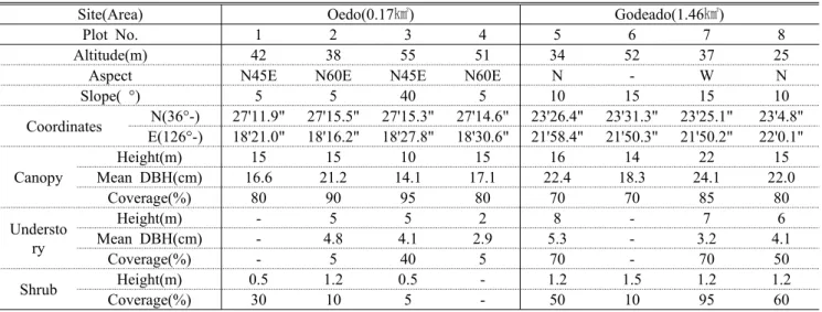
Site(Area) Oedo(0.17㎢) Godeado(1.46㎢)
Plot No. 1 2 3 4 5 6 7 8
Altitude(m) 42 38 55 51 34 52 37 25
Aspect N45E N60E N45E N60E N - W N
Slope( °) 5 5 40 5 10 15 15 10
Coordinates N(36°-) 27'11.9" 27'15.5" 27'15.3" 27'14.6" 23'26.4" 23'31.3" 23'25.1" 23'4.8"
E(126°-) 18'21.0" 18'16.2" 18'27.8" 18'30.6" 21'58.4" 21'50.3" 21'50.2" 22'0.1"
Canopy
Height(m) 15 15 10 15 16 14 22 15
Mean DBH(cm) 16.6 21.2 14.1 17.1 22.4 18.3 24.1 22.0
Coverage(%) 80 90 95 80 70 70 85 80
Understo ry
Height(m) - 5 5 2 8 - 7 6
Mean DBH(cm) - 4.8 4.1 2.9 5.3 - 3.2 4.1
Coverage(%) - 5 40 5 70 - 70 50
Shrub Height(m) 0.5 1.2 0.5 - 1.2 1.5 1.2 1.2
Coverage(%) 30 10 5 - 50 10 95 60
Table 1. General description of the physical and vegetation of the surveyed plots in the major four islands 0.17~3.24㎢로 다양하여 각 섬간의 식생조사의 적정성, 용
이성 및 비교를 위해 각 조사구당 4개씩의 조사구로 통일하 였다. 4개 섬에 대한 본조사는 2009년 7월에 실시되었다.
2. 식생구조조사 및 분석
태안해안국립공원의 4개 섬의 식생 특성을 밝히고자 식 생 조사는 교목층, 아교목층, 관목층으로 나누어 수관층위 별로 조사를 실시하였다. 상층수관을 이루는 수목을 교목층 으로, 수고 2m이하의 수목을 관목층으로, 기타 수목을 아교 목층으로 구분하였다. 교목층과 아교목층에서는 수목을 10m×10m 크기 방형구에서 수목의 높이와 흉고직경을, 관 목층에서는 각 방형구에 5m×5m 크기로 중첩해서 설치한 소형 방형구 1개소에서 수목의 수관폭(장변×단변)을 조사 하였다. 각 조사지의 환경요인은 고도, 방향, 경사도, 식피 율, 수고, 종수 등을 조사하였다.
식생조사 자료를 토대로 각 수종의 상대적 우세를 비교하 기 위하여 Curtis and McIntosh(1951)의 중요치(Importance Value; I.V.)를 통합하여 백분율로 나타낸 상대우점치 (Brower and Zar, 1977)를 수관층위별로 분석하였다. 상대 우점치(Importace Percentage; I.P.)는 (상대밀도+상대피도 +상대빈도수)/3 으로 계산하였으며, 개체들의 크기를 고려 하여 수관층위별로 가중치를 부여한 (교목층 I.P.×3+아교 목층 I.P.×2+관목층 I.P.×1)/6으로 평균상대우점치(Mean Importance Percentage; M.I.P)를 구하였다.
상대우점치 분석 자료를 토대로 4개 섬의 식생들의 관계 적 분포를 알아보기 위하여 DCA ordination(Hill, 1979)분 석을 실시하였다. 식생자료를 토대로 유사도를 비교 분석하 였고, Whittaker(1956)의 수식을 이용하여 유사도지수
(Similarity index=2C/A+B, A=A표본의 종수, B=B표본의 종수, C=두 표본의 공통종수)를 분석하였다. 종다양도분석 은 Shannon의 종다양도(′ ) 분석을 실시
하였다(Pielou, 1975).
결과 및 고찰
1. 조사지 개황
태안해안국립공원의 대표적인 섬인 외도, 고대도, 장고 도, 가의도를 대상으로 각각의 조사구의 일반적 개황을 나 타내었다(Table 1). 4개 섬은 모두 유인도로써 가의도가 가 장 큰 3.24㎢였으며, 고대도(1.46㎢), 장고도(0.70㎢), 외도 (0.17㎢)의 순이었다. 각각의 섬은 물리적 환경이 다양하였 는데 대체로 경사가 급하고 조사구의 방위도 다양하였다.
교목층 및 아교목층의 수고는 식생군락에 따라 다양하였는 데, 교목층의 경우 8~22m범위, 아교목층은 2~10m범위였 다.
각 섬의 식생 층위별로 평균흉고직경을 산출한 결과 (Table 2), 교목층에서 평균흉고직경이 가장 큰 곳은 고대 도>외도>장고도>가의도 순이었으며, 아교목층의 평균흉고 직경은 약 4.2㎝로 비슷하였다.
2. 식생구조
태안해안국립공원 4개 섬의 층위별 상대우점치 평균상대 우점치를 나타낸 것인 Table 3이다. 4개 섬중 가장 면적이 작은 외도의 식생구조에서 교목층은 대부분 곰솔(I.P.
89.0%)(Figure 2)이었으며 부분적으로 소사나무와 소나무
Site Janggodo(0.70㎢) Gauido(3.24㎢)
Plot No. 9 10 11 12 13 14 15 16
Altitude(m) 21 32 31 16 107 146 179 75
Aspect S S30W N30W S30E - - N45W S60E
Slope( °) 10 5 5 - 10 10 20 10
Coordinates N(36°-) 23'52.5" 23'53.2" 23'55.0" 24'0.20" 40'31.7" 40'32.5" 40'34.8" 40'29.9"
E(126°-) 20'59.6" 21'1.60" 20'58.7" 20'47.5" 3'58.9" 3'54.0" 3'52.4" 3'59.9"
Canopy
Height(m) 17 18 20 12 15 12 8 18
Mean DBH(cm) 15.6 14.9 21.4 10.8 19.0 15.9 6.3 19.6
Coverage(%) 60 70 80 80 60 80 95 70
Underst ory
Height(m) 10 7 10 7 7 7 5 8
Mean DBH(cm) 4.7 4.2 5.9 3.0 6.4 4.0 2.7 4.1
Coverage(%) 40 30 70 20 70 50 40 80
Shrub Height(m) 1.2 1.2 2 0.8 1.0 1.5 0.8 1.2
Coverage(%) 30 60 60 8 40 30 10 20
Table 1. (Continued)
Site Mean DBH(㎝)
Tree Subtree
Oedo 17.6 4.2
Godaedo 21.6 4.1
Janggodo 14.6 4.2
Gauido 10.6 4.2
Total Mean DBF 15.3 4.2
Table 2. Mean DBH of each island
Figure 2. Pinus thunbergii community in Oedo Figure 3. Pinus densiflora community in Godaedo 가 관찰되었다. 아교목층에서는 고로쇠나무(I.P. 46.2%), 팥
배나무(I.P. 13.8%), 노린재나무, 뽕나무 등이 관찰되었고, 관목층에서는 곰딸기(I.P. 28.6%), 초피나무(I.P. 20.6%), 풍게나무(I.P. 16.3%)가 분포하고 있었다.
고대도의 식생은 외도와 달리 교목층에서 곰솔(I.P.
69.6%)과 소나무(I.P. 30.5%)(Figure 3)가 더불어 분포하는 있었다. 아교목층에서는 산벚나무(I.P. 34.3%), 굴피나무 (I.P. 28.5%)가 우점종이었고, 관목층에서는 진달래(I.P.
42.2%)가 가장 넓게 분포하고 있었다.
장고도의 식생구조에서 교목층은 곰솔이 상대우점치 98.5%로 우점종(Figure 4)이었으며, 일부 굴피나무(I.P.
1.5%)가 출현하고 있었다. 아교목층에서도 곰솔(I.P.
57.5%), 졸참나무(I.P. 10.0%), 산벚나무(I.P. 8.9%), 굴피 나무(I.P. 7.7%) 등이, 관목층에서는 진달래(I.P. 17.4%)와 졸참나무(I.P. 14.3%)가 가장 넓게 분포하고 있었다.
4개 섬 중 가장 크기가 큰 가의도 식생구조에서는 교목층 에서 다른 3개 섬과 달리 곰솔보다는 소나무(I.P. 44.8%), 소사나무(I.P. 39.5%)(Figure 5) 등이 우점종이었다. 아교목 층에서는 소사나무(I.P. 60.8%), 굴피나무(I.P. 15.3%)가 가
Site1 Layer
Species C2 U S M Layer
Species C U S M
Ⅰ
Pinus thunbergii 89.0 0.0 0.0 44.5 Styrax japonicus 1.0 0.0 8.4 1.9
Acer pictum subsp. mono 2.6 46.2 0.0 16.7 Morus bombycis 0.0 0.0 8.6 1.4
Sorbus alnifolia 1.7 13.8 0.0 5.4 Carpinus turczaninovii 2.9 0.0 0.0 1.4
Zanthoxylum piperitum 0.0 4.6 20.6 5.0 Pinus densiflora 1.5 0.0 0.0 0.8
Rubus phoenicolasius 0.0 0.0 28.6 4.8 Fraxinus mandshurica 1.3 0.0 0.0 0.7
Symplocos chinensis for. pilosa 0.0 11.6 0.0 3.9 Pueraria lobata 0.0 0.0 3.7 0.6
Morus alba 0.0 11.2 0.0 3.7 Ampelopsis brevipedunculata 0.0 0.0 3.6 0.6
Celtis jessoensis 0.0 0.0 16.3 2.7 Cudrania tricuspidata 0.0 0.0 2.9 0.5
Albizia julibrissin 0.0 8.0 0.0 2.7 Smilax china 0.0 0.0 1.8 0.3
Callicarpa japonica 0.0 4.6 5.5 2.5
Ⅱ
Pinus thunbergii 69.6 1.6 0.6 35.4 Indigofera kirilowii 0.0 0.0 3.1 0.5
Pinus densiflora 30.5 5.1 0.0 16.9 Berberis amurensis 0.0 0.0 3.0 0.5
Prunus sargentii 0.0 34.3 8.9 12.9 Callicarpa japonica 0.0 0.0 2.2 0.4
Platycarya strobilacea 0.0 28.5 1.3 9.7 Celtis sinensis 0.0 1.1 0.0 0.4
Rhododendron mucronulatum 0.0 0.0 42.2 7.0 Styrax japonicus 0.0 0.0 1.6 0.3
Lindera obtusiloba 0.0 6.8 1.8 2.6 Celastrus orbiculatus 0.0 0.0 1.1 0.2
Quercus aliena 0.0 5.8 3.2 2.5 Rosa multiflora 0.0 0.0 1.0 0.2
Quercus serrata 0.0 5.2 2.9 2.2 Parthenocissus tricuspidata 0.0 0.0 0.9 0.2
Symplocos chinensis for. pilosa 0.0 1.6 5.5 1.4 Lonicera caerulea var. edulis 0.0 0.0 0.5 0.1
Quercus dentata 0.0 4.3 0.0 1.4 Akebia quinata 0.0 0.0 0.5 0.1
Viburnum erosum 0.0 1.3 5.3 1.3 Zanthoxylum piperitum 0.0 0.0 0.5 0.1
Sorbus alnifolia 0.0 2.4 1.8 1.1 Ligustrum obtusifolium 0.0 0.0 0.5 0.1
Picrasma quassioides 0.0 0.0 6.2 1.0 Euonymus pauciflorus 0.0 0.0 0.6 0.1
Rhus tricocarpa 0.0 2.3 1.6 1.0 Symplocos tanakana 0.0 0.0 0.4 0.1
Elaeagnus glabra 0.0 0.0 3.3 0.5
Ⅲ
Pinus thunbergii 98.5 57.5 8.9 69.9 Euonymus japonicus 0.0 2.1 0.0 0.7
Quercus serrata 0.0 10.0 14.3 5.7 Elaeagnus macrophylla 0.0 0.0 4.2 0.7
Platycarya strobilacea 1.5 7.7 0.0 3.3 Albizia julibrissin 0.0 1.4 1.2 0.7
Prunus sargentii 0.0 8.9 0.0 3.0 Styrax japonicus 0.0 1.4 0.0 0.5
Rhododendron mucronulatum 0.0 0.0 17.4 2.9 Euonymus pauciflorus 0.0 1.1 0.0 0.4
Symplocos tanakana 0.0 2.5 8.9 2.3 Sorbus alnifolia 0.0 0.9 0.0 0.3
Cudrania tricuspidata 0.0 3.0 7.1 2.2 Juniperus rigida 0.0 0.8 0.0 0.3
Rhus tricocarpa 0.0 0.9 9.2 1.8 Koelreuteria paniculata 0.0 0.0 1.3 0.2
Rubus phoenicolasius 0.0 0.0 9.2 1.5 Rhus javanica 0.0 0.0 1.1 0.2
Lindera obtusiloba 0.0 1.8 5.7 1.5 Zanthoxylum piperitum 0.0 0.0 0.8 0.1
Viburnum erosum 0.0 0.0 4.7 0.8 Smilax sieboldii 0.0 0.0 0.8 0.1
Lonicera caerulea var. edulis 0.0 0.0 4.4 0.7 Smilax china 0.0 0.0 0.7 0.1
Ⅳ
Carpinus turczaninovii 39.5 60.8 0.0 40.0 Sorbus alnifolia 1.3 0.9 0.0 0.9
Pinus densiflora 44.8 0.0 0.0 22.4 Trachelospermum asiaticum 0.0 0.0 5.3 0.9
Platycarya strobilacea 1.9 15.3 0.0 6.1 Viburnum wrightii 0.0 0.0 3.9 0.7
Viburnum erosum 0.0 1.8 16.8 3.4 Lindera erythrocarpa 0.0 0.0 3.3 0.5
Lindera obtusiloba 0.0 0.6 17.8 3.2 Euonymus pauciflorus 0.0 0.0 2.8 0.5
Lespedeza maximowiczii 0.0 0.0 18.7 3.1 Ligustrum obtusifolium 0.0 0.0 2.1 0.4
Pinus thunbergii 5.9 0.0 0.0 3.0 Celtis koraiensis 0.0 0.0 1.8 0.3
Picrasma quassioides 0.7 4.4 1.1 2.0 Lindera glauca 0.0 0.8 0.0 0.3
Quercus dentata 0.7 4.3 0.0 1.8 Rhamnus davurica 0.0 0.6 0.0 0.2
Rhododendron mucronulatum 0.0 4.4 1.8 1.8 Fraxinus rhynchophylla 0.0 0.6 0.0 0.2
Elaeagnus macrophylla 0.0 0.0 10.4 1.7 Zanthoxylum piperitum 0.0 0.0 1.1 0.2
Quercus variabilis 2.4 1.5 0.0 1.7 Kalopanax septemlobus 0.0 0.0 1.1 0.2
Smilax china 0.0 0.0 9.6 1.6 Pourthiaea villosa 0.0 0.5 0.0 0.2
Prunus sargentii 0.7 3.0 0.9 1.5 Celtis sinensis 0.0 0.0 0.9 0.2
Quercus serrata 2.1 0.8 0.0 1.3 Smilax sieboldii 0.0 0.0 0.9 0.2
1 Ⅰ: Oedo, Ⅱ: Godaedo, Ⅲ: Janggodo Ⅳ: Gauido.
2 C: Importance percentage in canopy layer, U: Importance percentage in understory layer, S: Importance percentage in shrub layer, M: Mean importance percentage
Table 3. Importance percentage of woody species by stratum in four islands
Figure 4. Pinus thunbergii community in Janggodo Figure 5. Carpinus turczaninovii community in Gauido
Site Oedo Godaedo Janggodo
Godaedo 39.41
Janggodo 48.19 50.99
Gauido 6.58 38.13 14.92
Table 4. Similarity index among four islands at the Taeanhaean National Park
Figure 6. DCA(detrended correspondence analysis) ordination analysis of 4 islands at the Taeanhaean National Park(Oedo(●), Godaedo (■), Janggodo(▲), Gauido(◆)).
장 많이 조사되었고, 관목층에서는 조록싸리(I.P. 18.7%), 생강나무(I.P. 17.8%), 덜꿩나무(I.P. 16.8%), 보리밥나무 (I.P. 10.4%) 등이 우점종이었다.
이상 태안해안국립공원의 대표적인 4개 섬에 대한 식생 구조를 살펴본 결과 가의도에서는 소나무가 우점종으로, 고 대도에서는 곰솔이 우세한 가운데 소나무가 출현하였고, 외 도와 장고도는 거의 곰솔림의 군락유형을 보였다. 단, 각 섬의 임상을 고려하여 섬의 식생을 대표할 수 있도록 섬 별로 조사구가 설치되어 조사구별 세부 비교보다는 해당 섬간 비교에 본 연구의 초점이 맞춰져 있음에 유의할 필요 가 있다.현재 우리나라 동, 남, 서해안의 대표적인 해안림은 자연적이든 방풍의 목적을 위해 기능적으로 식재한 것이든 곰솔림이 우세하고, 남, 서 연안에 위치한 섬들도 곰솔림이 대부분 우점종이다(Oh et al., 1999; Lee et al., 1999a, 1999b; Woo, 2003; Kim and Choi, 2007; Park et al., 2009). 따라서 본 연구의 결과는 우리나라 해안 및 도서지역 식생과 관련하여 태안해안국립공원의 주요 도서의 식생구 조를 밝히는 의의가 있다 할 것이다.
3. Ordination 및 유사도 분석
방대한 자료를 관계적으로 정렬시켜 자료를 단순하게 압 축한 것이 ordination분석의 목적이라 할 수 있다(Ludwig and Reynolds, 1988). 태안해안국립공원 4개 섬에 대한 식 생특성의 관계적 상관성을 파악하기 위하여 ordination분석
중 DCA분석을 실시한 것이 Figure 6이고, 4개 섬의 식생간 유사도지수 분석을 실시한 것이 Table 4이다.
유사도분석 결과 외도와 가의도의 유사성은 6.58%로 4 개 섬간 유사성에 있어서 가장 상이성이 높았고 장고도와는 14.92%로 그 뒤를 이었다. 이는 ordination분석 결과와도 일치하여 ordination분석결과 곰솔이 우점종인 외도는 제1 축의 왼쪽에 소나무와 소사나무가 우점종인 가의도는 오른 쪽으로 분포하였다. 가장 유사도가 높은 섬은 고대도와 장 고도로 50.99%의 유사성을 보였다. 이러한 결과는 4개 섬
Site No. of individuals No. of species
Tree Understory shrub Total Tree Understory shrub Total
Oedo 17.3±5.7 3.3±4.0 35.0±31.2 55.5±31.4 2.3±2.5 2.0±1.8 3.3±2.2 6.8±1.0 Godaedo 11.8±1.5 14.0±9.8 148.0±142.5 173.8±144.1 1.5±0.6 4.8±3.4 9.8±2.8 13.0±4.2 Janggodo 20.3±6.7 18.0±5.1 75.0±49.6 113.3±39.8 1.3±0.5 4.0±2.0 6.8±3.3 9.8±5.1 Gauido 21.5±21.8 25.3±4.3 70.0±28.0 116.8±19.4 3.5±1.3 5.8±1.3 7.5±2.1 13.8±2.1 Table 6. Mean analysis of the number of species and individuals of 4 islands in the Taeanhaean National Park
(Unit: 100㎡) Site H'(shannon1) Simpson' P.I.E.2 J'(evenness) D'(dominance) H'max
Oedo 2.2937 7.2814 0.8627 0.7790 0.2210 2.9444
Godaedo 2.5409 6.2239 0.8393 0.7546 0.2454 3.3673
Janggodo 2.3710 6.5081 0.8463 0.7461 0.2539 3.1781
Gauido 2.7183 9.9270 0.8993 0.7992 0.2008 3.4012
1 Shannon's diversity index uses logarithms to base e.
2 P.I.E. = the Probability of Interspecific Encounter
Table 5. Species diversity analysis of four islands at the Taeanhaean National Park(Unit: 400㎡)
의 식생구조가 교목층은 물론 아교목층 및 관목층에서 4개 섬의 물리적 환경의 다양성으로 말미암아 식생구조가 상이 함을 나타내는 것이다.
4. 종다양도 및 종수․개체수 분석
태안해안국립공원 4개 섬의 종다양도에 따른 식생구조 특성을 밝힌 것이 Table 5이다. 출현종수를 반영한 최대종 다양도 및 Shannon의 종다양도가 가장 높은 곳은 가의도로 2.7183이었다. 이는 가의도의 식생구조가 출현종수도 많았 지만 우점도가 낮아 출현종들이 비교적 균등하게 분포하고 있기 때문이다. 가장 종다양도가 낮은 섬은 가의도로써 출 현종수가 적었다.
Table 6은 4개 섬의 종수 및 개체수 분석을 실시한 것이 다. 개체수분석에서 교목층은 가의도가 21.5±21.8개체, 장 고도 20.3±6.7개체순으로 많았으나 가의도는 식생에 따라 개체수의 편차가 컸다. 가의도는 아교목층의 개체수도 25.3±4.3개체로 나머지 3개 섬보다 많았다. 이는 가의도를 제외한 식생이 곰솔이나 소나무군락인 반면 가의도는 소사 나무군락으로 구성되었기 때문으로 사료된다. 종수분석에 서는 가의도 및 고대도 순으로 종수가 많았다. 층위별로는 교목층에서 가의도와 외도 순이었으며, 아교목층에서는 가 의도와 고대도순이었다.
인용문헌
Ahn, Y.H.(2003) Phytosociological Study on the Vegetation of
Sand Dune in Shindoori Seashore. J. Korean Env. res. & Reveg.
Tech 6(6): 29-40.
Brower, J. E. and J. H. Zar(1977) Field and Laboratory Methods for General Ecology. Wm. C. Brown Company, 194pp.
Choi, C.H., B.S. Seo, W.J. Park and S.H. Park(2006) The Flora of Coastal Duen Area in Shinduri, Korea. Korean J. Plant Res.
19(2): 209-217.
Curtis, J.T. and R.P. McIntosh(1951) An upland forest continuum in the prairie-forest border region of Wisconsin. Ecology 32:
476-496.
Hill M.O.(1979) DECORANA - a FORTRAN program for de- trended correspondence analysis and reciprocal averaging -.
Ecology and Systematics, Cornel Univ., Ithaca, New York, 52pp.
Kim, C.H., K.S. Lee and K.H. Park(1982) An Ecological Study on the Flora of Bijin Island. Korean J. Ecol. 5(4): 164-175.
Kim, I.T., J.H. Lee and T.G. Jin(2000a) The Vegetation of Maemul, Somaenum and Eoyu Islets. Korean J. Ecol. 23(3): 217-222.
Kim, I.T., J.H. Lee and T.G. Jin(2000b) The Vegetation of Hansan and Chubong Islets. Korean J. Ecol. 23(5): 391-395.
Kim, J.H., D.S. Cho, K.J. Cho and B.M. Min(1984) An Ecological Study on the Evergreen Broadleaved Forest of Jisimdo. Korean J. of Botany. 27(2): 51-60.
Kim, S.H. and S.H. Choi(2007) The Structure and Ecological Characteristics of Coastal Forest in Busan Metropolitan City.
Kor. J. Env. Eco. 21(1): 67-73.
Kim, S.H., J.C. Seo and K. Park(2008) The Classification of Coastal Dune Wetlands in the Shindu Dunefield Based on Their Topographic and Hydrologic Characteristics. Journal of the
Korean Geomorphological Assocation 15(3): 107-118.
Kim, Y.G.(1994) A Survey on the Environmental Substances for Environmental Preservation of Tae-An Seashore National Park. Korean J. Sanitation 9(2): 72-87.
Korea National Parks Service(KNPS) Taeanhaean Office(1997) Natural Ecosystem Conservation Plan of Taeanhaean National Park. 103pp.
Korea National Parks Service(KNPS)(2006) Resource monitoring of the Taeanhaean National Park: The 1st Year. 326pp.
Korea National Parks Service(KNPS)(2010) http://www.knps.or.kr Lee, K.J., B.H. Han and J.Y. Kim(1999b) Plant community struc- ture & distribution density of Pinus thunbergii-Pinus densi- flora Forest in Kojedo district, Hallyo-Haesang National Park.
Kor. J. Env. Eco. 12(4): 361-372.
Lee, K.J., B.H. Kim and D.W. Kim(1999a) Vegetation structure and ecological succession of Kojedo district, Hallyo-Haesang National Park. Kor. J. Env. Eco. 12(4): 331-344.
Ludwig, J.A. and J.F. Reynolds(1988) Statistical Ecology. John Wiley & Sons Inc., 337pp.
Ministry of Land, Transport and Maritime Affairs(MLTM)(2010) http://www.mltm.go.kr/
National Science Museum(NSM)(1995) Ecosystem Study of Taeanhaean National Park. 214pp.(in Korean).
National Science Museum(NSM)(2005) Study on a History of
National Park: Taeanhaean National Park History Study.
160pp.(in Korean).
Oh, H.K., Y.H. Kim and W.K. Lee(2005) Studies on the Vascular Plants of the Seashore Baeklipo-Uihangri, Taean Peninsula.
The Journal of Korean Institute of Forest Recreation. 9(2):
37-46.
Oh, H.K., Y.H. Kim, M.S. Beon and J.M. Park(2005) A Study on Flora of the Shindoo-ri Coastal Dune. The Journal of Korean Institute of Forest Recreation. 9(1): 37-48.
Oh, K.K., G.C. Choo and Y.K. Jee(1999) Actual Vegetation and Vegetation Structure of Tongyoung District in Hallyo-Haesang National Park. Kor. J. Env. Eco. 12(4): 317-330
Park, C.M., S.W. Kim and S.H. Park(2009) Study on Growth Characteristics of Pinus thunbergii Windbreak Forests around Goosipo Beach, Gochang-Gun. Kor. J. Env. Eco. 23(4):
365-375.
Pielou, E.C.(1975) Ecological Diversity. John Wiley & Sons Inc., 165pp.
Whittaker, R.H.(1956) Vegetation of the Great Smoky Mountains.
Ecological Monographs 26: 1-80.
Woo, B. M.(2003) Environmental Restoration and Revegetation Engineering. Seoul National University, Seoul, 558pp.
Yim, Y.J. and W.T. Lee(1976) On the Vegetations of Judo and Gamagseum. Korean Jour. Botany 19(2): 49-61.