1. INTRODUCTION
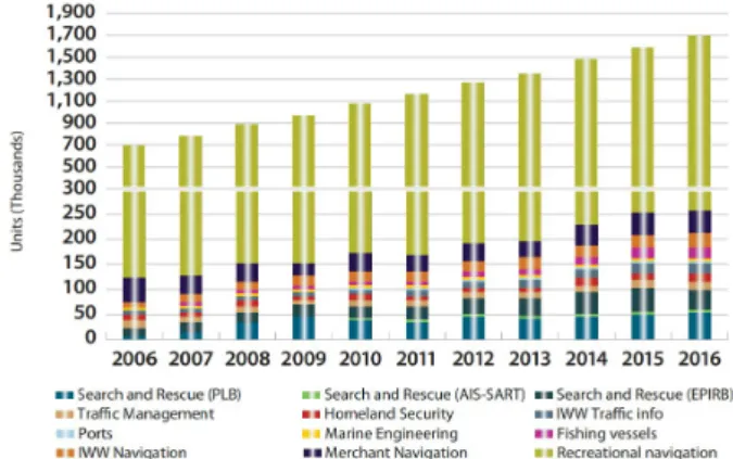
Recently, the market for maritime location-based services is expanding year after year. In particular, the marine GNSS market for small and leisure vessels is rapidly increasing every year and their market share is increasing as well (Fig. 1).
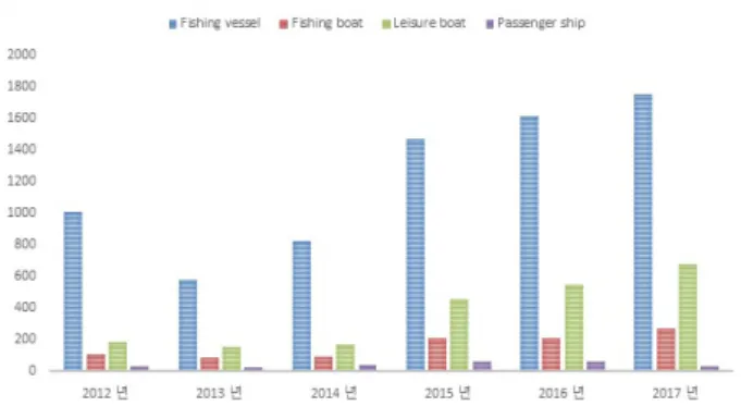
Although GNSS market is growing due to the increase of leisure vessels around the world, accidents are also increasing because of the difficulties of installing precise navigation equipment. According to the Korea Coast Guard’s maritime disaster statistics(Korea Coast Guard 2017, Korean Statistical information Service 2018), an average of 2,140 marine accidents
The Comparison and Analysis of Maritime Precise Positioning using GPS Based Smartphone
Sul Gee Park
†, Sang Hyun Park
Maritime Safety and Environment Research Division, Korea Research Institute of Ships and Ocean engineering, Daejeon 34103, Korea
ABSTRACT
According to the Korea Coast Guard’s maritime disaster statistics (Korea Coast Guard 2017, Korean Statistical information Service 2018), an average of 2,140 marine accidents occurred every year for the past 6 years and the number of accidents is increasing every year. Among them, maritime accidents of fishing vessels are the most frequent, and recently accidents involving fishing boat and leisure vessels are rapidly increasing as well. In particular, the number of accidents involving leisure vessels increased to about one-third of the accidents of fishing vessels, and emergency rescue requests are increasing every year accordingly. However, the number of crash accidents involving users of small vessels and marine leisure activities are increasing because of the difficulties of installing navigation equipment and electronic navigation charts. Recently, the demand for precise positioning using mobile devices is increasing in the fields of maritime safety, piloting support, and coastal survey. Although various applications of smart devices provide location-based services for users, the measurement results are discontinuous when using the position coordinates of the National Marine Electronics Association (NMEA) calculated by smartphone. Recently, Google announced that they will provide GPS raw data to developers from Android 7.0 Nougat.
As a result, developers have an opportunity to receive precise carrier phase and code measurements to make more accurate positioning according to the performance of Android devices. This study analyzed GPS positioning performance using Android devices, and compared and analyzed the positioning performance at sea with high-performance GPS receivers.
Keywords: smartphone, android positioning, android carrier phase measurement, maritime precise positioning
occurred every year from 2012 to 2017 and the number of accidents is increasing year after year (Fig. 2). Although
Received Oct 16, 2018 Revised Oct 24, 2018 Accepted Nov 02, 2018
†
Corresponding Author E-mail: [email protected]
Tel: +82-42-866-3685 Fax: +82-42-866-3689
Fig. 1. GNSS unit shipments by application (GSA GNSS market report
2017).
maritime accidents of fishing vessels are the most common, the number of accidents involving fishing boat and leisure vessels has increased rapidly each year. In particular, the number of accidents involving leisure vessels increased to about one- third of the accidents of fishing vessels. However, it is difficult to prevent collisions and request emergency rescue because of the difficulties of installing navigation equipment and electronic navigation charts in small and leisure vessels in Korea. In addition to maritime accidents, the demand for precise navigation and positioning using mobile devices is increasing in the fields of piloting support and coastal survey. Although various applications of smart devices provide location-based services for the various needs of users, the measurement results do not guarantee continuity in dynamic environments, and it is difficult to apply various correction information and position performance algorithms in the location area.
Recently, Google announced that they will provide GPS raw data to developers from Android 7.0 Nougat. As a result, developers have an opportunity to receive precise carrier phase and code measurements to make more accurate positioning according to the performance of Android devices. Riley et al. (2017) compared the performance of Trimble’s Catalyst mobile platform and Android devices to compare geodetic systems using Android devices. As a result, the study confirmed that cycle slips frequently occurred when using the signal-to-noise ratio and carrier phase measurements according to the type of smart devices, and also confirmed that the accuracy of GPS-alone horizontal positioning is within 10 m. Banville & van Diggelen (2016)
Android devices. In particular, most of the studies were based on land and air platforms, and were focused on carrier-based relative positioning techniques.
This paper analyzed maritime positioning performance using Android devices at sea. Chapter 2 analyzed the characteristics of satellite signals of Android devices, Chapter 3 compared the results of stand-alone and precision positioning, and Chapter 4 analyzed the experimental results at sea.
2. ANDROID SATELLITE SIGNAL CHARACTERISTICS
Currently, devices with Android 7.0 or higher provide Pseudo-range, Navigation message, Accumulated delta range, and Hardware clock information to developers. Table 1 is a list of GNSS raw data currently available on Android devices (Google Developer 2018).
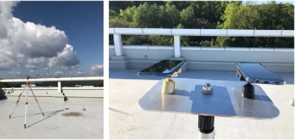
In this paper, we used a Samsung S9 smartphone to analyze Android-based raw data, and the device was installed as shown in Fig. 3 to collect constant raw data for 2 hours on October 11, 2018, using Google’s GNSS Logger application.
In this paper, we used NovAtel’s DL-V3 high-performance receiver to compare the characteristics of Android-based raw data. Figs. 4 and 5 compares the signal-to-noise ratio of the high-performance receiver and Android device. Fig. 4 shows the signal-to-noise ratio over time, where the High- performance receiver shows a range from 40 dB-Hz to 52 dB- Hz, while the Android device shows a range from 30 DB-Hz
Table 1. Specific device support raw GNSS measurements (GLO: GLONASS, GAL: GALLILEO, BD: BEIDOU, QZ: QZSS).
Model Android version Navigation message Accumulated delta range HW clock Global systems
Huawei mate 10 Pro
Google pixel 2 Samsung note 8 Samsung S8 LG V30 Hauwei P10 Nexus 9
8.0 8.0 7.1 7.0 7.1.2
7.0 7.1
yes no yes yes no yes yes
yes no yes yes no yes yes
yes yes yes yes yes yes yes
GPS, GLO
GPS, GLO,GAL, BD, QZ GPS, GLO, GAL, BD GPS, GLO, GAL, BD, QZ GPS, GLO
GPS, GLO, GAL, BD, QZ
GPS, GLO
Fig. 3. Experimental setup.
Fig. 4. Novatel and android C/N0. (a) NovAtel (b) Android
(a) (b)
Fig. 5. Novatel and android C/No versus elevation angle. (a) NovAtel (b) Android
(a) (b)
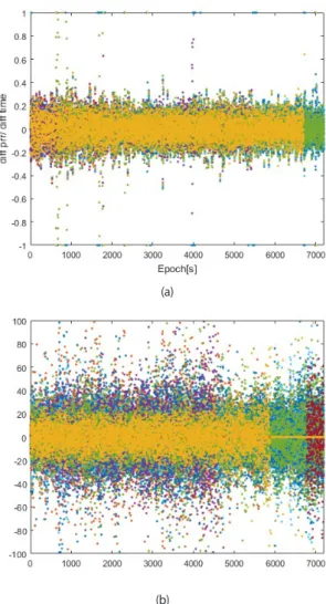
ratio than the high-performance receiver. Fig. 5 shows the signal-to-noise ratio according to elevation angle, where the signal-to-noise ratio of the Android device was not good even the elevation angle was high. The high-performance receiver showed higher signal-to-noise ratios as the elevation angle increased and lower ratios as the elevation angle decreased, and there was no significant difference in the signal-to-noise ratio at the same elevation angle. However, the Android device showed a high signal-to-noise ratio as the elevation angle decreased. This is caused by the poor antenna performance of Android device because it is vulnerable to multipath, and presents a large error in measurement noise.
The data collected in this paper showed a low signal-to-noise ratio despite the high elevation angle, which is expected to affect the navigation performance. This is the data characteristics according to a specific date and surrounding environment, and because Android device is exposed to a high-level of multipath and noise, the location performance is significantly reduced and noise must be removed through various methods.
3. POINT POSITIONING ANLAYSIS
Android does not provide pseudo-range directly to developers as raw measurements, so the satellite signal transmission time and user signal received time needs to be calculated based on the raw measurements provided.
The received time can be calculated using TimeNaNos, TimeOffsetNanos, FullGiasNonos, BiasNanos, and WeekNumberNonos provided by Android device. The WeekNumber can be calculated as shown in Eq. (1), and the reception time as shown in Eq. (2).
( )
(
. 1 9 / tan .)
weekNumber floor double gnssRaw FullBiasNonos= − ∗ −e GpsCons tsWEEKSEC
(1)
( ) ( )
Rxtime TimeNonos TimeOffsetNanos= + −FullBiasNanos BiasNonos WeekNumberNanos+ −