A Study on the Layout Patterns of Public Schools in Manhattan - Focused on Relationship between Manhattan Grid Plan and Open Space -
12
0
0
전체 글
(2) 김필수․전유창. layout for campuses. This study will make a theoretical. relationship between the building site and the street, the. examination of layout types based on education, school. direction of the buildings and their main entrances,. facilities, and local communities. It will then provide. frontality of the buildings, outdoor space, and open space.. suggestions on how the layout of schools can meet the. Through such categorization, the study identified various. social demands of cityscapes with a street grid system.. manifestations of spatial continuity between the indoors. This study examined how the layouts of educational. and the outdoors of the buildings, and noted how each. facilities can affect, or can be affected by, the charac-. type integrates the open space with the surrounding streets.. teristics of the open space and street by integrating the. Lastly, the study highlighted several schools that. buildings into the urban landscape.. prominently make use of the Manhattan grid plan in their. In particular, this study examined extant examples in. layouts, and analyzed their correlations with the community. Manhattan, where a grid of streets outlines various blocks. school district, block types, topography, outdoor space, and. that allow for different layouts of open spaces in each. elements related to the streets.. district. Through bibliographical research and on-site surveys, the study specifically categorized and analyzed the environmental layout and circulation of 118 public. 2. Manhattan'S Urban Characteristics and Gird Plan. primary and secondary schools built in Manhattan under the guidance of the School Construction Authority(SCA)1).. 2.1 The commissioner plan of 1811. The analysis will help identify the types of relationships. In the early years of New York City, Manhattan’s. between the open campus space and the streets of. southernmost area formed the heart of the city, bustling. Manhattan’s grid plan.. with residential areas, warehouses, wharfs, churches, and. The ultimate purpose of this study is to provide a case. government facilities. As fires were common during that. study for future efforts to plan open spaces for campuses. era, many facilities gradually relocated northward. However,. that effectively utilize the streets in proximity.. due to the lack of specific guidance on urban development, the new buildings were constructed in a disorderly array.. 1.2 Subject and Methodology. This can be seen in the lower part of 14th Street where. This study used spatial analysis to examine Manhattan. various grids and vertices overlap without any particular. public schools. The methodology used herein was as. plan. Moreover, New York in the early 19th century. follows: first, refer to precedent literature for the charac-. experienced rapid growth in economy, population, and. teristics of Manhattan’s grid plan and the background. number of immigrants from Europe. Such conditions. behind the selection of the schools’ locations, as well as. necessitated expansion of real estate and residential. any policies that underpinned such decisions; second, visit. facilities, leading the State of New York to appoint a. 118 of Manhattan’s public schools to collect data on the. three-member council in 1807, declaring:. status of public elementary schools’ open spaces that utilize their streetside disposition or any plans to do so;. “laying out streets... in such a manner as to unite. and third, determine the characteristics of the surroun-. regularity and order with the public convenience and. dings and building site of the subject areas to categorize. benefit and in particular to promote the health of the. building layout types according to the topography, the. City....”. 1) The School Construction Authority(SCA) was established by the New York State Legislature in December 1988 to build new public schools and manage the design, construction and renovation of capital projects in New York City's more than 1,200 public school buildings, half of which were constructed prior to 1949.. 4 한국교육시설학회논문집 제20권 제2호 통권 제93호 2013년 3월. In 1811, the council published the Commissioner's Plan of 1811 upon the approval of the State and the City. The plan proposed 12 north-south avenues above Houston Street, with 155 streets crossing the avenues from east to.
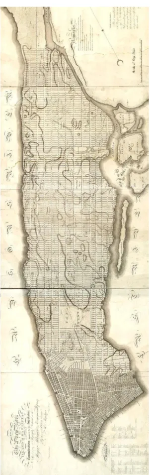
(3) 뉴욕시 공립학교에 나타난 배치 특성에 관한 연구. west. As an exception, Broadway crosses the grid diagonally from northwest to southeast. Governor Morris explained the reasoning behind the grid system in the Commissioner’s Plan, saying, “a city is to be composed principally of the habitations of men, and that straightsided and right-angled houses are the most cheap to build and the most convenient to live in.” 2.2 Role of the Grid Plan in Capitalism, Commerce, Population Increase, and Urban Expansion The grid plan offered the possibility of maximizing real estate value while providing efficient and cheap residential space. Despite the high density of the city, the grid plan allowed for improved ventilation of the city with the two rivers hugging the land. Meanwhile, the high-density population helped promote the diversity and street culture of New York. The rather abstract concept of a grid deviated from the traditional perception of the city as a physical space, while the numbered streets and avenues provided a clear sense of orientation in the grid system. Such new concepts provided a comprehensively new perception of a city. Manhattan brought life to a banal, unsentimental, and two-dimensional grid system through its ethnic and cultural diversity, while also physically vitalizing the cityscape through its early zone regulation that helped three-dimensionally embellish the skyline with buildings of varying heights. 2.3 Manhattan Avenue and Street The north-south avenues are numbered from 1 to 12, starting with the eastern most 1st Avenue and ending with the western most 12th Avenue. Each avenue is 30m wide, allowing for bidirectional vehicular traffic. As much of the commerce at the time occurred at the water front, the outermost avenues were set slightly narrower than the inner ones. The avenues in the center of the island were set to be 281m wide, while the waterfront avenues were set slightly closer at 240m. The length of four avenues is approximately 1.6km. Figure 1. A modern redrawing of the 1807 version of the Commissioner's Grid plan for Manhattan, a few years before it was adopted in 1811. Central Park is absent.. In contrast to the varying dimensions of the avenues, the streets form a regular grid of 20m-wide and 60m-long 한국교육시설학회논문집 제20권 제2호 통권 제93호 2013년 3월 5.
(4) 김필수․전유창. blocks from 1st Street to 155th Street. In consideration of the heavy traffic across the eastern and western parts of the island, 14th, 23rd, 34th, 42nd, 57th, 72nd, 79th, 86th, 96th, 106th, 116th, 125th, 135th, 145th and 155th Streets were set to be wider than the remaining streets. The length of 20 blocks is approximately 1.6km(1 mi).. Figure 3. Extended Manhattan Grid as Open Space. streetside building,”2) rather than functioning merely as a road. While it would be most desirable to have streets become venues for social activities, the form and function of the street will vary according to the values of the cultural group to which the users of the given street belong. Some schools in Manhattan have taken advantage Figure 2. Block and Lots. 2.4 Streets of Manhattan and Their Meaning The streets of Manhattan serve as the host of social interaction comprising a wide range of ethnicities and events. Street activities occur when many pedestrians are able to use the streets in a variety of ways. A street not only connects one place to another, but is also a place in and of itself. In other words, a street can host urban activities as both the means of transit and as a place of its own. In the street, local denizens directly express their culture. of the potential of the street as a place of cultural exchange by effectively utilizing the traits and nature of adjacent streets to expand their open space into the grid. Exemplary cases may feature uninhibited entry into school grounds thanks to the lack of visible boundaries, streets that double as plazas, and sharing the streets with the local community to promote exchange between the school and the community.. 3. Traits of Public Schools in Manhattan 3.1 Manhattan Public School System. and sentiments. The unique traits of a given street tend to result from the culmination of the cultural potential of the. New York City School District. Manhattan School District. area, representing the spirit and culture of the area. As such, streets serve not only as channels of human and vehicular traffic, but also as providers of cultural index that greatly influence the look and feel of the buildings and cityscape of the area. Streets thus provide an important venue of experience crafted by the time people spend there. Starting in the modern age, streets have mainly served as channels of vehicular traffic or pedestrian passage, rather than as functional spaces. However, the streets of. Figure 4. School District Diagram. Manhattan are most vibrant when “each person walking on the street comes into extensive contact between each 6 한국교육시설학회논문집 제20권 제2호 통권 제93호 2013년 3월. 2) garrett eckbo, 도시조경계획, 동명사, 1975, p.17.
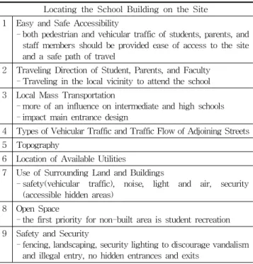
(5) 뉴욕시 공립학교에 나타난 배치 특성에 관한 연구 Table 1. SCA Building Location and Orientation Guidelines. There are 246 public schools in Manhattan, comprising. Locating the School Building on the Site. 111 elementary schools, 44 middle schools, 76 high schools, 1. Easy and Safe Accessibility - both pedestrian and vehicular traffic of students, parents, and staff members should be provided ease of access to the site and a safe path of travel. 2. Traveling Direction of Student, Parents, and Faculty - Traveling in the local vicinity to attend the school. 3. Local Mass Transportation - more of an influence on intermediate and high schools - impact main entrance design. can be served by the city facilities. For example, the. 4. Types of Vehicular Traffic and Traffic Flow of Adjoining Streets. campus of New York University is fully integrated within. 5. Topography. Manhattan, and the campus’s vague boundaries make. 6. Location of Available Utilities. 7. Use of Surrounding Land and Buildings - safety(vehicular traffic), noise, light (accessible hidden areas). and 15 special schools. As previously mentioned, Manhattan’s grid system plays a noteworthy role in facilitating the social and cultural expansion of the city. Most small Manhattan schools are in close enough proximity to make full use of nearby public facilities, thus conserving valuable resources required for programs that. Manhattan itself the de facto campus area. Public schools in Manhattan make active use of city museums, libraries and parks in their curricula, providing the students with a more familiar learning environment within the urban community. Public schools also play an important role in the community life. They not only provide the functional. and. air,. security. 8. Open Space - the first priority for non-built area is student recreation. 9. Safety and Security - fencing, landscaping, security lighting to discourage vandalism and illegal entry, no hidden entrances and exits. benefit of facilities such as gyms, auditoriums, and. This is because the school buildings mingle with the. libraries, but also offer the open spaces and recreational. surrounding buildings, influencing the school’s roles in the. venues that flavor the otherwise starkly compact city grid. community, both educational and otherwise.. filled with solids(architectural structures).. In addition, the SCA lays out three guidelines to maximize the learning experience of public schools:. 3.2 SCA Guidelines for the Public Schools of NYC Since its establishment in December 1988, the School Construction Authority(SCA) has built and managed the designs of over 1,200 public school buildings in New York. The SCA’s objectives are to improve the management of. 1. Creating dynamic and vibrant learning environments through the use of natural light, human scale, and color; 2. Creating facilities that are flexible and adaptable enough to meet the needs of the future; and. the construction process and to reduce school construction. 3. Designing buildings that are cost-effective, through. costs by providing a set of simplified design standards. the use of streamlined design standards and new. while also encouraging competition among contractors.. technologies.. The SCA provides a systematic set of design standards to provide guidance on every step of the design process from. The movement patterns and safety of the students and. drafting to actual construction. Through such standardized. staff members are also important factors to consider. The. management, the SCA strives to ensure efficiency and. SCA encourages extensive design meetings to best. excellence in public school constructions in New York.. understand the unique traits and topographical limitations. The location of the school and its relationship with the neighborhood becomes an important factor to consider. of each location and optimally meet the guideline requirements.. when designing a school’s layout, in addition to the functional considerations of school facilities. The building. 4. Types and Traits of Manhattan School Buildings. layout and designs are important not only in the context of the campus, but also in the context of the community.. Building layouts of public schools in Manhattan generally 한국교육시설학회논문집 제20권 제2호 통권 제93호 2013년 3월 7.
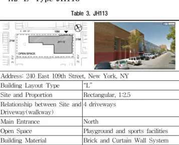
(6) 김필수․전유창. take one of the following shapes: “ㅡ”, “L”, “ㄷ”, “ㅁ”, “H”,. 4.2 “L” Type JH113. or “T”. Those whose shape does not fall under one of. Table 3. JH113. these categories are considered to have an “irregular” shape. This study analyzes key examples of each layout type in terms of site proportion / relationship between site and driveway, main entrance location, and characteristics of open space.. Address: 240 East 109th Street, New York, NY. 4.1 “ㅡ” Type PS194 Table 2. PS194. Building Layout Type. “L”. Site and Proportion. Rectangular, 1:2.5. Relationship between Site and 4 driveways Driveway(walkway) Main Entrance. North. Open Space. Playground and sports facilities. Building Material. Brick and Curtain Wall System. The site of this layout type takes up an entire block, Address: 244 WEST 144 STREET MANHATTAN, NY. opening up all four sides of the site to the streets and. Building Layout Type. “ㅡ”. Site and Proportion. Rectangular, 1:2. allowing the school to become a community center for the. Relationship between Site and 2 driveways Driveway(walkway) Main Entrance. North. Open Space. Playground and sports facilities. Building Material. Stone Base/Brick/Punched Window. eight adjacent blocks(including diagonally adjacent). The northern and eastern faces follow the surrounding context. The main entrance faces north to ensure the safety of students and staff members commuting via personal vehicles or school bus. The L-shaped building hugs the. The site is located between the north and south blocks,. northeastern corner of the block, providing maximal. and between clusters of buildings to the east and west.. sunlight and ventilation to the building while creating the. The “ㅡ” shaped building has its main entrance to the. ideal outdoor space. The outdoor space has three open. north, thereby maintaining frontality. The materials and. sides, making it highly accessible to the community. In. surface pattern of the northern face of the building have. particular, by opening up an entire side to the avenue, the. been selected in consideration of the surrounding context.. outdoor space becomes strongly cohesive with the. Meanwhile, the southern side of the building provides a. community as the avenue forms an axis connecting the. bright and open outdoor space for the students and the. northern and southern communities. The heavy traffic in. community. The L-shaped outdoor space is maximally. the avenue and the visual openness of the space make the. exposed southward, providing an ideal recreational space. school’s outdoor space highly approachable. The avenue. while providing maximum lighting to the south-facing. side of the outdoor space hosts athletic and recreational. classrooms. In addition, the L-shaped outdoor space. structures for the community, while the more central. visually connects the north and the south while providing. portion of the outdoor space is designated for school. recreational / athletic facilities to connect the communities. usage.. to the north and south of the school. In effect, this type of. efficiently and effectively leverages the traits of the grid. outdoor space unites the communities of three blocks into. system, making it the most popular building type among. a single unit. The “ㅡ” type layout creates relatively. Manhattan public schools.. spacious and efficient outdoor space amidst the crowded blocks of Manhattan, providing open space for the community.. 8 한국교육시설학회논문집 제20권 제2호 통권 제93호 2013년 3월. The. “L”. shaped. entire-block configuration.
(7) 뉴욕시 공립학교에 나타난 배치 특성에 관한 연구. 4.3 “ㄷ” Type PS173. Table 5. MS247. Table 4. PS173. Address: 32 West 92nd Street, New York, NY Address: 306 Fort Washington Avenue, New York, NY Building Layout Type. “ㄷ”. Site and Proportion. Irregular. Relationship between Site and 3 driveways Driveway(walkway) Main Entrance. West. Open Space. Playground and sports facilities. Building Material. Stone Base/Brick/Punched Window. Building Layout Type. “ㅁ”. Site and Proportion. Rectangular, 1:2. Relationship between Site and 2 driveways Driveway(walkway) Main Entrance. North. Open Space. Playground and sports facilities. Building Material. Brick/Punched Window. the bus. Unlike PS194, this site is very confined. Thus, the. The building is adjacent to the streets on three sides,. “ㅁ” configuration has been selected to accommodate the. which facilitates cohesion with surrounding blocks, but. building on a confined site. While the hollow box shape. does not provide enough square area to independently. provides the benefit of unbroken circulation and an inner. accommodate all of the programs and outdoor space. courtyard, the limited block size makes it difficult to create. needed by the school. In addition, as the site does not fully. an outdoor space suitable for recreation, and the space. cover the northern street, the main entrance is placed. may even feel congested. Furthermore, this configuration. instead on the western side adjacent to the avenue.. suffers from poor lighting and ventilation and is. One advantage of the irregular geometry of the site and. susceptible to external noise. However, a portion of the. the “ㄷ” shape of the building is that a buffer zone is. site is apportioned outside the box-shaped building so as. naturally created to filter out streetside noise. While the. to visually and spatially connect the northern and southern. open box shape strives to provide maximal lighting,. blocks. This outdoor space contains athletic and recrea-. ventilation, and circulation, the limited square area of the. tional facilities that help integrate the three community. site leads to substantial differences in the lighting and. blocks.. ventilation among classrooms. The “T” shaped outdoor space displaced by the “ㄷ” shaped building can be small. 4.5 “H” Type PS11 Table 6. PS11. and isolated, potentially resulting in security issues. However, this school’s outdoor space is opened to the north and the south, creating a visual connection that resolves such safety concerns. The “ㄷ” type layout is the third most common type among Manhattan school buildings, selected for its flexibility in confined or irregular. Address: 320 West 21st Street, New York, NY. sites.. Building Layout Type. “H”. Site and Proportion. Irregular. 4.4 “ㅁ” Type MS247. Relationship between Site and 2 driveways Driveway(walkway). The building site is bordered to the north and the south. Main Entrance. by streets, and to the east and the west by building clusters. The main entrance to the northern street. North. Open Space. Playground and sports facilities. Building Material. Stone Base/Brick/Punched Window. maintains frontality and the light traffic of the northern. The available space for this school is irregularly shaped. street maximizes the safety of students getting on and off. like an “L”, and located between crowded residential 한국교육시설학회논문집 제20권 제2호 통권 제93호 2013년 3월 9.
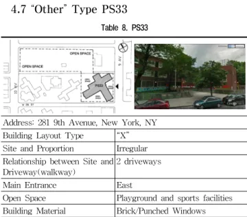
(8) 김필수․전유창. clusters. The building itself is shaped like an “H”, a. enhances the outdoor spaces, making the site valuable as. common configuration for schools built in the late 18th. a significant community recreation space.. century or the early 19th century. The “H” configuration is a historical school building layout from the early New. 4.7 “Other” Type PS33. York era. Frontality is established by placing the main. Table 8. PS33. entrance on the northern street where traffic is light. The two side wings blend well with the contextual masses, while opening up a central outdoor space to ensure circulation, lighting, and ventilation. The smaller courtyard to the north also provides sufficient space to facilitate the busy traffic of commuting students and staff, while the southern courtyard is left more spacious to maximize lighting and ventilation. However, the northern courtyard is the only outdoor space connected beyond the campus, limiting the school’s exposure to the surrounding blocks and the school’s role in the community. 4.6 “T” Type PS30. Address: 281 9th Avenue, New York, NY Building Layout Type. “X”. Site and Proportion. Irregular. Relationship between Site and 2 driveways Driveway(walkway) Main Entrance. East. Open Space. Playground and sports facilities. Building Material. Brick/Punched Windows. The site is shaped like a “Z”, which is an irregular. Table 7. PS30. shape for a school site. The school facilities are interspersed around the apartment buildings on the block. PS33 is unlike other school sites in that, instead of adapting to the grid system, the building takes after the “X” shape of the adjacent apartment buildings. The “X”. Address: 144-176 East 128th Street, New York, NY. shape allows for balanced lighting and ventilation of the. Building Layout Type. “T”. building and creates four triangular outdoor spaces. Site and Proportion. Rectangular, 1:2.5. between the building and the block perimeter. Frontality is. Relationship between Site and 4 driveways Driveway(walkway). westward, with the main entrance placed near the western. Main Entrance. North. avenue which allows for large volumes of traffic. The. Open Space. Playground and sports facilities. Building Material. Brick/Punched Windows. large open space in the northwest corner helps alleviate congestion during commuting hours. Athletic and recrea-. PS30 uses an entire block as its site. As all four sides. tional facilities are placed across the street from the. of the site are exposed to the streets, the site serves as a. northern block, providing an open space and a place of rest. community center for the eight surrounding blocks. This. for the students and the community. The connection to the. is the optimal school building configuration for the. high-traffic avenue also helps vitalize the site as a social. Manhattan grid system. Exposure to both avenues ensures. venue.. sufficient pedestrian traffic for the school to be an important community space. The large school building is. 5. Analysis of Building Layouts and Streets. shaped like a “T”, with its main entrance to the north for frontality. Outdoor spaces are left in the southeastern and southwestern corners for maximum lighting and ventilation,. 5.1 Building Layouts of Community School Districts(CSD). while providing recreational or athletic facilities for the. Table 10 illustrates that the most common layout. community. Access to both bordering avenues greatly. plans in CSD 1 were, in order, type “L”, type “ㅁ”, and. 10 한국교육시설학회논문집 제20권 제2호 통권 제93호 2013년 3월.
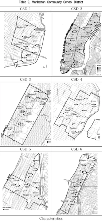
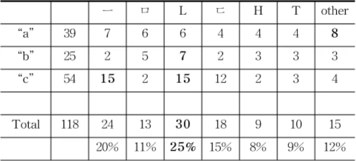
(9) 뉴욕시 공립학교에 나타난 배치 특성에 관한 연구 Table 9. Manhattan Community School District CSD 1. CSD 2. CSD 4 CSD 4 is located on the upper east side of Manhattan and serves the neighborhood of East Harlem. 12 of 18 researched schools in CSD 4 have an “a” block type and 6 of 18 researched schools have a “4” site type. CSD 5 CSD 5 is located in northern Manhattan. Neighborhoods within CSD 5 include Central Harlem and Manhattanville. 12 of 17 researched schools in CSD 5 have an “a” block type and 5 of 17 researched schools have a “4” site type. CSD 6 CSD 6 is located at the northern end of Manhattan. Neighborhoods within CSD 6 include Hamilton Heights, Sugar Hill, Washington Heights, Fort George and Inwood. 12 of 22 researched schools in CSD 6 have an “a” block and 10 of 22 researched schools have a “4” site type.. CSD 3. CSD 4. CSD 5. CSD 6. Table 10. Building Layout Type Distribution Chart by CSD ㅡ. ㅁ. L. ㄷ. H. T. other. CSD 1. 15. 2. 3. 4. 1. 1. 1. 3. CSD 2. 25. 5. 3. 11. 1. 2. 0. 3. CSD 3. 21. 2. 4. 6. 2. 2. 3. 2. CSD 4. 18. 5. 1. 3. 2. 3. 1. 3. CSD 5. 17. 7. 2. 2. 2. 0. 3. 1. CSD 6. 22. 3. 0. 4. 10. 1. 2. 2. Total. 118. 24. 13. 30. 18. 9. 10. 15. 20%. 11%. 25%. 15%. 8%. 9%. 12%. the irregular type. In CSD 2, “L” type was most common, followed by type “ㅡ”. In CSD 3, “L” type was most common, followed by “ㅁ” type. In CSD 4, “ㅡ” type was most common, followed by “L” type, “H” type, and the irregular type. In CSD 5, “ㅡ” type was most common, followed by “T” type. In CSD 6, “ㄷ” type was most common, followed by “L” type. Overall, the surveyed Manhattan school building layout types were found to be in the following decreasing order: “L” > “ㅡ” > “ㄷ” > “other” > “ㅁ” > “T” > “H”.. Characteristics CSD 1 is located near the southern end of Manhattan, along the East River. 10 of 15 researched schools in CSD 1 have an “a” block type and 5 of 15 researched schools have a “4” site type CSD 2, CSD 2 covers a large portion of Manhattan including the neighborhoods of the Upper East Side through the Financial District. 5 of 25 researched schools in CSD 2 have a “b” block type and 10 of 25 researched schools have a “4” site type. CSD 3 CSD 3 is located on the west side of Manhattan, between Central Park and the Hudson River. 19 of 21 researched schools in CSD 3 have a “b” block type and 2 of 21 researched schools have a “4” site type.. 5.2 Block Types and Building Layouts According to the above table, 33% of Manhattan’s public schools are situated in type “a” blocks, 21% in type “b” blocks, and 46% in type “c” blocks. As the longest rectangular block type, type “a” blocks most often had an irregular layout, followed by types “ㅡ”, “ㄴ”, and “ㅁ”. The smaller rectangular blocks most commonly had type “L”, followed by type “ㅁ”. The irregularly shaped type “c” block also tended to have more “L” and “ㅡ” types of building layout. 한국교육시설학회논문집 제20권 제2호 통권 제93호 2013년 3월 11.
(10) 김필수․전유창 Table 11. Manhattan Block Type Manhattan Block Type. Table 13. Site Type Site Type. Characteristics “a” block type is located between 1st AVE and 5th AVE of Manhattan. The area of an “a” block type is about 8,280 sqM-11,700 sqM and consists of 34-48 lots. Each lot is 8m by 30m. Most schools in “a” block type have an area of half or 2/3 of a whole block.. a. “b” block type is located between 5th AVE and 12th AVE of Manhattan. The area of “b” block is about 16,000 sqM-18,400 sqM. Each block has 66 to 76 lots. Most schools in “b” block type have 1/3, 1/2 or 2/3 of a whole block.. b. There is an irregular type “c” created by the tilted axis of roads such as Broadway or by the shape of nature(rocks, elevation differences or waterfront) .. c. Characteristics. 1. “1” site type is surrounded by 8 blocks(north and south streets and east and west avenues), which is ideal for orientation, daylight, ventilation, accessibility, and openness.. 2. “2” site type is surrounded by 5 blocks(north and south streets and east and west avenues). Most buildings with this layout type are located on the east or west side of the block. This block type is good for accessibility, daylight, ventilation and openness. 3. “3” site type is only open to south and north streets. Usually, the north street is good for a main entrance and the south is suitable for open space for daylight but noise and daylight for classrooms are constrained by the surrounding buildings.. 4. “4” site type has very limited access to daylight, accessibility, ventilation, and noise reduction.. Table 12. Building Layout Type Distribution Chart by Manhattan Block Type ㅡ. ㅁ. L. ㄷ. H. T. other. 7. 6. 6. 4. 4. 4. 8. “a”. 39. “b”. 25. 2. 5. 7. 2. 3. 3. 3. “c”. 54. 15. 2. 15. 12. 2. 3. 4. Total. 118. 24. 13. 30. 18. 9. 10. 15. 20%. 11%. 25%. 15%. 8%. 9%. 12%. 5.3 Site Types and Building Layouts According to the above table, of all public schools in Manhattan,. 19%. are. located. in. type. “1”. sites. surrounded by streets on all four sides, 30% in type “2” sites surrounded by streets on three sides, 34% in type “3” sites surrounded by two streets, and 16% in the irregular type “4” site. In type “1” sites, the most spacious type, irregular building layouts were found to be most common, followed by type “ㄷ”. In type “2” sites, “L” type buildings were most common, followed by type “ㄷ”. Type “3” sites also had “L” as the most common building layout, followed by type “ㅁ”. Type “4” sites also had “L” as the most common layout, followed by “ㅡ” and “other” types. 12 한국교육시설학회논문집 제20권 제2호 통권 제93호 2013년 3월. Table 14. Building Layout Type Distribution Chart by Site Type ㅡ. ㅁ. L. ㄷ. H. T. other. “1”. 23. 0. 4. 4. 5. 1. 3. 6. “2”. 35. 3. 3. 13. 10. 1. 1. 4. “3”. 40. 8. 10. 13. 6. 1. 0. 2. “4”. 19. 5. 1. 8. 0. 0. 0. 5. Total. 118. 16. 18. 38. 21. 3. 4. 17. 20%. 11%. 25%. 15%. 8%. 9%. 12%. 5.4 Outdoor Space and Building Layouts Due to the nature of Manhattan where buildings are placed very close to each other, outdoor space plays an important role in providing lighting, ventilation and space for recreation or athletics. Moreover, the type of outdoor space is determined by the combination of the site type and the block type. Site types 1 and 2 are surrounded by three or four roads, making it possible to provide outdoor space to neighboring blocks. On the other hand, the confined sites of type 3 and 4 lead to greater priority on the building layout, with the remaining space being used for outdoor activities..
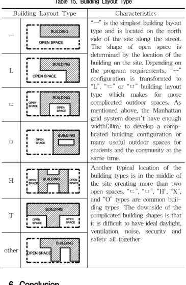
(11) 뉴욕시 공립학교에 나타난 배치 특성에 관한 연구 Table 15. Building Layout Type Building Layout Type. ㅡ. L. ㄷ. ㅁ. H. T. However, when the block is smaller or irregular, the size. Characteristics. of the site can also shrink or become irregular in shape.. “ㅡ” is the simplest building layout type and is located on the north side of the site along the street. The shape of open space is determined by the location of the building on the site. Depending on the program requirements, “ㅡ” configuration is transformed to “L”, “ㄷ” or “ㅁ” building layout type which makes for more complicated outdoor spaces. As mentioned above, the Manhattan grid system doesn't have enough width(30m) to develop a complicated building configuration or many useful outdoor spaces for students and the community at the same time.. In such conditions, the most simple types “ㅡ” and “L” can. Another typical location of the building types is in the middle of the site creating more than two open spaces. “ㄷ”, “ㅁ”, “H”, “X”, and “O” types are common building types. The downside of the complicated building shapes is that it is difficult to have ideal daylight, ventilation, noise, security and safety all together. other. provide the most reasonable and effective way to create outdoor space on a spatially limited site. If placed on a confined site, a “L” shaped building may be extended into “ㄷ” and “ㅁ” configurations. While the “L” type was most often found in the larger blocks, it can also be used flexibly on blocks of smaller shape. The “L” shape allows for optimal lighting, ventilation, and outdoor space even when the site is limited in size. Secondly, the building layouts of Manhattan’s public schools are affected by the type of site and the number of sides touching the street. The most ideal type of site is one that uses the entire block, becoming surrounded by streets on all sides. Such layouts allow for more freedom in determining open space, which readily interacts with the nearby streets for frontality. However, the buildings are generally placed northward to maximize the outdoor space, ventilation, and lighting afforded by the southern part of the site. Moreover, the street sides of rectangular blocks are often selected as the spots for the main. 6. Conclusion. entrance due to the safety and approachability afforded to commuters and school busses. On blocks surrounded by. There are seven building layout types of elementary and. streets on three sides, the “L” type was found to be most. junior high schools in Manhattan: “ㅡ”, “L”, “ㄷ”, “ㅁ”,. common, as it effectively filters out noise from. “H”, “T” and “other” type. Of these, “ㅡ” type and “L”. surrounding buildings while creating an appropriate. type occur most frequently, because these configurations. amount of outdoor space. The type 3 site also has its. most flexibly fit into the grid-locked blocks, the various. frontality and main entrance to the north. Type 3 sites and. types of topography, and adapt most dynamically to the. irregular blocks tend to be confined. When constructing. open spaces created by using avenues and streets. The. buildings in such small spaces, the configuration may. biggest factors that determine the types of building layout. change from “L”, to “ㄷ”, to “ㅁ”, if increase in the. are as follows.. demand for program necessitates building expansion.. First, the shape and size of blocks can influence the. Although more complicated configurations may finally. building layout type. The larger the block, the more ideally. provide the layouts needed, they also face greater. rectangular the site becomes, allowing more freedom in. disadvantages with regard to lighting, ventilation, and. deciding the placement of buildings or open spaces. As the. placement of the open space, which are regarded to be less. above table illustrates, “L” type is the most ideal layout,. important than securing all the indoor space the school. because it keeps the outdoor space contiguous, large, and. needs for its programs.. connected to the street. Furthermore, if the site is wide. Lastly, building layout type also influences the size and. enough, many variations of layouts can be attempted.. shape of the outdoor space. The more complicated the 한국교육시설학회논문집 제20권 제2호 통권 제93호 2013년 3월 13.
(12) 김필수․전유창. perimeter of the building and the more central the location of the building are, the more outdoor space is created. Although buildings on sites that use entire blocks may obstruct the appropriate outdoor space, it is far less economic for smaller sites to create complicated configurations which may only result in shadowy, hidden. 8. You-Jin Kim, “A Study on Revitalization of Elementary School Exterior Space to the Street.” 9. New York City Public Schools Demographic and Enrollment Trends, 1990-2002(Manhattan) 10. http://en.wikipedia.org/wiki/Commissioners'_Plan_of_1811 11. http://schools.nyc.gov/Offices/SCA/AboutUs/default.htm. pockets of campus ground that can lead to security issues. This study surveyed, analyzed, and outlined the characteristics of school building layout types of Manhattan’s public schools. Although the study may provide a point of reference when planning school layouts conjoined with adjacent streets, one should remember that the cases referred to come from New York City, which has many different factors from Korean cities. Further study is warranted for the street-conjoined school layouts in the Korean context. Bibliography 1. Eric Homberger and Alice Hudson , The Historical Atlas of New York City: A Visual Celebration of 400 Years of New York City's History, Holt Paperbacks, 2005 2. Eric W. Sanderson and Markery Boyer, Manhattan: A Natural History of New York City, Abrams, 2009 3. Hilary Ballon, The Greatest Grid: The Master Plan of Manhattan, 1811-2011 ,Columbia University Press, 2012 4. Peter C. Lippman, Evidence-Based Design of Elementary and Secondary Schools: A Responsive Approach to Creating Learning Environments, Wiley, 2010 5. Kim, Mi-Hyung Lee, Eul-Kyu Kim, Jun-Kyung, A Study on Layout Types of High Schools -Focused on High Schools Which Were Built from 2000 to 2004 in Gyeonggi Province, The Journal of Korean Institute of Educational Facilities v.12, n.4, July, 2005 6. Kim, Seung-Je, A Study of Exterior Space by Promotion Type in Elementary Schools, The Journal of Korean Institute of Educational Facilities v.16, n.6, Nov, 2009 7. Yang, Kum-Suek, A Study on the Layout and External Space of High School in Gyeongnam Area, The Journal of Korean Institute of Rural Architecture v.10, n.3, Aug, 2003. 14 한국교육시설학회논문집 제20권 제2호 통권 제93호 2013년 3월. 접수 2012. 12. 17 1차 심사완료 2013. 2. 3 게재확정 2013. 3. 8.
(13)
수치
+6

관련 문서
The purpose of this study was to analyze the relations between the leader-member exchange relationship, job satisfaction, and organizational citizenship behavior of sports
The purpose of this study is to examine the service quality of a tennis court which is one of public sport facilities and analyze a difference in
The purpose of this study is to verify whether The mediating effects of planned happenstance skills on the relationship between perceived social support
The purpose of this study is to analyze the influence of dance leaders' inst ructional behavior patterns on participants' desire to participate and
The purpose of this study is to analyze the interest and self-confidence of middle school students in learning English grammar and to examine the
The purpose of this study is to analyze the relationship between dance performances, which is a part of social contribution activities of local governments,
Purpose: The aim of this study is to identify the relationship between knowledge and awareness of radiation department students and their intent in
The purpose of this study is to examine the relationship among marketing mix factors, motivation for watching, relationship quality, and consumption
