Application of Multi-Class AdaBoost Algorithm to Terrain Classification of Satellite Images
Ngoc-Hoa Nguyen* , Dong-Min Woo*★
Abstract
Terrain classification is still a challenging issue in image processing, especially with high resolution satellite images. The well-known obstacles include low accuracy in the detection of targets, especially for the case of man-made structures, such as buildings and roads. In this paper, we present an efficient approach to classify and detect building footprints, foliage, grass and road from high resolution grayscale satellite images. Our contribution is to build a strong classifier using AdaBoost based on a combination of co-occurrence and Haar-like features.
We expect that the inclusion of Harr-like feature improves the classification performance of the man-made structures, since Haar-like feature is extracted from corner features and rectangle features. Also, the AdaBoost algorithm selects only critical features and generates an extremely efficient classifier. Experimental result indicates that the classification accuracy of AdaBoost classifier is much higher than that of the conventional classifier using back propagation algorithm. Also, the inclusion of Harr-like feature significantly improves the classification accuracy. The accuracy of the proposed method is 98.4% for the target detection and 92.8% for the classification on high resolution satellite images.
Key words: Texture Feature, Co-occurrence, Haar-like, AdaBoost, Terrain Classification
* Dept. of Electronics Eng., Myongji University [email protected] 031-330-6752
★Corresponding author
※ Acknowledgment: This research was supported by Basic Science Research Program through the National Research Foundation of Korea(NRF) funded by the Ministry of Education (No.
NRF-2012R1A1A2004950).
Manuscript received Oct. 15, 2014; revised Nov. 26, ,2014 ; accepted Dec. 3. 2014
I. Introduction
With the development of remote sensing technologies, automatic object classification from satellite images has become an essential component of many applications. Automatic object extraction is primarily needed in Geographic Information System (GIS) applications, since manual data acquisition for updating the GIS database is costly and time consuming task. GIS applications are widely used in many fields such as the defense industry,
transportation systems, emergency management, urban planning, navigation applications, etc. In response to the development trends in the field of satellite image processing, numerous approaches have been proposed to address issues related to accuracy, computation time. However, an optimal algorithm for image processing in general and terrain classification in particular has yet to be proposed. Instead, the choice of algorithm depends on the type of image, what the user is seeking, and the required accuracy. This topic thus warrants further study, and a new combination of feature extraction techniques should be considered.
This paper presents a terrain classification approach based on AdaBoost algorithm and the combination of feature extraction to detect multiple objects which include building, foliage, grass and road. Although these objects have some distinguished characteristics such as shape, texture, and color features, the classification task is still difficult due to the complexity and quantity of the
image. The image has a wide scope of building sizes, road sizes, this is non-homogeneous problem.
The color feature is very useful to distinguish between objects of terrain. But we use a grayscale satellite image, the color feature is omitted.
Knowing the above limitations, we seek to design an efficient algorithm which satisfies the criteria such as high accuracy, low computation time, multi-classification, and work well with complex data.
We describe a method to extract relevant features from the satellite image so that the AdaBoost algorithm can successfully train on a small data set, and classify a larger image. This work utilizes co-occurrence matrix, elevation data to extract 2D and 3D co-occurrence features [1]. Haar-like features are extracted from grayscale image [2, 3].
We then use these features to make a descriptor features training set. A multi-class AdaBoost is built based on the idea of Freund and Schapire [4]
to classify and detect. The reason why we choose AdaBoost and the above feature extraction is discussed in section 3.
The remainder of the paper is organized as follows. Section 2 surveys briefly the related work in the area of terrain classification. Section 3 outlines an overview of our approach. Section 4 presents our results. Lastly, section 5 gives a summary and our future work.
II. Related Work
There has been a tremendous increase in demand for applications to monitor objects related to remote sensing areas. For decades, many approaches have been proposed and achieved notable successes in solving terrain classification.
Advances in the field of remote sensing have promoted robust investment in research in this area.
Haralick has studied in this area by using a new type of texure feature. He proposed an image classification approach using co-occurrence features for descriptor vector of samples, and two classification algorithms (Piecewise Linear and min-max decision rule) [1]. Additionally, Haralick introduced 28 textural features which can be
extracted from co-occurrence matrix, and is used so far. Two types of feature extraction (decision boundary feature, and discriminant analysis feature) are carried out to classify remote sensing data from urban areas. [5] A comparison of classifiable perfomance was also done between co-occurrence features, Gabor filters, and MRFs. The comparison analysis shows that the co-occurrence features achived the highest classification rate. [6]
3D co-occurrence features [7] are proposed for the use of terrain classification. Neural Networks are employed to classify multiple objects like grass, road, shadows, and foliage. From the experiments, the 3D co-occurrence feature was evaluated well, and it can effectively reflect physical characteristics of the surface. Another approach was introduced to classify vegetation areas from high resolution images in urban areas [8]. This approach uses a linear-kernel SVM with a four dimensional radiometric feature vector to identify vegetation areas.
In recent years, the aspects of terrain classification are still interested, and Zhang [9] presents a terrain classification approach based on classification ontology to deal with complex multi-class. Neural network approach for terrain identification was proposed and experimented by Abou-Nasr [10]. This approach is a binary classifier using Recurrent Neural Networks, which is one of the most conventional classifiers for terrain classification.
III. Proposed Approach
3.1 Overall System Structure
The goal of the approach is to find a new solution to improve the accuracy and reduce the computation time of the terrain classification process in the high-resolution satellite images. To address the objective of this research, we focus on two major parts of the image classification issue: feature extraction, and learning algorithm.
In the feature extraction part, co-occurrence features are reported to work well for the natural terrain. [6] But if the man-made structures are included in the image, the classification difficulties increase. To alleviate the difficulties, in this paper,
we need to employ one more feature. Through the prior experiment, we adopted Haar-like feature for the following reason: Haar-like feature includes corner features and rectangle features, and this feature can be utilized to generate a building descriptor. We expect that the inclusion of Haar-like feature improves the classification performance from the image with the man-made structures. In this context, the proposed approach employs both co-occurrence feature and Harr-like feature in order to classify man-made structure as well as natural terrain.
In the learning algorithm part, we employ an AdaBoost algorithm for the classification. The AdaBoost learning algorithm is a supervised learning classifier which is simple and easy to program, and has no parameter to tune, since no prior knowledge is needed for weak learner. To verify the effectiveness of the employed AdaBoost classifier, we implemented neural network classifier using back-propagation algorithm, which is one of the most conventional classifier, and analyze the classification accuracies of both classifiers.
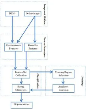
Fig. 1. Overall classification flow
Fig. 1 shows overall system flow for terrain classification. DEM and ortho-image are generated
from a pair of satellite images. 2D and 3D co-occurrence features and Harr-like feature are extracted from DEM and ortho-images, and for the selected regions of all the classes, training is carried out. In terms of AdaBoost learning process, the strong classifier is built. The final segmentation result is generated by the on-line classification process.
3.2 Co-occurrence Feature
Co-occurrence is a statistical method that has been widely used in remote sensing applications. Because it is a powerful feature extraction method in texture analysis, it has been applied extensively in land use classification. The co-occurrence feature is used to evaluate the spatial dependency in terms of a co-occurrence matrix, in which each element represents the number of occurrences. Once more, we use co-occurrence features to solve our problem with a combination of two dimensional and three dimensional domains with the aim of generating a composite texture. The co-occurrence matrix P can be defined as:
if ∧ ∆ ∆ (1)
In the method developed by Haralick [1], twenty-eight textural features are suggested. These features are computed for each of the four directions: 0, 45, 90, and 135 degree [7]. The distance parameter can be selected as one or higher. In this paper, we use a unit distance, four directions, and three textural features: Angular Second Moment (ASM), Contrast (CON), and Entropy (ENT) that are introduced to generate co-occurrence features. Among these, ASM is used to measure the uniformity of the data and can be defined as:
(2) CON provides evidence of how sharp the structural variations in the image are, and is given by
(3)
ENT provides a measure of the complexity and is computed by an entropy equation, written as
log (4)The different between 2D and 3D co-occurrence feature is the input to calculate the co-occurrence matrix from. If the input image is grayscale image, the calculated features are 2D. If the input image is digital elevation modal (DEM), the calculated features are 3D co-occurrence features [7]. In this paper, we extract 12 2D co-occurrence features and 12 3D co-occurrence features.
3.3 Haar-like feature
Haar-like features are digital image features used in object recognition, especially in real-time applications. A Haar-like feature considers adjacent rectangular regions at a specific location in a detection window, sums up the pixel intensities in each region, and calculates the difference between the sum of dark regions and the sum of bright regions. This difference is then used to categorize subsections of an image. The value of a Haar-like feature is calculated by the following equation:
(5) where N and M respectively are the number of dark and bright regions. P and Q are subsections of the image.
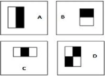
The feature A and feature B in Fig. 2 are designed to calculate the Haar-like’s value based on two subsections (rectangles). In features C and D, the value of the Haar-like feature is computed based on the sum of dark rectangles subtracted from the sum of bright rectangles. In order to improve the accuracy of the object detection rate,
Fig. 2. Basic Haar-like feature
an extended Haar-like method was introduced to increase the number of features [3]. In this paper, we use 21 Haar-like features.
3.4 AdaBoost Algorithm
In its original form, the AdaBoost learning algorithm [4] is used to boost the classification performance of a simple learning algorithm. It combines a set of weak classification functions to form a stronger classifier. Each weak learner determines the optimal threshold classification function, such that a minimum number of samples are misclassified. A weak classifier thus consists of a feature , a threshold , and a polarity indicating the direction of the inequality:
i f × × (6)
In this training process, the error rate of the current weak classifier is reduced based on updating of the previous classifier. The weights of the training set determine the probability of being selected for a feature and they are continuously updated via every weak classifier.
A multi-class problem is a more practical case than binary classification. As we mentioned before, the purpose of this paper is to distinguish between building, foliage, grass, and road. As shown in Fig.
3, our solution is similar to “One vs. All”
classification [12].
Fig. 3. Multi-class AdaBoost classification.
3.5 Back propagation Algorithm
The most conventional method for terrain classification is by way of neural networks using back propagation (BP) algorithm. BP algorithm addresses the nonlinear problems by using the least mean square algorithm. As shown in Fig. 4, a pattern is put to the input layer of network. The
data are converted via the weight factor and transferred to output layer. The difference between the result of the output layer and expected value is calculated according to the delta rule [11], and the weight factor is adjusted to reduce the difference.
A typical BP neural network is quite simple. It starts as a network of nodes arranged in three layers (input, hidden, and output layers). There is no theoretical on a standard network model as well as an optimal network model. Depending on a specific problem, we can find out a best network model from experiment. In this paper, the implemented back propagation network consists of an input of 45 neurons (45 nodes), one hidden layer of 25 neurons, and an output layer of 4 neurons used to recognize 4 classes.
Fig. 4. The structure of BP neural network
IV. Experimental Results
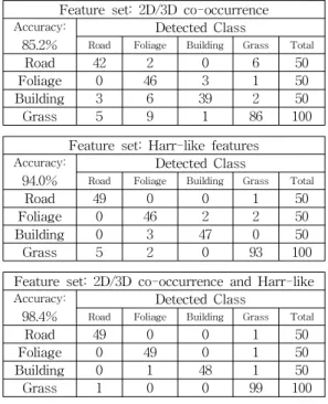
Ortho-image and DEM data are generated by a pair of high resolution IKONOS satellite images of Daejun area, specified in Table 1. A dataset is manually collected from ortho-image and DEM by 100 samples (32x32) for training, and other 250 samples (32x32) for this experiment. 24 co-occurrence features and 21 Haar-like features extracted for all the pixels in the sample and the label of each sample is detected in terms of the classification results of pixels within a sample.
Table 2 shows detection results of 250 samples by using AdaBoost classifier. The accuracy is calculated by the total number of correctly detected samples divided by total samples. Table 2 indicates that the accuracy is significantly improved by the addition of Harr-like features. The results exactly
Table 1. Specifications of image and 3D data Data type resolution grey level pixel size
Satellite images
2048x2048 16bit 1m x 1m Ortho-image 1600x2000 16bit 1m x 1m
DEM 1600x2000 N/A 1m x 1m
reflect our expectation, when we include Harr-like features in the feature set. Fig. 5 shows how a binary training process of foliage class achieves higher accuracy with respect to the number of iteration. In this experiment, the binary training processing converges very fast to gain high accuracy.
Table 2. Detection accuracy of 250 samples by AdaBoost Feature set: 2D/3D co-occurrence
Accuracy:
85.2% Detected Class
Road Foliage Building Grass Total
Road 42 2 0 6 50
Foliage 0 46 3 1 50
Building 3 6 39 2 50
Grass 5 9 1 86 100
Feature set: Harr-like features Accuracy:
94.0% Detected Class
Road Foliage Building Grass Total
Road 49 0 0 1 50
Foliage 0 46 2 2 50
Building 0 3 47 0 50
Grass 5 2 0 93 100
Feature set: 2D/3D co-occurrence and Harr-like Accuracy:
98.4% Detected Class
Road Foliage Building Grass Total
Road 49 0 0 1 50
Foliage 0 49 0 1 50
Building 0 1 48 1 50
Grass 1 0 0 99 100
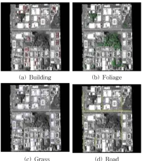
To evaluate the segmentation, we create the ground-truth image that correctly shows the label of its area. Since it is very difficult and inaccurate to make a ground truth image for entire area, we build many rectangles of area which clearly indicate the label of four classes, as shown in Fig. 6.
Consequently, each area is a rectangle with a class
Fig. 5. Performance of feature combination
label. We then compare the classified label of each pixel with the class label, and compute the accuracy of classification.
(a) Building (b) Foliage
(c) Grass (d) Road
Fig. 6. Ground truth images for 4 classes
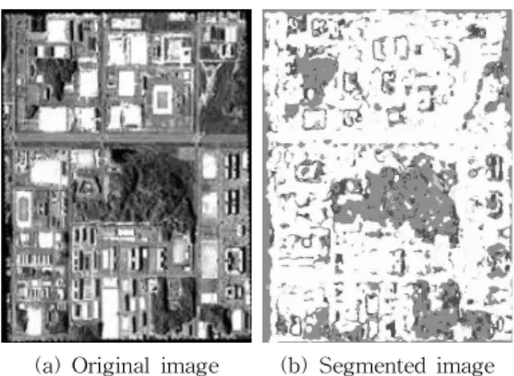
Fig. 7 shows the result of segmentation process, which classifies each pixel into one of 4 classes.
The 4 classes are indicated by 4 gray levels from black to white, which corresponds to building, foliage, grass and road, respectively. Table 3 shows the segmentation accuracy of each class. Even though we include Harr-like feature in the basic feature set, building area is shown to be still difficult to be correctly segmented. However, the
(a) Original image (b) Segmented image Fig. 7. Segmentation result using AdaBoost
Table 3. Segmentation accuracy using AdaBoost
Sample
Number of correct
pixels
Total number of
pixels
Accuracy
Building 40,373 59,619 67.7%
Foliage 67,304 75,052 89.7%
Grass 173,967 174,050 99.9%
Road 66,648 66,696 99.9%
Total 348,292 375,417 92.8%
overall accuracy turns out to be 92.8%.
To verify the effectiveness of the AdaBoost algorithm employed in this paper, we use the Back propagation (BP) algorithm for the classification comparison. The structure of BP neural network includes three layers (input layer-45 nodes, hidden layer-25 nodes, and output layer-4 nodes). For training the network, the weights of the nodes are randomized using random function ranging values from -1 to 1. For each training pattern, network layer weights are updated through each loop to reach its target. The network goes on training all the patterns repeatedly until the total error satisfies a threshold value. In this experiment, we use the same dataset, as we did with AdaBoost classifier.
Table 4. Detection accuracy of 250 samples by BP Feature set: 2D/3D co-occurrence and Harr-like Accuracy:
76.8% Detected Class
Road Foliage Building Grass Total
Road 16 1 2 32 50
Foliage 1 47 0 3 50
Building 1 2 30 17 50
Grass 0 1 0 99 100
Table 4 shows detection results of 250 samples by using BP (Back Propagation) classifier. Table 4 indicates that the accuracy is much low than that of AdaBoost classification. Fig. 8 shows the result of segmentation process by using back propagation.
The segmented result is not accurate, as shown in Fig. 8 (b). It seems that the back propagation algorithm is not suitable for the case, where the size of the feature set is very large. As for AdaBoost classifier, the critical features are selected, and the classification performance can be achieved.
In this case, we use 24 co-occurrence features and 21 Harr-like features along with the image intensity, AdaBoost classifier performs much better than the back propagation algorithm. Table 5 shows the segmentation accuracy of each class, when we use the BP classifier. The accuracy is worse than that of AdaBoost classification. In this context we conclude that AdaBoost classifier is very efficient in the application of terrain classification.
(a) Original image (b) Segmented image Fig. 8. Segmentation result using BP
Table 5. Segmentation accuracy using BP
Sample
Number of correct
pixels
Total number of
pixels
Accuracy Building 21,066 59,619 35.3%
Foliage 51,961 75,052 69.2%
Grass 20,377 174,050 11.7%
Road 65,850 66,696 98.7%
Total 159,254 375,417 42.4%
V. Conclusion
In this paper, we have presented a combined approach for the terrain classification of high resolution satellite images. Co-occurrence features are widely used for the classification of natural terrain. But if the man-made structures are included in the image, the classification difficulties increase.
To alleviate the difficulties, we adopted Haar-like feature combined with co-occurrence feature, since Haar-like feature includes corner features and rectangle features. Also, we employed an AdaBoost algorithm for the classification. The AdaBoost learning algorithm is a supervised learning classifier which is simple and easy to program, and has no parameter to tune, since no prior knowledge is needed for weak learner. According to the experimental results, the classification accuracy of our classifier is much higher than that of back propagation algorithm. Also, the combined use of Harr-like feature with co-occurrence feature considerably improves the classification performance.
In this respect, we can conclude that the proposed classification approach can be efficiently used in the terrain classification, especially for the satellite image with man-made structures.
References
[1] R. M. Haralick, K. Shanmugam and I. Dinstein,
“Textural features for image classification”, IEEE Trans. Systems, Man and Cybernetics, vol. SMC-3, no. 6, 610-621, 1973
[2] Paul Viola and Michael J. Jones, “Robust real-time face detection”, International Journal of Computer Vision, vol. 57, no. 2, 137-154, 2004 [3] David. A. Clausi and Haung Deng, “Design-based texture feature fusion using Gabor filters and co-occurrence probabilities”, IEEE Tran. Image Processing, vol. 14, no. 7, 925-936, 2005
[4] Y. Freund and R. E. Schapire, “A decision-theoretic generalization of on-line learning and an application to boosting”, Journal of Computer and System Sciences, vol. 55, issue 1, 119-139, 1997 [5] J. A. Benediktsson, M. Pesaresi, and K. Arnason,
“Classification and feature extraction for remote sensing images from urban areas based on
Dong-Min Woo (Member)
1980 : BS degree in Electronic Engineering, Yonsei University.
1982 : MS degree in Electronic Engineering, Yonsei University.
1987 : PhD degree in Electrical Engineering, Case Western Reserve University.
1990~ present : Professor, Myongji University morphological transformations”, IEEE Trans.
Geoscience and Remote Sensing, 1940-1949, 2003 [6] David. A. Clausi, “Comparison and fusion of co-occurrence, Gabor, and MRF texture features for classification of SAR sea-ice imagery”, Atmos.-Ocean. vol. 39, no. 3, 183-194, 2001
[7] Dong-Min Woo, Dong-Chul Park and Quoc-Dat Nguyen, “Terrain classification using 3D co-occurrence features and neural networks”, International Journal of Information Acquisition, vol. 4, no. 4, 1-9, 2007
[8] C. Iovan, D. Boldo, M. Cord, and M. Erikson,
“Automatic extraction and classification of vegetation areas from high resolution images in urban areas”, Springer, Lecture Notes in Computer Science, vol.
4522, 858-867, 2007
[9] Lei Zhang, Hai Wei, Jiejie Zhu, “An ontology-based multi-class terrain surface classification System For Aerial Imagery”, Proc.
IEEE ESPA, 95-95, 2012
[10] Abou-Nasr, “Terrain identification in grayscale images with recurrent neural networks”, Proc. IJCNN, 1-5, 2010
[11] Md. Ali Hossain, “Implementation of back-propagation neural network for isolated bangla speech recognition”, International Journal of Information Sciences and Techniques, vol. 3, no. 4, 1-9, 2013
[12] Ryan Rifkin and A. Klautau, “In defense of one-vs-all classification”, Journal of Machine Learning Research, vol. 5, 101-141, 2004
BIOGRAPHY
Ngoc-Hoa Nguyen (Student Member) 2011 : BE degree in Software Engineering, University of Science, Vietnam National University Ho Chi Minh City
2014 : MS degree in Electronics Engineering, Myongji University.
2014~ present : Software Engineer, R&D Center, iTank Com. Ltd. Korea