1. 서 론 (Introduction)
가뭄은 주기적으로 발생하는 기후의 한 특성으로 특 정기간 동안의 강수량 부족으로 인한 기상, 수문, 농업, 사회학적 물 부족 현상을 의미하며, 물의 수요와 공급간
의 상호작용에 기인한다(Wilhite et al., 2000;
Sivakumar et al., 2011a). 가뭄 분석은 시간적인 가뭄 의 발생과 공간적인 가뭄의 분포를 파악하는 것이 중요 하며, 효과적인 가뭄의 예측 및 대책을 위해서는 가뭄의 진행상황이나 강도를 정의할 수 있는 객관적인 기준을
기후변화대응을 위한 국립가뭄경감센터의 가뭄관리 및 정책방안
Drought Management and Policy based on Risk Assessment in the Context of Climate Change
남 원 호
School of Natural Resources, University of Nebraska-Lincoln/
Post Doctoral Research Associate [email protected]
Michael J. Hayes
National Drought Mitigation Center(NDMC), School of Natural Resources,
University of Nebraska-Lincoln/
Professor, Director [email protected]
Donald A. Wilhite
School of Natural Resources, University of Nebraska-Lincoln/
Professor [email protected]
Tsegaye Tadesse
National Drought Mitigation Center (NDMC), School of Natural Resources,
University of Nebraska-Lincoln/
Assistant Professor [email protected]
Mark D. Svoboda
National Drought Mitigation Center (NDMC), School of Natural Resources,
University of Nebraska-Lincoln/
Climatologist,
NDMC Program Area Leader [email protected]
Cody L. Knutson
National Drought Mitigation Center (NDMC), School of Natural Resources,
University of Nebraska-Lincoln/
Planning and Social Science Program Area Leader
이용해야 한다(Hayes et al., 2011a; Nam et al., 2012a). 국내의 가뭄평가에 관련된 연구는 외국에서 개 발된 가뭄지수의 적용성 판단에 집중되었으며 가뭄지수 를 이용하여 가뭄의 진행상황을 모니터링 함으로써 가 뭄을 평가하고 예측하기 위한 기법들이 개발되었다. 일 관된 가뭄의 정의 부재는 효과적인 가뭄관리 수행을 통 한 통합가뭄관리의 수행에 있어 어려움을 야기하고 있 으며, 하나의 가뭄지수로는 다양한 가뭄특성을 포괄하 여 제시하기 어려운 한계가 있다(Wilhite, 2011;
Botterill and Hayes, 2012). 따라서 물 관리 및 가뭄대 책 관리자는 해당 업무의 특성에 적합한 가뭄지수의 활 용하여 가뭄진행상황을 모니터링하고, 가뭄의 시공간적 인 전개과정을 조기에 확인하여 물 수요자와 공급자가 가뭄에 대비함으로써 가뭄피해를 최소화할 수 있는 예 방차원의 방안을 모색해야 한다(Hayes et al., 2004;
Knutson, 2013).
우리나라는 최근 전국적으로 심한 가뭄이 발생하여 사회적, 경제적, 환경적 피해가 대형화되어 가는 추세이 며, 이상기후현상의 증가 및 기후변화에 의해 가뭄에 대 한 취약성은 증가될 가능성이 있다(Kim et al, 2013;
Nam et al., 2014; Sohn et al., 2014). 현재의 가뭄관 리는 가뭄 발생 지역에 대한 단기대책으로서 임시 대체 용수의 개발, 확보 용수의 적정배분, 절수 유도를 통한 용수수요관리 등 사후대책에 국한되어 왔다. 또한 재해 예방 차원의 대처가 미흡하고, 가뭄상황을 파악할 수 있 는 객관적 지표가 명확하지 않으며, 가뭄모니터링과 예 경보기준이 미비하여 이에 대한 사전대비계획, 대응체 계 등 종합적인 대책이 부족한 실정이다(Bae te al., 2013). 우리나라의 경우 적어도 10년 이내에 한번 이상 발생하고 있는 가뭄에 대해 장기적이고 지속적인 모니
터링을 통하여 가뭄을 예보하고 가뭄의 심도를 파악하 여 대책을 수립해야한다. 물 관리에 있어 선진국으로 불 리는 미국, 호주, 영국 등의 경우, 가뭄심도의 정량적 평 가를 위한 모니터링 시스템이 구축되어 있고 가뭄의 진 행에 따른 단계별 대응체계가 수립되어 있으며, 정부기 관의 가뭄관련 정책을 수립하는데 중요한 도구로 활용 하고 있다(Wardlow et al., 2009; Hayes et al., 2011b;
McNutt et al., 2013). 본고에서는 최근 기후변화에 따 른 가뭄의 발생빈도 및 피해가 증가하는 상황에서 현재 구축되어 있는 미국의 가뭄재해 대응시스템의 현황을 파악하고, 이를 활용한 가뭄관리 및 가뭄대책, 정책 방 안에 대하여 살펴보고자 한다.
2. 기후변화에 따른 가뭄위험도 변화
(Change in drought risk and trend under climate change)
기후변화에 따른 가뭄위험도에 대한 연구의 경우, Princeton University의 Dr. Sheffield와 Dr. Wood 연구팀은 파머가뭄지수(Palmer Drought Severity Index, PDSI)을 사용하여 그림 1과 같이 전 세계의 가 뭄위험도를 산정하였다. 1950년부터 60년간 전 세계의 가뭄지수를 분석결과 1970년 이후 점진적으로 가뭄강 도가 심화되며, 유라시아, 아프리카, 캐나다, 알래스카 와 호주 동부 대부분의 지역에 걸쳐 가뭄지역이 증가하 는 것을 확인하였다(Palmer and Raisanen, 2002;
Battisti and Naylor, 2009; Sheffield et al., 2012;
Trenberth et al., 2014).
그림 2는 1895년부터 2013년의 기간 동안 미국에서 가뭄이 발생한 지역의 비율을 도시한 것(Heim, 2002;
Wilhite, 2009; Hayes et al., 2011a)으로 1930년대, 1950년대, 1960년대의 경우 가뭄 발생지역이 약 40%정 도에 도달한 것을 확인할 수 있다. 또한 1990년대 후반 에는 가뭄의 기간, 빈도가 증가하고 공간적 범위가 증가 하는 경향이 나타났다. 미국해양기상청(National
Oceanic and Atmospheric Administration, NOAA)이 발표하는 재해유형별 경제손실액 보고서(Smith and Katz, 2013)에 의하면 가뭄에 의한 경제적 손실은 홍수 에 비해 2배 이상이며, 1980년 이후 가뭄의 발생빈도는 전체 재해빈도 중 14%에 해당하지만 그 피해액은 전체 재해피해액 25%를 차지하고 있다(표 1).
이처럼 가뭄에 대한 위험도가 증가하고 있는 상황에 서 미국의 경우 1982년 콜로라도 주, 사우스다코타 주, 그림 1. Global average time series of the PDSI and area in drought, blue line is PDSI based on Thornthwaite
method and red line is PDSI based on Penman-Montheith method(Sheffield et al., 2012)
그림 2. Percent area of the United States in severe to extreme drought (Jan. 1895 ∼ Dec. 2013) based on
data from the National Climatic Data Center/NOAA (source: National Drought Mitigation Center,
University of Nebraska-Lincoln, USA)
Disaster Events (Number)
Damage (Billion dollar)
Damage/
Event
Hurricanes 29 375 12.9
Tornadoes 30 79 2.6
Droughts 16 195 12.2
Floods 14 74 5.3
Fires 11 20 1.8
Winter-related 13 43 3.3
표 1 Billion-dollar weather/climate disasters 1980- 2011 based on data from National Climatic Data Center (source: National Drought Mitigation Center, University of Nebraska-Lincoln, USA)
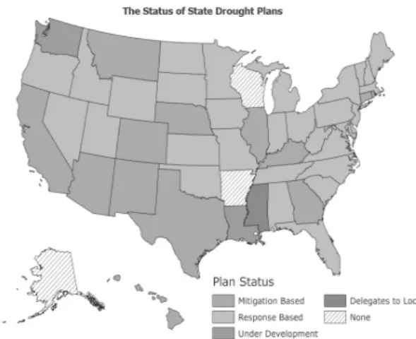
뉴욕 주를 시작으로 2013년 현재 46개 주에서 연방정부 단위의 가뭄 계획을 수립하였다(Wilhite, 2011). 그림 3 은 정부의 가뭄 계획 여부에 따라 가뭄 계획을 분류하여 도시한 것으로, 가뭄 계획의 경감 기반(Mitigation based) 정책 또는 대응 기반(Response based) 정책의 여부, 장기 가뭄 계획의 개발 여부 등을 나타내고 있다.
3. 미국의 가뭄재해대응시스템 구축현황 (National drought program based on risk assessment)
미국은 효율적인 가뭄관리를 위하여 1995년 Nebraska-Lincoln 대학교 자연과학대학(School of Natural Resources)에 국립가뭄경감센터(National Drought Mitigation Center, NDMC)를 설치하였다 (http://drought.unl.edu). NDMC는 미국의 전역에 대
한 종합적인 가뭄 모니터링, 가뭄 예보, 각 주별 가뭄관 리계획 및 가뭄경감계획의 수립, 가뭄 관련 정책자문, 가뭄 관련 교육프로그램의 운영, 가뭄 관련 교재 및 자 료의 출간업무를 수행하고 있다. 또한 NDMC의 가뭄모 니터링 사업은 NOAA, 미국 국가기후자료센터 (National Climatic Data Center, NCDC), 미국지질조 사국(United States Geological Survey, USGS) 등 여 러 연방기관들과 협조하여 진행하고 있으며, 일주일 단 위로 미국 전역의 가뭄진행상황 및 가뭄심도를 모니터 링하고 그 결과를 바탕으로 각 주에 대한 가뭄상황을 예 보하여 미국립기상청(National Weather Service, NWS), 미국농무부(United States Department of Agriculture, USDA)에 가뭄정보를 제공하고 있다.
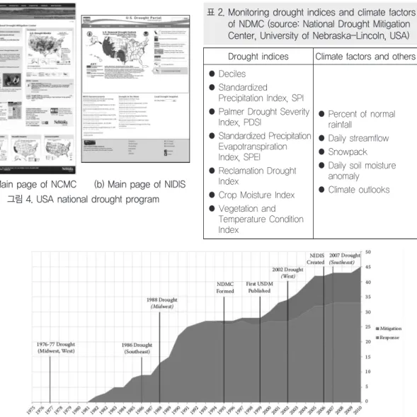
NDMC의 가뭄대응 및 관리 전략은 모니터링 (Monitoring) 및 조기경보(Early Warning), 계획 (Planning) 및 경감(Mitigation)의 세 가지 주요 구성 요소로 분류되며, 가뭄 및 물 공급 계획에 관련되어 있 는 주정부, 연방정부, 및 지역단체에 가뭄관련 업무 지 원 및 수자원공급계획의 수립을 지원하고 있다. NDMC 에서 제공하는 기상 요소 및 가뭄 모니터링 지표는 표 2 와 같다.
이후 NDMC와 NOAA가 개발에 참여하여 2006년 (Public Law 109-430) 국가통합가뭄정보시스템 (National Integrated Drought Information System, NIDIS)이 설립되었다(그림 5). NIDIS는 미국의 여러 기 관의 가뭄 자료를 제공받아 통합하고 실시간으로 미국 전역의 가뭄을 모니터링 함으로써 효과적인 가뭄 조기 경보시스템을 제공하고 있으며, 가뭄예측 및 주별 가뭄 관리, 경감계획 등에 관한 정보를 제공하고 있다 (http://www.drought.gov).
그림 3. The statues of state drought plans (updated 2013)
(source: National Drought Mitigation Center, University of Nebraska-Lincoln, USA)
4. 가뭄 모니터링 및 조기 경보를 활용한 의사 결정시스템
(Decision support system using drought monitoring and early warning)
NDMC의 가뭄 모니터링 시스템은 Drought Monitor(http://droughtmonitor.unl.edu) 사이트를 개설하여 미국 전역에 대한 종합적인 가뭄상황을 일주 일 간격으로 제시하고 있으며, 가뭄상태를 진단하는 각 종 가뭄지표들에 대한 현황과 예보치를 확인할 수 있도 (a) Main page of NCMC (b) Main page of NIDIS
그림 4. USA national drought program
표 2. Monitoring drought indices and climate factors of NDMC (source: National Drought Mitigation Center, University of Nebraska-Lincoln, USA) Drought indices Climate factors and others
● Deciles
● Standardized
Precipitation Index, SPI
● Palmer Drought Severity Index, PDSI
● Standardized Precipitation Evapotranspiration Index, SPEI
● Reclamation Drought Index
● Crop Moisture Index
● Vegetation and Temperature Condition Index
● Percent of normal rainfall
● Daily streamflow
● Snowpack
● Daily soil moisture anomaly
● Climate outlooks
그림 5. Time line associated with the number of drought plans within the United States(McNutt et al., 2013)
그림 6. U.S. drought monitoring system (source: http://www.drought.unl.edu) (a) Main page of U.S. drought monitor (b) Drought monitor weekly comparison
(c) Tabular data archive
(e) Spatial extent and severity of drought conditions in the United States, 2011 to 2014 (d) Drought monitor animations
록 구성되어 있다(Wilhite and Svoboda, 2000). 그 림 6(a)은 가뭄 상황을 종합적으로 보여주는 화면으로 서 2014년 4월 29일자 가뭄현황을 종합적으로 분석한 결과를 제시하고 있다. 또한 (b) 주별 가뭄상황 비교, (c) 테이블 형식의 가뭄기록, (d) 동적지도 형식 등 다 양한 형태로 가뭄정보를 제공한다. 가뭄 상황은 가뭄 의 강도에 따라 가뭄의 초기 상태인 D1에서부터 아주 극심한 상태인 D4까지 4단계로 구분하여 표시하고 있 다. D0는 가뭄주의지역(Drought watch area)으로서 건조가 시작되고 가뭄으로 발전할 가능성이 있거나, 또는 가뭄으로부터 회복중이나 아직 정상상태까지는 도달하지 못한 상태로서 저수지의 수위저하와 같은 장 기영향을 받는 지역이다. 그림 6(e)는 2011년부터 2014년까지 과거 가뭄기록에 대한 공간적인 분포를 나타낸 것이다.
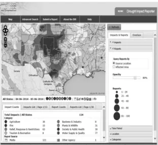
2005년부터 NDMC는 Drought Impact Reporter (http://droughtreporter.unl.edu) 사이트의 가뭄 리 포트를 통해 11,000개 이상의 가뭄상황 데이터베이스 를 구축하고 있으며, 미디어, 정부기관 등 미국의 다양 한 가뭄상황 정보를 체계적으로 수집하고 38개 주에 13,000명의 의사결정자 및 정책입안자, 미디어, 일반인 들에게 실시간으로 웹기반의 가뭄 정보를 제공하고 있 다. 그림 7은 2014년 4월 6일부터 5월 6일까지 텍사스 주의 가뭄 영향 리포트의 현황을 나타내며, 지정된 기 간에 대한 가뭄영향 보고서를 열람할 수 있다.
Vegetation Drought Response Index(VegDRI, http://vegdri.unl.edu)는 NDMC와 USGS에서 개발한 식생 가뭄모니터링 지표(Tadesse et al., 2005; Brown et al., 2008)로써, 2주 간격으로 위성영상을 활용한 식 생에 대한 가뭄상황을 제공하고 있다. 그림 8(a)는 NDMC의 VegDRI 모니터링 시스템으로 가뭄 지역의 통계 및 1989년 이후 25년간의 시계열 지도, 동적 지도 등을 제공하고 있으며, 그림 8(b)는 USGS의 VegDRI 모니터링 시스템으로 웹기반의 GIS 환경을 제공하고 있다. 또한 Vegetation Outlook(VegOut)을 통해서 현 재의 식생 상태를 기초로 토지피복, 관개상태, 토양 등 의 정보를 활용하여 미래의 식생 상태를 예측하는 연구 들이 진행되고 있다 (그림 8(c)).
NDMC의 Drought Risk Atlas(http:// droughtatlas.
unl.edu) 시스템은 기후학적 데이터를 비롯하여 Deciles, SPI, SPEI, PDSI의 가뭄지수의 과거 가뭄기 록, 가뭄경향, 가뭄심도, 가뭄기간 등과 함께 주단위로 미국전역의 가뭄위험도 지도를 제공한다(그림 9).
그림 7. An example of drought impact information in the drought impact reporter (DIR) for the state of
Texas from Apr. 2014, to May 2014
그림 8. Vegetation drought response index(VegDRI) monitoring system (source: National Drought Mitigation Center, University of Nebraska-Lincoln, USA)
(c) Vegetation outlook(VegOut) (a) Main page of vegetation drought response
index hosted by the NDMC
(b) Main page of vegetation drought response index hosted by the USGS
5. 가뭄 계획 및 경감
(Drought planning and mitigation)
NDMC는 농가 단계의 개인을 위한 가뭄 계획 프로세 스(Farm/Ranch-level Drought Planning)를 제공하 고 있다. 가뭄 준비 커뮤니티(Drought Ready Communities)는 가뭄 대비를 위한 준비과정으로 과거 가뭄 경감을 위한 사례 연구와 광범위한 자료를 수집하 여, 가뭄 발생 전의 대책 활동에 대한 정보를 제공하며 (그림 10), Drought Scape라는 분기별 뉴스레터를 발행한다(그림 11).
가뭄이 본격화되기 전에 대비계획과 가뭄의 진행에 따른 적절한 대응책을 수립하기 위해서는 가뭄심도의
조기 확인과 현재 가뭄상황에 대한 정확한 이해가 필요 하다. 가뭄 준비 커뮤니티는 총 5단계로 구성되며 (Knutson et al., 1998; Wilhite and Svoboda, 2000;
Knutson and Haigh, 2013), 1단계에서는 가뭄관련 정 보가 수자원 전문가와 물 공급 관리자로부터 일반 시민 등에 이르기까지 여러 분야의 가뭄 계획과 관련된 그룹 을 형성한다. 2단계는 과거 가뭄의 영향에 대한 정보를 수집하고 가뭄을 감소시킬 수 있는 대책의 우선순위를 할당하며, 3단계에서는 현재의 가뭄 상태를 평가하는 가뭄지표를 정의하고 실시간 모니터링 시스템을 구성한 다. 즉, 가뭄의 시, 공간적인 전개과정을 조기에 확인하 여 물 수요자와 공급자들이 가뭄에 대비함으로써 피해 경감을 최대한 유도한다. 4단계는 가뭄계획을 대중들에 그림 9. Drought risk atlas and drought monitor decision support system
(a) Main page of drought risk atlas (b) Drought risk atlas for the state of Texas from 2000 to 2014
게 공개하고 가뭄계획에 대한 인식 및 교육 자료를 위한 프로그램을 개발하며, 5단계는 이전 단계에서 개발된 정보를 통합하여 가뭄 발생 전에 수행되어야 할 전략과 가뭄 대비 행동의 목록을 작성하고 가뭄 계획을 수행할 시기를 결정한다.
6. 가뭄관리 및 정책방안
(Drought management and policy)
기후변화로 인한 전 세계적인 가뭄재해의 증가로 인 해 가뭄관리 및 경감에 대한 필요성이 대두되었으며, 국 가단위의 가뭄 정책의 수립 및 도입에 대한 요구가 지속 되었다. 세계기상기구(World Meteorological Organization, WMO)는 통합 가뭄관리 프로그램 (Integrated Drought Management Programme, IDMP)을 출범하였으며, 2013년 제네바에서 High- level Meeting on National Drought Policy(HMNDP) 이 개최되었다. 이 회의는 정부 단위에서 고려되는 주요 가뭄 문제를 해결하기 위해 국가가뭄정책의 수립 관한 고위급 회담으로, 효과적인 국가 가뭄 정책의 주요 요소 그림 10. Farm/ranch-level drought planning and drought ready communities
(source: National Drought Mitigation Center, University of Nebraska-Lincoln, USA)
그림 11. Drought scape of the NDMC’s quarterly newsletter
(source: National Drought Mitigation Center, University of Nebraska-Lincoln, USA)
(a) Drought scape in Spring 2012
(b) Drought scape in Fall 2013
로써 사전 경감 및 계획, 위험관리, 가뭄 대비 계획에 대 한 국가단위의 네트워크 구성 및 협력 방안에 대해서 논 의되었다. Dr. Wilhite 교수와 Dr. Hayes 교수는 HMNDP에서 NDMC의 가뭄관리 및 가뭄계획, 정책방 안에 대한 주요 쟁점을 발표하였다.
Dr. Wilhite 교수는 1990년 가뭄관리를 위한 10단계 가뭄계획과정을 제안하였다(그림 12). 이 계획과정이 제 안된 초기에는 가뭄에 관련된 모니터링의 확대를 통해 가뭄 확산에 대한 적극적 경감 대책을 수립함으로써 가 뭄위기의 대응에 초점을 두었다(Botterill and Hayes, 2012). 가뭄계획과정은 1-4단계에서는 가뭄 특별대책 위원회를 구성하여 가뭄경감과 대응에 대한 권한을 부 여하고 가뭄계획에 대한 목표 및 정책방향에 대해 설정 을 한다. 또한 과거 가뭄의 영향 및 대응방안, 가뭄취약 지역, 가뭄에 가장 취약한 사회경제분야, 가뭄에 의한 장래 물 분쟁 및 취약성 변화가 예상되는 현재의 추세분 석, 계획과정을 추진하기 위한 재원 확보 등이 고려된 다. 5단계에서는 실질적인 가뭄계획을 개발하기 위한 위원회 구성 과정으로 모니터링 위원회(Monitoring committee), 위험평가위원회(Risk assessment committee), 경감 및 대응위원회(Mitigation and response committee)가 구성된다(그림 13). 6-7단계에 서는 과학자와 정책결정자간의 상호협력을 통한 가뭄관 리의 과학적/정책적 통합에 대한 내용을 포함되며, 8-9 단계는 가뭄계획에 대한 공개 및 교육프로그램 개발을 언급하고 있다. 계획과정의 마지막 단계에서는 가뭄계 획의 적절한 평가를 위한 세부항목들을 개발하고 가뭄 계획의 검토, 보완, 개선방안 및 효율성을 평가한다 (Sivakumar et al., 2011b; Wilhite et al., 2014).
그림 12. Ten-step planning process(Wilhite, 1990;
Wilhite et al., 2000)
그림 13. Organizational structure for drought management(Wilhite et al., 2000; 2014)
7. 결 론 (Conclusion)
미국의 국립가뭄경감센터의 운영은 가뭄 재해에 대비 하기 위한 비구조적인 방재시스템으로 종합적인 가뭄 모니터링, 가뭄 예보, 가뭄관리계획 및 가뭄경감계획의 수립, 정책자문 등을 제공하고 있다. 우리나라에서는 가 뭄이 발생할 때마다 사전대응보다는 가뭄이 진행된 후 긴급복구 대책에 의존하고 있으며, 다목적댐 건설, 대체 수자원의 개발 등의 구조적인 중장기 대책이 제시되고 있다. 이러한 구조적인 대책과 동시에 이상기후현상과 관련된 가뭄감시 모니터링 시스템 및 단기, 장기적인 가 뭄예보의 중요성이 요구된다. 따라서 지속적으로 반복
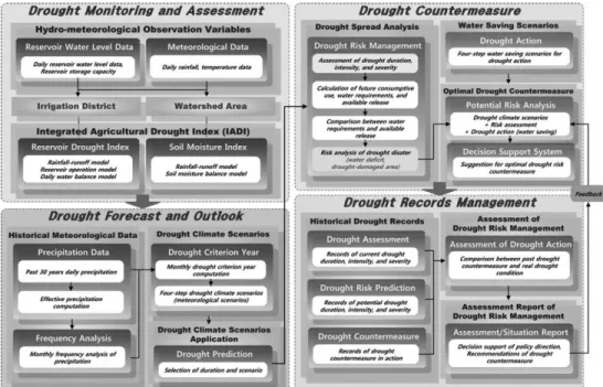
되는 가뭄이라는 자연재해에 대비하여 가뭄극복을 위한 체계적이고 조직적인 가뭄경감대책과 통합적인 가뭄관 리시스템의 개발이 요구된다(그림 14).
본고에서는 현재 구축되어 있는 미국의 가뭄재해대응 시스템의 현황과 기후변화 대응을 위한 국립가뭄경감센 터의 가뭄대책, 정책방안을 파악하였으며, 최근 발생하 는 기후변화에 따른 우리나라의 가뭄관리 및 가뭄대응방 안, 가뭄정책에도 적용될 수 있을 것으로 사료된다. 또한 각 기관별로 차별화된 다양한 가뭄지표 및 가뭄관리 특 성을 종합적으로 고려한 통합적 가뭄관리 시스템 개발을 통해 가뭄관련 의사결정자 뿐만 아니라 대중들에게 일반 화된 가뭄정보로 제공할 수 있을 것으로 기대된다.
그림 14. Decision support system process for agricultural drought management using risk assessment(Nam et al., 2012b)
감사의 글
본고를 위해 자료와 자문을 준 미국 국립가뭄경감센 터의 Dr. Hayes 소장과 Dr. Wilhite 교수, Dr.
Tadesse 교수, Dr. Knutson, Svoboda 연구원에게 감 사를 전합니다.
참고문헌
1. Bae, D.H., Son, K.H., Kim, H.A., 2013. Derivation &
evaluation of drought threshold level considering hydro-meteorological data on South Korea. Journal of Korea Water Resources Association 46(3): 287-299 (in Korean).
2. Battisti, D.S., Naylor, R.L., 2009. Historical warnings of future food insecurity with unprecedented seasonal heat. Science 323: 240-244.
3. Botterill, L.C., Hayes, M.J., 2012. Drought triggers and declarations: science and policy considerations for drought risk management. Natural Hazards 64: 139- 151.
4. Brown, J.F., Wardlow, B.D., Tadesse, T., Hayes, M.J., Reed, B.C., 2008. The vegetation drought response index (VegDRI): a new integrated approach for monitoring drought stress in vegetation. GIScience &
Remote Sensing 45(1): 16-46.
5. Hayes, M., Wilhelmi, O., Knutson, C., 2004. Reducing drought risk: bridging theory and practice. Natural Hazards Review 5(2): 106-113.
6. Hayes, M., Wilhite, D., Svoboda, M., Trnka, M., 2011a.
Handbook on climate change and agriculture, Ch. 5.
Investigating the connections between climate change, drought and agricultural production. ed. A.
Dinar, R. Mendelsohn, 73-86, Edward Elgar Publishing, Inc.
7. Hayes, M., Svoboda, M., Wall, N., Widhalm, M., 2011b.
The Lincoln declaration on drought indices: universal
meteorological drought index recommended. Bulletin of the American Meteorological Society 92(4): 485- 488.
8. Heim, R., 2002. A review of twentieth-century drought indices used in the United States. Bulletin of the American Meteorological Society, 1149-1165.
9. Kim, B.S., Sung, J.H., Lee, B.H., Kim, D.J., 2013.
Evaluation on the impact of extreme droughts in South Korea using the SPEI and RCP8.5 climate change scenario. Journal of the Korean Society of Hazard Mitigation 13(2): 97-109 (in Korean).
10. Knutson, C., Hayes, M., Phillips, T., 1998. How to reduce drought risk. Preparedness and Mitigation Working Group, Western Drought Coordination Council, University of Nebraska-Lincoln, Lincoln, NE.
11. Knutson, C., 2013. Water trading and global water scarcity: international experiences, Ch. 2. Managing water stress, drought and climate change in the twenty-first century: water trading as part of integrated approaches in water management. ed.
Josefina Maestu, RFF Press: New York, NY.
12. Knutson, C., Haigh, T., 2013. A drought-planning methodology for ranchers in the Great Plains.
Rangelands 35(1): 27-33.
13. McNutt, C.A., Hayes, M.J., Darby, L.S., Verdin, J.P., Pulwarty, R.S., 2013. Drought, risk management, and policy: decision-making under uncertainty, Ch. 10.
Developing early warning and drought risk reduction strategies. ed. L.C. Botterill, G. Cockfield, 151-170, Boca Raton, FL: CRC Press.
14. Nam, W.H., Choi, J.Y., Yoo, S.H., Engel, B.A., 2012a.
A real-time online drought broadcast system for monitoring soil moisture index. KSCE Journal of Civil Engineering 16(3): 357-365.
15. Nam, W.H., Choi, J.Y., Yoo, S.H., Jang, M.W., 2012b.
A decision support system for agricultural drought management using risk assessment. Paddy Water Environment 10: 197-207.
16. Nam, W.H., Hong, E.M., Choi, J.Y., 2014. Uncertainty
of water supply in agricultural reservoirs considering the climate change. Journal of the Korean Society of Agricultural Engineers 56(2): 11-23 (in Korean).
17. Palmer, T.N., Raisanen, J., 2002. Quantifying the risk of extreme seasonal precipitation events in a changing climate. Nature 415: 512-514.
18. Sheffield, J., Wood, E.F., Roderick, M.L., 2012. Little change in global drought over the past 60 years.
Nature 491: 435-437.
19. Sivakumar, M.V.K., Motha, R.P., Wilhite, D.A., Wood, D.A., 2011a. Agricultural drought indices. Proceedings of the WMO/UNISDR Expert Group Meeting on Agricultural Drought Indices, 2-4 June 2010, Murcia, Spain: Geneva, Switzerland: World Meteorological Organization. AGM-11; WAOB-2011. 182pp.
20. Sivakumar, M.V.K., Motha, R.P., Wilhite, D.A., Qu, J.J., 2011b. Towards a compendium on national drought policy. Proceedings of an Expert Meeting on the Preparation of a Compendium on National Drought Policy, 14-15 July 2011, Washington, D.C., USA:
Geneva, Switzerland: World Meteorological Organization. AGM-12; WAOB-2011. 135pp.
21. Smith, A.D., Katz, R.W., 2013. US billion-dollar weather and climate disasters: data sources, trends, accuracy and biases. Natural Hazards 67: 387-410.
22. Son, K.H., Bae, D.H., Ahn, J.H., 2014. Projection and analysis of drought according ro future cliamte and hydrological information in Korea. Journal of Korea Water Resources Association 47(1): 71-82 (in Korean).
23. Tadesse, T., Brown, J.F., Hayes, M.J., 2005. A new approach for predicting drought-related vegetation stress: integrating satellite, climate, and biophysical data over the U.S. central plains. ISPRS Journal of Photogrammetry & Remote Sensing 59: 244-253.
24. Trenberth, K.E., Dai, A., van der Schrier, G., Jones, P.D., Barichivich, J., Briffa, K.R., Sheffield, J., 2014.
Global warming and changes in drought. Nature Climate Change 4: 17-22.
25. Wardlow, B.D., Hayes, M.J., Svoboda, M.D., Tadesse, T., Smith, K.H., 2009. Sharpening the focus on drought: new monitoring and assessment tools at the National Drought Mitigation Center. Earthzine, unpaginated.
26. Wilhite, D.A., 1990. Planning for drought: a process for state government. IDIC Technical Report Series 90-1. International Drought Information Center, University of Nebraska-Lincoln, Lincoln, NE.
27. Wilhite, D.A., Hayes, M.J., Knutson, C., Smith, K.H., 2000. Planning for drought: moving from crisis to risk management. Journal of the American Water Resources Association 36(4): 697-710.
28. Wilhite, D.A., Svoboda, M., 2000. Drought early warning systems in the context of drought preparedness and mitigation. World Meteorological Organization, Geneva, Switzerland.
29. Wilhite, D.A., 2009. Coping with drought risk in agriculture and water supply system, Ch. 1. Drought monitoring as a component of drought preparedness planning. ed. A. Iglesias, L. Garrote, A. Cancelliere, F. Cubillo, D. Wilhite, 3-19, Springer, 1st Edition.
30. Wilhite, D.A., 2011. Breaking the hydro-illogical cycle:
progress or status quo for drought management in the United States. European Water 34: 5-18.
31. Wilhite, D.A., Sivakumar, M.V.K., Pulwarty, R., 2014.
Managing drought risk in a changing climate: the role of national drought policy. Weather and Climate Extremes (in press).