Vol. 18, No. 10 pp. 36-41, 2017
공간정보 구축 분야의 모바일 매핑 시스템 활용을 위한 상용 시스템의 특징 및 현황 조사
박준규1, 엄대용2*
1
서일대학교 토목공학과,
2한국교통대학교 토목공학과
Characteristics and Status of Commercial System for Utilizing MMS in Geospatial Information Construction
Joon-Kyu Park
1, Dae-Yong Um
2*1
Department of Civil Engineering, Seoil University
2
Department of Civil Engineering, Korea National University of Transportation
요 약 1991년 미국 오하이오 주립대학에서 처음 소개한 모바일 매핑 시스템은 센서기술이 발전함에 따라 다양한 형태로 개발되고 있다. 모바일 매핑 시스템은 이동체의 위치와 자세정보, 다양한 센서들의 취득 데이터를 통해 이동체 주변의 공간정 보를 빠르게 취득할 수 있는 시스템으로 기존의 GNSS나 토털스테이션과 같은 측량 방법보다 생산성을 극대화 시키고 있다.
현재 해외 기업을 중심으로 다양한 시스템이 출시되고, 공간정보 구축분야에 적용이 활발하게 이루어지고 있지만 국내에서 의 관련 기술개발이나 실질적 활용은 아직 부족한 실정이다. 본 연구에서는 지상기반 모바일 매핑 시스템을 중심으로 상용화 된 시스템의 현황 조사 및 특징 분석을 수행하여 공간정보 관련 업무에 시스템 도입을 위한 기초자료를 제공하고자 하였다.
연구를 통해 다양한 형태의 모바일 매핑 시스템의 현황 및 특징을 파악하였으며, 최근 시스템 개발 동향이 도입단가를 낮추 기 위한 방향으로 진행되고 있음을 제시하였다. 현재 자동 정합 등 자료처리 기술의 발달, 저가형 모델 출시 등 공간정보 구축 분야의 모바일 매핑 시스템 적용을 위한 기반이 조성되고 있어 향후 관련분야의 도입 활성화와 작업 효율성 향상이 기대된다.
Abstract The mobile mapping system first introduced at Ohio State University in 1991 is being developed in various forms as sensor technology develops. The mobile mapping system can acquire geospatial information around amoving object quickly using the information gathered using the position and attitude information of the moving object and thedata fromvarious sensors. The mobile mapping system can rapidly acquire large amounts of Geospatial information and MMS provides maximumproductivity in the same measurement methods as existing GNSS and total stations.
Currently, a variety of systems are being launched, mainly by foreign companies, and they are applied to the construction of geospatial information. On the other hand, the application of domestic technology development or production is insufficient. This paper provides basic data for the introduction of a mobile mapping system to geospatial information related business by conducting the status survey and feature analysis of a commercialized system focusing on the ground-based mobile mapping system. The research identified the current status and characteristics of high-priced, low-priced, indoor, and handheld mobile mapping systems based on vehicles and suggest that the recent system development trends are moving toward lowering the unit prices. The mobile mapping system is currently being developed as a platform for the application of geospatial information construction and the launch of low-cost models. The development of data processing technologies, such as automatic matching and the launch of low-cost models, are forminga basis for the application of mobile mapping systems in the field of geospatial information construction.
Keywords : Geospatial Information, Ground based System, LiDAR, MMS, Multi Sensor
이 논문은 2015년 한국연구재단 기본연구자지원사업(NRF-2015R1D1A1A01060007)의 지원으로 작성되었습니다.
*
Corresponding Author : Dae-Yong Um(Korea National University of Transportation) Tel: +82-43-841-5181 email: [email protected]
Received September 25, 2017 Revised October 12, 2017
1. 서론
모바일 매핑 시스템(MMS; mobile Mapping System) 은 항공기, 차량 등의 이동체에 디지털 카메라(CCD camera), 레이저 스캐너(Laser scanner), GNSS(Global Navigation Satellite System), INS(Inertial Navigation System), DMI (Distance Measurement Instrument) 등과 같은 다양한 센서들을 조합한 이동형 측량시스템이다 [1-3]. 1991년 오하이오 주립대학 연구팀이 처음 소개하 였으며, 지속적인 기술개발 및 제품의 개선을 통해 현재 다양한 시스템이 출시되어 있는 상황이다[4][5]. 모바일 매핑 시스템은 공간정보 데이터를 취득하고, 데이터베이 스를 구축, 유지, 관리하는데 있어 기존의 GNSS나 토털 스테이션과 같은 측량방법에 비해 생산성이 향상된 시스 템이다[6][7]. 모바일 매핑 시스템은 크게 공중기반과 지 상기반으로 구분할 수 있는데 공중기반 모바일 매핑 시 스템은 디지털항공사진측량, 항공레이저측량과 같은 분 야에 활용되고 있으며, 관련 법·제도까지 완성되어 실제 적인 국토공간정보 구축에 활용되고 있다[8]. 그림 1은 항공사진측량과 항공레이저측량을 나타낸다[9].
Fig. 1. Aerial Photogrammetry and Aerial LiDAR
지상기반 모바일 매핑 시스템은 2009년 국토교통부 국토지리정보원의 실용화 연구 및 시범사업을 시작으로 현재 공공측량분야 적용을 앞두고 있는 시점이다[10].
표 1은 지상기반 모바일 매핑 시스템 관련 주요 프로젝 트 현황을 나타낸다[11].
Year Project Description
2009
Study on practical use
of MMS
Assessment of introduction and application of MMS in production of digital map (scale 1: 5,000)
2010 MMS pilot project
Final check of technological and institutional problems prior to full-scale commercialization
2015
National Survey Basic
Plan
Present basic direction and strategy of surveying policy for the next five years (2016-2020) Table 1. Projects related to MMS
본 연구에서는 지상기반 모바일 매핑 시스템을 중심 으로 상용화된 시스템의 현황을 조사하였다. 세부적으로 는 차량기반, 실내용 및 handheld형으로 구분하여 현황 및 특징을 조사하였다.
2. 차량기반 MMS
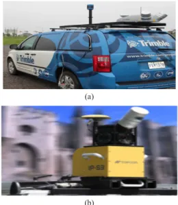
차량기반 모바일 매핑 시스템은 기술의 발전으로 상 용화 단계에 접어들었다고 할 수 있다. 기본적인 시스템 구성은 GNSS와 INS를 기반으로 카메라와 레이저 스캐 너, DMI 등의 센서를 탑재하고 있으며, 공간정보를 빠 르게 취득하는 데 목적을 두고 있다. 본 시스템은 일반적 으로 저가형과 고가형으로 구분할 수 있으며, 그림 2와 그림 3에 해당 시스템을 나타내었다[12-15].
(a)
(b)
Fig. 2. High-end Vehicle Based System (a) P model (b) V
model
(a)
(b)
Fig. 3. Low-end Vehicle Based System (a) M model (b) I model
고가형 시스템과 저가형 시스템의 가장 큰 차이는 INS 정밀도, 데이터 취득 거리 및 속도이다. 저가형 시 스템에 비해 고가형 시스템은 고속 주행 중에도 조밀한 데이터 취득이 가능하며, 정밀한 INS가 탑재되어있어 취득되는 데이터의 위치정확도를 향상 시킬 수 있다. 표 2~표 5에 각 시스템의 주요 사양을 나타내었다.
Item Description
Number of camera 6
Camera resolution 2,000,000 pixel
Scan range 270m
Scan speed 1,000,000pts/sec
Accuracy (horizontal) 0.020m RMS Accuracy (vertical) 0.015m RMS
Minimum scan range 0.3m
Table 2. Specification of high-end MMS – P model
Item Description
Number of camera 8
Camera resolution 9,000,000 pixel
Scan range 420m
Scan speed 600hz
Accuracy (horizontal) 0.050m RMS
Minimum scan range 1.2m
Table 3. Specification of High-end MMS – V model
Item Description
Number of camera 6
Camera resolution 2,000,000 pixel
Scan range 150m
Scan speed 72,000pts/sec
Accuracy (horizontal) 0.050m RMS Table 4. Specification of Low-end MMS – M model
Item Description
Number of camera 6
Camera resolution 5,300,000 pixel
Scan range 100m
Scan speed 700,000pts/sec
Accuracy (horizontal) 0.050m RMS Table 5. Specification of Low-end MMS - I model
일반적으로 차량기반 모바일 매핑 시스템은 카메라와 레이저 스캐너를 동시에 탑재하고 있지만, 카메라만을 운용하는 시스템도 출시되어 있다. 카메라만을 운용하는 경우 도입단가를 감소시킬 수 있다는 장점이 있다. 그림 4와 표 6에 카메라 기반의 모바일 매핑 시스템과 그 사 양을 나타내었다[14].
Fig. 4. Camera Based MMS
Item Description
Number of camera 6
Camera resolution 3,000,000 pixel
Accuracy (horizontal) 0.080m RMS
Table 6. Specification of camera based MMS
3. 실내용 MMS
실내 공간정보 구축에는 지상 레이저 스캐너가 주요 활용되어 왔다. 하지만 지상 레이저 스캐너는 벽으로 나 뉘어 있는 실내 공간의 데이터 취득을 위해 다수의 기준 점을 실내에 설치해야 하며, 기계를 많이 이동해서 설치 해야하는 등 단점이 있어 대형 건축물과 같이 복잡한 구 조를 가진 대상의 경우, 공간정보 구축을 위한 활용의 한 계가 있었다. 최근에는 이러한 단점을 해결하고 실내 공 간정보를 빠르게 취득하기 위해 고정밀 INS를 기반으로 한 실내용 모바일 매핑 시스템이 출시되어 복잡한 구조 의 건축물, 지하시설물 등 공간정보 구축의 적용 범위를 확장해 나가고 있다. 그림 5와 표 7에 실내용 모바일 매 핑 시스템과 그 사양을 나타내었다[14].
Fig. 5. Indoor MMS
Item Description
Number of camera 6
Camera resolution 2,000,000 pixel
Scan range 130m
Accuracy (horizontal,
vertical) 0.012m RMS
Table 7. Specification of Indoor MMS
4. Handheld형 MMS
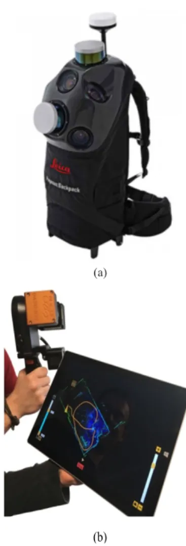
Handheld형 모바일 매핑 시스템은 차량기반 시스템 의 접근이 어려운 좁은 골목길이나 실내 공간 데이터 취 득을 위해 개발되었다. INS를 기반으로 장비의 위치를 파악하고, 스캐너로 취득된 데이터를 실시간으로 정합하 는 SLAM(Simultaneous Localisation & Mapping) 기술 이 적용된 제품이 출시되고 있다.
SLAM 기술은 관성항법장치 및 레이저 스캐너를 이 용하여 이동체가 자신의 위치를 측정하면서 동시에 주변 환경에 대한 지도를 작성하는 알고리즘이며, 포인트클라 우드 형상을 기반으로 한 자동 정합 기능을 제공한다. 그 림 6과 표 8~표 9에 해당 시스템과 그 사양을 나타내었 다[12,16].
(a)
(b)
Fig. 6. Handheld MMS (a) P model (b) G model
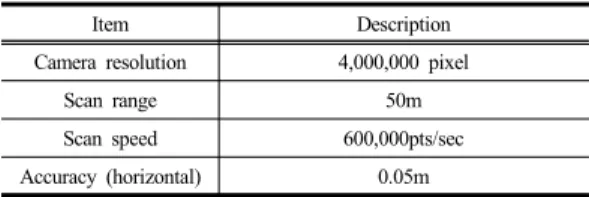
Item Description Camera resolution 4,000,000 pixel
Scan range 50m
Scan speed 600,000pts/sec
Accuracy (horizontal) 0.05m
Table 8. Specification of Handheld MMS – P model
Item Description
Camera resolution 2,700,000 pixel
Scan range 30m
Scan speed 43,200pts/sec
Accuracy (horizontal) 0.05m
Table 9. Specification of Handheld MMS – G model
모바일 매핑 시스템은 기존의 측량방법보다 데이터 취득의 속도 및 작업의 효율성을 향상시킴으로써 관련 업무의 생산성을 극대화 시키는 것을 목적으로 하고 있 다. 연구를 통해 조사한 차량기반, 실내용 및 handheld형 시스템의 특징을 표 10에 나타내었다.
Item Description
Vehicle-based MMS
• Fast data acquisition for outdoor
• High cost
• Launched low-cost products Indoor MMS • Fast data acquisition for indoor space
• High cost Handheld MMS • SLAM technology
• Low cost Table 10. Features of MMS
한편, 최근 모바일 매핑 시스템의 개발 방향은 장비 구성의 간소화, 저가형 센서 탑재 등 도입단가를 낮추는 방향으로 진행되고 있으며, handheld형 제품을 중심으로 자동 정합과 같은 신기술이 적용되고 있어 향후 공간정 보 구축 분야의 시스템의 적용 확대가 기대된다. 그림 7 은 최근의 모바일 매핑 시스템 개발동향을 나타낸다.
Fig. 7. Development trend of MMS
4. 결론
본 연구는 지상기반 모바일 매핑 시스템을 중심으로 상용화된 시스템의 현황 조사 및 특징 분석을 수행하여 관련 분야 기초자료를 제공하고자 한 것으로 연구를 통 해 다음과 같은 결론을 얻을 수 있었다.
1. 지상기반 모바일 매핑 시스템은 공간정보 구축 관련 업무의 생산성 극대화를 위해 실내 및 실외 공간에 대한 빠른 데이터 취득을 목적으로 하고 있다.
2. 최근 모바일 매핑 시스템의 개발 방향이 장비 구성 의 간소화, 저가형 센서 장착 등 도입단가를 낮추 는 방향으로 진행되고 있음을 제시하였다.
3. 새로운 자료처리 기술의 발달과 도입단가의 감소 는 모바일 매핑 시스템의 적용을 활성화시킬 수 있으며, 공간정보를 기반으로 하는 증강현실, 자 율주행 자동차 개발 등 관련 산업 발전에 기여할 것이다.
References
[1] Y. S. Jwa, G. H. Sohn, J. U. Won, W. C. Lee and N.
H. Song, “Railway Track Extraction from Mobile Laser Scanning Data”, Journal of the Korean Society of Surveying, Geodesy, Photogrammetry and Cartography, vol. 33, no. 2, pp. 111-122, 2015.
DOI: https://doi.org/10.7848/ksgpc.2015.33.2.111 [2] K. W. Lee, “Extraction of Road Information Based on
High Resolution UAV Image Processing for Autonomous Driving Support”, Journal of the Korea Academia-Industrial cooperation Society, vol. 18, no. 8, pp. 355-360, 2017.
DOI: http://dx.doi.org/10.5762/KAIS.2017.18.8.355 [3] J. W. Kim, J. W. Kim, and J. J. Chae, "A Review of
Routing Plan for Unmanned Aerial Vehicle : Focused on In-Country Researches", Journal of Society of Korea Industrial and Systems Engineering, Vol. 38 No. 4, pp.
212-225, 2015.
DOI: https://doi.org/10.11627/jkise.2015.38.4.212 [4] S. Y. Won, S. W. Lee, J. C. Paik, C. Y. Yune and G.
H. Kim, “Analysis of Erosion in Debris Flow Experiment Using Terrestrial LiDAR”, Journal of the Korean Society of Surveying, Geodesy, Photogrammetry and Cartography, vol. 34, no. 3, pp. 309-317, 2016.
DOI: https://doi.org/10.7848/ksgpc.2016.34.3.309 [5] J. K. Park, M. G. Kim, “Application of Scanning Total
Station for Efficiency Enhancement of Tunnel Surveys”,
Journal of the Korea Academia-Industrial cooperation
[6] D. G. Lee, D. C. Lee, “Key Point Extraction from LiDAR Data for 3D Modeling”, Journal of the Korean Society of Surveying, Geodesy, Photogrammetry and Cartography, vol. 34, no. 5, pp. 479-493, 2016.
DOI: https://doi.org/10.7848/ksgpc.2016.34.5.479 [7] H. B. Kim and H. S. Kim, "Optimal Satellite
Constellation Design for Korean Navigation Satellite System", Journal of Society of Korea Industrial and Systems Engineering, Vol. 39 No. 3, pp. 1-9, 2016.
DOI: https://doi.org/10.11627/jkise.2016.39.3.001 [8] S. P. Choi, J. H. Ham, M. S. Kim, I. T. Yang and U.
N. Kim, “Slope Terrain Analysis According to Geographical Feature and Survey Place Based on Terrestrial LiDAR Data”, Journal of the Korean Society for Geospatial Information System, vol. 18, no. 2, pp.
63-68, 2010.
[9] Seoul[cited 2017 Sep. 10], Available From:, http://gis.
seoul.go.kr/
[10] J. K. Park and E. S. Lee, “Applicability Estimation of Mobile Mapping System for Eefficient Construction of Road Geospatial Information”, Journal of the Korean Association of Cadastre Information, vol. 16, no. 2, pp.
185-192, 2014.
[11] National Geographic Information Institute[cited 2017 Sep. 6], Available From: www.ngii.go.kr
[12] Leica Geosystems[cited 2017 Sep. 10], Available From:
http://leica-geosystems.com
[13] RIEGL Laser Measurement Systems GmbH[cited 2017 Sep. 10], Available From: http://www.riegl.com/
[14] Trimble Inc.[cited 2017 Sep. 11], Available From:
http://trimble.com
[15] Topcon Corporation[cited 2017 Sep. 5], Available From:
https://www.topconpositioning.com
[16] GeoSlam[cited 2017 Sep. 6], Available From: https://
geoslam.com/
박 준 규(Joon-Kyu Park) [종신회원]
• 2001 년 2 월 : 충남대학교 공과대 학 토목공학과 ( 공학사 )
• 2003 년 2 월 : 충남대학교 대학원 토목공학과 ( 공학석사 )
• 2008 년 8 월 : 충남대학교 대학원 토목공학과 ( 공학박사 )
• 2011 년 3 월 ∼ 현재 : 서일대학교 토목공학과 부교수
< 관심분야 >
지형공간정보공학
엄 대 용(Dae-Yong Um) [정회원]
![표 1은 지상기반 모바일 매핑 시스템 관련 주요 프로젝 트 현황을 나타낸다[11].](https://thumb-ap.123doks.com/thumbv2/123dokinfo/5132231.581376/2.799.93.381.569.757/지상기반-모바일-매핑-시스템-관련-프로젝-현황을-나타낸다.webp)