• 검색 결과가 없습니다.

A Study on the Development Strategy for Future GeoSpatial Open Platform

N/A
N/A
Protected

Academic year: 2021

Share "A Study on the Development Strategy for Future GeoSpatial Open Platform"

Copied!
10
0
0

로드 중.... (전체 텍스트 보기)

전체 글

(1)





*

**

***

This work was supported by the 2013 Research Fund of the University of Seoul.

MoonGie Kim, Ph.D Candidate, Dept. of GeoInformatic Engineering, University of Seoul. [email protected] DongHyeon Yoon, Ph.D Candidate, Dept. of GeoInformatic Engineering, University of Seoul. [email protected]

JuneHwan Koh, Professor, Dept. of GeoInformatic Engineering, University of Seoul. [email protected] (Corresponding Author)

A Study on the Development Strategy for Future GeoSpatial Open Platform

미래 공간정보 오픈 플랫폼의 개발전략에 관한 연구

MoonGie Kim ․ DongHyeon Yoon ․ JuneHwan Koh

김문기* ․ 윤동현** ․ 고준환***

요 약 1995년 이후 수행된 국가지리정보체계(NGIS) 사업에 따라 중앙정부와 지방자치단체는 많은 공간정보를 축적 하였으며, 국토교통부는 2012년 1월 공간정보 오픈플랫폼(V-World) 서비스를 시작하여 다양한 기능과 서비스를 제공 하고 있다. 하지만 사용자가 실질적으로 원하는 데이터와 민간의 비즈니스 영역에서 활용하기 위한 데이터 부재, 지자 체에서의 활용 및 홍보 부족 그리고 민간협력 미흡 등의 난제로 국가 공간정보 플랫폼으로써의 확실한 돌파구를 찾지 못 하고 있는 실정이다. 공간정보 오픈플랫폼이 서비스 된지 3년이 지난 현재의 연구동향을 분석하면, 주로 해외진출, 연 계, 서비스개선, 활용, 향후전략에 대한 연구가 진행되어 왔다. 본 연구에서는 선진 해외의 공간정보 플랫폼 구축동향과 국내 연구동향을 분석하여, 신기술과 비즈니스 플랫폼의 개념, 서울시 공간정보 플랫폼 등을 종합하여 미래 공간정보 오픈 플랫폼의 구축을 위한 정책을 제시하고자 한다.

키워드 : 공간정보 오픈 플랫폼, 비스니스 플랫폼, 링크드 오픈 데이터(LOD), 서울디지털기본계획 2020

Abstract According to the NGIS (National Geographic Information System) project conducted since 1995, the central and local government has been accumulating huge amount of geospatial data. Korean Ministry of Land, Infrastructure and Transport started its GeoSpatial open platform (V-World) service in January 2012, also offering a wide range of functions and services. However, the National GeoSpatial open platform is still woefully deficient for the users to find their desired data, lack of data for private business area, insufficient in publicity of local government and public-private partnerships. Through analyzing current research trend after GeoSpatial open platform served for three years, study on overseas expansion, system links, service improvement, utilization and future strategy has been mainly conducted. This study, by analyzing the advanced overseas GeoSpatial platform as well as domestic research trend and combining the concept of new technology, business platform and SMG (Seoul Metropolitan Government)’s GeoSpatial platform, proposes a policy for the construction of future GeoSpatial Open Platform model.

Keywords : GeoSpatial open platform, Business platform, Linked Open Data (LOD), 2020 Seoul digital general plan
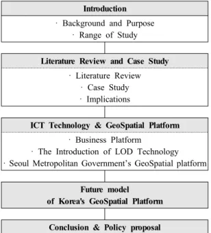
1. Introduction

1.1 Background and Purpose

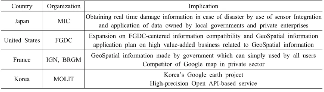
Currently, Platform development requirements for the sake of more effective utilization of diverse GeoSpatial information are growing. Since 1995, the central gov- ernment and local government have been accumulating GeoSpatial information as per NGIS. Korean MOLIT (Ministry of Land, Infrastructure and Transport) starts its GeoSpatial open platform (Korean version of Google Earth) “V-World” service, offering GeoSpatial information

such as Imagery map, 3D building and topography, ad-

ministration border, traffic facility and cadastral map,

etc. However, according to the introduction of the lat-

est ICT (Information Communication Technology) and

rapid change of GeoSpatial information ecosystem, a

future-oriented platform has to be conducted for the

survival of the existing GeoSpatial platform and more

usage for the public. This study analyses previous re-

searches and cases regarding GeoSpatial platform, and

elaborates future image of GeoSpatial platform by in-

troducing new technologies and the advanced ICT serv-

ices applied by SMG GeoSpatial platform.

(2)

Table 1. Structure of this study Introduction

· Background and Purpose

· Range of Study

Literature Review and Case Study

· Literature Review

· Case Study

· Implications

ICT Technology & GeoSpatial Platform

· Business Platform

· The Introduction of LOD Technology

· Seoul Metropolitan Government’s GeoSpatial platform

Future model of Korea's GeoSpatial Platform

Conclusion & Policy proposal

1.2 Range of Study

We are currently meeting various kinds of platforms in our general life no matter anywhere in the world.

According to the analysis by Professor Thomas R.

Eisenmann from Harvard University, sixty percent of the top 100 companies in terms of global market capi- talization are doing business by the use of platform.

Companies who led the internet revolution, such as Google, Apple, Amazon, Facebook, etc. have conducted their own powerful platform to create a focal point for connecting a wide range of people. Platform is no lon- ger simply used in business area but also taken advant- age of by the public institutions in developed countries such as the United States. However, despite such in- creasing interest and vigorous discussion in platform, the definition of platform is still not clear[27]. The platform we are in contact with everyday such like Apple, Facebook, Google, Kakao Talk as well as smart phone OS, are developing in their own ecosystem for surviving. Thus, this study elaborates the necessity to present a direction of strategy to survive in the GeoSpatial information ecosystem like other local private compa- nies while pushing forward the GeoSpatial open plat- form business. The main content of the study is as table 1 shows.

2. Literature Review and Case Study

2.1 Literature Review

Table 2 shows the research papers regarding GeoSpatial open platform in Korea from 2012 to 2015. The research papers are mainly published in 2014 and the content mainly includes five areas, these are Overseas Expansion, System Links, Service improvement, Utilization and Future strategy. Figure 1 shows the number of papers in each area. GeoSpatial open platform is studied and analyzed in various fields, through that, efforts on changing in the ecosystem of GeoSpatial information based on the result of study can be found. However, studies on the introduction of platform concept being used in private sector, new technology of IOT, LOD, etc. and GeoSpatial platform which have already in- troduced in developed countries are still not satisfactory.

This paper makes a study mainly on the future strategy to develop GeoSpatial open platform.

2.2 Case Study

2.2.1 Japan’s G-Spatial Platform

Japanese MIC (The Ministry of Internal Affairs and Communications) first develops and demonstrates the functions of data retrieval, processing and analysis.

Then, by utilizing the sensor, they are able to identify the information of damage in real time when disasters happen. After that, they have a plan to use and in- tegrate the data of local government with private com- panies and conduct the G-Spatial Platform soon in the near future to maintain and manage those data[23,29].

In addition, map data, static data (hazard map information, geological information, statistical data), and the dy- namic data (weather information, probe information, the sensor information), as the GeoSpatial information held by private companies, is now being conducted to be used in combination.

2.2.2 The United States’ GeoSpatial Platform

In the case of the US, the FGDC (Federal Geographic

Data Committee) was established in 1990 in accord-

ance with the OMB (Office of Management and Budget)

Circular A-16 as a whole governmental organization

to push forward the National geospatial information

(3)

Table 2. Literatures GeoSpatial Open Platform related (Since 2012)

Researcher Research Area Summary

Jeong(2014)

Overseas Expansion

Set priority target countries through the AHP and statistics of variables[6]

Lim(2014) Problems and Improvement Plan for Overseas Expansion[19]

Jeong(2014) Review on Suitability for GeoSpatial industrialization and platform market [7]

Kim(2014) A Plan on Export Model under consideration of characteristic of Cambodia and Abu Dhabi[12]

Kim(2014)

System Link

Technology and Policy Plan for Single Point Access platform link model[10]

Yeon(2014) Interface Server Model for Data Link between Public Data Portal and Open Platform [31]

Kim(2014) Analysis of Phase Relation and Investigation of Domestic geospatial open platform by different update period [11]

Kang(2014)

Service Improvement

A Study on Guidance Production for activation [9]

Lee(2014) Case study on System Failure due to Access congestion of open platform[18]

Lee(2014) Analysis and Result on Use state of web user log information[17]

Lee(2014)

Utilization

Development on Outdoor mine Monitoring System by GeoSpatial open platform and Open source GIS Tool[16]

Kim(2014) A study on Establishment of facility management system by the use of V-world Open API[13]

Lee(2014)

Future Strategy

A Plan and Consideration on Cloud sensing platform for activation[15]

Lee(2014) A plan on Mobile cloud-sensing platform for Expansion of users[14]

Jeong(2013) A study on the Strategy for GeoSpatial information-based Social platform[5]

Jin(2013) Service Improvement Analysis and Satisfaction survey on Members and Visitors[8]

Oh(2013) Utilization A Study on GeoSpatial service by V-World for Improvement of Competitiveness of Tourist Industry[25]

Choi(2012) Future Strategy Necessity on Conversion of GeoSpatial social platform suitable for a Smart Society [2]

Figure 1. Study area analysis

business.

After that, NSDI (National Spatial Data Infrastructure) was announced in 1994 in accordance with Presidential Decree No.12906. Then, with FGDC as the center, GeoSpatial platform development was launched in 2010 for expanding the compatibility and utilization

of the information. Through the establishment of NDGDF (National Digital GeoSpatial Data Framework) and promotion of the geospatial information related public-private cooperation system, a wide range of high added value business related to geospatial information was driven to provide a better service to the consumers.

Based on the OMB A-16 Supplemental Guidance[4]

published in 2010, the DOI (US Department of the Interior)

and FGDC announced “Modernization Roadmap for

the GeoSpatial Platform”in 2011 and “Business Plan

for the GeoSpatial Platform” in 2012, presenting the

purpose, business model, implementation and perform-

ance goal of the GeoSpatial platform. Figure 2 shows

the progress of GeoSpatial Initiatives led by the FGDC.

(4)

Figure 2. Progression of GeoSpatial Initiatives Led by the FGDC[3]

Figure 3. The service contents of V-world 2.2.3 France’s Geoportail

Geoportail is a comprehensive web mapping service of the French government that publishes maps and aer- ial images from more than 90 sources for France and its territories. The service, first developed by two pub- lic agencies the IGN (Institut géographique national) and the BRGM (Bureau des recherches géologiques et minières), was officially inaugurated on June 23, 2006 by president Jacques Chirac[32]. Though the French service has sometimes been described as a competitor or rival to Google Maps, it is different from Google's mapping service, since they have different objectives.

Geoportail makes some unusual cartographic sources available, such as the renowned 18th-century Cassini maps and the Napoleonic-period Minutes etat-Major, in addition to IGN road maps, administrative maps, topographic maps, cadastral and building surveys, pub- lic service utility maps, transportation maps, hydro- graphic maps, atmospheric and weather maps, geological maps, land use maps, maps of cultural sites, and much more. Since its inception in June 2006, the French serv- ice has progressively added new data and undergone significant updates. Geoportail project can largely div- ided into two parts-Geoportail and Geoportail Services.

Geoportail provides the function for searching and viewing the GeoSpatial information in all public sec- tors, while Geoportail services offer common service functions for viewing and downloading GeoSpatial da- ta, including particular services provided by IGN and its cooperation institutions.

2.2.4 Korea’s GeoSpatial Open Platform

V-world, that is Korea’s geospatial open platform, plays a role as the platform for national geospatial in- formation as well as private cooperation and open government. The study of GeoSpatial open platform

development by the MLIT (The Ministry of Land, Infrastructure and Transport) carried out in 2010, pre- senting a blueprint on service conditions and analysis of the open platform, long-term road map and detailed step-by-step promotion plan, as well as the distribution plan for 3D map data. The MLIT began to launch the high precision Open-API based GeoSpatial open plat- form (V-World), so-called “the Korean version of Google Earth”, in May 2011. Figure 3 shows the serv- ice contents of V-World.

2.3 Implications

Korea’s geospatial open platform based on High-res- olution 3D map is built to integrate and process a varie- ty of national geospatial information in order to offer a desired open platform for the users. Nowadays it is getting more interest and participation from the users.

Despite the point that 3D information service should

be the center of geospatial open platform, other serv-

ices such as cadastre and land use zoning map viewing

is also being offered and each service is individually

(5)

Table 3. Comparison and analysis of each country's GeoSpatial platform

Country Organization Implication

Japan MIC Obtaining real time damage information in case of disaster by use of sensor Integration and application of data owned by local governments and private enterprises United States FGDC Expansion on FGDC-centered information compatibility and GeoSpatial information

application plan on high value-added business related to GeoSpatial information France IGN, BRGM GeoSpatial information made by government which can simply used by all users

Competitor of Google map in private sector

Korea MOLIT Korea’s Google earth project

High-precision Open API-based service

operated, which become even more inconvenient for the users. It is necessary for the geospatial open plat- form to be built on a system where each area is specialized.

Therefore, private industries and the public can view, merge and distribute the geospatial information more conveniently. Table 3 shows the comparison and analy- sis of GeoSpatial platform of each country. As in- troduced above, without both the know-how like the advanced European country France and the content re- garding specialized business model such like The US’s geospatial platform, Korea’s geospatial open platform is still not satisfactory. In this study, elements for the development of GeoSpatial Open Platform are in- troduced in Chapter 3.

3. ICT Technology & GeoSpatial Platform

It is a common fact that the development of in- formation processing technology is the main com- petitiveness in the field of geospatial information. This indicates the creation of knowledge-intensive added value will be the essential element during the establish- ment of the national geospatial system. However, this technology is still lack of maturity in both quality and quantity compared with the developed countries. In or- der for the geospatial platform to grow sustainably with more practical value, a paradigm shift in the field is most necessary of all. First, since strategic option is different depending on type of environment and eco- system, it is necessary to introduce the concept of busi- ness platform and make flexible strategies for different environment in order for the platform to survive.

Second, instead of the existing system link and en-

hanced Open API, introduction of LOD makes it possi- ble to form a linking relationship between data. Third, it is necessary for public institutions to quickly introduce Big Data and the new ITC technology IOT, as well as examining and introducing the general plan of Seoul Metropolitan Government on service. In this section, each of the above content will be described in details.

3.1 Concept of business platform

Business platform is platform where several partic- ipants create economic value in accordance with com- mon specifications or rules. As the platform is activated, the number of participants increases, causing more op- portunities and a virtuous circulation.

On the other hand, the value of platform in operation should be monitored in accordance with the alternation of the external environment such as market and tech- nology[26]. Platforms in all the fields including manu- facturing and service industries are evolving in various forms in order to enhance business efficiency and mar- ket power. It is essential to establish the platform strat- egy effectively so that platform can be successfully formed and activated in the ecosystem of each relevant field. Figure 4 shows the step-by-step strategy of plat- form business. Platform strategy is to make appropriate choices and decisions when disadvantages occur in the stage of excavation, introduction, growth, enrichment and harvest. Since strategic choices vary depending on the type of the ecosystem, it is necessary to use flexible strategy according to each situation and condition[1,30].

Table 4 shows study related to geospatialopen platform,

promotion strategy and considerations of business plat-

form strategy over past three years, based on the analy-

(6)

Table 4. Strategy of business platform and considerations in each field

Area Requirements Main Strategy Consideration

Database ·Making geospatial data catalog

·Updating and quality control

·Establishing high quality

·GeoSpatial data and open ex- pansion

·Preparing business-based update sys- tem

·Enhancing quality of geospatial data

·Searching new geospatial R&D

Utilization

·Understanding associative relationship of geospatial industry

·Converting to circulation of interested parties

·Breaking from public

institution-focused problem solution

Technology &

System Link

·Improving hierarchical structure

·Unifying service being offered

·Applying open platform technology

·Establishing data infrastructure for customized information supply

·Service model with complementary relation

Global Market

·Establishing foundation for overseas expansion

·Establishing continuous overseas network

·Knowledge platform establishment and operation for overseas expansion

·Foundation establishment and role strengthening for overseas expansion

·Offering customized information and service support

Figure 4. The step-by-step strategy of platform business sis on the study of the leading business[20,21,22].

GeoSpatial open platform is at present in the position of the critical point to enter stage 3 (Growth) and stage 4 (Enhancement). In order to introduce the open plat- form, relevant study has been carried out since 2010 and has been pushed ahead in accordance to the plan- ned roadmap and implementation strategies, seeking to develop through a variety of research for advancement.

However, it is still lack of domination in the role of national geospatial platform, public-private partner- ships and information disclosure and application, and it is failed to play an important role during the actual utilization. Through the analysis of previous studies, there is a necessity to establish a mutual communication system instead of the one-sided information provision form and develop a strategy to support the link among

data from different platform. Also, development of new GeoSpatial R&D, getting rid of public institution fo- cused problem solution, customized information supply and considerations for service support have to be examined.

3.2 Introduction of LOD Technology

The founder of 3W (World Wide Web) Tim Berners- Lee once had a speech in TED talks, where he empha- sized the propagation of Linked Data in order to foster not only the development connection between web documents but also the connection of data. Recently, with the interest in big data, studies on the application plan by accumulated data analysis are being conducted.

In this environment, the introduction of LOD (Linked Open Data) gains general attention. Through this tech- nology, it is able to correlate the data that is distributed on the web for the purpose of utilization and applica- tion of public data.

LOD is able to make Web itself a global database

so that anyone is free to open and use data as well

as creating new services based on data. LOD is now

being offered in the developed countries such as the

United States and the United Kingdom where the next

generation of technical transform of public data has

been accelerated. In Korea, LOD is now being pro-

vided in some areas such as medical treatment and the

(7)

Figure 5. Link & offer state after the introduction of LOD

Figure 6. The stage of data economy Source: Gartner(2011)[27]

library. Figure 5 shows the concept of service platform by connecting LOD technology with individual estab- lished data through comparing the linking and offering form of public data in the field of geospatial in- formation after the introduction of LOD Technology[24].

Effective service development has now been carried out vigorously in accordance with the actively pro- moted activation of open public data. The collection of most non-structured data is easy while it is difficult for them to be utilized and processed. Also, it is more difficult for the users to obtain desired results based on given data. Therefore, open platform where data can be easily found and used come to be necessary.

Through conversion to data platform, it is possible to expand the range of service and provide more functions for the convenience of data open and utilization.

Except that, it also enables the improvement of date in both quality and quantity so that establishment of data infrastructure is available for setting semantic con- nection in the center of data. Eventually, the effort on disclosure of information by the government agencies can increase government transparency and encourage citizen participations so that new business is possible based on the reproduced customized information such as the convergence of private data.

Through the application and establishment of LOD, it is possible to build linking relationship between dif- ferent data on the web. It is meaningful to form the circulation that many data can be freely utilized and combined to reproduce new information. As figure 6 shows, these policies can be defined as the top level of the activity to maximize the social and economic significance of the data.

3.3 SMG (Seoul Metropolitan Government)’s GeoSpatial platform

At present, domestic platform which is similar to ge- ospatial open platform is Community Mapping, Seoul map homepage and Seoul policy map etc. served by SMG(http://gis.seoul.go.kr). As mentioned above, in point of platform, SMG has reached the similar critical point with the geospatial open platform. Therefore,

“2020 Seoul Digital General Plan” is developed at the

beginning of 2015 in order to activate and develop the

platform under the vision of realizing data-based digital

Seoul[28]. Among them, IOT (Internet Of the Things)

and Big Data applied technology as well as socio-

economically high-value expansion of Open Data Plaza

(http://data.seoul.go.kr) are worthy of notice. In partic-

ular, SMG Big Data is planned to take advantage of

data-based administration to open various information

and provide new civil service through Open Data

Plaza. The plan will be established specifically in the

(8)

Figure 7. 2020 Seoul Digital General Plan[28]

Figure 8. Future Model of Korea’s GeoSpatial Open Platform future, while LOD concept is estimated to be introduced

for open and more participation of users by viewing the content regarding the construction of SMG Big Data Hub for data sharing and application.

4. Future Model of Korea’s Geo- Spatial Open Platform

In case of geospatial area, through geospatial open platform, it functions as platform related to national geospatial information as well as private cooperation and open platform, however, some selected data by the providers and data in high demand is limitedly provided.

Despite the quantitative expansion, utilization of data appears to be low compared with the situation in the developed countries. Also, promotion strategies based on the standard in 2010 fails to reflect paradigm shift of the consumers and are considered to be necessary to redefine as a platform. The above chapter 3 regard-

ing concept of business platform and new technology are not described in any previous studies or research papers. Through the introduction of LOD (Linked Open Data) technology for a more efficient open and use of data and the newest ICT technology introduced by Seoul Metropolitan Government, it is necessary for The Ministry of Land, Infrastructure and Transport to change the direction of future development of GeoSpatial open platform. Figure 8 introduces the footsteps geo- spatial open platform have developed so far and the concept, new technology as well as cases of business platform discussed in this study, suggesting future geo- spatial platform model of Korea. Based on the above contents, Chapter 5 proposes policies for the develop- ment of National geospatial open platform.

5. Conclusion and policy proposal

The national geospatial information now occupies huge amounts of national key data, of that, safety data and real estate information shows a greatly high demand.

As the actual demand reflects, geospatial open plat- form is offering services including cadastre and land use zoning map, and some part of it overlaps the serv- ice offering in the system of Real Estate Total Service.

Thus, in order to increase the private utilization of

the national geospatial information and establish a vir-

tuous circulation, a citizen-customized platform should

be rebuilt from the data which is intended for use of

government agencies, where paradigm shift and new

(9)

technology trend can be reflected. It is hard to expect an improvement of the quality of information by a service provider that fails to reflect the demand of the consumers. As the case of SMG shows, under the con- sideration of various agents by the utilization of data (such as private-public, public-public, private-private), implementation strategies are needed in order to max- imize the value as well as the creation and utilization of new value through mutual contact of data. As Figure 8 shows, Korea’s geospatial open platform should fo- cus on building the base or the ecosystem rather than a completed service, and support activity agents on in- formation communication. Also, it has to be built in an open and conjugation form, laying emphasis on the creation of the new added value.

Based on the investigation and analysis, recom- mendations related to the introduction of geospatial open platform are as follows.

First, a strategy regarding the conversion from en- hanced Open API to LOD is necessary. Also, after the introduction of the definition of LOD, research on link application of LOD should be planned.

Second, national geospatial open platform and SBD (Spatial Big Data) platform should be converted with more functions like the case of SMG (Seoul Metropolitan Government), building its own style of big data platform.

Third, private consultancy study on platform en- hancement as the definition of business platform this study introduces is needed. In order for the current geo- spatial open platform to survive, the reestablishment of platform model is also necessary.

Fourth, cloud-based platform has been introduced and operated in private companies. It is also necessary for the central government to convert the environment of geospatial open platform into cloud-based platform.

Fifth, as the case of Japan shows, future plan regard- ing the application and link of SNS data which can see the flow of public opinions to private geospatial information should be conducted.

Through the above study and proposal, it is expected for the national geospatial open platform to build a foundation to survive in the future that lies ahead.

References

[1] Choi, B. S. 2014, Platform Changes Business, Samsung Economics Research Institute.

[2] Choi, W. W; Hong, S. K; Shin, D. B; Ahn, J.

W. 2012, Concept of Spatial Information Social Platform and Role of Government as a Platformer, Journal of Korea Spatial Information Society, 20(4):37-45.

[3] FGDC, 2012, Business Plan for the Geospatial Platform(Redacted).

[4] FGDC, 2010, Geospatial Line Of Business OMB Circular A-16 Supplemental Guidance.

[5] Jeong, J. D; Ahn, J. W; Shin, D. B. 2013, A Study on the strategy for spatial information-based social platform, The annual spring conference for Korean Society for Geospatial Information System, 135-138.

[6] Jeong, J. D; Han, S. H; Lee, J. Y. 2014, A Study to Establish the Expansion Strategies through the Classification of Overseas Countries for Spatial Open Platform Export, Journal of The Korean Cartographic Association, 14(2):73-87.

[7] Jeong, J. D; Lee, J. Y. 2014, Constructing Overseas Expansion Package of Spatial Information Industry Based on Platform Economics, The annual fall conference for Korean Society for Geospatial Information System, 127-128.

[8] Jin, A. K; Jung, R. H. 2013, A Study on User Satisfaction Surveys and Analysis for Improvement of the V-World Service, Journal of Korea Spatial Information Society, 22(6):23-32.

[9] Kang, J. A; Sung, K. S. 2014, A Study on Making Beginner Utilization Guide of the Spatial Information Open Platform, Journal of Cadastre, 44(1):151-164.

[10] Kim, B. S; Ahn, J. W; Shin, D. B. 2014, A Study on the Construction of Service-oriented Connection Model among National GeoSpatial Information Platforms, Journal of Korea Spatial Information Society, 22(2):11-18.

[11] Kim, B. S; Ahn, J. W; Shin, S. B. 2014, A Study

on Formulating Topological Relationship between

National Geospatial Platforms, The annual spring

conference for Korean Society for Geospatial

Information System, 79-81.

(10)

[12] Kim, K; Jeong, J. D; Lee, J. Y. 2014, A Study on Abroad Export Strategy by Country of Spatial Open Platform -Focused on the Kingdom of Cambodia and the Emirate of Abu Dhabi-, Journal of Korea Spatial Information Society, 22(3):9-21.

[13] Kim, W. K; Kim, H. R; Seo, Y. M. 2014, How to build facilities maintenance management system applying open platform V WORLD Open API, The annual fall conference for Korean Society for Geospatial Information System, 195-196.

[14] Lee, C. H; Jang, I. S; Kim, M. S. 2014, Design and Implementation Strategy of Mobile Crowdsensing Platform for Proliferation of V-World Map, The annual fall conference for Korean Society for Geospatial Information System, 117-118.

[15] Lee, C. H; Kim, M. S; Shin, S. W. 2014, Survey on Geospatial Crowdsensing Platform for Prolifera- tion of V-World Map, The annual spring conference for Korean Society for Geospatial Information System, 267-268.

[16] Lee, H. J; Kim, S. Y; You, J. H. 2014, Development Environment for Open-pit Mine Monitoring System using Geospatial Open Platform and Open Source Software, Journal of the Korean Society for Geospatial Information System, 22(4):165-173.

[17] Lee, S. H; Cho, T. H; Kim, M. S. 2014, A Study on the Service Status of the Spatial Open Platform based on the Analysis of Web Server User Log:

2014.5.20.∼2014.6.2. Log Data, Journal of Korea Spatial Information Society, 22(4):67-76.

[18] Lee, S. H; Cho, T. H; Kim, M. S; Jang, I. S.

2014, A Case Study on System Fault of the Spatial Open Platform, The annual fall conference for Korean Society for Geospatial Information System, 115-116.

[19] Lim, Y. M; Han, S. H; Lee, J. Y. 2014, The Current Status and Problems for Overseas Expansion Support of The Korea Spatial Information Open Platform(V-World), The annual spring conference for Korean Society for Geospatial Information System, 247-250.

[20] Ministry of Land, Infrastructure and Transport, 2014, The improvement of Architecture and software for the GeoSpatial Open Platform, Infrastructure R&D report.

[21] Ministry of Land, Infrastructure and Transport.

2014, The activation and Export Competitiveness for the GeoSpatial Open Platform, Infrastructure R&D report.

[22] Ministry of Land, Infrastructure and Transport.

2014, The assurance and improvement of data processing technology for the GeoSpatial Open Platform, Infrastructure R&D report.

[23] Mizuhiko, H, 2015. The Overview of G-spatial Platform Development, The 10th. Open Symposium of CSIS-i, University of Tokyo.

[24] National Information Society Agency. 2014, The Paradigm shift strategy of LOD based Data management, IT & Future Strategy 2014(1).

[25] Oh, M. W; Kim, H. J; Koh, J. W. 2013, A Study on the Development of the Tourism Information Service based on a Service Science - Focus on Using VWORLD -, Journal of Korea Spatial Information Society, 21(1):23-36.

[26] Samsung Economics Research Institute. 2012, The Business ecology & platform strategy, SERI research report.

[27] Samsung Economics Research Institute. 2011, The emerging business platform & implication, CEO Information 802.

[28] Seoul Metropolitan Government. 2015, 2020 Seoul Digital General Plan internal report.

[29] Spatial Information Research Institute. 2014.10, The issue of Land & GeoSpatial, 1-9.

[30] Spatial Information Research Institute. 2014, A Study of management system reorganization for Geospatial Information System.

[31] Yeon, S. H; Lee, I. S; Tcha, T. K. 2014, Interface Server Model for the Effective Data Link between Public Data Portal and Open Platform, Journal of Cadastre, 44(1):113-125.

[32] Wikipedia, s.v. “Geoportail”, last modified November 2, 2014, http://en.wikipedia.org/wiki/Geoportail.

Received:2015.03.17

Revised :2015.04.28

Accepted:2015.04.29

수치

Table 1. Structure of this study Introduction
Table 2. Literatures GeoSpatial Open Platform related (Since 2012)
Figure 3. The service contents of V-world2.2.3 France’s Geoportail
Table 3. Comparison and analysis of each country's GeoSpatial platform
+4

참조

관련 문서

the Smart City Platform The City Integrated Operation Center.

This paper examines China's ICT development awareness and strategy, support policy and technical cooperation network since the China’s Reform and Open Policy

Keywords: Computational Science and Engineering Platform, EDISON Platform, Information Systems Success Model, Technology Acceptance Model, Structural Equation

Another platform for academic projects is proposed by [14], based on Raspberry Pi and Arduino boards as hardware platforms and ThingSpeak as a software and communication

NISSAN Leaf

 All in One platform 기반 전사 연계시스템 구축.  통합

The intent of the Strategy is to design, foster and build synergies for activities and investments in geospatial information management in the United Nations

Global Second tier Multi Platform 시가총액 1,000~7,000억달러 미만.. Local Single Platform