풍수해 피해 추정을 위한
공간정보 DB의 활용방안 및 품질 점검 기준 제안
*
Proposal for application of spatial data and quality check criteria for estimating
damage from storm and flood
원석환** · 김현덕*** · 김상민****
Won, Seok-Hwan · Kim, Hyeon-Deok · Kim, Sang-Min Abstract
The purpose of this study was to propose applicability of spatial data and quality check criteria for estimating damage from storm and flood.
Using the data from the National Disaster Management System and National Spatial Data Infrastructure, spatial database for estimation of storm and flood damage has been mapped to each type of damage. This was proposed as the quality check criteria for damage analysis.
Through this study, it is possible to utilize the spatial database for estimating storm and flood damage. The reliability of analysis results are ensured through the quality check criteria.
Keywords: Damage from Storm and Flood, Damage Estimation, Spatial Data Quality, Disaster Information
1. 서 론
최근 장기간의 장마와 잦은 태풍으로 인해 수많은 피해가 발생하였는데, 이와 같이 태풍, 홍수, 호우 등 과 같은 강한 바람이나 물에 의해 발생하는 자연재해 를 풍수해라 한다. 풍수해를 비롯한 자연재해의 피해 추정 및 예방, 복구계획 수립 등의 자연재해 복구지원 체계를 효율적으로 운영하기 위해서는 피해 전과 후 의 상황에 대한 상세한 정보가 필요하다. 따라서 피해 현장에 대한 시계열적 데이터의 선제적 구축과 피해 상황에 대한 상세한 현황정보 구축이 필수적이다. 현재 「재난 및 안전관리 기본법」과 「자연재해대책 법」에 근거하여 자연재해로 인한 피해 조사를 실시하 고 있지만, 주로 현장 조사를 통해 텍스트 중심으로 데 이터베이스가 구축되고 있다. 또한 자연재해발생 및 피해량이 등록된 국가재난관리정보시스템(National Disaster Management System, 이하 NDMS)의 자료 를 바탕으로 매년 생산되는 재해연보 역시 텍스트 중* 본 연구는 행정안전부 재난안전 산업육성지원 사업의 지원을 받아 수행된 연구임(no.20009742). ** LX 공간정보연구원 선임연구원 LX Spatial Information Research Institute (first author: [email protected]) *** LX 공간정보연구원 연구원 LX Spatial Information Research Institute ([email protected])
심으로 작성되고 있다. 자연재해로 인해 발생하는 물리적, 사회경제적 피 해는 연쇄적인 반응을 일으켜 지역경제, 더 나아가 국 가 경제 및 사회 전반에 영향을 미칠 수 있지만, 아직 까지 국내에서는 물리적 손실에 국한된 손실조사로 피해 규모가 과소 집계되고 있다(현수현・김학열 2017). 구체적이고 다각적인 자연재해 피해 추정을 위해서 는 기존에 진행되고 있는 텍스트 중심의 데이터가 아 닌 GIS 기반의 자연재해 공간정보의 구축 및 활용이 필수적이다. 자연재해의 피해 추정을 위해서는 자연 적인 요인과 인위적인 요인을 융복합한 공간분석이 진행되어야 하며, 이를 위해서는 공간 기반의 데 이터 구축 및 활용이 선행되어야 하기 때문이다. 특히, 미국의 국토안보부 연방재난관리청에서는 풍 수해를 비롯한 각종 재해로 인한 피해를 예측하는 HAZUS-MH 시스템을 운영하고 있다. HAZUS-MH 는 공간정보 기반의 취약성 지표 및 재해 매개 변수를 바탕으로 피해 항목별 피해함수 및 직‧간접적인 피해 산정 시스템이 구축되어 있다(Lowther 2008). HAZUS- MH를 기반으로 다양한 연구(강익범·박정호 2002; 강수영 외 2007; 선창국·천성호 2014; 이상원 2018) 에서 국내 사례를 적용하고자 하였지만, 국내의 일부 데이터를 적용하는 방식으로 진행되었으며 한국의 공 간적 현상을 반영하는 연구는 아직 이루어지지 못하 고 있다. HAZUS-MH 시스템이 재해 피해 예측을 위 한 고도화된 시스템이라고 평가받고 있지만, 이러한 시스템을 활용하여 국내의 일부 데이터 적용에 대한 한계는 상기 제시된 선행연구의 결과로 나타나고 있 다. 이를 통해 고도화된 풍수해를 비롯한 재해의 피해 예측을 위해서는 국내의 공간정보 DB와 이를 바탕으 로 산출되는 분석 알고리즘이 구현되어야 할 것이다. 이러한 공간 기반의 풍수해 피해 추정을 위해 활용 할 수 있는 공간정보 DB는 통합관리 되지 못하고 있으 며, 다양한 기관에서 개별적으로 생산 및 관리가 이루 어지고 있다. 해당 자료는 그 특성상 비공개되기도 하 며, 업무협의를 통해 제공받기도 한다. 본 연구에서는 풍수해 피해 추정을 위해 활용할 수 있는 공간정보 DB의 항목을 도출하고, 해당 데이터의 품질점검 기준을 제안하고자 한다. 공간정보 DB는 자 료의 접근성을 고려하여 온라인상에 공개된 자료를 대상으로 하며, 품질기준은 풍수해 피해 추정에 적용 할 사용자 관점의 기준을 제안하였다.
2. 선행연구 검토
2.1. 공간정보 DB 활용 사례 검토 풍수해 관리 및 피해 추정을 목적으로 공간정보를 활용하고 있는 사례를 검토하기 위해 웹상에서 사용 자와 상호작용 형태로 서비스하고 있는 시스템을 조 사하였다. 국내에서는 「풍수해보험법」 제25조에 따라 풍수해 위험도가 반영된 보험관리지도를 체계적으로 관리하 기 위해, 풍수해 보험 관련 공간정보 DB를 구축하고 ‘풍수해 보험관리지도 통합관리 시스템’을 개발하였 다. 공간정보는 ‘풍수해 보험요율 조회하기’ 기능에서 주로 활용되고 있으며, 주소를 검색하면 브이월드 지 도 기반으로 풍수해보험 가입 대상목적물의 위치와 보험요율 정보를 확인할 수 있다. ‘재해정보지도’는 수해로 인한 피해를 예방 및 경감 하기 위하여, 침수 예상지역에서 대피할 수 있도록 각 종 정보를 표시한 지도이다. 「재해지도 작성 기준 등 에 관한 지침」에 근거하여 작성되고 있고, 현재는 서 울특별시, 경기도 구리시, 경남 양산시 3곳에 대한 재 해정보지도를 조회할 수 있다. 대피장소, 재난안전 관 련 공공기관, 의료기관의 위치정보가 공간정보 DB로 구축되어 활용되고 있지만, 풍수해의 피해 추정을 위 한 공간정보 DB가 구축되거나 활용되고 있지 않다.미국의 연방재난관리청에서는 ‘FEMA Flood Map Service Center1)’를 운영 중인데, 주소나 장소명, 경위
도 좌표를 검색하여 해당 지역의 홍수위험 정보를 확 인하거나, 관련 데이터를 다운로드 받을 수 있다. USGS의 정사영상을 기반으로 댐, 방파제, 교량과 같 은 구조물, 홍수로, 연간 1% 확률의 홍수 위험지역, 제 방으로 인한 위험경감 지역 등의 정보가 공간정보로 구축되어 서비스되고 있다.
캐나다 캘거리에서는 ‘Calgary’s River Flood Story2)’ 사이트를 통해 하천 주변의 홍수위험 지도와 토지이 용계획 목적의 홍수 재해지도를 서비스하고 있다. 하 천의 유속에 따른 범람 위험지역, 100년 빈도 홍수의 위험지역 등에 대한 공간정보를 제공한다. 호주에서는 ‘호주 홍수 위험정보 포털3)’을 운영 중 인데, 구글 지도를 기반으로 지역별로 홍수 관련 연구 및 데이터를 제공한다. 연구 대상 지역의 위치를 표시 한 마커를 클릭하면 상세정보 탭에서 과거 침수범위, 시나리오별 예상 피해 범위 등의 공간정보를 제공 한다. 해외에서는 풍수해 피해 현황에 관련 데이터가 공 간정보를 기반으로 구축되어 다양한 분석이 수행되고 있다. 또한 피해 규모, 피해 유형, 피해 세부 사항 등은 공간정보를 기반으로 관리되고 있다. 반면에 국내에 서는 풍수해로부터 발생하는 다양한 피해 현황에 대 한 공간정보 기반의 조사 및 분석이 불가능한 상황이 다. 따라서 본 연구의 주된 목적인 공간정보를 기반으 로 풍수해 피해 현황 및 추정이 가능한 연구가 필요한 상황이다. 2.2. 공간정보 품질 관련 연구 재난 분야를 포함한 타 분야에서 공간정보를 활용 하여 의사결정을 지원하기 위해서는 품질 확보가 필 수적이다. 공간정보의 품질과 관련된 연구는 초기에 지적정보에 대한 품질평가, 국제표준 적용 연구가 진 행되었고, 공간정보 품질 표준이 국내에 도입된 이후 에는 품질 표준 및 규정을 비교분석하고, 실질적으로 공간정보의 품질을 측정하고자 한 연구가 진행되었다. 지적정보는 토지와 소유권에 대한 내용을 체계적으 로 관리하는 집합체로, 속성정보 및 도형정보에 대한 정확성을 구비하여 신뢰성을 확보하는 것이 필수적이 다(지종덕 2013). 지적정보 분야에서 품질에 대한 연 구가 진행된 초기에는 전문가 설문을 통해 품질측정 요소를 도출하거나, 행정정보화시스템 품질요인에 대 한 선행연구를 참고하여 품질평가 요인을 설계하고 평가하였다(김봉준・김태영 2011; 강병기・김재문 2011). 전방진(2013)은 현재 지적정보의 품질 기준이 생산자 관점의 위치정확도 밖에 없음을 지적하고, 공간정보 국제표준을 지적정보 품질 표준으로 도입하되 국내 실정에 적합하게 품질 요소를 세분화할 필요가 있다 고 주장하였다. 이용호(2018)는 공간정보 국제표준에 서 제시하는 품질요소를 기반으로 전산화된 지적정보 의 품질 개선방안을 연구하였다. 품질 평가요소로서 포맷 일관성, 논리적 일관성, 완전성, 정확성을 도출하 였고, 오류 또는 비오류 항목 수의 카운팅 방식을 기본 으로 하는 평가방식을 제안하였다. 해당 연구에서는 공간정보 품질 표준인 ISO 19157을 분석하여 지적정 보에 적용할 수 있는 실질적인 방안을 연구함으로써 이전 연구들과는 차별성을 보였다. 최근에는 공간정보의 품질 표준을 도입하거나, 기 존의 공간정보 기술기준을 표준으로 도입하여 품질을 향상시키고자 하였고, 이를 통해 품질을 측정하고 평 가하고자 한 연구가 진행되었다(고재용・김영욱・김은 형 2017). 2017년 국가공간정보 표준화 연구에서는 공간정보 품질과 관련된 주요 법령과 연관된 표준들 을 분석하여 공간정보사업에서 품질표준의 적용 분야 를 설정하였다. 또한 공간정보 품질표준에 대한 해설 서를 제작하고, 예시로서 해설서 적용성 테스트를 진 행한 내용을 제시하였다(국토교통부 2017). 이보미 (2019)는 데이터 유통단계에서의 공간정보 품질평가 방안을 연구하였다. 공간정보는 기하데이터와 속성데 이터로 구성되는데, 속성데이터는 행정안전부의 ‘공
공데이터 품질관리 수준평가’를 준용할 수 있으므로 기하데이터의 품질 평가에 초점을 맞추었다. ISO 19157의 개념과 국토교통부의 세부 규정을 기준으로 9종(공간객체 누락/초과, 스키마 일관성, 공간참조체 계 정확성, 통합 일관성, 식별자 정의, 형식 일관성, 공 간정보 구조화, 위상 완결성, 위치 정확성)의 평가항목 을 도출하였다. 최재연・김은형(2020)은 사용자 관점에서 공간정보 의 품질관리 방안을 연구하였다. 지적, 지형, 행정경계 등의 기본공간정보가 융복합되어 만들어지는 토지피 복도와 같은 공간정보를 융복합 공간정보로 정의하였 는데, 사용자의 요구나 활용에 의해 생산되기 때문에 품질관리에서 사용자 관점이 반영되어야 함을 제안하 였다. 이 연구는 실질적인 품질 측정보다는 기존의 생 산자 위주의 품질관리에서 사용자 관점의 품질 관리 가 필요하고 그 방안을 제안한 것으로, 공간정보의 활 용 측면에서도 품질 확보가 필요하다는 점에서는 최 근의 연구들과 방향성이 같다고 볼 수 있다. 공간정보 를 활용하는 관점에서 필요한 공간정보 DB의 목록이 나 그 품질에 대한 연구는 많지 않았다. 풍수해 분야에 서 공간정보 품질에 대한 연구는 ISO 19115 공간정보 메타데이터 국제표준을 검토하고, 이를 기반으로 침 수 지도를 위한 메타데이터 표준안을 설계하거나, 풍 수해 피해 예측 지도의 품질 유지를 위해 ISO 19115 국제표준을 기반으로 표준메타정보 관리시스템 프로 토타입을 구축한 연구 등 메타데이터 설계에 한정되 어 있다(심규성 2016; 서강현 외 2017). 선행연구로 도출된 시사점은 다음과 같다. 공간정 보 DB의 구축, 유통을 위한 품질 관리도 필요하지만, 공간정보를 활용할 분야의 정보시스템에 국가공간정 보포털의 공간정보를 수집하여 융합하기 위한 품질 기준도 필요하다. 재난 분야의 경우, 피해 지역의 상황 에 신속하게 대응하기 위해서는 정확한 재난 상황정 보가 전달되어 의사결정을 지원해야 하는데, 재난으 로 인한 시공간적 변화 양상을 파악하기 위해서는 고 품질이 확보된 공간정보가 기반이 되어 현장 상황정 보를 수집 및 표출할 수 있어야 할 것이다.
3. 연구 범위 및 방법
풍수해로 인한 사회·경제적 피해로부터 국민의 안 전과 재산권을 보호하기 위해서는 피해 규모에 대한 정확한 현장 조사와 이를 통한 철저한 복구 계획을 수 립하여야 한다. 이에 따라 행정안전부에서는 「중앙재 난안전대책본부 중앙재난피해합동조사단 운영규정」 을 제정하여 각 법령별로 상이한 피해조사 방법 및 기 간 등을 일원화하여 자연재해 및 재난 상황에 효율적 으로 대응하고자 하였다. 따라서 자연재해가 발생하 면 시·도재난안전대책본부장은 피해대상을 인명, 침 수, 건물, 선박, 농경지, 농작물, 공공시설, 사유시설 등 으로 구분하여 피해상황총괄표를 작성하고 중앙대책 본부장에게 제출하여야 한다. 따라서 본 연구에서는 풍수해 피해 추정에 활용할 수 있도록 피해상황총괄 표에 제시된 각 피해 조사업무를 지원할 수 있는 공간 정보 DB 항목을 도출하고, 해당 데이터의 품질 점검 기준을 제안하고자 한다. 공간정보 DB 항목 도출을 위해서는 NDMS와 국가 공간정보통합체계(National Spatial Data Infra-structure, 이하 NSDI)의 공개 자료를 분석 대상으로 설정하였다. NDMS는 재난 예방, 대비, 신속한 대응, 복구업무 지원 및 화재, 구조구급 등 재난 관련 정보의 대국민 서비스를 지원하는 시스템이므로, NDMS에 구축된 DB 중에서 풍수해로 인한 피해 조사와 관련된 공간정보 DB의 현황을 조사 및 분석하였다. NSDI는 국가·공공·민간에서 생산한 공간정보를 한 곳에서 활 용할 수 있도록 구축한 국가공간정보포털로, NSDI를 비롯하여 이와 연계된 중앙부처, 국가행정조직, 연구 기관 등에서 구축한 공간정보 관련 시스템을 대상으 로 풍수해 관련 공간정보 DB를 조사 및 분석하였다. 즉, NDMS와 NSDI의 공개된 자료를 대상으로 풍수해피해 추정과 관련된 공간정보 DB 항목을 도출하였다. 공간정보 품질 점검 기준을 제안하기 위해서는 기 존 국내‧외 공간정보 품질 관련 표준을 문서를 활용하 였으며, 기준이 되는 기존 품질 관련 표준문서는 ISO 19157(데이터 품질)이다. ISO 19157에서 제시하는 Figure 1의 공간정보 DB 품질의 개념적 모델 범위 중 본 연구에서의 품질점검 기준 설계는 데이터 품질측 정 및 데이터 품질평가에 해당된다. 공간정보 품질 점 검 기준은 ISO 19157의 공간정보 DB 품질 측정 요소 를 중심으로 정성적 측정 항목은 배제하고, 비교적 객 관적으로 점검할 수 있는 정량적 측정 항목만을 대상 으로 하였다. 또한 본 연구는 풍수해 피해 추정에 활용 할 공간정보의 품질 점검을 목표로 하기 때문에, 공간 정보의 생산 및 구축 측면보다는 사용자 관점에서 품 질 점검 기준을 설계하였다.
4. 공간정보 DB 활용방안
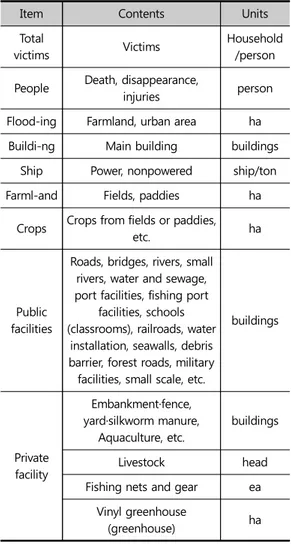
풍수해로 인한 피해는 그 규모가 점차 증가하고 있 는 추세이다. 따라서 피해를 저감하기 위한 노력의 일 환으로 피해 현황을 정확하게 조사․분석하여 정보를 구축할 필요가 있다. 이러한 피해 현황정보는 향후 풍 수해를 선제적으로 예방・대비하기 위한 중요한 자료 로 활용될 수 있을 것이다. 현재 풍수해 피해 현황 조사는 현장에 직접 인력을 투입하여 피해 시설물을 육안으로 확인하는 방법으로 진행되고 있다. 이러한 방법으로 정해진 기간 내에 광 범위한 지역을 체계적으로 조사하기에는 각 지방자치 단체 별로 인력 및 조직 운용에 한계가 있다(박성제 외 2019). 따라서 본 연구에서는 NDMS와 NSDI의 공개 자료를 대상으로, 피해조사총괄표 작성 시 활용할 수 있는 공간정보 DB 목록을 도출하고자 한다. 이를 통해 향후 데이터를 기반으로 효율적이고 정확하게 피해를 추정함으로써 풍수해 피해 현장 조사업무를 지원할 수 있는 기반을 마련할 수 있을 것이다. 풍수해 피해 조사는 「재난 및 안전관리 기본법」 제 58조 ‘재난피해 신고 및 조사’, 동법 시행령 제 67조 ‘중앙재난피해합동조사단의 구성·운영’, 동법 시행규 칙 제17조 ‘재난합동조사단의 편성 및 운영 등’의 법적 근거를 두고 있다. 풍수해로 인한 피해가 발생하면, 「자연재난 구호 및 복구 비용 부담기준 등에 관한 규정」제4조에 따른 「자 연재난조사 및 복구계획수립 요령」을 준수하여 인명 피해, 사유시설, 공공시설 등의 피해 현황을 조사하고,이를 기반으로 국가 재난․재해를 대비한 복구계획을 수립한다. 또한 피해시설물 위치, 피해 시설 유형, 강 우량(강설량), 피해 규모 등을 정확히 조사하여 피해 물량과 금액 등의 정보를 산출하여 피해상황총괄표와 재해대장에 세부 사항을 작성하여야 한다. 피해상황총괄표는 인명, 침수, 건물, 선박, 농경지, 농작물, 공공시설, 사유시설 등의 유형으로 구분되며, 각 세부 피해 조사 내용은 Table 1과 같다. NDMS는 국가와 국민의 재산·인명 피해 시 체계적 으로 대응하기 위해 행정안전부를 중심으로 정부 부 처 및 공공기관에서 관리하고 있는 재난 및 재해와 관 련된 다양한 정보를 구축한 시스템이다. NDMS에 연 계 운용되고 있는 정보는 기상, 대피소, 진화, 소방, 이 재민, 인명피해, 건축물, 문화재, 산사태, 전기, 가스, 통 신, 항공, 열차 등으로 구분할 수 있다. 풍수해 피해 조 사와 직접적으로 관련된 총 16개의 정보 중 인명피해 와 관련된 대한적십자사의 이재민 정보와 국립중앙의 료원의 의료기관 실시간 병상 정보, 구조자 병원 후송 현황 등의 속성 정보를 제외한 총 12개의 공간정보를 활용할 수 있음을 확인하였다. 정부 부처는 행정안전 부, 문화재청, 한강홍수통제소와 국립중앙의료원 등 이 있으며, 공공기관으로는 한국시설안전공단, 한국 전력공사, 한국가스안전공사, 한국원자력안전기술원 등으로 Table 2와 같이 나타났다. NDMS에서 제공하는 정보는 이재민·인명 및 공공 시설 관련 피해 현황을 살펴보기 위해 활용할 수 있지
Item Contents Units Total
victims Victims
Household /person People Death, disappearance,
injuries person Flood-ing Farmland, urban area ha Buildi-ng Main building buildings
Ship Power, nonpowered ship/ton Farml-and Fields, paddies ha
Crops Crops from fields or paddies,
etc. ha
Public facilities
Roads, bridges, rivers, small rivers, water and sewage, port facilities, fishing port
facilities, schools (classrooms), railroads, water
installation, seawalls, debris barrier, forest roads, military facilities, small scale, etc.
buildings Private facility Embankment·fence, yard·silkworm manure, Aquaculture, etc. buildings Livestock head Fishing nets and gear ea
Vinyl greenhouse
(greenhouse) ha
Table 1. Main points of the damage situation summary table
Item Provider NDMS info.
Total victims
and people
Korean Red Cross Disaster Information
National Medical Center Real-time bed information of medical institutions Medical Institution Information Master Public facilities Korea Infrastructure Safety and Technology Corporation Sewage treatment facility, water supply
information, basic facility status, river water level, gas information, underpass
information, electricity supply facility, waste
landfill information Cultural Heritage Administration Heritage Geographic Information System Ministry of the
Interior and Safety
Landslide Information System
Table 2. NDMS application plan for the damage situation summary table
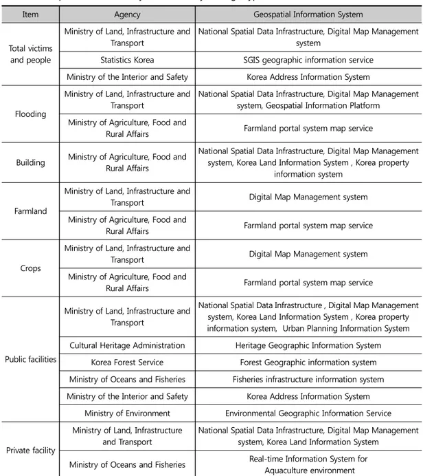
만 사유시설, 선박, 농경지 등 기타 피해 현황을 조사 및 분석하기 위한 자료로서는 한계가 존재하였다. 국토교통부의 국가공간정보센터는 매년 정부 부처, 지자체 및 공공기관을 대상으로 국가공간정보 현황을 조사하고 그 목록을 NSDI를 통해 대국민 서비스를 수 행하고 있다(국가공간정보포털, 2020). NSDI에서 제 공하는 공간정보의 분류는 ‘국토관리지역개발’, ‘도로 교통 물류’, ‘문화 체육 관광’, ‘지도’, ‘재난방재 공공안 전’, ‘환경 자연 기후’, ‘농림 해양 수산’, ‘산업 중소기 업’, ‘일반공공행정’, ‘과학기술 통신’, ‘보건의료’, ‘사 회복지’, ‘교육’ 등으로 구성되며, 풍수해로 인해 발생 가능한 인명피해, 사유 시설 피해, 공공시설 피해 등 각 세부 피해 조사 요령 및 피해 조사 항목과 매핑하여 그 적용 방안을 분석하였다. 국가공간정보포털 상 공공데이터 중에서 중앙행정 기관 12곳, 공공기관 5곳, 정부출연연구원 3곳 등 총 20곳의 관공서에서 구축한 1,611개의 공간정보 DB가 일반인에게 공개되어 있었고, 이 중 풍수해 피해 조사 와 직·간접적으로 활용할 수 있는 공간정보로는 총 8 개 기관의 193개가 도출되었다. 세부적으로 농림축산식품부 1개, 통계청 2개, 문화 재청 4개, 산림청 7개, 환경부 7개, 행정안전부 12개, 해양수산부 13개, 국토교통부 147개 등으로 나타났 다. 각 기관 별 풍수해 피해 조사 관련 운용 중인 공간 정보관리시스템은 농림축산식품부의 농지정보시스 템, 통계청의 SGIS오픈플랫폼, 문화재청의 문화재 공 간정보서비스, 산림청의 산림공간정보서비스, 환경부 의 환경공간정보서비스, 행정안전부의 국가주소정보 시스템, 국토교통부의 온나라포털, 도시계획정보체계, 국유재산관리시스템, NSDI, 국토정보시스템, 수치지 도관리시스템 등 총 8개 기관의 16개 시스템으로 조 사되었으며, Table 3과 같다. 풍수해 피해 조사와 관련된 공간정보의 약 77%는 국토교통부에서 데이터를 구축하여 관리 시스템 통해 다양한 분석 및 시각화 서비스를 제공 중임을 확인하 였다. 개별 시스템 중 풍수해 피해 조사와 관련된 가장 많은 공간정보 DB를 구축·관리하고 있는 시스템은 수 치지도관리시스템으로 조사됐으며 약 47%인 총 92개 의 공간정보 DB가 구축·관리되고 있음을 확인하였다. 이 중 NSDI의 수치지형도 1.0과 수치지형도 2.0, 국토 정보시스템의 연속지적도는 건물, 농경지, 도심, 도로, 하천, 철도, 학교, 공원, 체육용지 등 풍수해 피해 조사 항목과 관련된 다양한 공간정보를 주제도 형태로 제 공하고 있다. 피해유형별 공간정보 현황, 공간정보시스템 현황, 관리 기관 현황은 Appendix 1과 같다. 다만, 피해조사 총괄표에 작성되어야 할 피해 유형 중 공공시설 부분 의 ‘학교 교실’, ‘군 시설’, ‘소규모’ 시설과 사유 시설 부 분의 ‘가축’, ‘어망·어구’ 시설은 국가공간정보와 직‧ 간접적으로 연계가 어려워 매핑이 진행되지 않았다. NDMS는 재난 예방, 대비, 신속한 대응, 복구업무 지원 및 화재, 구조구급 등 재난 관련 정보의 대국민 서비스를 지원하는 시스템이므로, NDMS에 구축된 DB 중에서 풍수해로 인한 피해 조사와 관련된 공간정 보 DB의 현황을 조사 및 분석하였다. NSDI는 국가·공 공·민간에서 생산한 공간정보를 한 곳에서 활용할 수 있도록 구축한 국가공간정보포털로, NSDI를 비롯하 여 이와 연계된 중앙부처, 국가행정조직, 연구 기관 등 에서 구축한 공간정보 관련 시스템을 대상으로 풍수 해 관련 공간정보 DB를 조사 및 분석하였다.
5. 공간정보 품질 점검 기준 설계
본 연구에서 풍수해 피해 추정의 측면에서 활용 가 능한 공간정보의 품질 점검을 목표로 품질 점검 기준 을 다음과 같이 설계하였다. ISO 19157에서 제시하고 있는 공간정보 품질요소 관계도 중 Figure 2, Table 4와 같이 본 연구의 목적에 부합하는 완전성, 논리 일관성, 시간 품질 등 3개의 대 항목을 선정하였으며, 8개의 세부 항목을 선정하였다.각각의 항목별 점검 기준 및 방법은 Table 5와 같다. 특히, ISO 19157에서 제시하고 있는 품질 항목 중 위치정확도 항목은 풍수해 피해 추정에 있어 매우 중 요한 품질 점검 항목으로 판단되지만 위치정확도의 점검을 위해서는 직접 실측을 통해 이루어져야 한다. 본 연구의 품질 점검 기준 설계의 목적은 공간정보 DB 의 품질을 점검하여, 보다 효과적인 DB를 선택하기 위 한 대안을 주기 위함이며, 공간정보 DB 자체의 오류를
Item Agency Geospatial Information System
Total victims and people
Ministry of Land, Infrastructure and Transport
National Spatial Data Infrastructure, Digital Map Management system
Statistics Korea SGIS geographic information service Ministry of the Interior and Safety Korea Address Information System
Flooding
Ministry of Land, Infrastructure and Transport
National Spatial Data Infrastructure, Digital Map Management system, Geospatial Information Platform
Ministry of Agriculture, Food and
Rural Affairs Farmland portal system map service Building Ministry of Agriculture, Food and Rural Affairs
National Spatial Data Infrastructure, Digital Map Management system, Korea Land Information System , Korea property
information system
Farmland
Ministry of Land, Infrastructure and
Transport Digital Map Management system Ministry of Agriculture, Food and
Rural Affairs Farmland portal system map service
Crops
Ministry of Land, Infrastructure and
Transport Digital Map Management system Ministry of Agriculture, Food and
Rural Affairs Farmland portal system map service
Public facilities
Ministry of Land, Infrastructure and Transport
National Spatial Data Infrastructure , Digital Map Management system, Korea Land Information System , Korea property information system, Urban Planning Information System Cultural Heritage Administration Heritage Geographic Information System
Korea Forest Service Forest Geographic information system Ministry of Oceans and Fisheries Fisheries infrastructure information system Ministry of the Interior and Safety Korea Address Information System
Ministry of Environment Environmental Geographic Information Service
Private facility
Ministry of Land, Infrastructure and Transport
National Spatial Data Infrastructure, Digital Map Management system, Korea Land Information System
Ministry of Oceans and Fisheries Real-time Information System for Aquaculture environment
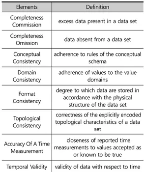
점검하고 조치하는 것은 아니다. 따라서 본 연구에서 는 위치정확도 항목은 품질 점검 항목에서 제외하 였다. 완전성 항목은 데이터셋이 기준보다 지형지물의 초 과, 누락 정도를 살펴보는 것으로 정의되며, 본 기준에 서는 지형지물의 초과, 누락 오류율을 산출하는 것으 로 설정하였다. 논리일관성 중 개념일관성 항목에서는 공간참조체 Elements Definition Completeness
Commission excess data present in a data set Completeness
Omission data absent from a data set Conceptual
Consistency adherence to rules of the conceptual schema Domain
Consistency adherence of values to the value domains Format
Consistency
degree to which data are stored in accordance with the physical
structure of the data set Topological
Consistency
correctness of the explicitly encoded topological characteristics of a data
set Accuracy Of A Time
Measurement
closeness of reported time measurements to values accepted as
or known to be true Temporal Validity validity of data with respect to time
Table 4. Definition of Data quality elements
Source: ISO Reconfiguration. 2013
Figure 2. Data quality elements of this study
Source: ISO Reconfiguration. 2013
Elements Detail elements Criterion & method Completeness
Completeness Commission 1. Number of excess data2. Ratio of excess data Completeness Omission 1. Number of absent data2. Ratio of absent data
Logical Consistency
Conceptual Consistency 1. Ratio of adherence to rules of the conceptual schema2. Ratio of non-adherence to rules of the conceptual schema Domain Consistency 1. Ratio of adherence of values to the value domains2. Ratio of non-adherence of values to the value domains
Format Consistency 1. Error ratio of physical structure
Topological Consistency
1. Number of undershoot 2. Ratio of undershoot 3. Number of overshoot 4. Ratio of overshoot 5. Number of invalid intersect 6. Ratio of invalid intersect 7. Number of invalid overlap 8. Ratio of invalid overlap
Temporal Quality
Accuracy Of A Time Measurement
1. Time accuracy at 90% significance level 2. Time accuracy at 95% significance level Temporal Validity 1. Conformity ratio of domain values2. Incompatibility ratio of domain values
계의 정확성과 데이터셋의 속성 누락 수준을 살펴보 는 것으로 설정하였다. 도메인 일관성 항목에서는 식 별자의 명확한 정의 여부를 살펴보는 것으로 설정하 였다. 형식 일관성 항목에서는 데이터가 물리적 구조 에 알맞게 저장되어 있는지를 살펴보는 것으로 상용 포맷으로 저장되어 있는지 살펴보는 것으로 설정하였 다. 위상 일관성 항목에서는 언더슛, 오버슛, 오버랩 등의 위상 관련 오류 여부를 토폴로지 규칙에 근거하 여 살펴보는 것으로 설정하였다. 시간 품질 항목은 측정시간의 참으로 알려진 값과 의 근접성과 시간과 관련된 데이터의 유효성 여부를 살펴보는 것으로 설정하였다. 본 연구에서 제시하는 품질 기준은 풍수해 피해 추 정 측면에서 활용 가능한 공간정보의 품질 점검을 목 표로 하는 것으로, 앞서 제시한 다양한 공간정보 DB 중 목적에 맞는 데이터 선택 시 의사 결정 도구로 활용 될 수 있을 것이다.
6. 결 론
최근의 풍수해는 국지적으로 발생하는 집중호우, 홍수 등의 예측이 어려운 현상이 잦아지고 있으며 유 형도 다양해지고 있다(국립재난안전연구원 2017). 국 내‧외의 다양한 연구에서 이러한 풍수해의 예측 정확 도를 향상시키기 위해 공간정보 활용의 중요성이 대 두되고 있다. 또한 고품질의 공간정보를 활용하여 풍 수해와 관련된 예측, 현황 파악, 피해 추정, 복구 계획 등의 다양한 분야에 업무 프로세스의 효율성을 향상 시킬 수 있을 것으로 판단된다. 본 연구는 풍수해로부터 발생 가능한 피해를 추정 하기 위한 공간정보 DB 활용 방안과 공간정보의 품질 점검 기준을 제안하고자 하였다. 다양한 기관에서 독 립 구축 및 관리 중인 공간정보 DB 중 풍수해 피해 추 정을 위해 활용될 수 있는 데이터를 피해유형별로 매 핑하였으며, 해당 데이터를 활용하여 피해 분석을 위 해 담보되는 품질점검 항목을 선정하여 사용자가 필 요한 데이터를 선택할 수 있도록 대안을 제안하였다. 풍수해 피해 추정과 관련된 국가공간정보 DB를 확인 하기 위해 NDMS, NSDI 공개자료 목록을 대상으로 풍 수해 피해와 관련된 공간정보 DB를 도출하였다. 풍수해 피해 조사 관련하여 직·간접적으로 총 20곳 의 관공서에서 구축한 공간정보 항목은 1,611개가 확 인되었으며, 직·간접적으로 피해조사에 활용할 수 있 는 공간정보는 총 8개 기관의 193개 공간정보 DB가 도출되었다. 풍수해 피해 추정 관련 공간정보 품질 점검 기준은 ISO 19157(데이터 품질)을 기반으로 제안되었으며, 본 연구의 목적에 부합하는 완전성, 논리 일관성, 시간 품질 등 3개의 대항목을 선정하였으며, 8개의 세부 항 목을 선정하였다. 본 연구를 통해 풍수해 피해 추정 관련 기관의 종사 자 및 연구자는 보다 쉽게 관련 공간정보 DB 항목 도 출을 통해 이를 바탕으로 활용이 가능할 것이며, 품질 점검 기준을 통해 분석 결과의 신뢰성을 담보할 수 있 을 것이다. 본 연구 결과를 바탕으로 풍수해 피해 추정 에 있어 공간정보 DB의 활용성이 증대될 것으로 판단 되며, 이를 통해 효율적인 풍수해 피해 관리 체계의 기 반의 마련될 것으로 기대한다. 또한 HAZUS-MH와 같은 시스템으로 재해의 피해를 예측하기도 하지만, 최근에는 인문사회적인 접근으로 거주민들의 수득 수 준이나 교육수준, 인프라 구축 정도 등을 고려하여 취 약지를 선정하기 위한 지표를 개발하는 연구가 진행 되고 있다(Cutter et al. 2003; Flanagan et al. 2011). 이러한 지표는 자연재해뿐만 아니라 현재 전세계적으 로 확산되고 있는 코로나19와 같은 전염병에도 적용 될 수 있다(Kang et al. 2020). 따라서 본 연구와 같이 기관별로 구축된 공간정보를 활용할 분야에 맞게 매 핑하고, 품질을 확보할 수 있는 기준을 마련한다면, 각 종 재해 또는 보건 및 질병 예방을 위한 목적으로도 활 용될 수 있을 것이다.주1. FEMA’s National Flood Hazard Map http://msc.fema.gov/nfhl
주2. Calgary's River Flood Story
https://maps.calgary.ca/RiverFlooding/
주3. Australian Flood Risk Information Portal Source: http://afrip.ga.gov.au/flood-study-web/#/search
참고문헌
References
강병기, 김재문. 2011. 지적정보 품질과 서비스 품질 평가에 관한 연구. 부동산경영. 4:115-134. Kang BG, Kim JM. 2011. A Study on the Quality
Evaluation of Cadastral Information and Service. Journal of the Korea Real Estate Management Review. 4:115-134.
강수영, 김광희, 김동춘, 유해수, 민동주, 석봉출. 2007. 지진재해예측을 위한 HAZUS와 Shake Map의 한반도에서의 적용가능성 연구. 한국지리정보학 회지. 10(1): 47-59.
Kang SY, Kim KH, Kind DC, Yoo HS, Min DJ, Suk BC. 2007. A Preliminary Study of the Global Application of HAZUS and Shake Map for Loss Estimation from a Scenario Earthquake in Korean Peninsula. Journal of the Korean Asso-ciation of Geographic Information Studies. 10(1): 47-59.
강익범, 박정호. 2002. HAZUS를 이용한 충남지역의 지진피해 연구. 한국방재학회지. 2(2): 73-83. Kang IB, Park JH. 2002. The Seismic Hazard Study
on Chung-Nam Province using HAZUS. Journal of Disaster Management. 2(2): 73-83.
고재용, 김영욱, 김은형. 2017, 기존 기술기준의 공간 정보 표준 적용연구. 지적과 국토정보 47(2): 121-133.
Ko JY, Kim YW, Kim EH. 2017. A Study on the
Application of Spatial Information Standards to Existing Technical Regulations. Journal of Cadastre & Land InformatiX. 47(2): 121-133. 김봉준, 김태영. 2011. 지적정보 품질진단을 취한 측정
요인 개발연구. 한국지적학회지. 27(2): 139-149. Kim BJ, Kim TY. 2011. Measurement Element
Development Research for Cadastral Infor-mation Quality Diagnosis. Journal of the Korean Society of Cadastre. 27(2):139-149.
국립재난안전연구원. 2017. 풍수해저감종합계획시스 템개발 Ⅱ.
National Disaster Management Research Institute. 2017. Development of flood mitigation planning system Ⅱ.
국토교통부. 2017. 국가공간정보 표준화 연구. Ministry of Land, Infrastructure and Transport.
2017. Research for National Spatial Information Standardization.
박성제, 김민숙, 서예진, & 박계영. (2019). 풍수해 피 해예측을 위한 피해조사 방법 개선. 한국방재학 회. 19(6): 247-252.
Park, SJ, Kim MS, Seo YJ, Park KY. 2019. Analyzing Damage Investigation Method for Storm and Flood Damage Prediction: Focus on Increa-sing Accuracy. Journal of the Korean Society of Hazard Mitigation. 19(6): 247-252.
서강현, 황의호, 백승협, 임소망, 채효석.2017. 풍수해 피해예측지도 연계·활용을 위한 표준 메타데이 터 설계. 한국지리정보학회지. 20(3):52-66. Seo KH, Hwang EH, Baeck SH, Lim SM, Chae HS.
2017. Standard Metadata Design for Linkage and Utilization of Damage Prediction Maps. Journal of the Korean Association of Geographic Information Studies. 20(3):52-66.
영역에서의 HAZUS 기반 지진피해 추정. 한국지 리정보학회지. 17(4): 10-27.
Sun CG, Chun SH. 2014. Preliminary Estimation of Earthquake Losses Based on HAZUS in a Coastal Facility Area with Blocks Applying Site Classification. Journal of the Korean Association of Geographic Information Studies. 17(4): 10-27.
심규성. 2016. 침수지도 수집 및 관리를 위한 벡터형 공간정보 표준 기반의 메타데이터 설계. 한국산 학기술학회논문지. 17(5):42-48.
Sim GS. 2016. Metadata Design Based on Vector Type Geospatial Information Standard for the Collection and Mana- gement of Inundation Map. Journal of the Korea Academia-Industrial cooperation Society. 17(5):42-48.
이보미. 2019. 국가공간정보 유통 활성화를 위한 공간 데이터 품질평가 방안 연구. 박사학위논문. 경희 대학교.
Lee BM. 2019. A Study on the Quality Evaluation of Spatial Data to Improve the Usability of National Geospatial Information [disserta- tion]. Kyung Hee University.
이상원. 2018. HAZUS-MH 허리케인 모델을 활용한 한반도 침수 피해 추정. 석사학위논문. 경희대 학교.
Lee SW. 2018. Estimation of Typhoon Damage on the Korean Peninsula Using the HAZUS-MH Hurricane Model [thesis]. Kyung Hee University. 이용호. 2018. ISO 품질표준 기반의 지적정보 품질평 가 개선방안 연구. 한국지적학회지. 34(1): 69-76.
Lee YH. 2018. A Study on Improvement of the Cadastral Information the based on the ISO Quality Standards. Journal of the Korean
Society of Cadastre. 34(1): 69-76.
전방진. 2013. 지적정보를 위한 품질 표준화 적용방안 에 관한 연구. 한국지적정보학회지. 15(1): 213- 225.
Jeon BJ. 2013. A Study on the Quality Standar-dization Method For High Quality of Cadastral Information. Journal of The Korean Cadastre Information Association. 15(1):213 -225. 지종덕. 2013. 우리나라 지적정보의 발전 방향에 관한
연구. 지적과 국토정보. 43(1): 1-22.
Ji JD. 2013. A Study on the Development Direction of Korea Cadastral Information. Journal of Cadastre & Land InformatiX. 43(1): 1-22. 최재연・김은형. 2020. 사용자 관점의 융․복합 공간정
보 품질관리 방안 연구. 지적과 국토정보. 50(1):47-62.
Choi JY, Kim EH. 2020. A Quality Management Model for Consumer-oriented Spatial Informa-tion. Journal of Cadastre & Land InformatiX. 50(1):47-62.
현수현, 김학열. 2017. 풍수해 사회경제적 직‧간접손 실 통계항목 선정에 관한 연구. 한국방재학회지. 17(2):349-359.
Hyun SH, Kim HY. 2017. Selecting Indices of th Direct and Indirect Socio-Economic Losses from Storm and Flood. Journal of the Korean Society of Hazard Mitigation. 17(2):349- 359. Cutter, S.L., Boruff, B. J., Shirley, W. L. 2003. Social
vulnerability to environmental hazards. Social science quarterly, 84(2):242-261.
Flanagan, B. E., Gregory, E. W., Hallisey, E. J., Heitgerd, J. L., Lewis, B. 2011. A social vulnerability index for disaster management. Journal of homeland security and emergency management, 8(1).
ISO. 2013. ISO 19157 Geographic information — Data quality.
Kang, J. Y., Michels, A., Lyu, F., Wang, S., Agbodo, N., Freeman, V. L., Wang, S. 2020. Rapidly measuring spatial accessibility of COVID-19 healthcare resources: a case study of Illinois, USA. International Journal of Health Geographics, 19, 36.
Lowther J.L. 2008. Application of the Hazus-MH Risk. Assessment Tool in Planning for Continuity of Operations. [thesis]. Arkansas Tech Univer-sity.
국가공간정보포털. 2020. 공간정보목록. [인터넷]. [http://www.nsdi.go.kr/]. 2020년 9월 5일 검색 National Spatial Infrastructure Portal. Spatial
information list. 2020. [Internet]. [http:// www.nsdi.go.kr/]. Last accessed 5 Sep 2020. 국민재난안전포털. 2020. 재해정보지도[인터넷].
[http://www.safekorea.go.kr/idsiSFK/neo/sf k/cs/sfc/map/disasterMapMain.jsp?menuSeq =714]. 2020년 9월 24일 검색.
Safekorea. 2020. Disaster Information Map [Internet]. [http://www.safekorea.go.kr/idsiSFK/ neo/sfk/cs/sfc/map/disasterMapMain.jsp? menuSeq=714]. Last accessed 24 Sep 2020.
풍수해 보험관리지도 통합관리 시스템. 2020. 풍수해 보험요율 찾아보기[인터넷]. [http://www. sfim.go.kr/sfim/insuranceFindRateMap.do]. 2020년 9월 24일 검색.
Storm and Flood Insurance map Management system. 2020. Search for Storm and Flood Insurance Rate[Internet]. [http://www. sfim.go.kr/ sfim/insuranceFindRateMap.do]. Last accessed 24 Sep 2020.
(FEMA) Federal Emergency Management Agency. 2020. FEMA’s National Flood Hazard Map [Internet]. [http://msc.fema.gov/nfhl]. Last accessed 25 Sep 2020.
Geoscience Australia. 2020. Australian Flood Risk Information Portal[Internet]. [http://afrip. ga.gov.au/flood-study-web/#/search]. Last accessed 24 Sep 2020.
The City of Calgary. 2020. Calgary's River Flood Story[Internet]. [http://maps.calgary.ca/river flooding/]. Last accessed 24 Sep 2020.
2020년 10월 03일 원고접수(Received) 2020년 10월 08일 1차심사(1st Reviewed) 2020년 11월 25일 게재확정(Accepted) 초 록 본 연구는 풍수해로부터 발생 가능한 피해를 추정하기 위한 공간정보 DB 활용 방안과 공간정보의 품질 점검 기준을 제안하고자 하였다. 국가재난관리정보시스템, 국가공간정보통합체계 공개자료 목 록을 대상으로 공간정보 DB 중 풍수해 피해 추정을 위해 활용될 수 있는 데이터를 피해유형별로 매 핑하였으며, 해당 데이터를 활용하여 피해 분석을 위한 품질 점검 기준 항목을 제안하였다. 본 연구를 통해 풍수해 피해 추정을 위한 공간정보 DB 활용이 가능할 것이며, 품질 점검 기준을 통 해 분석 결과의 신뢰성을 담보할 수 있을 것이다. 주요어 : 풍수해 피해, 피해 추정, 공간정보 데이터 품질, 재난 정보
Item Agency Geospatial Information System Data list Total victims Ministry of Land,
Infrastructure and Transport
National Spatial Data
Infrastructure Administrative district’s boundary
People Death, disappearance, injuries
Digital Map Management
system Eup
Statistics Korea information serviceSGIS geographic Administrative district’s boundary Census Output Areas boundary, Ministry of the Interior and Safety Korea Address Information System Administrative District Ri / Si-Gun-Gu / Si-Do / Eup-Myeon-Dong Flooding Farmland Digital Map Management system Geospatial Information Platform Farmland/Agricultural Promotion Area Ministry of Agriculture, Food
and Rural Affairs
Farmland portal system
map service Farmland Diversion Status Map
Urban area
Ministry of Land, Infrastructure and
Transport
National Spatial Data
Infrastructure Urbanization zone boundary Geospatial Information
Platform
City/other use area district, Land planning/urban area Digital map management
system Group house boundary
Building buildingMain
Washed away · total destruction Ministry of Land, Infrastructure and Transport
National Spatial Data Infrastructure
Road name address building, building, building group Korea property
information system Building Geospatial Information
Platform
Building Integrated Information_Master Digital map management
system
Non-housing buildings, buildings, temporary buildings, (building
boundary) unclassified
Farmland Fields
Ministry of Land, Infrastructure and
Transport
Digital map management
system Field
Ministry of Agriculture, Food
and Rural Affairs
Farmland portal system
map service Farmland Diversion Status Map
Item Agency Geospatial Information System Data list
Paddies
Ministry of Land, Infrastructure and
Transport
Digital map management
system Paddies
Ministry of Agriculture, Food
and Rural Affairs
Farmland portal system
map service Farmland Diversion Status Map
Crops
Crops from fields
Ministry of Land, Infrastructure and
Transport
Digital map management
system Field
Ministry of Agriculture, Food
and Rural Affairs
Farmland portal system
map service Farmland Diversion Status Map
Crops from paddies
Ministry of Land, Infrastructure and
Transport
Digital map management
system Paddies
Ministry of Agriculture, Food
and Rural Affairs
Farmland portal system
map service Farmland Diversion Status Map
etc.
Ministry of Land, Infrastructure and
Transport
Digital map management
system Orchard
Public
facilities Roads Roads
Ministry of Land, Infrastructure and
Transport
National Spatial Data Infrastructure
Road boundary_myeon, road (status), (road name address) real
width road, (road name address) road section
Geospatial Information Platform
Road/Usage Zone, High-speed National Highway/Adjoining Zone Urban Planning
Information System
Road (Status), Other Infrastructure (Status), Public Pedestrian
Pathway (Status)
Digital map management system
Bicycle roads, lanes, road boundaries (myeon), elevated
sections (road facilities), (rail bridge) unclassified, (railbridge) overpass sections, (existing roads)
metropolitan and metropolitan roads, (existing roads) local roads,
(existing roads) general National Road, (Existing Road) City Road,
Item Agency Geospatial Information System Data list
(Existing Road) Myeonri Road, (Existing Road) Islands, (Existing
Road) Highway Ministry of the Interior and Safety Korea Address Information System
Overpass, road section, real width road
Bridges
Ministry of Land, Infrastructure and
Transport
National Spatial Data
Infrastructure Bridges Digital map management
system
Bridge, (Bridge) Concrete Bridge, (Bridge) Unclassified, (Bridge) Wooden Bridge, (Bridge) Steel
Bridge Ministry of the
Interior and Safety
Korea Address
Information System Bridges
Rivers
Rivers
Ministry of Land, Infrastructure and
Transport
National Spatial Data Infrastructure
River center line, retaining wall, river boundary, real width river,
levee Korea property
information system River Geospatial Information
Platform River Network, River/Use Zone
Digital map management system
Dirt embankment (bottom), Dirt embankment (top), river center line, river boundary, retaining wall,
(bank) unclassified, symbolic embankment, water boundary
(river), real width river, embankment Ministry of the
Interior and Safety
Korea Address
Information System River/Lake
Small rivers
Ministry of Land, Infrastructure and
Transport
National Spatial Data
Infrastructure Retaining wall Geospatial Information
Platform Small river/small river area Digital map management
Item Agency Geospatial Information System Data list Water supply Water and sewage Ministry of Land, Infrastructure and Transport Geospatial Information
Platform Sewer/Drainage Area Digital map management
system Water level station
Ministry of Environment
Environmental Geographic Information
Service
Designated waste (workplace), designated waste (medical),
sewage treatment facility, livestock manure generation and
public treatment facility treatment, general waste generation and treatment,
regional household waste treatment method Port facilities Port facilities Ministry of Land, Infrastructure and Transport
National Spatial Data
Infrastructure Wharf Korea property
information system Port Geospatial Information
Platform
Port/Zoning area Port and its surrounding area/port
redevelopment project area Digital map management
system
Pier, breakwater (bottom), breakwater (top) Fishing port facilities Fishing port facilities Ministry of Land, Infrastructure and Transport
Digital map management system
Breakwater (bottom), breakwater (top) Ministry of Oceans and Fisheries Fisheries infrastructure information system
Fishing port development plan, fishing port area map, and status of permission to use and occupy
fishing port facilities Schools Classrooms
Rail
roads Rail roads
Ministry of Land, Infrastructure and
Transport
National Spatial Data Infrastructure
Railroad center line, railroad border
Korea property
information system Railroad Geospatial Information
Platform
Railroad Safety/Use Area, Railroad/Railroad Line Adjacent
Item Agency Geospatial Information System Data list
Digital map management system
Railroad tunnel, railroad center line_v2.0, railroad center line,
railroad border, railroad, rail bridge, railroad tunnel, railroad
centerline_v2.0, railroad center line, railroad border, railroad, iron
bridge (real width track) special railroad, (real width track) Railroad in tunnel, (real width track) normal
railroad Ministry of the
Interior and Safety
Korea Address
Information System Railroad tracks/Railroad station
Water install-ation Water installation Ministry of Land, Infrastructure and Transport Geospatial Information Platform
Reservoir and dam safety/maintenance district Digital map management
system
Lake/reservoir, pumping station, drainage lock gate, drainage
station, beam, sluice gate, pumping station Breakwater
Ministry of Land, Infrastructure and
Transport
Digital map management system
Earthen seawall (bottom), Earthen seawall (top), seawall
Debris barrier Debris barrier Ministry of Land, Infrastructure and Transport Geospatial Information
Platform Debris barrier project area Korea Forest
Service
Forest Geographic
information system Check dam Forest
roads
Korea Forest Service
Forest Geographic
information system Hiking trails
Military facilities -Small scale Etc. Industrial complex Ministry of Land, Infrastructure and Transport
Digital map management
system National Industrial Complex
Park
Ministry of the Interior and
Safety
Korea Address
Information System Park Ministry of Environmental National Park
Item Agency Geospatial Information System Data list Environment Geographic Information Service
Governme nt office
Ministry of Land, Infrastructure and
Transport
Digital map management system
Community center, town office, post office, city hall, village office,
provincial office, other government offices Cultural Heritage Ministry of Land, Infrastructure and Transport
National Spatial Data Infrastructure
Cultural Property Geographic Information_Registered Cultural
Property, Cultural Property Geographic Information_National
Designated Cultural Property, Cultural Property Digital map management
system
Cultural Property Protection Area, Cultural Property, Scenic Site
Cultural Heritage Administration
Heritage Geographic Information System
Nationally-designated cultural property protection zone, nationally-designated cultural
property-designated area, city-city-designated cultural property protection area, and
city-city-designated cultural property-designated area Disaster Prevention Ministry of Land, Infrastructure and Transport
National Spatial Data
Infrastructure Disaster Prevention Facility Urban Planning
Information System Disaster Prevention Facility
Landslide Korea Forest Service Landslide Information System
Recreational Forest Arboretum, Recreational Forest Notice Area Map, Landslide Area, Landslide
Road Area Sports facilities Ministry of Land, Infrastructure and Transport
National Spatial Data
Infrastructure Public·cultural sports facility Ministry of Land,
Infrastructure and Transport
Geospatial Information
Platform Public·Cultural Sports Facility Ministry of Land,
Infrastructure and Transport
Urban Planning
Item Agency Geospatial Information System Data list Private facility Embankment·fence Ministry of Land, Infrastructure and Transport
Digital map management system
Dirt fence, hedge fence, plank wall, fence Livestock -Yard·silkworm manure Ministry of Land, Infrastructure and Transport
National Spatial Data
Infrastructure Livestock protected area Ministry of Land,
Infrastructure and Transport
Digital map management
system Yard
Aquaculture
Ministry of Land, Infrastructure and
Transport
National Spatial Data
Infrastructure Aquaculture Farm Ministry of Land,
Infrastructure and Transport
Digital map management system
Fish farm, aquaculture farm boundary, aquaculture farm Ministry of Oceans and Fisheries Real-time Information System for Aquaculture environment
Fishing grounds, investigation peak_inland water surface, survey peak_sea level, facility information
(aquaculture),
Fishing nets and gear
-Vinyl greenhouse (greenhouse)
Ministry of Land, Infrastructure and
Transport
Digital map management