A Preliminary Geomorphic Overview of Late Quaternary Glacier Fluctuations in the South Shetland Islands, West Antarctica
Yeong Bae Seong
1, Hyoun Soo Lim
2, Ho Il Yoon
2, Yong Il Lee
3, Yeadong Kim
2, Lewis A. Owen
1서남극 남쉐틀랜드 군도의 제4기 후기 빙하 활동의 지형학적 고찰
성영배
1, 임현수
2, 윤호일
2, 이용일
3, 김예동
2, Lewis A. Owen
1Abstract:The timing and extent of glaciations during the Late Quaternary in the South Shetland Islands, West Antarctica were defined using field mapping, geomorphic analysis and radiocarbon dating. Landforms of glacial erosion and deposition, in particular subglacial meltwater channel erosion, suggest that at least three glaciations occurred during the late Quaternary within the study region. During the global LGM, glacial troughs (such as Maxwell Bay and Admiralty Bay) were overdeepened by an ice stream moving south from an~1000m-thick ice cap centered on the present-day continental shelf to the north. This ice was responsible for the subglacial meltwater channel erosion, and glacial polished and striated bedrock on the Fildes Peninsula. The recent local glaciations occurred about 2,000 years ago and during Little Ice Age (LIA). During these glaciations, glaciers were less extensive than the previous one and less erosive as a cold-based ice.
Key Words : West Antarctica, South Shetland Islands, Late Quaternary, glacier, subglacial meltwater channel, moraine, striation, equilibrium line altitude.
요약:2005~2006 남반구 여름기간 동안 서남극 남쉐틀랜드 군도의 빙하지형 및 그에 관련된 제 4기 후기 기후변화에 대하여 조사 했다. 빙하지형학적 증거와 방사성탄소 연대측정 결과는 이 지역에서 세 번 이상의 빙하 전전이 있었음을 보여준다. 첫번째는 광범 위한 빙하활동으로서 최종빙기 최성기(LGM)에 형성된 것으로 보이며 해저지형과 빙하기저 융빙수 하천, 그리고 찰흔의 기록에 의 하면 빙상의 중심이 지금의 북쪽 대륙붕에 있었고 약 1000m의 두께와 바닥면의 온도가 어는점 이상이었던 것으로 추측된다. 이와 는 달리 홀로세 후기에도 최소 두 번 이상의 빙하 전진이 있었는데 이들은 현재의 해안선을 넘지 못하는 매우 제한된 범위였고 빙하 의 기저면이 어는점 이하에 있어서 침식활동이 미약했던 것으로 판단된다. 이들 제한된 빙하활동은 약 2천년전 그리고 소빙기에 각 각 발생하였다.
주요어 : 서남극 남쉐틀랜드 군도, 제 4기 후기, 빙하기저 융빙수 하천, 빙퇴석, 찰흔, 빙하평형 고도.
1Department of Geology, University of Cincinnati, Ohio 45221-0013, USA, [email protected]
2Korea Polar Research Institute, Incheon 406-840, Korea
3School of Earth and Environmental Sciences, Seoul National University, Seoul 151-747, Korea
1. Introduction
Knowledge of the past configurations and behavior of the Antarctic ice sheets are necessary to calibrate glaciological models that attempt to predict future responses of the ice sheets and to quantify their contribution to eustatic sea level rise during the last deglaciation (Ackert et al., 1999). Over the past decades, studies on long term climate changes in Antarctica have been centered on ice core and marine records, which have provided important insights into atmosphere-oceanic coupling during the last glacial cycle. Owing to the lack of large ice-free areas and the presence of permafrost, terrestrial records have played a less significant role in documenting past climate change. However, significant evidence for past
glacier oscillations exist in the terrestrial record on the coasts of the Antarctic Peninsula and on the sub-Antarctic islands of the Scotia Sea, such as the South Shetland Islands (SSI), which are beyond the present northern limits of West Antarctic Ice Sheet (WAIS). The terrestrial record can help answer many questions, which include the following. How extensive were the glaciers in the sub-Antarctic islands during the global Last Glacial Maximum (LGM)? When glaciers begin to retreat during the global LGM and the Holocene? Were the glaciers temperate or polar-based? The aim of the study is to provide a synthesis of available information and to present new data and interpretations from the fieldwork undertaken during the Austral summer of 2005-2006 that shed light on these questions.
Figure 1. Locations of study area. (A) South Shetland Islands in Antarctica. (B) Mean annual temperature from 1968 to 2003 (Lagun and Jagovkina, 2004). (C) King George Island and its glacial drainage-basin divides (after Simoes et al., 1999). FP stands for Fildes Peninsula, WP for Weaver Peninsula, BP for Barton Peninsula.
Weather station for (B) is shown as filled triangle (▲). Light-gray colored area represents ice free area.
2. Study Area
The South Shetland Islands (SSI) is situated on the southern flank of Drake Strait, 140 km distant from the tip of the Antarctic Peninsula (Fig. 1).
The SSI consists of eleven major and hundreds of minor islands and shoals, stretching northeastwards for over 230 km. The SSI is a magmatic island arc and its geological evolution is closely linked to the formation of the Antarctic Peninsula (Smellie et al., 1984). King George Island is the largest of the SSI and is situated in the middle of the arc.
The climate of cold oceanic type, characteristic of maritime Antarctica, with frequent summer rains and has moderate annual thermal amplitude (Turner et al., 1998). The mean annual temperature of the King George Island has been rapidly rising owing to global warming, fluctuating between -1℃and -4℃(Fig. 1B; Lagun and Jagovkina, 2004). Cyclonic activity is higher in summer as a consequence of the shift of the circum-Antarctic low pressure trough, bringing high precipitation to the archipelago (Turner et al., 2004). During winter, high pressure in the region of the Antarctic Peninsula is commonly associated with cold air temperatures on King George Island. In contrast, during the summer, northerly and north-westerly advection leads to moist and warm air masses to the SSI (King and Turner, 1997).
3. Glaciers and Glacial History
The island chain is heavily glaciated, with relatively few ice-free areas. The climatic conditions prevailing in the SSI permit the development of an ice cap covering practically the whole archipelago that reaches the coastline
to form the vertical ice cliffs up to about 40 m high. The firn limit increases progressively in height northward along the archipelago, attaining its maximum at King George Island.
Glaciers tend to terminate at the shore. Their extent is likely controlled largely by sea level and wave erosion at the base of the glacier cliff (Fig. 1C).
Two major Pleistocene glaciations have been recognized based on the raised marine landforms that include erosional platforms and raised beach deposits, and on the relationships between those and the glacial landforms (Everett, 1971; John and Sudgen 1971; Birkenmajer, 1981; Leventer et al., 1996 ; Hjort et al., 1998; Hall, 2003; Yoo et al., 2006). Troughs cut into the submarine shelves by ice streams or outlet glaciers, and ice-scoured features on the shelf areas suggest that the ice caps were warm-based (Sugden and John, 1973).
Curl (1980) argued that the South Shetland marine interval left beach sediments on the terrace as high as 200 m above the present sea level, predated the last glaciation. This may be equated with the Last Interglacial and suggests that the collapse of the maximum SSI ice cap took place during warming associated with the developing Last Interglacial and/or the collapse of the Western Antarctic Ice Sheet (WAIS). The subsequent glaciation in the SSI was thought to span the whole of the last glacial cycle.
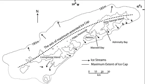
The ice cap during the last glacial cycle, covered both King George and Livingston islands and reached the offshore platform to the north and west (Fig. 2). Evidence, such as the alignment of glacial troughs, roches moutonnees, striations, and meltwater channels, led John and Sudgen (1971) to the conclusion that the axis of the former ice cap had been aligned along the northern coastline of the islands and not along
the present mountain crests. The following minor glaciation during the Holocene was much more restricted, extending no farther than the coastal peninsulas (Björck et al., 1991). This suggestion is based on evidence that includes till clast fabrics, the distribution of erratics, and shoreline landforms and sediments.
4. Equilibrium line altitude (ELA)
Comparisons between former and present equilibrium-line altitudes (ELAs) have yielded valuable information on the magnitude and extent of climatic change in glaciated areas (Porter, 1975; Meirding, 1982; Ohmura et al., 1992; Benn et al., 2005). The ELA of the Marian Cove Glacier (Fig. 1), which is the glacier associated with the dating undertaken in our
study was therefore determined to help quantify past and present glacial conditions using accumulation-area ratio (AAR) of 0.6 (Fig. 5;
Table 1). The AAR method, however, does not recognize the potential effect of glacier hypsometry as a possible source of error. Thus, Furbish and Andrews (1984) developed an ablation-accumulation balance ratio (BR) method that takes into account glacier hypsometry. This method was successfully applied to the glaciers
Figure 2. A reconstruction of the ice cap at the Last Glacial Maximum (LGM), based on erosional landforms.
The seaward limits of the ice cap are assumed to have been determined by the 100 m fathom (185 m depth in water) line (after John and Sugden, 1971)
Table 1. Area and equilibrium-line altitudes (ELAs) of Marian Cove glacier. (AAR=accumulation-area ratio, BR=ablation-accumulation balance ratio).
Area (km2) AAR= 0.6(m) BR = 2 (m)
Present 20.1 279 292
2,000 yr. BP 23.3 258 274
ΔELA 21 18
in the Arctic and Tibet (Ballantyne, 2002; Owen and Benn, 2005). The geometric calculations for ELA reconstruction were made using a 200 m resolution RADARSAT DEM (Radarsat Antarctic Mapping Project Digital Elevation Model Version 2). Glacial landforms were identified in the field with the help of a geomorphic map published by Korean Polar Research Institute (Lopez-Martinez, et al., 2002).
5. Moraines and their chronology
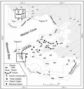
In the outer part of Barton Peninsula, an articulate moraine ridge can be traced along the northeastern and southwestern side of the peninsula, rising 20-30m high above the present beach (Fig. 4). The ridge is covered by a bouldery deposit, consisting mostly of pebbles and cobbles. It is > 60 m wide and is 5~8 m high, and its steepest side slopes 40-50°towards the beach. It exhibits a typical latero-frontal moraine form and is likely an ice-cored moraine (Fig. 6). Three organic samples collected from the boundary moss layer between dead-ice and moraine sediment were dated using conventional radiocarbon techniques at Geochron Laboratories, USA (Fig. 6; Table 2). The moss was identified in the field as terrestrial and it compares favorably to living species on rocks above the present
beach. The inversion of ages supports the view that ice in the moraine was buried by meltout till and that the till was subsequently inverted by slumping during meltout. The ice was unlikely to have formed by in-situ growth, such as is the case for the pingos. This moraine was probably produced by one of glacier advances that occurred during the late Holocene. Another moraine ridge is present on the Weaver Peninsula (Figs. 4 and 7F). This is located ~10m away from the contemporary snout of glacier. It is 4-7m high, consisting mainly of angular boulders ranging between 20~60 cm in diameter.
This moraine is interpreted as a lateral moraine formed by a glacier that advanced during the Little Ice Age (LIA) or more recently.
6. Results and discussion
1) Earlier extensive glaciation
The most spectacular features of the SSI are its straits. These are cut as deeply as 500 m into the island group, including, for example, Maxwell Bay, Admiralty Bay, and Collins Harbour (Figs. 1 and 2). The deep troughs stand out in topographic contrast with the flat continental shelf. The origin of the source of the ice that cut the Maxwell Bay trough is problematic. Unlike Table 2. Radiocarbon ages of moss and peat samples collected from the ice-cored moraine in the Barton Peninsula, King George Island.
No Lab. Code Area Material δ13C 14C Age
(‰) (yr. BP)
BPS-1 060129-1 Ice-cored moraine Terrestrial moss -25.5 1,860 ±80
BPS-2 060129-2 Ice-cored moraine Peat -22.8 2,180 ±70
BPS-3 060129-3 Ice-cored moraine Terrestrial moss -23.7 1,530 ±60
other troughs, which were clearly carved by ice streams nourished by ice caps that remain until today, the ice to erode the Maxwell Bay trough could not have been derived entirely from the narrow arc of land around trough head, since the Fildes Peninsula and Nelson Island is not extensive enough or high enough to have supported an active ice dome. The longitudinal profile for Maxwell Bay trough show characteristic overdeepening and it has prominent sills near its mouths. It is similar to fjords such as those present elsewhere in Antarctica (Choi et al., 1990;
Domack and Ishman, 1993; Yoon et al., 1997).
Therefore, we suggest that the ice cap that supplied the Maxwell Bay glacier must have been grounded to the northwest (the present-day continental shelf) of the islands (John and
Sugden, 1971; Fig 2).
This view is supported by field evidence.
Firstly, the bedrock channel pattern on the ice- free area of on Fildes Peninsula (Fig. 3) makes this view more convincing because, most of the channels are not related to contemporary subaerial channel downcutting. The only exception is a small stream running from the Collins ice cap straight to the ocean. Hence, the meltwater channels are thought to be a relict landforms relating to a former ice cap. Several channels have their origins on the western side of the watershed and cross cols through humped sections that rise ~9m (Fig. 7A). They then split up into complex anastomosing systems, which have individual channels up to 15 m deep, with flat floors and occasional cliffs. In contrast, the channels on the north of Fildes Peninsula have single channels, resulting from more erosion due to thicker and more erosive glacier ice. Therefore it is logical to conclude that the erosive agent was subglacial meltwater, flowing generally Figure 3. Geomorphic map of the Fildes Peninsula.
Bedrock channels carved by subglacial meltwater were redrawn from John and Sugden (1971).
Figure 4. Geomorphic map of the Barton and Weaver Peninsulas (after Lopez-Martinez et al., 2002).
southeastward across the watershed, under the influence of a strong ice gradient in the same direction created the landscape. Comparable erosional forms occur also on Barton Peninsula (Fig. 4). U-shaped valleys (Fig. 7D), ice moulded surfaces, such as rock drumlins and roches moutonnees (Fig. 7E), are present below the snout of the present ice cap.
The view that an extended ice cap grounded on the northern continental shelf is supported by other field evidence. This includes two perpendicular striation directions related to former glacier flows (Figs. 3 and Fig. 7B).
Striations with different directions could have also formed by a single ice source with a changing ice divide. However, the present
topography is probably too low and ice thickness is too thin to support changing ice divides and changing ice flow directions. The older ice flow direction was north-south, possibly resulting from ice centered on the present-day continental shelf, parallel to the ice source that carved the deep Maxwell Bay. Meanwhile, younger striations Figure 5. Area-altitude distribution (Hypsometry) of
Marian Cove Glacier for ~2000 years ago (A) and the present (B).
Figure 6. Ice-cored moraine at Barton Peninsula and locations of samples for AMS radiocarbon dating. (A) Exposure of ice-cored moraine at Barton Peninsula and (B) its interpretation. Lithofacies code is as follows. Dmm - matrix-supported, massive diamict. Dms - matrix-supported, stratified diamict.
Dmm(s) - matrix-supported, massive diamict with sand unit. (C) Development of ice-cored moraine by ice ablation and backwasting.
were marked by an east-west advance from the present-day Collins Ice Cap.
The timing of a former extensive ice cover extending well north of the present continental shelf is not defined. This is because of the lack of dateable material. Given the oldest age (~17,000 years ago) of deglaciation from sediments on the
continental shelf and Maxwell Bay (Pudsey et al., 1994; Yoon et al., 2006), it is likely that this ice cap expanded during the global Last Glacial Maximum (LGM).
2) Local glacier advances during the Holocene
Ice-free areas which are not covered with beaches or scree and are generally strewn with erratic blocks and till, reflecting recent glacier advances in the SSI. On the Barton Peninsula, erratics of fine-grained igneous rock are present on volcanic bedrock. With the exception of the present outlet glacier margin, few moraine ridges were observed below the ice edge. One exception is the area around the King Sejong Station at ~10m above sea level. Here multiple lines of latero-frontal moraine ridges are present (Figs. 4, 6 and 7C). These moraines formed during an ice readvance and remain intact because of unmelted ice beneath their surface (Fig. 6). Two layers of terrestrial moss were found and collected for radiocarbon dating within the sediments that comprise these landforms. The fact that the moss from the upper layer yielded an older age (stratigraphic inversion) implies that these deposits were formed by in situ ice decay, causing slumping of the debris and inversion of the stratigraphy. This advance was possibly contemporaneous with the event that carved the younger striations on the Fildes Peninsula. The view that the dead ice within the moraine is a relict of a glacier that advanced to the sea level, is supported by Hochschild (1995). He reported that the moraines on the Potter Peninsula are all ice-cored and that δ18O and δD values in the ice were from the same as of the recent glacier ice. This may be Figure 7. Views of glacial landscapes. (A)
Subglacial meltwater channel on Fildes Peninsula.
The bedrock channel crosses a col. (B) View looking south at striations showing perpendicular directions on the Fildes Peninsula. The older one (larger arrow) flowing north-south was carved by the younger one running from the east where the present ice snout is present. A working stick ~1 m long provides a scale. (C) View looking east of U- shaped valley overridden by glacier on the Barton Peninsula. Ice flowed downvalley. (D) View looking southwest of glaciated landforms on Barton Peninsula. The buildings in the forehead are the Sejong Station. The latero-frontal moraines are seen just behind the buildings. (E) Roche moutonnees subglacially plucked and moulded by glacier. The ice flowed from left to right. (F) View looking north of the present snout of the glacier on Weaver Peninsula. Lateral moraine ridge is seen on the left.
explained by similar climatic conditions during the formation of the glacier in the late Holocene (> 2,000 B.P.). Three radiocarbon ages from ice- cored moraine should therefore be taken conservatively as a maximum deglaciation age (Fig. 6; Table 2). Alternatively, they can be considered to be a minimum age for the glacial advance because ice melting is so active during the summer that the supraglacial deposit moss was living the.collapsed debris even when the glacier advanced
Many other researchers have shown that glaciers fluctuated during the middle and late Holocene in the SSI (Barsch and Mausbacher, 1986; Leventer et al., 1996; Hjort et al., 1998, Yoo et al., 2006). However, there is disagreement with regard to the forcing mechanisms for glacial advance during this time. Barsch and Mausbacher (1986) suggested that the timing of a glacial advance between 3,000 and 1,000 14C yr was synchronous with climate deterioration in the northern hemisphere and that the ice masses originated from the still present ice caps relate to this climatic condition. In support of this, two sedimentary records from Marian Cove show that massive diamicton was possibly deposited by ice rafting, as glacier advanced into the sea (1450~1700 14C yr; Yoo et al., 2006). Yoo et al.
(2006) suggested that this glacial advance was triggered by the increase of mass balance of Marian Cove Glacier, possibly caused by the increase of snowfall due to atmospheric warming. They partially based this view on the increase in warm species of diatom and foraminifera from their sediment core record.
Over the past few decades atmospheric warming has been significant and the glaciers on the King George Island have responded in different ways to this climate change. Most of them have lost up
to 3 km2of area (Kejna et al., 1998). These were mainly the tidewater glaciers. In contrast, some glaciers surged into the sea despite the increased temperatures on the King George Island, although they are associated with increase of snowfall (Stansbury, 1961; Noble, 1965; Everett, 1971; Birkenmajer, 1981). Thus, the ice-cored moraine was possibly formed by glacier advance during the late Holocene. This is synchronous with surging of the Marian Cove Glacier that deposited massive diamicton in the Marian Cove, given the variability of its radiocarbon ages (Yoo et al., 2006) obtained from the marine sediments in the Marian Cove, with a marine reservoir effect as much as 2000 years.
3) Equilibrium-Line Altitude (ELA) as a proxy for climate variability
The ELA marks the altitude at which, over a period of one or more years, accumulation of snow is exactly balanced by ablation. There is therefore a very strong relationship between the ELA and local climate, essentially precipitation and air temperature. The ELA is sensitive to changes in either of these two variables (Ohmura et al., 1992). Therefore, oscillations in the ELA can provide an important proxy of glacier response to ambient climate change, and to allow reconstructions of former climates and to help predict future glacier behavior. The present and former ELA of Marian Cove Glacier is shown in Table 2. For modern glaciers, compared with mass balance records of other glaciers within the region, the present ELA of Marian Cove Glacier is higher by as much as 100m (Orheim and Govorukha, 1982; Wen et al., 1994; Jiawen et al., 1995). Although there is difference between the methods and there is a large error range, an
average ELA depression (ΔELA) of ~ 20m has been calculated for glacier advance which occurred at ~2000 14C years ago. Generally, warm air moves from the north, whereas cold air comes from the south, from the Antarctic Peninsula or Continent. High ablation on the lee side during the summer might result from warmer air due to a Fohn effect. In addition, southerly winter winds drift snow across the high ridges into north, increasing the mass balance of the glacier on the northern east side of the islands. This view is roughly consistent with present variation of glacier and ice free-area distribution (Fig. 1C). The Marian Cove Glacier is a tidewater glacier and is sensitive to sea storms and/or sea level rising. It is difficult to find evidence for glaciations that were more extensive than the one that occurred around 2,000 years ago because most of the potential evidence occurs below the present sea level.
4) Ice thickness during earlier extensive glaciation
It has long been known that the ice cover of the Antarctic Peninsula was formerly thicker than at present and extended beyond the present coast (Mercer 1968; Payne et al., 1989; Pudsey, et al., 1994; Bentley and Anderson, 1998; Ackert et al., 1999). Given the surface slope and distance from the ice axis to the ice limit of reconstructed extensive ice cap, a rough approximation of the ice thickness can be obtained from the following equation (Mathews, 1974);
h = AX1/2 (Equation 1) where h is the thickness of ice, X is the distance from the center of ice to the margin, and A is a coefficient which varies from glacier to glacier. Denton and Hughes (1981) obtained a
value of 4.7 for A for the Antarctic ice sheet. We use their value for the SSI. Using equation 1, the reconstructed ice cap was ~ 1,000m thick on the axis midway between King George and Livingston islands. The modeled thickness from this study agrees with John and Sugden (1971)’s study. This ice thickness depressed ~300m of bedrock, thereby accounting for the high altitude of some relict beaches that were glacioisostatically rebound after deglaciation. However, the height of the shorelines (50m to 200m) might be a reflection of tectonic uplift as well as glacio- isostatic rebound.
5) Warm-based vs. Cold-based
Previous workers suggested that the extensive ice caps that occurred during the LGM and the Holocene must have been thin, cold-based, and non-erosive (Birkenmajer, 1981; Hall, 2003).
However, given the reconstructed distribution of the extensive ice cap during LGM and its consequent development of troughs on the present bay areas, subglacial meltwater channel and subglacial striations on the Fildes Peninsula, it is likely that the ice cap that was centered on the present northern continental shelf and that the ice was warm-based. Once the ice cap was fully developed, radiating ice-streams were likely responsible for the eroding Maxwell Bay and other troughs and for the scouring of the bedrock relief on the Fildes Peninsula and elsewhere. The erosive role of ice streams has been suggested for areas of the Antarctic Peninsula (Bentley and Anderson, 1998, Anderson and Andrews, 1999; Domack et al., 2006) and the northern continental margin of our study region (Pudsey et al., 1994; Yoon, 2006).
The magnitude of this erosion may indicate that
the glaciation spanned a significant amount of time (possible the whole glacial cycle), and that ice streams were occasionally warm-based and capable of major erosion. Thus the glaciers were of temperate or sub-polar type for significant periods of time.
7. Conclusion
There has been little direct age control on glacial sediments and landforms produced by extensive glaciation during global LGM in the SSI. This is because most of the evidence for this glaciation is presently below the sea level.
However, the terrestrial record of glacial erosion (such as glacial troughs, subglacial meltwater channel, and glacial striation) and glacial drift in ice-free areas of the study region imply that at least three distinct phases of glaciation occurred during and since the global LGM. The erosional landforms reflect the existence of a large early ice cap, as thick as 1000m, centered on the present- day continental shelf to the north during the global LGM. The glacial deposits are best explained by invoking a slightly advanced position of the existing local island ice caps in more recent times. Given the oldest age of deglaciation on Maxwell Bay, the early extensive ice began to retreat as early as 17,000 years BP (Yoon et al., 1997). Since the retreat of the LGM glacier, the glaciers advanced in response to Holocene climate change. One of the local glaciation occurred during the late Holocene and the most recent one may have responded to the LIA climate deterioration. The glaciers during the late Holocene and LIA were cold-based, and less erosive than the LGM ice cap that carved the fjords as warm-based glacier.
Acknowledgement
This research was supported by the KOPRI (Korea Polar Research Institute) Project PE06010. We would give sincere thanks to Prof. Jong Wook Kim, Seoul National University for his constructive review and to all the researchers who spent the 2005-2006 Austral summer together at King Sejong Station, Antarctica.
References
Ackert, R.P., Barclay, D.J., Borns, H., Calkin, P.E., Kurz, M.D., Fastook, J.L. and Steig, E., 1999, Measurements of Past Ice Sheet Elevations in Interior West Antarctica, Science, 286, 276-280.
Anderson, J.B. and Andrews, J.T., 1999, Radiocarbon constraints on ice sheet advance and retreat in the Weddel Sea, Antarctica, Geology, 27(2), 179- 182.
Ballantyne, C. K., 2002, The Loch Lomond readvance on the Isle of Mull, Scotland: glacier reconstruction and paleoclimatic implications, Journal of Quaternary Science. 17(8), 759-771.
Barsch, D. and Mausbacher, R., 1986, New data on the relief development of the South Shetland Islands, Antarctica, Interdisciplinary Science Reviews, 11(2), 211-218.
Benn, D.I., Owen, L.A., Osmaston, H.A., Seltzer, G.O., Porter, C.S. and Mark, B., 2005, Reconstruction of equilibrium-line altitudes for tropical and sub-tropical glaciers, Quaternary International, 138/139, 55-78.
Bentley, M.J. and Anderson, J.B., 1998, Glacial and marine geological evidence for the ice sheet configuration in the Weddel Sea-Antarctic Peninsula region during the Last Glacial Maximum, Antarctic Science, 10(3), 309-325.
Birkenmajer, K. 1981, Raised marine features and glacial history in the vicinity of H. Arctowski Station, King George Island (South Shetland Islands, West Antarctica). Bulletin de l`Academie
Polonaise des Sciences, 29, 109-117.
Bjorck, S., Hakansson, R., Zale, Karlen, W. and Jonsson, B.L., 1991, A late Holocene lake sediment sequence from Livingstone Island, South Shetland Islands, with paleoclimatic implications, Antarctic Science, 1, 61-72.
Choi, D.L., Nam, S.H. and Oh, J.K., 1990, Marine Geology of the Maxwell Bay in King George Island by using 3.5 kHz seismic profiles, Korean Journal of Polar Research, 1(1), 19-26.
Curl, J.E., 1980, A glacial history of the South Shetland Islands, Antarctica, Report 69 (Ohio State University. Institute of Polar Studies), 1-129.
Denton and Hughes, 1981, The Last Great Ice Sheet, Wiley-Interscience, New York.
Domack, E. and Ishman, S., 1993, Oceanographic and Physiographic controls on modern sedimentation within Antarctic fjords, Geological Society of America Bulletin, 105, 1175-1189.
Domack, E., Amblas, D., Gilbert, R., Brachfeld, S., Camerlenghi, A., Rebesco, M., Canals, M. and Urgeles, R., 2006, Subglacial morphology and glacial evolution of the Palmer deep outlet system, Antarctic Peninsula, Geomorphology, 75, 125-142.
Everett, K. R. 1971, Observations on the glacial history of Livingston Island, Arctic, 24, 41-50.
Furbish and Andrews, 1984, The use of hypsometry to indicate long-term stability and response of valley glaciers to changes in mass transfer, Journal of Glaciology, 30, 199-211.
Hall, B.L., 2003, An overview of Lat Pleistocene glaciation in the South Shetland Islands, Antarctic Peninsula Climate Variability, Antarctic Research Series, 79, 103-113.
Hjort, C., Bjorkc, S., Ingolfsson, O. and Moller, P, 1998, Holocene deglaciation and climate history of the northern Antarctic Peninsula region: a discussion of correlations between the Southern and Northern Hemisphere, Annals of Glaciology, 27, 110-112.
Hochschild, V., 1995, Geomorphologische Kartierung
und Untersuchung der Auftaudynamik mit ERS- 1-SAR-Daten im Bereich der Antarktischen Halbinsel, Bremer Beitrage zur Geographie und Raumplanung, 28, 160-162.
Jiawen, R., Dahe, Q., Petit, J.R., Jouzel, J., Wenti, W., Chen, L., Xiaojun, W., Songlin, Q. and Xiaoxiang, W., 1995, Glaciological studies on Nelson Island, South Shetland Islands, Antarctica, Journal of Glaciology, 41(138), 408- 412.
John, B.S. and Sugden, D.E. 1971, Raised marine features and phases of glaciation in the South Shetland Islands, British Antarctic Survey Bulletin, 24, 45-111.
Kejna, M., Laska, K. and Caputa, Z., 1998, Recession of the Ecology Glacier (King George Island) in the period 1961-1996. in Glowacki, P. and Bednarek, J. (eds.) Polish Polar Studies. 25th International Polar Symposium, Institute of Geophysics of the Polish Academy of Sciences, Warsaw, 121-128.
King, J. C. and Turner, J., 1997, Antarctic Meteorology and Climatology, Cambridge Atmospheric and Space Science Series, Cambridge University Press, Cambridge, 408-409.
Lagun V. and Jagovkina S., 2004, Antarctic Peninsula warming diagnosis / SCAR Open Science Conference, 26-28 July, Bremen, Germany.
Leventer, A., Domack, E., Ishman, S., Brachfeld, S., McClennen, C. and Manley, P., 1996, Productivity cycles of 200-300 years in the Antarctic Peninsula region: understanding linkages among the sun, atmosphere, oceans, sea ice, and biota, Geological Society of America Bulletin, 108(12), 1626-1644.
Lopez-Martinez, J., Serrano, E. and Lee, J.I., 2002, Geomorphological map of Barton and Weaver Peninsulas, King George Island, Antarctica, Korean Polar Research Institute.
Mathews, W.H., 1974, Surface profiles of the Laurentide Ice Sheet in its marginal areas, Journal of Glaciology, 13(67), 37-43.
Meirding, T.C., 1982. Late Pleistocene glacial equilibrium-line altitudes in the Colorado front range: A comparison of methods, Quaternary Research 18, 289-310.
Mercer, J. H. 1968, Antarctic ice and Sangamon sea level, International Association of Scientific Hydrology Publication, 79, 217-225.
Noble, H.M., 1965, Glaciological observations at Admiralty Bay, King George Island, in 1957-58, British Antarctic Survey Bulletin, 5(41), 1-11.
Ohmura, A., Kasser, P. and Funk, M., 1992, Climate at the equilibrium line of glaciers, Journal of Glaciology, 15, 403-415.
Orheim, O. and Govorukha, L.S., 1982, Present-day glaciation in the South Shetland Islands, Annals of Glaciology, 3, 233-238.
Owen, L.A. and Benn, D.I., 2005, Equilibrium-line altitudes of the Last Glacial Maximum for the Himalaya and Tibet: an assessment and evaluation of results, Quaternary International, 138/139, 55-78.
Payne, A.J., Sugden, D.E. and Clapperton, C.M. 1989, Modelling the growth and decay of the Antarctic Peninsula ice sheet, Quaternary Research, 31, 119-134.
Porter, S.C. 1975, Equilibrium line altitudes of late Quaternary glaciers in the Southern Alps, New Zealand, Quaternary Research, 5, 27-47.
Pudsey, C.J., Barker, P.F. and Larter, R.D., 1994, Ice sheet retreat from the Antarctic Peninsula shelf, Continental Shelf Research, 14, 1647-1675.
Smellie, J.L., Pankhurst, R.J., Thompson, M.R.A. and Davies, R.E.S., 1984, The geology of the South Shetland Islands: VI. Stratigraphy, geochemistry and evolution, British Antarctic Survey Science Report, 87, 1-85.
Stansbury, M.J., 1961, Glaciological observations at Admiralty Bay (Lat. 62°05’S, Lon. 58°24’W), King George Island, South Shetland Islands, 1959-60, Falkland Islands Dependencies Survey, Preliminary Glaciological Report 4, 45-47.
Sugden, D.E. and John, B.S. 1973, The ages of glacier fluctuations in the South Sheland Islands, Antarctica, in Van-Zinderen Bakker(ed.), Palaeoecology of Africa, the Surrounding Islands and Antarctica, 8, 141-159. Balkema, Cape Town.
Turner, J., Colwell, S.R., Marshall, G.J., Lachlan-Cope, T.A., Carleton, A.M., Jones, P.D., Lagun, V., Reid, P.A. and Iagovkina, S., 2004, The SCAR READER Project: Toward a High-Quality Database of Mean Antarctic Meteorological Observations, Journal of Climate, 17, 2890- 2898.
Turner, J., Leonard, S., Lachlan-Cope, T. and Marshall, G.J., 1998, Understanding Antarctic Peninsula precipitation distribution and variability using a numerical weather prediction model, Annals of Glaciology, 27, 591-956.
Wen, J., Kang, J, Xie, Z., Han, J. and Lluberas, A., 1994, Climate, mass balance and glacial changes on small dome of Collins ice cap, King George Island, Antarctica, Antarctic Research, 5(1), 52- 61.
Yoo, K-C., Yoon, H.I., Park, B-K. and Kim, Y., 2006, Advance of the outlet glaciers during regional warming as inferred from Late Holocene massive diamicton in the King George Island fjords, the South Shetland Islands, West Antarctica, Quaternary Research, 65, 57-69.
Yoon, H.I., Han, M.W., Park, B.K., Oh, J.K. and Chang, S.K., 1997, Glaciomarine sedimentation and paleo-glacial setting of Maxwell Bay and its tributary embayment, Marian Cove, South Shetland Islands, Antarctica, Marine Geology, 140, 265-282.
Yoon, S.H., Yoon, H.I., and Yoo, K.C., 2006, Late Quaternary sedimentary processes in the northern continental margin of the South Shetland Islands, West Antarctica, Symposium on Antarctic Peninsula Climate Variability.
Boulder, USA. 30p.
Correspondence: Yeong Bae Seong, Department of Geology, University of Cincinnati, Ohio 45221- 0013, USA, (e-mail: ybseong@hotmail. com, phone: +1-513-390-1840)
교신: 성영배, 미국 신시내티 대학교 지질학과, (이메 일: [email protected], 전화: +1-513-390- 1840)
Received October 12, 2006 Accepted December 23, 2006