Multihop Vehicle-to-Infrastructure Routing Based on the Prediction of Valid Vertices for Vehicular
Ad Hoc Networks
Raj K. Shrestha, Sangman Moh, Ilyong Chung, and Heewook Shin
Abstract: Multihop data delivery in vehicular ad hoc networks ( VANETs ) suffers from the fact that vehicles are highly mobile and inter-vehicle links are frequently disconnected. In such networks, for efficient multihop routing of road safety information (e.g. road accident and emergency message) to the area of interest, reliable communication and fast delivery with minimum delay are mandatory. In this paper, we propose a multihop vehicle-to-infrastructure routing protocol named Vertex-Based Predictive Greedy Routing ( VPGR ), which predicts a sequence of valid vertices (or junctions) from a source vehicle to fixed infrastructure (or a roadside unit) in the area of interest and, then, forwards data to the fixed infrastructure through the sequence of vertices in urban environments. The well known predictive directional greedy routing mechanism is used for data forwarding phase in VPGR. The proposed VPGR leverages the geographic position, velocity, direction and acceleration of vehicles for both the calculation of a sequence of valid vertices and the predictive directional greedy routing. Simulation results show significant performance improvement compared to conventional routing protocols in terms of packet delivery ratio, end-to-end delay and routing overhead.
Keywords: Vehicular ad hoc network, Multihop communication, Routing algorithm, Vehicle-to-infrastructure routing, Greedy forwarding
* Corresponding author.
Manuscript received: 2010. 10. 29., Revised:
2010. 11. 16., Accepted: 2010. 11. 26.
Raj K. Shrestha, Sangman Moh, Ilyong Chung, Heewook Shin: Chosun University.
※ A preliminary version of this work was presented at the 43rd Hawaii International Conference on System Sciences (HICSS-43), Jan. 2010 [14]. This research was also supported in part by the MKE (The Ministry of Knowledge Economy), Korea, under the ITRC (Information Technology Research Center) support program supervised by the NIPA (National IT Industry Promotion Agency) (NIPA-2010-C1090-1021-0013).
1. Introduction
Vehicular ad hoc networks ( VANETs ) are a practical application class of mobile ad hoc
networks (MANETs), where multihop ad hoc paradigm is successfully applied in pragmatic way to extend the internet and/or to support well defined requirements [1, 15]. They are a distributed and self-organizing communication system which is composed of moving vehicles equipped with computing and radio communication devices to form temporary communication networks with or without help of any infrastructure (or roadside unit).
Vehicles can exchange road safety and comfort information with other vehicles (so-called vehicle-to-vehicle or V2V communication) as well as with infrastructure (so-called vehicle-to-infrastructure or V2I communication) with in their communication range. In addition, individual vehicles are responsible for routing the packets with allowable delay.
Automotive industries and research
institutions are envisioning the large application
244 Multihop Vehicle-to-Infrastructure Routing Based on the Prediction of Valid Vertices for Vehicular Ad Hoc Networks
areas running upon the VANETs, extending from cooperative driver assistance systems for collision avoidance to notification of traffic condition on the road, parking availability and infotainment services. In [2], VANET applications are classified into two categories:
(i) those that require broadcasting of information from one vehicle to many nearby vehicles, e.g., for collision avoidance, and (ii) those that require the propagation of information hop-by-hop to a single destination point or area, e.g., for sending an emergency messages from an accident site to the closest roadside unit or fixed infrastructure that is connected to a fixed network, or for sending an advertisement from an attraction site to a busy intersection. The proposed routing protocol for VANETs focuses on the latter applications. We can assume that every vehicle is equipped with sensing, computing and radio communication devices. The sensing devices or sensors detect road conditions e.g., accident and traffic congestion. On detection of such events, vehicles can notify to the centralized unit or access point (AP) by sending the sensed data regarding to the road events.
VANETs are characterized mainly by highly mobile vehicles, resulting in frequent topology changes and short connection time in multihop paths. Furthermore, wireless communication is unreliable in V2V communications due to multi-path fading, shadowing, and Doppler shifts caused by the high mobility of vehicles.
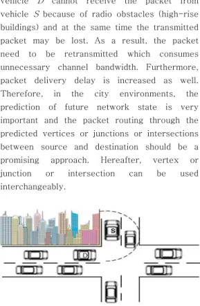
Such effects make routing quite difficult. As an inherent characteristic, vehicles do not move randomly but they are restricted to move in the roads with the roadside unit at certain speed. This makes the prediction of the future network state including geographic position, speed and direction of vehicles relatively easier in VANETs compared to the random mobility in general ad hoc networks. In city environments, high-rise buildings are the radio obstacles. In Fig. 1, vehicle S forwards a packet to vehicle D , where vehicle D is within the communication range of vehicle S but
vehicle D cannot receive the packet from vehicle S because of radio obstacles (high-rise buildings) and at the same time the transmitted packet may be lost. As a result, the packet need to be retransmitted which consumes unnecessary channel bandwidth. Furthermore, packet delivery delay is increased as well.
Therefore, in the city environments, the prediction of future network state is very important and the packet routing through the predicted vertices or junctions or intersections between source and destination should be a promising approach. Hereafter, vertex or junction or intersection can be used interchangeably.
Fig. 1. Effect of high-rise buildings in the inter-vehicle communication in city environment
The focus of this paper is the prediction of sequence of vertices for forwarding data from source vehicle to fixed infrastructure. In this paper, we propose a geographic position based routing for VANETs called Vertex-Based Predictive Greedy Routing ( VPGR ). It predicts a sequence of vertices from a source vehicle to a fixed infrastructure (or access point) at the area of interest and, then, forwards data to the destination (fixed infrastructure) using well-known predictive directional greedy forwarding mechanism [3], which will be described in detail in Section IV.2, through the sequence of vertices in city environments.
According to the simulation results, the proposed VPGR outperforms the conventional routing protocols in terms of packet delivery ratio, end-to-end delay and routing overhead.
The proposed VPGR protocol takes the
advantage of prediction of sequence of vertices and the predictive directional greedy forwarding technique [3] and results in more efficient and reliable routing. The main contributions of our work are as follows:
• VPGR uses the prediction technique for selecting valid vertices and making forwarding decision. Such a prediction leverages the useful knowledge of future network conditions.
(See Section III for the definition of a valid vertex.)
• VPGR always forwards packets through a sequence of valid vertices and, thus, there is less risk of packet loss due to wireless medium obstacles at the intersection of city area.
• VPGR saves channel bandwidth, reduces packet re-transmissions, increases reliability of packet delivery, and minimizes end-to-end delay.
The remainder of the paper is organized as follows: In the following section, VANET routing strategies found in the literature are overviewed. Section III outlines the system model, assumptions, and objectives of our work. The proposed vertex-based predictive greedy routing protocol is presented and discussed in detail in Section IV. Section V evaluates the performance of the scheme via extensive computer simulation. Finally, the paper is concluded with possible future work in Section VI.
Ⅱ. Related Work
Routing protocols for mobile ad hoc networks are categorized into topology based ones and location (or position) based ones.
Position based routing protocols outperform topology based ones in VANETs even though they have some limitations and drawbacks.
Many routing protocols have been proposed
in the literature in order to improve the performance [4-7, 9-10]. GPCR (Greedy Perimeter Coordinator Routing) [4] has been designed to deal with the challenges of the city environment. This employs restricted greedy forwarding strategies along in a predetermined path that selects a coordinator node as its next hop even if it is not the closest node to the destination.
GPSR (Greedy Perimeter Stateless Routing) [5] forwards a packet using so-called planar graph algorithm. But it takes large number of hops to get its destination and the path between source and destination is not optimal.
In GSR (Geographic Source Routing) [6], the shortest path between source and destination is calculated based on the street map. But, while calculating the shortest path, GSR does not consider whether there are enough vehicles or not on a street to provide connectivity between two involved junctions.
A-STAR (Anchor-based Street and Traffic Aware Routing) [7] was designed for inter-vehicle communication in city environment to identify anchor paths with higher connectivity. But, it utilizes the static vehicular traffic information based on the city bus route. Therefore, in GSR [6] and A-STAR [7], the selected path between source and destination might not be optimal. Moreover, they forward the packets using greedy forwarding techniques without consideration of the velocity and direction of vehicles while choosing intermediate nodes.
VADD (Vehicle Assisted Data Delivery) [9]
implemented predicable mobility by taking the traffic pattern and road layout into account. It is based on idea of carry and forward. It performs well even in sparse road conditions.
Epidemic routing [10] performs well even in
the harsh connectivity of sparse and rarely
connected networks. Both of the routing
protocols VADD and Epidemic routing increase
packet delivery ratio but consumes more
bandwidth as well as increase end-to-end
delay.
246 Multihop Vehicle-to-Infrastructure Routing Based on the Prediction of Valid Vertices for Vehicular Ad Hoc Networks
Ⅲ. System Model
We assume that each vehicle has a GPS receiver and is aware of its geographic position. Each vehicle knows the position of neighbors by hearing beacon messages that are periodically exchanged by vehicles. The road map is abstracted as a directed graph G (V, E) where V is set of vertices and E is set of edges. The position of destination is obtained with the help of map information provided by the navigation system. The proliferation of applications that may be running on VANETs in the near future suggests that vehicles will be equipped with wireless transceiver devices and sensing devices. Using such devices, vehicles can communicate with neighboring vehicles or fixed infrastructures within the radio range. The infrastructures are fixed roadside units whose absolute location is known to all vehicles.
VANETs consist of hundreds or thousands of highly mobile vehicles, and a few number of fixed infrastructures or access points (APs).
Upon sensing any event on the road, vehicles communicate in ad hoc manner among themselves to forward data from the source vehicle to the nearest AP. When a vehicle senses an event, it produces a message containing the event description and all the event-specific information such as message generation time (Tg) and a time-to-live (TTL) value. The message is considered to be successfully delivered if it is arrives at the nearest AP from the source vehicle before time (Tg + TTL) without any transmission error.
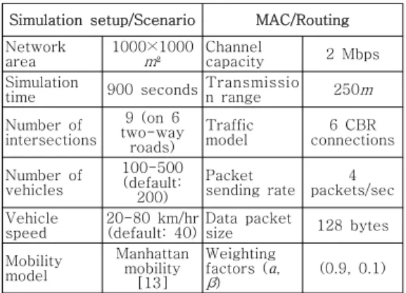
For the prediction of a sequence of vertices or junctions, a source vehicle identifies the number of involved junctions between the source vehicle and nearest AP from it. The remaining time RT(i, j) of vehicle i at vertex j is the time duration during which vehicle i remains within the threshold range T of vertex j. The vertex j is said to be valid if RT(i, j) ≥
τ, where τ is the minimum duration required for forwarding a packet from vehicle i to vertex j and depends on the underlying wireless technology. The calculation of RT(i, j) of vehicle i within the threshold range T of vertex j plays a significant role to make routing decision. Note here that the threshold range T of vertex j is set to the radio transmission range
of vehicle i for high-performance routing in this paper even though it can be dynamically set within
. That is, RT(i, j) can be effectively used to indicate whether the particular junction may provide connectivity for routing of data towards destination or not. If one of the vertices in its selected path is invalid, VPGR considers the next shortest path and follows the same procedure as discussed above. Note here that the prediction of a sequence of vertices will be presented in following section.
If all the vertices in a path are valid, the source vehicle forwards data through the sequence of vertices up to the destined fixed infrastructure in multihop fashion. For data forwarding, the conventional predictive directional greedy routing mechanism [3] is used.
IV. Vertex-Based Multihop Routing
In this section, the proposed Vertex-Based Predictive Greedy Routing ( VPGR ) protocol is presented in detail. VPGR performs two key operations: (i) predicting a sequence of vertices and (ii) forwarding data through the sequence of vertices by using well-known predictive directional greedy routing mechanism [3]. For the prediction of a sequence of vertices, a source vehicle identifies the number of involved junctions between itself and the nearest AP.
For the prediction of a sequence of valid
vertices, a source vehicle calculates the shortest path between itself and its nearest AP with the help of city map information provided by the navigation system. RT ( i , j ) is calculated only for the vehicles within the threshold range T from the center of vertex j and identifies whether a vertex is valid or not as presented in Section III. Note that T is set to the radio transmission range of vehicle i as described in Section III.
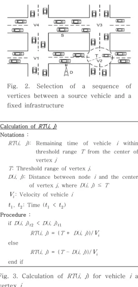
Fig. 2. Selection of a sequence of vertices between a source vehicle and a fixed infrastructure
Calculation of
RT
(i, j
) Notations :RT
(i
,j
): Remaining time of vehiclei
within threshold rangeT
from the center of vertexj
T
: Threshold range of vertexj
.D
(i
,j
): Distance between nodei
and the center of vertexj
, whereD
(i
,j
) ≤T
: Velocity of vehiclei
,
: Time (
<
) Procedure :if
D
(i
,j
) <D
(i
,j
)RT
(i
,j
) = {T
+D
(i
,j
)}/
elseRT
(i
,j
) = {T
–D
(i
,j
)}/
end ifFig. 3. Calculation of RT ( i , j ) for vehicle i at vertex j
The prediction of a sequence of vertices is explained with an example: In Fig. 2, let us suppose that the source vehicle S wishes to forward data to the nearest AP. The source
vehicle S identifies a sequence of junctions between itself and the nearest AP, with the help of city map information provided by the navigation system. In Fig. 2, the source vehicle S finds two routes to get the destination: S→
→
→D and S→
→
→D. The source vehicle selects the shortest one between possible paths. In case of tie, one of tied paths is randomly selected for simplicity. The source vehicle S identifies the number of involved vertices in the shortest paths and calculate RT(i, j) for each vertex or junction. The formal calculation procedure of RT(i, j) for vehicle i at vertex j is shown in Fig. 3. If a vertex is valid, we can say that the junction can provide connectivity for packet forwarding. In the selected shortest path, if one of the involved vertices is invalid, the source vehicle S chooses the next shortest path.
Once the sequence of valid vertices are determined, the existing predictive directional greedy routing (PDGR) mechanism [3] is used to forward data through the sequence of vertices from a source to the nearest AP. In PDGR, a forwarding vehicle calculates the weighted score not only for packet carrier and its current neighbors but also for its possible future neighbors in the very near future [3].
For the knowledge of the possible future neighbors, the packet requires two-hop neighbors’ information, which is possible by exchanging beacon messages among them. For this procedure, all data packets are marked with the sequence of vertices in its packet header. Each vehicle maintains a neighbor table, which contains information about node_id, position_of_node, velocity_of_node and direction_of_node of its neighbors. The neighbor table is updated by exchanging hello or beacon packets among neighboring vehicles.
With the help of information contained in the
neighbor table, a source vehicle calculates the
weighted score not only for itself and current
248 Multihop Vehicle-to-Infrastructure Routing Based on the Prediction of Valid Vertices for Vehicular Ad Hoc Networks
packet carrier but also for possible two-hop neighbors. If a neighbor has the higher score than the current packet carrier, the source vehicle forwards the packet to the neighbor;
otherwise, the current packet carrier carries the packet until it finds its neighbor which has higher weighted score than itself. The weighted score is calculated by
cos
as in [3]. Here,
and β are the weights for position and direction factors and + β = 1,
is the shortest distance from vehicle to destination (infrastructure),
is the shortest distance from forwarding node to destination;
is the closeness of the next candidate hop,
is the velocity vector on node i,
is the vector from the position of vehicle i to the position of destination, and cos
is the cosine value for the angle made by two vectors.
Greedy forwarding reduces end-to-end delay and the number of hops, but in some cases, it may suffer from topology hole [8]; it is a situation when a data packet reaches a host that does not have any neighbor closer than itself to the destination. These problems in greedy routing in position-first forwarding and direction-first forwarding can be solved by taking both position and direction into account when choosing the next-hop neighbor. The weighted score (
) described above includes a tradeoff between position-first and direction-first forwarding schemes.
Every node in the network periodically broadcasts a routing information ( RI ) packet to its neighbors. RI packet consists of the following fields: node_id, position, velocity, direction and acceleration of a node . With the exchange of RI packets, each node maintains a neighbor table of its neighbors. VPGR maintains routing table only for the involved vertices between the source vehicle and
nearest AP. In other words, the routing tables in the vehicles existing within the threshold range (T) of the involved vertices are maintained.
V. Performance Evaluation
In this section, we evaluate the performance of VPGR using ns-2 simulator (version 2.33) [12]. We compare the performance of VPGR with existing routing protocols of AODV [11]
and GPSR [5]. Note here that AODV (which is based on DSDV [16]) is the representative routing protocol standardized by the IETF MANET working group and GPSR is one of the typical geographic routing protocols referenced in many studies, respectively. As described earlier, PDGR [3], a subset of the proposed VPGR, is used for data forwarding in our VPGR implementation.
The experiment is based on a network area of 1000 × 1000
, which represents a grid layout of city roads. The area consists of 6 two-way roads and associated 9 vertices or intersections. This street layout is derived and normalized into a realistic mobility traces from a Manhattan mobility model [13]. These map data are transformed into the data format that can be used by the ns-2 simulator.
Table 1. Simulation parameters
Simulation setup/Scenario MAC/Routing Networkarea 1000×1000
m
² Channelcapacity 2 Mbps
Simulation
time 900 seconds Transmission range 250
m
Number ofintersections
9 (on 6 two-way
roads)
Traffic
model 6 CBR
connections
Number of vehicles
100-500 (default:
200)
Packet
sending rate 4 packets/sec Vehicle
speed 20-80 km/hr
(default: 40)Data packet
size 128 bytes
Mobility model
Manhattan mobility
[13]
Weighting factors (
α
,β
) (0.9, 0.1)The node density is varied from 100 to 500
vehicles deployed on the map, the default value of which is 200. Each vehicle has radio transmission range of 250m. The speed of vehicles is chosen between 20-80 km/hr, the default value of which is 40 km/hr. For the performance evaluation, 6 random connections were established using the CBR traffic of 4 packets/second with a packet size of 128 bytes. IEEE 802.11 DCF is used for the network interface with channel capacity of 2 Mbps. The simulation results are averaged over repetitive runs. Each simulation run takes 900 seconds (15 minutes) of simulation time.
The performance metrics used to evaluate the simulation results in this paper are as follows:
• Packet delivery ratio: the ratio of the number of data packets successfully delivered to the destination over the number of data packets sent by the source.
• Average end-to-end delay: the average time it takes for a packet to transverse the network from source to destination.
• Routing overhead: the ratio of the number of bytes of total control packets to those of total data packets delivered to the destination during the entire simulation.
The three algorithms of AODV, GPSR and the proposed VPGR are compared under various values of node (vehicle) density and node speed.
2.1 Packet Delivery Ratio
In this section, we will show how the performance of packet delivery is affected under the different node density and speed for AODV, GPSR and VPGR.
In Fig. 4(a), VPGR achieves the highest packet delivery ratio for the different number of nodes. It is also observed that more packets are delivered as the node density increases.
(a)
(b)
Fig. 4. Packet delivery ratio vs. (a) number of nodes and (b) maximum node speed
In GPSR, the packet delivery ratio is slightly decreased up to 300 nodes but, after that point, the packet delivery ratio is linearly increased. In AODV, the packet delivery ratio is linearly decreased with the increasing number of nodes. With the prediction technique, VPGR shows the best performance because it can select the best vertex to route and the best next hop, both of which enhance the reliability in packet delivery. At high node density, VPGR delivers almost 50% more packets than GPSR.
Fig. 4(b) shows the packet delivery ratio
with respect to varying node speed. The
delivery ratio of GPSR is worst among three
routing protocols (almost less than 40%). This is
because GPSR suffers from frequent routing
250 Multihop Vehicle-to-Infrastructure Routing Based on the Prediction of Valid Vertices for Vehicular Ad Hoc Networks
holes at the node placement only in perimeter mode [5]. The delivery ratio of AODV is linearly decreased as the speed increases. Since AODV is a reactive routing protocol, it performs route recovery whenever the packet is dropped due to route breakage. VPGR shows higher delivery performance in all the speed level because the source node always finds the predefined route (through the predefined valid vertices) to the destination AP. In VPGR, the packet delivery ratio is rapidly decreased beyond 60 km/hr, but still maintains almost 80%
of packet delivery.
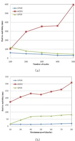
2.2 End-to-End Delay
In this section, we compare the performance of AODV, GPSR and VPGR in terms of end-to-end delay.
(a)
(b)
Fig. 5. End-to-end delay vs. (a) number of nodes and (b) maximum node speed As shown in the Fig. 5 (a), VPGR achieves
a much lower end-to-end delay than AODV and GPSR in all the configurations. This is because (i) the number of hops involved to deliver a packet in VPGR is reduced due to predictive directional greedy routing and (ii) VPGR does not need to keep track of an end-to-end route before sending packets from source to the destination AP. In contrast, the reactive routing protocols like AODV use an on-demand route discovery mechanism which causes longer delay. At very high node density (500 nodes), the end-to-end delay is drastically increased.
As shown in Fig. 5(b), VPGR has much lower end-to-end delay than AODV and GPSR.
AODV performs a route discovery process in reactive way whenever the current path or route is broken. That is why the end-to-end delay of AODV is the worst and it is linearly increased with the increased speed. As the increased node speed results in a link breakage, GPSR also encounters longer delay than VPGR.
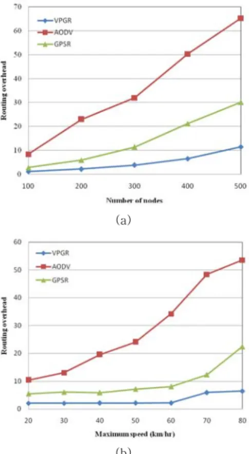
2.3 Routing Overhead
In Fig. 6(a), we evaluate the routing overhead of the three routing protocols with different node densities. VPGR outperforms the other two routing protocols. In all the routing protocols, it is observed that the increase in vehicle density leads to the increase in routing overhead since the rate of control messages depends on the number of nodes. In VPGR, only the routing information (RI) packet is used as a control message. It is a contrast to the three types of control messages (i.e., RREQ, RREP and RERR) used for route discovery and route maintenance in AODV. In GPSR, HELLO packets are used. This is why VPGR and GPSR have lower overhead compared to AODV.
In Fig. 6(b), we evaluate the routing
overhead of the three routing protocols with
varying vehicle speed. VPGR outperforms the
other two routing protocols as well. As shown in
Fig. 6(a), it is also observed that the increase in
vehicle speed leads to the increase in routing
overhead since the rate of control messages is increased with the number of broken links. Note here that the increased node speed results in more link breakages and, thus, more control packets should be transmitted. As a result, the routing overhead is linearly increased with the increased node speed. In VPGR and GPSR, the overhead is remarkably increased beyond 60 km/hr compared to the lower speed.
(a)
(b)
Fig. 6. Routing overhead vs. (a) number of nodes and (b) maximum node speed
VI. Conclusions
In this paper, the geographic prediction based routing protocol so-called vertex-based predictive greedy routing (VPGR) protocol has been proposed for vehicular ad hoc networks in city environment. VPGR leverages the geographic position, velocity, direction and
acceleration of vehicles and performs the two key operations of (i) the prediction of a sequence of vertices and (ii) the use of the predictive directional greedy routing to forward the data from source vehicle to destination infrastructure through the sequence of vertices.
The proposed routing protocol has been evaluated using the network simulator ns-2 and compared with GPSR and AODV for different conditions. The simulation results show that the proposed VPGR outperforms GPSR and AODV in terms of packet delivery ratio, end-to-end delay and routing overhead.
That is, VPGR achieves higher performance and more reliable routing than GPSR and AODV.
Our proposed routing protocol selects vertices and intermediate vehicles in the city environment where sufficient vehicles are on the roads. As a future work, we are investigating the scenarios with relatively low vehicle density to extend VPGR, in which the so-called store-carry-and-forward technique might be useful and can be exploited. To extend VPGR for vehicle-to-vehicle routing is also our future work.
References
252 Multihop Vehicle-to-Infrastructure Routing Based on the Prediction of Valid Vertices for Vehicular Ad Hoc Networks
저 자 소 개
Sangman MohDr. Sangman Moh received the Ph.D. degree in computer engineering from Korea Advanced Institute of Science and Technology (KAIST), Daejeon, Korea in 2002.
Since late 2002, he has been a faculty member in the School of Computer Engineering at Chosun University, Gwangju, Korea. From 2006 to 2007, he was on leave at Cleveland State University, Cleveland, USA. Until 2002, he had been with Electronics and Telecommunications Research Institute (ETRI), Daejeon, Korea, where he served as a project leader, since he received the M.S. degree in computer science from Yonsei University, Seoul, Korea in 1991. His research interests include mobile computing and networking, ad hoc networks and systems, ubiquitous sensor networks, network based computing, parallel and distributed computing, and high-performance computer systems. He has published more than 100 papers in international and domestic journals and conference proceedings, and has held more than 40 overseas and domestic patents.
He serves on the program committees of international conferences and workshops in his areas of interest. Dr. Moh is a member of the IEEE, the ACM, the IEICE, the KIISE, the IEEK, the KIPS, the KICS, the KMMS, the IEMEK, and the KPEA.
Email : [email protected]
Raj K. Shrestha
Mr. Raj K. Shrestha received the B.E. degree in information technology from Purbanchal University, Nepal in 2005 and the M.E.
degree in computer engineering from Chosun University, Gwangju, Korea in 2009. From 2005 to 2006, he was with Syspro International Pvt. Ltd., Nepal. His interest areas include mobile ad hoc networks, vehicular ad hoc networks, and wireless sensor networks.
Email : [email protected]
Ilyong Chung
Dr. Ilyong Chung received the B.E. degree from Hanyang University, Seoul, Korea in 1983 and the M.S. and Ph.D. degrees in computer science from City University of New York in 1987 and 1991, respectively.
From 1991 to 1994, he was a senior technical staff at Electronics and Telecommunications Research Institute (ETRI), Dajeon, Korea. Since 1994, he has been a Professor in the Department of Computer Engineering at Chosun University, Gwangju, Korea. His research interests are in areas of computer networking, security systems and coding theory.
Email : [email protected]
Heewook Shin