in the Forest Catchment 1
- A Study of the Lake Shirarutoro Area in Northern Japan - Young-Sang Ahn
2*산림유역의 토지변형에 따른 수질과 토사생산량 변화 1
- 일본 시라루토로호수 지역의 연구 결과 - 안영상
2*1 접수 2009년 10월 31일, 수정(1차: 2009년 12월 16일), 게재확정 2009년 12월 17일 Received 31 October 2009; Revised(1st: 16 December 2009); Accepted 17 December 2009
2 국립산림과학원 산림복원연구과 Division of Forest Restoration, Korea Forest Research Institute, 57, Hoegi-Ro, Dongdaemun-Gu, Seoul(130-712), Republic of Korea([email protected])
* 교신저자 Corresponding author([email protected])
ABSTRACT
Sediment and nutrient loading caused by the removal of forest cover and alteration of agricultural lands in catchments have led to the deterioration in Lake Shirarutoro. To examine the effects of deforestation and agricultural activities on water quality, I examined changes in total nitrogen (TN) and total phosphorus (TP) of lake water induced by land use change, and compared them with the various research data produced over the years. Our investigation showed that the level of TN and TP in the lake water decreased when forest cover increased but increased when farmland area increased. The concentration of TN and TP was high in Lake Shirarutoro despite that its catchment was surrounded by large forests and small farmlands. This result indicates that land uses near Lake Shirarutoro have affected the quality of the lake water. I have examined the changes of sediment yield in the lake's catchment over the last approximately 300 years. Eleven core samples were obtained from the lake sediment and analyzed to establish a chronology after using two tephra layers (Ko-c2 in 1694 and Ta-a in 1739) and a
137Cs peak (in 1963). The average sediment yield under the natural condition during the first two periods was 8.4 tons/km
2/year in 1694~1739 and 8.9 tons/km
2/year in 1739~1963 respectively. The conversion of the Shirarutoro catchment into agricultural lands and deforestation intensified, leading to an increased sediment yield of 21.1 tons/km
2/year during 1963~2007.
KEY WORDS: DEFORESTATION, AGRICULTURAL LAND, TOTAL NITROGEN(TN), TOTAL
PHOSPHORUS(TP), FINE SEDIMENT
요 약
산림벌채와 농경지 개발에 의한 토사와 영양염류의 유출은 시라루토로호수의 생물서식지 환경을 악화시키고 있다.
산림벌채와 농업활동이 수질에 미치는 영향을 조사하기 위해 토지이용에 따른 총질소와 총인의 변화를 분석하고, 이들의 분석 결과를 다른 연구자료와 비교하였다. 호수의 총질소와 총인은 산림면적 증가에 따라 감소하고, 농지면적이 증가하 면 높은 농도를 나타내었다. 그러나 시라루토로호수의 수질은 좁은 농지면적과 넓은 산림으로 둘러싸여 있음에도 불구하 고 총질소와 총인의 농도가 높게 나타났다. 이는 유역의 토지이용이 호수에 인접한 곳에서 행해지고 있어 호수 수질에 영향을 미친 것으로 사료되었다. 토지이용에 따른 유역의 토사생산량 변화를 추정하기 위해 호수 토사퇴적물 시료 11개를 채취하여 약 300년 동안의 토사동태를 조사하였다. 채취한 호수 퇴적물에는 2개의 화산재층(1694년의 Ko-c2층 과 1739년의 Ta-a층)과 세슘(137Cs)피크(1963년)가 존재하였고, 이들의 연대를 이용하여 약 300년간 유역의 토사생산량 을 분석하였다. 초기개발기(1694~1739과 1739~1963)에는 8.4~8.9 tons/㎢/year의 토사가 유역으로부터 생산되었고, 1960년대 이후 산림벌채와 농지개발로 인하여 21.1 tons/㎢/year(1963~2007)으로 토사생산량이 증가하였다.
주요어: 산림벌채, 농경지, 총질소, 총인, 세립토사
INTRODUCTION
Nutrients and sediment are carried in large quantities by rivers after timber harvesting, agricultural activity and channelization(Slaymaker, 1982; Nakamura et al., 1997, 2004; Ahn et al., 2006, 2008, 2009). These materials are carried to streams and lakes. The increase in nutrient load degrades aquatic habitats by increasing the number of phytoplankton and decreasing water translucency (Takamura
et al., 2003). In addition, respiration is impaired in aquatic
organisms by fine sediment(Lemly, 1982). Much of the worldwide loss of aquatic habitats is attributed to deforestation and conversion to agricultural land. In order to prevent further degradation of lake water quality, it is important to understand the effect of land use change on sediment and nutrient loads.The Kushiro Mire is the largest wetland in Japan, and it embraces a diversity of wetland habitats for many types of wildlife. It was designated as a national park in 1987.
The first settlement in the Kushiro catchment was founded in the 1880s, with a major conversion of floodplain to agricultural land in 1950s. Agricultural law enacted in 1961 has promoted a consolidation of the agricultural land and introduction of agricultural machinery(Nakamura et
al., 2002). The excessive production of nutrients and
sediment in association with expanding agricultural land is the most serious environmental issues in the Kushiro Mire(Nakamura et al., 2002; 2004). The cumulative impact of nutrient and sediment from uplands maydeteriorate the quality of wetlands and accelerate their loss despite the fact that they are designated as a National Park and are supposed to be protected from development. Lake Shirarutoro is located on the eastern margin of the Kushiro Mire, and has recently suffered from accelerated rate of sedimentation and degradation in water quality due to the flooding of nutrient-rich turbid water into the lakes (Takamura et al., 2003). Water drains into Lake Shirarutoro from the Shirarutoroetoro River and other small tributaries and flows into the Kushiro River. At very high water levels, however, water from the Kushiro River frequently flows back into Lake Shirarutoro(Ahn, in press).
Therefore, Lake Shirarutoro is influenced by inflow from its catchments as well as from the Kushiro River. Previous studies reported accelerated shallowing in Lake Shirarutoro (Ahn, in press) and floristic degradation in the lake over the last 10 years(Takamura et al., 2003). The major causes of these problems are sediment influx and phytoplankton biomass both enhanced significantly in the lake.
The objective of this study was to describe the delivery of total nitrogen(TN) and total phosphorus(TP) in order to help explain environmental deterioration in Lake Shirarutoro. First, I investigated the relationship between land use change and water quality(concentrations of TN and TP) of the lake. Second, I examined the sediment yield of the Lake Shirarutoro catchment over the last 300 years.
I clarified the influence of land use change on sediment yield using 137Cs and tephra as marker layers.
The Kushiro Mire(194㎢) lies in eastern Hokkaido, northern Japan, and drains into the Kushiro River. The Kushiro district is in the Pacific coast climate zone, with an annual mean air temperature of 6.0°C during 1971 to 2006(Japan Meteorological Agency, 2007). The annual mean precipitation is 1037mm, with a range of 705~
1,378mm.
Lake Shirarutoro is a small lake with an area of 1.8㎢
and drains a 65㎢ catchment into the Kushiro River at the eastern margin of the Kushiro Mire(Figure 1). It was formed about 3000 years ago by sea regression. The maximum water depth measured in this investigation was 2.4m. Under high flow conditions, the Kushiro River drains back into Lake Shirarutoro because the elevations of Lake Shirarutoro and the Kushiro River are almost equal to each other(Ahn et al., 2008). Lake Shirarutoro is surrounded by hills of 100m height. The lithology of the Shirarutoro area consists of tuff and unconsolidated gravel deposits. Lake Shirarutoro is surrounded by wetlands with dominant plant species such as reeds (Phragmites australis), alder(Alnus japonica) and willow (Salix sachalinensis). Moreover, the headwaters of the Shirarutoro catchment are covered by planted forests(Larix
leptolepis) and indigenous forests(Quercus crispula).
Prior to modern Japanese settlement in the Lake Shirarutoro catchment, Ainu(native people) had been using the area for hunting and fishing as well as for crops and timber. As the Japanese settlement began in the 1880s, the forest was partly cleared(Kumagai et al., 2008). Major deforestation and conversion of forest areas to agricultural land has been undertaken in the Shirarutoroetoro River catchment since the 1960s. Agricultural laws established in 1961 have promoted further land conversion. Although reforestation with L. leptolepis aimed to recover forest resources, deforestation and conversion to agricultural land have continued.
MATERIALS AND METHODS
1. Total nitrogen and total phosphorus
To investigate TN and TP concentrations in the lake
during dry periods(between 2006 and 2007)(Figure 1). The samples were stored at 5℃ for nutrient analyses. Total nitrogen was measured by NO3-N concentration after hydrolysis with alkaline potassium persulfate in an autoclave at 121℃ for 30min. Total phosphorus was measured by PO4-P concentration after hydrolysis in an autoclave at 121℃ for 30min(TRAACS800, Bran-Luebbe) (Mikami et al., 2002; Ahn et al., 2008).
2. Sediment yield
Long-term sediment yields of the lake catchment have been reconstructed from 11 lake sediment profiles collected in 2007(Ahn, in press)(Figure 1). The most distinctive and widespread tephras over the study areas were Komagatake-c2 tephra(Ko-c2, 1694 AD) and Tarumae-a tephra(Ta-a, 1739 AD). All core samples in Lake Shirarutoro contained two tephra layers. Ahn et
al.(2006) identified two tephra layers from Lake Takkobu
in the Kushiro Mire using the refractive indices of tephra glasses. The lower tephra layer was identified as Ko-c2(1694) and the upper tephra layer as Ta-a(1739).137Cs(half-life 30 years) is an artificially created radionuclide which was released by a series of atmospheric nuclear tests during the mid-twentieth century.
Atmospheric deposition of 137Cs first began in 1954, with one peak in fallout occurring in 1963. The sediment- associated 137Cs represents radiocaesium originating as fallout over the surface of the upstream catchment, which has been adsorbed by sediment particles and subsequently mobilized by erosion and transported downstream as part of the fine sediment load of the rivers. This fine sediment load and its associated 137Cs will be deposited in the lake during flooding events. The 137Cs peak concentration profile in the lake was found in the 1963 surface(Ahn et
al., 2006; in press).
137Cs concentrations in sediment have been measured by a number of researchers to estimate the sedimentation rates which have occurred in the past 40 years. The 137Cs content of the cores were measured over 2~3cm intervals. 137Cs concentrations were assayed by gamma spectrometry at 662 keV using HPGe detectors coupled to a multichannel analyzer.The average sedimentation rate was calculated using
137Cs dating and tephrochronology(Ahn, in press). To
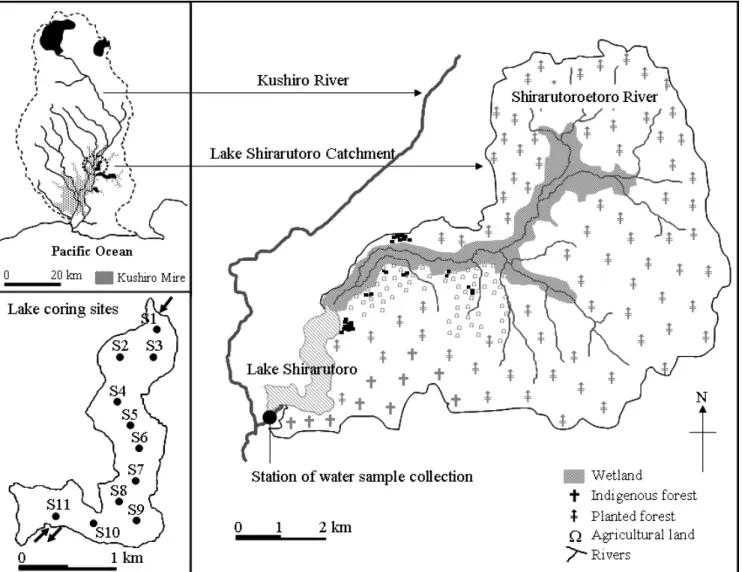
Figure 1. Map of the Lake Shirarutoro catchment and the location of the study sites, as well as station of water sample collection and the lake coring sites
calculate the sediment mass, the lake was divided into polygons using the Thiessen method, with each coring point located in the center of each polygon(Ahn et al., in press). The sediment mass was estimated by multiplying the polygon area represented by each coring point with the average rate of sedimentation at that point. Estimates of the catchment sediment yield were obtained by taking the total sediment mass and dividing it by the catchment area. The Brown(1944) trap efficiency(the percentage of incoming sediment deposited within the lake) was used to adjust sediment yields. The trap efficiency was based on ratio between lake storage capacity and drainage area.
To reconstruct the total sediment mass, the lake was divided into polygons using the Thiessen method, with
each coring point located in the center of each polygon(Ahn et al., 2006). The sediment mass for each Thiessen polygon was estimated by multiplying the polygon area represented by each coring point with the average rate of sedimentation at that point.
RESULTS AND DISCUSSION
Lake habitats have degraded or been lost due to the decline in translucency caused by increased phytoplankton following nutrient loads. In addition, stress by impairing respiration due to fine sediment influx caused by various human activities has also affected these environments.
Previous studies have consistently indicated that
Total nitrogen(㎍/ℓ) average(range)
Total phosphorus(㎍/ℓ) average(range)
Lake Shirarutoro 558(280~740) 54(15~84)
Table 1. The concentrations of total nitrogen and total phosphorus in Lake Shirarutoro water Shirarutoro are rapidly being altered in association with
deteriorating water quality(Takamura et al., 2003). In addition, fine sediment accumulation has strongly influenced the shallowing process of the lake(Ahn, in press).
1. Effect of land use development on lake water quality
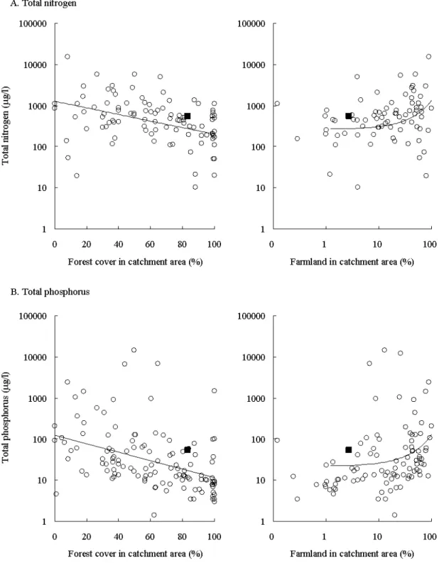
The average TN and TP concentrations of lake water were 558㎍/ℓand 54㎍/ℓ, respectively(Table 1 and Figure 2). To examine the effects of deforestation and agricultural activities on water quality, I related the TN and TP concentrations to land use change, and compared these with existing world inventory data(ILEC, 1994, 1995, 1996).
The nutrient concentrations became greater as more catchment areas were converted from forest to farmland (Figure 2). I plotted the results from Lake Shirarutoro with world data(Figure 2). The results from Lake Shirarutoro showed higher values compared to those of the similar forest and farmland covers. It seemed that nutrient outflow was accelerated during the process of deforestation and agricultural activities. Forest conversion to farmland has increased in the Lake Shirarutoro catchments since 1960s(Figure 1). The areas under agricultural activities had increased especially following the low lands and floodplains(Figure 1). Recently, forests were harvested over a large areas of the lake catchment and forest roads were constructed. Although reforestation with L. leptolepis was underway, timber harvesting was continued for pulp industry. After deforestation, nutrients seemed to be released by litter decomposition and no longer taken up by plants(Bormann et al., 1968; Polyakova and Billor, 2007). Nitrate concentrations in small streams of the deforested areas had increased to induce water pollution and algal bloom in summer(Bormann et al., 1968). In
river water whose catchments were dominated by farmland(Inoue and Ebise, 1991; House and Warwick, 1998; Scanlon et al., 2004). Although the climate of the study site is different from that of the world inventory sites, water quality of Lake Shirarutoro was high compared to that of the similar land use intensity. This seemed to be due to the TN and TP carried by the stream network from the deforested and agricultural areas located close to the streams and lake, and the lake received nutrients from the Kushiro River during a flood. Conversion of the Kushiro River catchment area ended up cattle farms, and lands were consolidated by farm tractors since 1960s(Nakamura et al. 2004).
2. Effect of land transformation on sediment yield
The total sediment mass in Lake Shirarutoro over the last 300 years was investigated for three periods (1694~1739, 1739~1963 and 1963~2007) using tephra and
137Cs as marker layers(Ahn, in press). Core samples collected from Lake Shirarutoro contained two tephra layers(Komagatake-c2 tephra in 1694 and Tarumae-a tephra in 1739). A clear peak in the 137Cs concentration was detected from all the sampling points, which is the sediment layer of 1963. The total sediment mass for the first two periods were 514 tons/year from 1694 to 1739 and 542tons/year from 1739 to 1963(Ahn, in press). The total sediment mass after 1963 increased to 1261tons/year.
Compared with the sediment mass of 533tons/year prior to 1963, sediment mass has been significantly increased after 1963(Ahn, in press).
Ainu, the native people, settled in the Lake Shirarutoro catchment area. They mostly used the land for crop and timber. However, the extent of exploiting natural resources was limited. Japanese settlement in the lake catchment area started during 1880s, and a part of the forest was harvested for charcoal production(Kumagai et al., 2008). However, Japanese settlement was not extensive until 1950 because
Figure 2. Relationships between concentration of suspended sediment, total nitrogen and total phosphorus and forest cover and farmland area in the catchments(The open circles indicate the existing world inventory data and the closed squares show the Lake Shirarutoro data.)
they did not want to live together with native people (personal communication with local residents).
Deforestation and agricultural activities took place since 1960. Therefore, the sediment yields of the first two
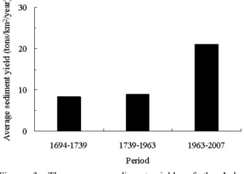
Figure 3. The average sediment yields of the Lake Shirarutoro catchment over the last 300 years
periods reflect natural erosion. The periods of 1963~2007 are characterized by deforestation and agricultural land use. The sediment trap efficiency over the three periods (1694~1739, 1739~1963 and 1963~2007) were 94.0, 92.7 and 91.4%, respectively. The average sediment yield by natural erosion was 8.4tons/㎢/year in 1694~1739 and 8.9tons/㎢/year in 1739~1963(Figure 3). Deforestation and extensive land transformation caused an increase up to 21.1tons/㎢/year during 1963~2007, showing more than two-fold increase in sediment yield. This suggests that the increase in sediment yield for the last 45 years is related to the land transformation, and particularly to the proportional increase of farmland areas converted from forests and floodplains. The sediment yields from the Lake Shirarutoro catchment area for the past approximately 300 years indicated that deforestation and land transformation increased sediment yield contributing to the accelerated shallowing process of the lake.
LITERATURE CITED
Ahn, Y.S.(in press) Historical changes of sediment accumulation in Lake Shirarutoro due to land use development in the forest catchment, Kushiro Mire in northern Japan. Korean Journal of Limnology.
Ahn, Y.S., F. Nakamura and S. Mizugaki(2008) Hydrology, sus- pended sediment dynamics and nutrient loading in Lake Takkobu, a degrading lake ecosystem in Kushiro Mire, north- ern Japan. Environmental Monitoring and Assessment 145:
267-281.
Elevated sedimentation in lake records linked to agricultural activities in the Ishikari River floodplain, northern Japan. Earth Surface Processes and Landforms 34(12): 1,650-1,660.
Ahn, Y.S., S. Mizugaki, F. Nakamura and Y. Nakamura(2006) Historical change in lake sedimentation in Lake Takkobu, Kushiro Mire, northern Japan over the last 300 years.
Geomorphology 78: 321-334.
Bormann, F.H., G.E. Likens, D.W. Fisher and R.S. Pierce(1968) Nutrient Loss Accelerated by Clear-Cutting of a Forest Ecosystem. Science 159(3817): 882-884.
Brown, C.B.(1944) Discussion of sedimentation in reservoirs.
Transactions of the American Society of Civil Engineers 109:
1,080-1,086.
House, W.A. and M.S. Warwick(1998) Hysteresis of the solute con- centration/discharge relationship in rivers during storms.
Water Resources Research 32(8): 2,279-2,290.
Inoue, T. and S. Ebise(1991) Runoff characteristics of COD, BOD, C, N and P loading from rivers to enclosed coastal seas. Marine Pollution Bulletin 23: 11-14.
International Lake Environment Committee Foundation(ILEC) (1994) Compact-size edition of data book of world lake environments. A survey of the state of world lakes; Africa and Europe. Miyagawa Printing Co. Ltd., Otsu, 852pp.
International Lake EnvironmentCommittee Foundation(ILEC) (1995) Compact-size edition of data book of world lake environments. A survey of the state of world lakes; Asia and Oceania. Miyagawa Printing Co. Ltd., Otsu, 672pp.
International Lake EnvironmentCommittee Foundation(ILEC) (1996) Compact-size edition of data book of world lake environments. A survey of the state of world lakes; The Americas. Miyagawa Printing Co. Ltd., Otsu, 868pp.
Japan Meteorological Agency(2007) http://www.jma.go.jp/
jma/index.html (in Japanese).
Kumagai, Y., Y.S. Ahn and F. Nakamura(2008) Recent human im- pact on vegetation in Takkobu, northern Japan, reconstructed from fossil pollen in lake sediments. Journal of Forest Research 13: 223-232.
Lemly, A.D.(1982) Modification of benthic insect communities in polluted streams: combined effects of sedimentation and nu- trient enrichment. Hydrobiologia 87: 229-245.
Mikami, H., S. Hino, K. Sakata and J. Arisue(2002) Variations in environmental factors and their effects on biological character- istics of meromictic Lake Abashiri. Limnology 3: 97-105.
Nakamura, F., J. Mieko, S. Kameyama and S. Mizugaki(2002) Changes in riparian forest in the Kushiro Mire, Japan, asso- ciated with stream channelization. River Research and Applications 18: 65-79.
Nakamura, F., S. Kameyama and S. Mizugaki(2004) Rapid shrink-
age of Kushiro Mire, the largest mire in Japan, due to increased sedimentation associated with land-use development in the catchment. Catena 55: 213-229.
Nakamura, F., T. Sudo, S. Kameyama and J. Mieko(1997) Influences of channelization on discharge of suspended sedi- ment and wetland vegetation in Kushiro Marsh, northern Japan.
Geomorphology 18: 279-289.
Polyakova, O. and N. Billor(2007) Impact of deciduous tree species on litterfall quality, decomposition rates and nutrient circu- lation in pine stands. Forest Ecology and Management 253:
11-18.
Scanlon, T.M., G. Kiely and Q. Xie(2004) A nested catchment ap- proach for defining the hydrological controls on non-point phosphorus transport. Journal of Hydrology 291: 218-231.
Slaymaker, O.(1982) Land use effects on sediment yield and quality. Hydrobiologia 91: 93-109.
Takamura, N., Y. Kadono, M. Fukushima, M. Nakagawa and B.H.O. Kim(2003) Effects of aquatic macrophytes on water quality and phytoplankton communities in shallow lakes.
Ecological Research 18: 381-395.