ABSTRACT: A novel high-resolution high-frequency range mag- netotelluric (HFMT) survey was conducted to image an intertidal succession in a macrotidal environment. In Gomso Bay of the southwestern coast of Korea, HFMT data were collected on a line (∼1 km) comprising 21 recording sites at 50 m intervals. A two- dimensional section was constructed from the transverse magnetic (TM) mode, inspected by electromagnetic array profiling (EMAP) filtering and one-dimensional Bostick inversion. The image is demarked by two distinct discontinuities. The lower one is inter- preted as a boundary between the basement of high resistivity and the overlying tidal deposits of low resistivity. The upper one is expected to be a significant layer of relatively high resistivity within low resistivity deposits. This is suggestive of nonmarine/tidal strata experiencing prolonged subaerial exposures within tidal successions.
In a tidal-flat environment, the HFMT probing seems to effectively configure boundaries between the basement and successions of different physical properties.
Key words: high-frequency magnetotelluric, tidal deposits, macrotidal, Yellow Sea, Gomso Bay
1. INTRODUCTION
A novel high-resolution high-frequency magnetotelluric (HFMT) survey was conducted to image an intertidal suc- cession in a macrotidal environment. Tidal flats are not only where land seismic methods are not well applied owing to softness of the substratum, but also where the deployment of marine seismics performs poorly because of shallow water depth and man-made fishery obstacles. DC-electrical methods are also prohibited by the high conductivity of salt in pore water. As an important nonseismic tool, the HFMT profiling has been tested to distinguish boundaries between tidal-flat successions and the basement.
In the southeastern Yellow Sea, Gomso Bay is a large, eastwest-oriented, funnel-shaped embayment (Fig. 1) where tides are semidiurnal with a macrotidal range of av. 4.3 m (National Geography Institute, 1981). The basement com- prises Cretaceous volcanics, Jurassic granite, and Precam- brian crystalline schist (National Geography Institute, 1981).
Tidal-flat successions overlie the basement, undergoing high-frequency sea-level fluctuations during the late Qua- ternary (Jin and Chough, 1998; Kim et al., 1999; Chough et al., 2000). In a tidal-flat environment, this study helps image
the basement geometry and strata of different physical properties.
2. GEOLOGICAL AND OCEANOGRAPHIC SETTING
The Yellow Sea is a shallow epicontinental sea (~55 m deep on average), surrounded by the landmass of China and Korea (Fig. 1). It has been supposed to be tectonically sta- ble since the Late Miocene (Chough, 1983; Chough et al., 2000). Glacio-eustatic sea-level fluctuations during the Quaternary had a great effect on sedimentation in the Yel- low Sea and adjacent shallow seas (Chough et al., 2000; Jin et al., 2002). Chinese onshore and offshore deep boreholes have revealed alternating terrestrial and shallow marine deposits that resulted from sedimentation under repeated transgressions and regressions during the Pleistocene (Li et al., 1991; Marsset et al., 1996). The present shape of the Yellow Sea is a result of large-scale Holocene (< 18,000 years B.P.) transgression across more than a thousand kilometer of the long stretch of the pre-Holocene terrestrial lowlands between China and Korea (Chough, 1983; Chough et al., 2000). Prior to 6000 years B.P., the sea level rose rapidly to ∼10 m below the present level and continued to slowly rise forming the present Yellow Sea (Pirazzoli, 1991).
Based on vibracores (< 5 m deep) in Gomso Bay, the Holocene transgressive intertidal deposits unconformably overlie the pre-Holocene semi-consolidated, oxidized floodplain depos- its, forming a retrograding, coarsening-upward succession (Kim et al., 1999). The Holocene succession comprises tidal deposits of mud-flat, mixed-flat, and sand-flat environments.
The reconstructed sea-level curve in Holocene suggests that the mean sea level has risen continuously during the past 2000 years at an average rate of 0.9−1.3 mm/yr (Kim et al., 1999). In the macrotidal Gomso Bay, peak tidal currents in the main tidal channel attain 1.2 m/s during flood and 1.5 m/s during ebb (National Geography Institute 1981). A shelly sand ridge occurs adjacent to the shoreline on the high tidal mud flat near the mouth of the bay (Lee et al., 1994).
3. MAGNETOTELLURIC DATA
The conventional magnetotelluric (MT) method, a geo- physical depth-sounding technique measuring Earth’s nat- Woo Hun Ryang*
Howoong Shon
Division of Science Education, Chonbuk National University, Jeonju 561-756, Korea
Department of Civil and Geotechnical Engineering, Paichai University, Daejeon 302-735, Korea
*Corresponding author: [email protected]
294 Woo Hun Ryang and Howoong Shon
ural time-varying electromagnetic fields, probes subsurface structure of electrical resistivity, typically in the band from 0.001 to 20,000 Hz (Caniard, 1953; Vozoff, 1991; Torres- Verdin and Bostick, 1992). The simultaneous electrical and magnetic measurements are made using a band of frequen- cies that translates to a section of investigation depths. In this study, the HFMT using the IMAGEM system (Nichols et al., 1994) was adopted in the frequency range of 10 to 100,000 Hz which is higher than that of conventional MT.
This frequency range probes a few kilometer depth, depending on the effective penetration electromagnetic energy, , where d, ρ, and f represent skin depth, electrical resistivity, and frequency, respectively (Swift, 1986; Vozoff, 1991). In sediments and rocks, the presence of conductive substances such as liquid water, NaCl, or chemical substance is inversely proportional to the electrical resistivity (Cagniard, 1953; Palacky, 1987). The porosity of unconsolidated sed- iments is more conductive than that of semi-consolidated sediments or sedimentary rocks (Vozoff, 1972; Palacky, 1987).
Our field survey was performed in tidal-flat deposits satu- rated with saline water, therefore the penetration depth was adjusted by multiplying a coefficient of 0.5 to meet this conductive environment (Jupp and Vozoff, 1976; Kuznet- zov, 1982; Zonge and Huges, 1991).
Field and theoretical MT studies have shown that low- frequency electric amplitude response from the subsurface can be dominated by the response from the shallowest resis- tivity anomalies (Swift, 1967, Word et al., 1969, Torres-Verdin and Bostick, 1992). To overcome spatial aliasing effects
associated with the sampling of the surface electric field, electromagnetic array profiling (EMAP) of HFMT was applied.
In the EMAP field procedure, electric dipoles are posi-
d≅500 ρ⁄f
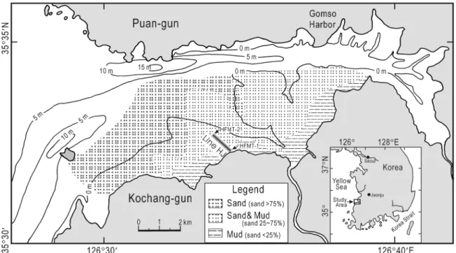
Fig. 1. Location map of Gomso Bay showing bathymetry, HFMT line, and surface sediment distribution (modified from Kim et al., 1999, Chang et al., 1996, and Lee et al., 1994). Transect line HJMT is across the tidal flat. Note that the sediments coarsen seaward and toward the northern main tidal channel (Kim et al., 1999).
Fig. 2. A diagram of high-frequency magnetotelluric field set-up.
AFE (analog front end) is for amplifying, filtering, and A/D con- verting. Electric fields are detected by measuring the differential voltage between two electrodes: Ex0 and Ex1 for the x-direction electric field and Ey0 and Ey1 for the y-direction. Magnetic fields are measured by two perpendicular magnetic sensors: Hx is a magnetic sensor in the x-direction and Hy in the y-direction. PC is a notebook personal computer for data acquisition and digital sig- nal processing.
tioned end-to-end along a continuous survey line to avoid the misleading geoelectric interpretation of the subsurface (Torres-Verdin, 1991; Torres-Verdin and Bostick, 1992).
The transverse electric (TE) mode is set for the electric field parallel to the shoreline, whereas the transverse magnetic (TM) mode is set for the electric currents flowing perpen- dicular to the strike.
HFMT data were collected on a line (∼1 km for line HJMT), comprising 21 recording sites at 50 m intervals (Fig. 1). For each profile station, Ex (x-component of elec-
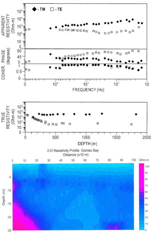
tric field) and Hx (x-component of magnetic field) are lined up with the profile line, and Ey and Hy are orthogonal to the profile direction (Fig. 2). Impedance tensors are retrieved from crosspower and autopower of four elements, Ex, Ey, Hx, and Hy, in MT time series (Bahr, 1988; Swift, 1986; Vozoff, 1991). Individual stations are examined by one-dimensional (1-D) inversion and modeling (Fig. 3) (Inman, 1975; Bostick, 1986). A two-dimensional (2-D) section (Fig. 4; line HJMT in Fig. 1) was constructed from the TM mode, inspected by EMAP filtering (Bostick, 1986; Smith and Booker, 1991;
Fig. 3. Apparent resistivity (top window), impedance phase (second), coherency (third), and true resistivity (bottom) of the data recorded at site HJMT-4. True resistivity is obtained by 1-D Bostick inversion. TM data are shown with solid rhomboid symbols while TE data are shown with open squares.
Fig. 4. A two-dimensional resistivity cross-section, constructed from TM mode (line HJMT in Fig. 1). Deep red colors (high electrical resistivity:
ρ> 100 Ohm-m) indicate unweathered basement rocks of granite (Jurassic) and volcanics (Cretaceous) and the basement deepens seaward; pale red colors (relatively high resistivity: 50
<ρ< 100 Ohm-m) indicate semi-con- solidated mud layer and weathered basement rocks; dark blue colors (low resistivity: ρ< 50 Ohm-m) represent tidal-flat deposits of mud, sand, and some gravels.
296 Woo Hun Ryang and Howoong Shon
Torres-Verdin and Bostick, 1992) and 1-D Bostick inver- sion. The EMAP technique is also used for the correction of apparent resistivity multiplied by an unknown frequency- independent factor, known as static shifts (Jones, 1988;
Torres-Verdin and Bostick, 1992). The IMAGEM survey using the high-frequency range does not conduct remote references for the removal of cultural-biased data but oper- ates the function of local self-references.
4. INTERPRETATION
In the HFMT profile, the area of high electrical resistivity (> 50 ohm-m in Fig. 4) is interpreted as weathered and unweathered basement rocks of granite (Jurassic) and vol- canics (Cretaceous) and tidal-flat/nonmarine strata experi- encing prolonged subaerial exposures. The low resistivity (< 50 ohm-m) is suggestive of tidal deposits (Holocene and Pleistocene). In the middle part (5−10 m deep), remarkably, the relatively high resistivity areas (50−100 ohm-m) extend seaward throughout the stratigraphic sections within a range of consistent subsurface depth (Fig. 4).
In Gomso Bay, the HFMT image is demarked by two dis- tinct discontinuities of resistivity differences (Figs. 4 and 5).
The lower one is interpreted as the boundary between the basement of high resistivity and the overlying Pleistocene tidal deposits (Unit III) of low resistivity. The upper one is expected to be a significant layer of tidal/nonmarine strata (Unit II), relatively high resistivity experiencing prolonged subaerial exposures, within the overlying Holocene tidal deposits (Unit I) of low resistivity.
5. DISCUSSION
In the studied area of Gomso Bay, there have been recent studies on a shelly sand ridge or chenier (Lee et al. 1994) and depositional environments or stratigraphy (Chang et al., 1996; Kim et al., 1999) using vibracores less than 5 m deep.
In this area, unfortunately, we have no deep-drilled cores (> 5 m in depth) for depth calibration and lithology interpre- tation of our HFMT data. The penetration depth of the HFMT image (Figs. 4, 5) was calculated using electrical resistivity and frequency (Fig. 3), considering the conductive survey environment.
In the Youngjongdo tidal flat, Kyunggi, Cheonsu, Hampyung, and Haenam bays and in other tidal-flat areas of the south- western Korea, the regional unconformities between the Pleistocene and Holocene tidal-flat successions were stud- ied based on several tens of vibracores, deep-drilled cores, and trench sections of tidal-flat deposits (e.g., Park et al., 1997b; Choi, 2001; Lim, 2001; Lim and Park, 2003). The upper units in these areas are commonly separated by an unconformity of a yellow semi-consolidated oxidized mud layer in the uppermost part of the deposits (Lim and Park, 2003). The semi-consolidated oxidized layer is present locally in variable depths but generally lies at a 5−20 m subsurface depth. It represents abundant evidence of sub- aerial exposure including yellowish colors, semi-consolida- tion, desiccation cracks, and cryoturbation structures (Lim and Park, 2003), authigenic siderites (Khim et al., 1999), and clay mineral compositions (Park et al., 1997a). In the off- shore seismic sections and deep-drilled cores of the Yellow Sea, the unconformity and semi-consolidated oxidized layers were also conformed (Jin et al., 2002; Jin and Chough, 2002). The stiffness in mud can be achieved by prolonged subaerial exposures in the upper intertidal to supratidal zones (Amos et al., 1988).
The firmground and stiff mud is characterized by rela- tively low porosity and permeability and the resultant high resistivity. As a result, the contrast of physical properties between the units probably shows up unconformity layers in the HFMT imaging profile (Figs. 4 and 5). An additional good point is that we need not worry about the anthropo- genic high-voltage electric noise during the HFMT probing in a tidal flat, unlike on land.
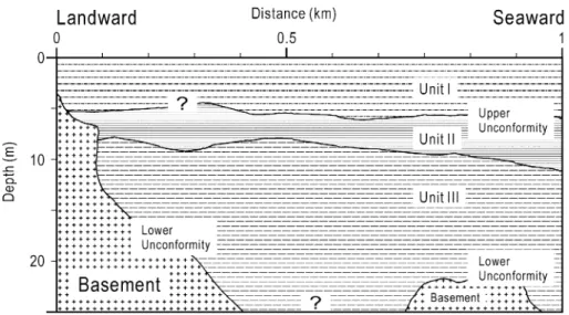
Fig. 5. A schematic diagram shows an interpreted aggradation section of three units and the basement. The lower unconformity is interpreted as a boundary between the basement and the overly- ing Pleistocene tidal deposits. The upper unconformity is expected to be a significant boundary between the tidal/
nonmarine strata experiencing pro- longed subaerial exposures and the over- lying Holocene tidal deposits.
Gomso Bay, the HFMT imaging shows a significant layer of relatively high resistivity within low resistivity deposits, which is indicative of nonmarine/tidal strata experiencing prolonged subaerial exposures within tidal successions.
ACKNOWLEDGMENTS: We are grateful to Drs. S. Lee (Elec- tromagnetic Instruments, Inc.), S.K. Chough (Seoul National Uni- versity), J.S. Kim (Chungbuk National University), H.R. Jo, H.J. Lee (KORDI), S.S. Chun (Chonnam National University), J.H. Jin (KIGAM), and Y.H. Kim for useful discussions on acquisition and interpretation of HFMT data.
REFERENCES
Amos, C.L., van Wagoner, N.A. and Daborn, G.R., 1988, The influence of subaerial exposure on the bulk properties of fine-grained inter- tidal sediment from Minas Basin, Bay of Fundy. Estuarine, Coastal and Shelf Science, 27, 1−13.
Bahr, K., 1988, Interpretation of the magnetotelluric impedance ten- sor: Regional induction and local telluric distortion. Journal of Geophysics, 62, 1−9.
Bostick, F.X., Jr., 1986. Electromagnetic array profiling. 56th Annual International Meeting of Society of Exploration and Geophysics (Expanded Abstracts), Houston, Texas, p. 60−61.
Cagniard, L., 1953, Basic theory of the magnetotelluric method of geophysical exploration. Geophysics, 18, 605−635.
Chang, J.H., Park, Y.A. and Han, S.J., 1996, Late Quaternary stratig- raphy and sea-level change in the tidal flat of Gomso Bay, west coast of Korea. Korean Society of Oceanography, The Sea, 1, 59−72. (in Korean with English abstract)
Choi, K.S., 2001, Late Quaternary Stratigraphy and Evolution of Tidal Deposits in Kyunggi Bay, West Coast of Korea. Ph.D. the- sis, Seoul National University, Seoul, 225 p.
Chough, S.K., 1983, Marine Geology of Korean Seas. International Human Resources Development Corporation Publishers, Boston, 157 p.
Chough, S.K., Lee, H.J. and Yoon, S.H., 2000, Marine Geology of Korean Seas. Elsevier, Amsterdam, 313 p.
Inman, J.R., 1975, Resistivity inversion with ridge regression. Geo- physics, 40, 798−817.
Jin, J.H. and Chough, S.K., 1998, Partitioning of transgressive depos- its in the southeastern Yellow Sea: a sequence stratigraphic inter- pretation. Marine Geology, 149, 79−92.
Jin, J.H. and Chough, S.K., 2002, Erosional shelf ridges in the mid- eastern Yellow Sea. Geo-Marine Letters, 21, 219−225.
Jin, J.H., Chough, S.K. and Ryang, W.H., 2002, Sequence aggrada- tion and systems tracts partitioning in the mid-eastern Yellow Sea:
roles of glacio-eustasy, subsidence and tidal dynamics. Marine Geology, 184, 249−271.
Jones, A.G., 1988, Static shift of magnetotelluric data and its removal in a sedimentary basin environment. Geophysics, 53, 967−978.
Jupp, D.L.B. and Vozoff, K., 1976, Discussion on the magnetotelluric method in the exploration of sedimentary basin. Geophysics, 41, 325−328.
transgressive stratigraphy of a macrotidal flat in the southeastern Yellow Sea: Gomso Bay, Korea. Journal of Sedimentary Research, 69, 328−337.
Kuznetzov, A.V., 1982, Distorting effects during electromagnetic sounding of horizontally non-uniform media using an artificial field source. Izvestiya, Earth Physics, 18, 130−137.
Lee, H.J., Chun, S.S., Chang, J.H. and Han, S.J., 1994, Landward migration of isolated shelly sand ridge (chenier) on the macrotidal flat of Gomso Bay, west coast of Korea: controls of storms and typhoon. Journal of Sedimentary Research, A64, 886−893.
Li, C., Chen, G., Yao, M. and Wang, P., 1991, The influences of sus- pended-load on the sedimentation in the coastal zones and con- tinental shelves of China. Marine Geology, 96, 341−352.
Lim, D.I., 2001, Late Quaternary Stratigraphy and Sedimentology of Tidal-flat Deposits, Western Coast of Korea. Ph.D. thesis, Seoul National University, Seoul, 303 p.
Lim, D.I. and Park, Y.A., 2003, Late Quaternary stratigraphy and evolution of a Korean tidal flat, Haenam Bay, southeastern Yel- low Sea, Korea. Marine Geology, 193, 177−194.
Marsset, T., Xia, D., Berne, S., Liu, Z., Bourillet, J.F. and Wang, K., 1996, Stratigraphy and sedimentary environments during the late Quaternary, in the Eastern Bohai Sea (North China Platform).
Marine Geology, 135, 97−114.
National Geography Institute, 1981, Basic research report on near- shore environments of Korea (Seokpo area). Seoul, 56 p.
Nichols, E.A., Morrison, H.F. and Lee, S., 1994, Controlled source magnetotellurics for groundwater. 64th Annual Meeting of Soci- ety of Exploration and Geophysics (Abstract), Los Angeles, Cal- ifornia, p. 553−554.
Palacky, G.J., 1987, Resistivity characteristics of geologic targets. In:
Nabighian, M.N. (ed)., Electromagnetic Methods in Applied Geophysics. Tulsa, Oklahoma, Society of Exploration and Geo- physics, 1, 53−129.
Park, Y.A., Choi, J.Y., Lim, D.I., Khim, B.K. and Hwang, S.Y., 1997a, Difference of clay mineral compositions between Holocene and Late Pleistocene tidal deposits in the Haenam Bay, Korea: evi- dence of subaerial exposure and weathering. Geosciences Jour- nal, 3, 138−144.
Park, Y.A., Lim, D.I., Choi, J.Y. and Lee, Y.G., 1997b, Late Qua- ternary stratigraphy of the tidal deposits in Hampyung Bay, southwest coast of Korea. Journal of Korean Society of Ocean- ography, The Sea, 2, 138−150. (in Korean with English abstract) Pirazzoli, P.A., 1991, World Atlas of Holocene Sea-Level Changes.
Elsevier, New York, 300 p.
Smith, J.T. and Booker, J.R., 1991, Rapid inversion of two- and three-dimensional magnetotelluric data. Journal of Geophysical Research, 96B3, 3905−3922.
Swift, C.M., 1967, A Magnetotelluric Investigation of an Electrical Conductivity Anomaly in the Southwestern United States. Ph.D.
thesis, Massachusetts Institute of Technology, 211 p.
Swift, C.M., 1986, A magnetotelluric investigation of an electrical conductivity anomaly in the southwestern United States. In: Vozoff, K. (ed.), Magnetotelluric Methods. Tulsa, Oklahoma, Society of Exploration and Geophysics, Reprint Series, 5, 156−171.
Torres-Verdin, C., 1991, Continuous Profiling of Magnetotelluric Fields.
Ph.D. thesis, University of California, Berkeley.
298 Woo Hun Ryang and Howoong Shon Torres-Verdin, C. and Bostick, F.X., Jr., 1992, Principles of spatial sur-
face electric field filtering in magnetotellurics: electromagnetic array profiling (EMAP). Geophysics, 57, 603−622.
Vozoff, K., 1972, The magnetotelluric method in the exploration of sedimentary basins. Geophysics 37, 98−141.
Vozoff, K., 1991, The magnetotelluric method. In: Nabighian, M.N.
(ed.), Electromagnetic Methods in Applied Geophysics. Tulsa, Oklahoma, Society of Exploration and Geophysics, 2B, 641−711.
Word, D. R., Smith, H. W. and Bostick, F. X., Jr., 1969, An inves- tigation of the magnetotelluric tensor impedance method. Elec-
trical Geophysical Research Laboratory Technical Report No. 82, University of Texas at Austin.
Zonge, K.L. and Huges, L.J., 1991, Controlled source audio-fre- quency magnetotellurics. In: Nabighian, M.N. (ed.), Electromag- netic Methods in Applied Geophysics. Tulsa, Oklahoma, Society of Exploration and Geophysics, 2B, 713−809.
Manuscript received August 20, 2003 Manuscript accepted November 25, 2003