산업기술연구(강원대학교 산업기술연구소 논문집), 제35권, 2015.
Journal of Industrial Technology, Kangwon Natl. Univ., Korea, No. 35, 2015.
- 55 -
도시화에 따른 하천의 변화탐지
- Dhobikhola, Kathmandu를 중심으로Temporal Change of River Shape due to Urbanization in Dhobikhola, Kathmandu
양 인 태* 아차르야 트리데브** 신 문 승***
Yang, In-Tae Acharya, Tri Dev Shin, Moon-Seung
Abstract
Natural shifting of rivers has been disturbed by anthropological activities.
Urbanization in Kathmandu has been encroached the natural floodplain of Bagmati and currently channeled by training walls. The study compares the change in shape of Dhobikhola, a small tributary using 1966 and 2014 satellite images. It has been found that the original shape is heavily changed over time at the beginning and end section of river under study. The river width is now fixed by training walls and roads along the banks. Using multiple data sets like satellite images and GIS analysis, these shifts can be easily detected to plan for management and restoration of physical and ecological behaviors of rivers.
키워드 : 도시화, 카트만두, 도비강, 구글어스, GIS
Keywords : Urbanization, Kathmandu, Dhobikhola Corona, Google Earth, GIS
1. Introduction1)
Rivers are flowing bodies of water. Naturally rivers follow winding path and are changing over time. In last centuries and in particular in the last decades, lots of rivers have experienced a significant channel alteration in response to various types of anthropological disruption such as land use changes, urbanization, channelization, dams, diversions, gravel and sand mining (Gregory 2006).
Urbanization started from 1970s onwards in
* 강원대학교 토목공학과 교수, 공학박사, 교신
저자
** 강원대학교 대학원 토목공학과 석박사통합과정
*** 강원대학교 대학원 토목공학과 박사과정
Kathmandu and is growing by 4% per year. It is one of the fastest growing cities in Asia and Pacific (ADB/ICIMOD, 2006). With its rapid haphazard urbanization, city hubs lacked open space, which has become a scarce resource with land prices increasing at high rate each year.
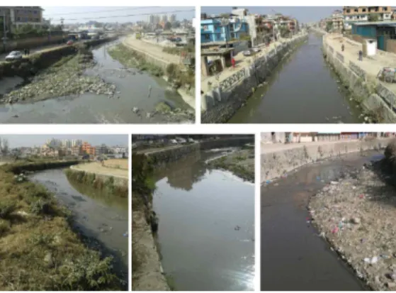
In lack of demarcation, Bagmati spines were the only open space left in some city core areas, the land has been encroached for various purposes like squatter settlements, residential, commercial, institutional developments, infrastructure development etc. (UN-Habitat, 2008). Recently, the government’s effort under Bagmati Action Plan(NTNC, 2009), has trained to make the river banks wider and deeper with stone walls and roads along the banks to serve urbanizing areas (Fig. 1).
산업기술연구(강원대학교 산업기술연구소 논문집), 제35권, 2015.
양 인 태, 아차르야 트리데브, 신 문 승
- 56 - Fig. 1 Current status of River and concrete
banks
The purpose of the study is to compare the change in Dhobikhola river floodplain over time using high resolution images from Corona and Google Earth.
2. Area of Study and Data
Fig. 2 Study area
The study area is a section of Dhobikhola River (Fig. 2), a tributary of Bagmati River inside Kathmandu Valley. The section under study is inside the Ringroad. It starts from the intersection of Ringroad and Dhobikhola at Gopikrishna area and ends by entering to main Bagmati River. It passes through densly populated area and is approximately 5.5 kms. in length. As most of the water of Bagmati is diverted for water supply, these tributaries are left with less fresh water and heavily polluted by untreated sewage. The water is grey in color and has foul smell too. Current effort of government to river management and cleaning is still in progress.
The data used in the study are satellite imageries available from USGS EarthExplorer and Google Earth. The oldest imagery used is from Corona acquired on 11th November 1966.
And latest images of Google Earth are from 21st October2003 and 5th January 2014.
3. M ethodology
The basis of the study is comparing the available satellite scenes from 1966 to 2014. First of all, the Panchromatic Corona image was obtained from USGS EarthExplorer. The image was geo-referenced and rectified to WGS 1984 UTM zone 45N based on the known landmarks and road cross-sections. The study area was clipped using ArcGIS to obtain the data for computing. Different texture maps were derived using MATLAB. Texture map helps in identifying the edges. Using the texture map and panchromatic images, polygon of the river were digitized.
Similarly, in Google Earth, the polygon of the river shape was digitized for 2003 and 2014. The digitized KML file were imported in ArcGIS and projected to the same scale geographic coordinate system. Lastly, layers were superimposed on one another for mapping change detection.
Methodology adapted here is illustrated in Fig 3.
산업기술연구(강원대학교 산업기술연구소 논문집), 제35권, 2015.
도시화에 따른 하천의 변화탐지 - Dhobikhola, Kathmandu를 중심으로
- 57 - Fig. 3 Flow Chart of the Study
Fig. 4(a). Corona Image 4(b). Standard Deviation Texture 4. Result and Discussion
The clipped texture image derived from the panchromatic Corona image is standard deviation. From the image, the edges were easily detectable and helpful in digitizing the river banks(Fig. 4).
After comparing with the Google Earth digitized vector layers in ArcGIS, it has been found that even in such a small tributary, huge
land has been encroached and converted in personal lands. The image from 1966 and other show much change in three sections, which can be seen in Fig 5. The River has shifted mostly in bends and has shown a complete change in course at the meeting point with Bagmati.
Fig. 5 Superimposed river shape during 1966, 2003 and 2014
In a report “Develop an Information Base and Strategies for Environmental Improvement of Bagmati River and its Territory” by UN-HABITAT(2008), it has been clearly stated that the river territory in 1964 cadastral maps were encroached and converted into private parcels in new 1986 cadastre.
Similarly, during the 2003 and 2014, it has been found that, illegal settling and construction activities had made the river a small channel.
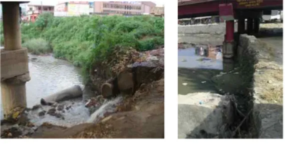
While following the Bagmati Action Plan 2009-2014 (NTNC, 2009), river training walls has been constructed to channelize the river water wide and roads along the banks to serve urbanizing areas. Hence, the river has been widen again in 2014 compared to 2003. Some of the changes in the river channel can be seen in the following Fig 6. and 7.
산업기술연구(강원대학교 산업기술연구소 논문집), 제35권, 2015.
양 인 태, 아차르야 트리데브, 신 문 승
- 58 - Fig. 6 Change in river bank under Chabhail
Ringroad Bridge. (2005 and 2014)
Fig. 7 River section before and after the river management at Kalopul (2005 and 2014) 5. C onclusion
Rapid and uncontrolled infrastructure development works along with many other problems have posed maximum threats to the natural water body. Freely available satellite images like Corona and open source like Google Earth can be a good source to understand the changes of some rivers. It has been concluded that using multiple data sources and GIS techniques, river shape shift can be studied and can be used to plan for the management and restoration of physical and ecological behaviors of rivers.
References
[1] ADB/ICIMOD, Asian Development Bank/International Centre for Integrated Mountain Development, Environment Assessment of Nepal: Emerging Issues and Challenges, ADB, Kathmandu, pp.81, 2006.
[2] NTNC, National Trust for Nature Conservation (2009), Bagmati Action Plan (2009-2014). Govt. of Nepal, High Powered Committee for Integrated Development of the Bagmati Civilization and National Trust for Nature Conservation, Kathmandu, http://www.ncf.org.np/upload/files/1132_en_1 310646546bagmati_action_plan.pdf (last date accessed: 19 November 2014)
[3] Gregory, K. J., “The human role in changing river channels”, Geomorphology, 79(3), pp.172-191, 2006.
[4] UN-Habitat, United Nations Human Settlements Programme (2008), Develop an Information Base and Strategies for Environmental Improvement of Bagmati
River and its Territory,
http://www.unwac.org/pdf/publications/bagm ati_1.pdf (last date accessed: 19 November 2014)