Steric Sea Level Variability in the East Asian Seas estimated from Ocean Reanalysis Intercomparison Project Data
You-Soon Chang* and Min-Ji Kang
Department of Earth Science Education, Kongju National University, Kongju 32588, Korea
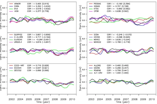
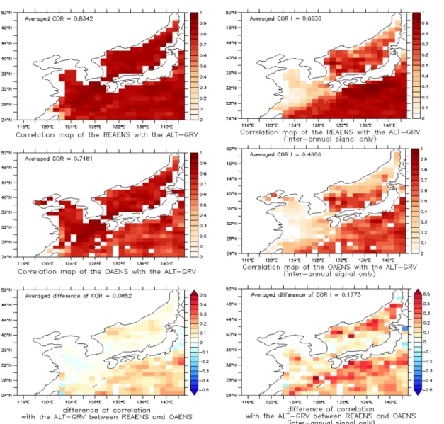
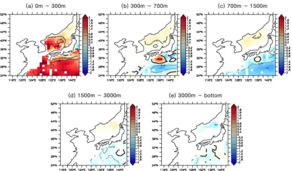
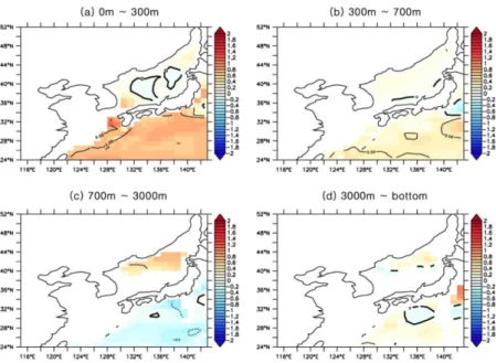
Abstract: In this study, steric height variability in the East Asian Seas (EAS) has been analyzed by using ocean reanalysis intercomparison project (ORA-IP) data. Results show that there are significant correlations between ocean reanalysis and satellite data except the phase of annual cycle and interannual signals of the Yellow Sea. Reanalysis ensemble derived from 15-different assimilation systems depicts higher correlation (0.706) than objective analysis ensemble (0.296) in the EAS. This correlation coefficient is also much higher than that of the global ocean (0.441). For the long- term variability of the thermosteric sea level during 1993-2010, a significant warming trend is found in the East/Japan Sea, while cooling trend is shown around the Kuroshio extension area. For the halosteric sea level, a dominant freshening trend is found in the EAS. However, below 300 m depth around this area, the signal-to-noise ratio of the linear trend is generally less than one, which is related to the low density of observation data.
Keywords: steric height, ocean reanalysis, East Asian Seas, objective analysis, thermosteric, halosteric
Introduction
According to the assessment report version 5 (AR5) of the Intergovernmental Panel on Climate Change (IPCC), one of the major harmful factors to the human society is the sea level rise associated with the global warming. Annual mean sea level rise on a global scale is estimated as 1.7±2 mm/year for 1901- 2010 and 3.2±4 mm/year for 1993-2010 (IPCC, 2014).
However, large uncertainties remain for the regional scale sea level budget (Chang et al., 2010; Chang, 2012).
Sea level rise in the East Asian Seas (hereafter EAS) is very vulnerable to climate change by monsoons, El Nino, and other major climate signals (Pacific Decadal Oscillation (PDO), Arctic Oscillation (AO), and so on) (Lee et al., 2012; Chang and Shin, 2014). Therefore, it is very important to continuously investigate sea level rise associated with oceanic
variability. While sea level change may have different causes, regional sea level rise is generally dominated by the steric component (Fukumori and Wang, 2013).
Steric height is calculated by the density change associated with water temperature and salinity change.
If we consider temperature (salinity) contribution only, it is called as thermosteric (halosteric) height (Tabata et al., 1986; Levitus et al., 2005).
Objective analyzed (OA) and reanalysis (REA) data have been used to investigate the global or regional mean steric height change because oceanic observing system is very rare in the global ocean for the long time. OA data are interpolated products with in situ observations usually blended with climatology, or a persistence background fields (Ishii et al., 2006;
Chang, 2012; Levitus et al., 2012). They are relatively simple and computationally less expensive, but they do not guarantee any dynamic process of the ocean and strongly depend on the correlation function during the interpolation process. OA data can also be unrealistically close to the climatology fields especially in the data sparse regions. An alternative method is the oceanic reanalysis based on the data assimilation model. However, REA data also have chronic limitation due to inaccurate numerical models associated with sensitive initial/boundary conditions, imperfect assimilation
*Corresponding author: [email protected]
*Tel: +82-41-850-8292
This is an Open-Access article distributed under the terms of the Creative Commons Attribution Non-Commercial License (http://
creativecommons.org/licenses/by-nc/3.0) which permits unrestricted
non-commercial use, distribution, and reproduction in any medium,
provided the original work is properly cited.
methods, and the nonlinearity of nature. Therefore, continuous efforts need to be necessary for the intercomparison of various OA and REA data.
Recently, many attempts have been devoted to the assessment of OA and REA data, which have now reached some degree of maturity (Lee et al., 2009).
With the same purpose, Ocean Reanalysis Intercomparison Project (ORA-IP) was successfully coordinated (Chang, 2015; Balmaseda et al., 2015). Important 8 different oceanic variables (steric height, heat content, sea surface height, surface heat flux, mixed layer depth, salinity change, 20
oC isothermal depth, sea ice content) have already been validated. However, very limited numbers of studies for the evaluation of OA or REA data around the EAS have been published (Chang, 2012; Seo et al., 2015; Han et al., 2016; Sim et al., 2018; Lee et al., 2018).
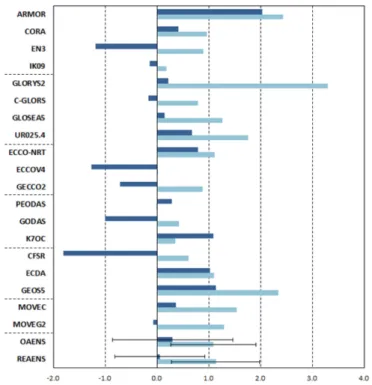
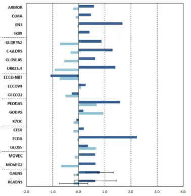
Storoto et al. (2017) published a comprehensive evaluation of the steric sea level variability from ORA-IP data in the global ocean. They initially generated ensemble means of 16 REA and 4 OA, and compared them with a satellite-derived (altimetry minus gravimetry) steric height for a short period (2003-2010). Extended periods (1993-2010) were also analyzed for the interannual trends of global steric sea level. In this study, we intentionally follow their configuration by selecting same analysis method and periods expect for the study area, EAS. We expect that this consistent configuration with previous study leads to an effective comparison between global and regional characteristics of ORA-IP products.
This study is organized as follows. Section 2 describes the data and methods used in this study, and results are followed in section 3. A comparison against reference steric sea level estimated from satellite data for a short period (2003-2010) is present. Another intercomparison is extended to the 1993-2010 period for analyzing long-term steric change. Finally, the main summary and conclusion are given in the last section 4.
Data and Methods
Ocean reanalysis intercomparison project ORA-IP was suggested and agreed at the Climate and Ocean Variability, Predictability, and Change (CLIVAR)/Global Synthesis and Observations Panel (GSOP) meeting held at Woods Hole Oceanographic Institution (WHOI) in 2012, and European Centre for Medium-Range Weather Forecasts (ECMWF) in 2013.
There are two different working groups of the ORA- IP. One is the data producing group and the other is the data processing group. Total 26 different products have participated this project. Six of them are objective analysis data, and twenty of them are assimilation data.
Table 1 is the summarized information about product name, model information (base model, resolution, and assimilation method), and product institute for each ORA-IP data used in this study. It includes not only assimilation model data, but also OA data. Fifteen of them are REA including four coupled data assimilation systems (CFSR by NOAA/NCEP, ECDA by NOAA/
GFDL, GEOS5 by NASA/GMAO, and MOVEC by MRI/JMA).
Validation data
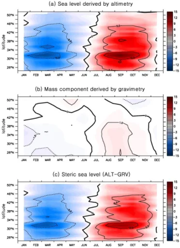
For the validation, this study used two satellite datasets representing total and mass component of sea level. The total sea level roughly equals to the summation of the sea level change by the density and mass. Each sea level component can be observed by different observation platforms (Cazenave and Llovel., 2010; Chang et al., 2010; Church et al., 2011; Chang, 2014). If we have two satellite platforms providing total and mass component of sea level, we can simply estimate satellite-based steric component by subtracting mass component from total component of sea level.
This satellite-based steric data can be used to evaluate
steric height based on temperature and salinity data of
ORA-IP products. Therefore, this study used two
satellite data (Archiving, Validation and Interpretation of Satellite Oceanographic data (AVISO) is for the total sea level, and Gravity Recovery and Climate Experiment (GRACE) Tellus is for the mass sea level).
For the total sea level, satellite altimeter gridded data from the Jason-1 measurements distributed by AVISO have been used, that is the monthly mean delayed time version on 1/4
oby 1/4
ogrid point. We converted them to 1
oby 1
oin the EAS from 2003 to 2010 for the comparison with ORA-IP data. For the mass component of sea level, we used monthly mean RL04 version on 1
oby 1
ogridded GRACE data provided by Center for Space Research, University of Texas (CSR) and GeoForschungsZentrum, the German Research Centre for Geosciences (GFZ). GRACE is a twin satellite system and it is used to make gravitational field measurement by estimating the changes in the distance between the twin satellites. However, it is known that mass variation in the ocean measured by the GRACE satellite is vulnerable to leakage of land hydrologic signals and their magnitudes are larger than
the real ocean signals (Chambers, 2006; Chang et al., 2010; Leuliette and Willis, 2011). The GRACE Tellus used in this study made an effort to remove the hydrologic signals, but possible land contamination of oceanic signals may remain especially on the reginal scale. In this study, we do not address steric sea level uncertainties from the gravimetric data errors, as it is beyond the scope of this work. Two different datasets have been averaged in the EAS for 2003-2010. By subtracting gridded GRACE data from AVISO data (hereafter ALT-GRV), we can obtain satellite-based steric component for the validation of ORA-IP.
Methods
Steric sea level component ( η
s) approximately consists of thermosteric (η
t) and halosteric (η
h) sea level components:
where the ρ is the ocean density that is the function η
s≅ η
t+ η
hρ T S ( , )
ρ
0---dz
H –
∫
0– ρ T S ( , )
ρ
0---dz
H –