Received |
30 July, 2019
Revised |9 August, 2019
Accepted |31 December, 2019
OPEN ACCESS
This is an Open-Access article distributed under the terms of the Creative Commons Attribution Non-Commercial License (http://creativecommons.
org/licenses/by-nc/4.0) which permits unrestricted noncommercial use, distribution, and reproduction
ABSTRACT
Purpose: In this studies we examine the facilities damage characteristics caused by forest fire.
Therefore, we surveyed damaged facilities from forest fire which was occurred on Goseong-Gun on march 28 in 2019.(damaged areas was 40ha) The types of facilities uses were house, public facility, warehouse and so on. 17 facilities were destroyed. The purpose of this study was to for establishing a disaster safety village in rural areas where damage from a similar type of disaster occurs repeatedly by conducting the consciousness survey targeting at experts and disaster safety officials in a local government. Method: We surveyed meteorological factors(temperature, wind speed, wind direction, humidity) per a minute for analyzing weather condition on Goseong-Gun when forest fire was occurred, spread and extinguished. And we surveyed forest fire risk factors(a slope degree, a slope direction, a geographical feature, a distance between forest and facility, main species, the existence of crown fire ignition, the direction of facility, the main material of building) around 10 damaged facilities. Finally, we analyzed damage pattern of facilities using meteorological factor and forest fire reisk fator Result:
The weather condition of Kanseonng AWS (No.517) was high temperature , arid and strong wind, when the forest fire was occurred and spread. An average wind speed was 4.1m/s and the maximum wind speed was 11.6m/s. The main direction of wind was W(225 ∼315°). Damaged facilities were located on the steep slope area and on the mountaintop. The forest density around facilities was high and main species was korean red pine. The crown fire was occurred in the forest around damaged facilities. The average distance was 13.5m from forest to facilities. When the main matarial of building was made by fire resistance materials (for example, rainforced concrete), the damage was slightly. on the other hand, when by flammable material (for example, a Sandwich Panel), the facilities were totally destroyed Conclusion: The results of this research which were the thinning around house, making a safety distance, the improvement of main material of building and etc, will be helpful for establishing a counter measure for a forest fire prevention of facilities in wild land urban interface
Keywords: Frest fire, Goseong-Gun, weather, facility damage, The main material of building
KOSDI www.sodi.or.kr https://doi.org/10.15683/kosdi.2019.12.31.469
Original Article
고성산불로 인한 시설물피해특성 연구
A Study on Facilities Damage Characteristics Caused by Forest Fire in Goseong-Gun
염찬호
1ㆍ이시영
2*ㆍ박흥석
3ㆍ권춘근
4Chanho Yeom
1, Si-young Lee
2*, Houngsek Park
3, Chungeun Kwon
41
Researcher, Professional Graduate School of Disaster Prevention, Kangwon National University, Samcheok, Republic of Korea
2
Professor, Department of Fire & Social Disaster Prevention, Kangwon National University, Samcheok, Republic of Korea
3
Researcher, Dongguk University Graduate school of forestry, Seoul, Republic of Korea
4
Junior Researcher, National Institute of Forest Science, Seoul, Republic of Korea
*Corresponding author: Si-young Lee, [email protected]
성산불은 산림 및 농작물 피해는 물론이고, 사람이 거주하는 주택, 공공시설, 창고, 군사시설 등 17건의 시설물에 피해를 주었다. 본 연구의 목적은 이 피해 시설물들의 세부적인 피해원인을 분석하여, 산림인접 시설물들에 대한 산불피해 방지 방안을 제시하기 위하여 수행하였다.
연구방법: 고성산불발생시 기상을 분석하기 위해 산불발생과 진화완료시(2018.3.28 06:19 ∼ 22:00)의 기상상황(기온, 풍속, 풍향, 습도)을 1 분단위로 분석하였고, 시설물 피해 사례조사를 위해 고성산불로 인해 발생한 17건의 시설물 중 군사시설 등을 제외한 10건의 피해 시설물 주 변의 경사도, 사면향, 지세특성, 산림과의 이격거리, 주요수종, 수관화발생 유무, 주택방위, 주택재질 등 9개 항목에 대한 현장조사를 실시하 여 산불피해특성을 분석하였다. 연구결과: 고성산불 발생과 진화완료시(2018.3.28 06:19 ∼ 22:00)의 기상상황(간성 517AWS)은 기온 및 습 도가 고온 건조한 상태였으며, 풍속은 평균 4.1m/s, 최대 11.6m/s의 강한 바람이 불었다. 주풍향은 W(225∼315°)방향이었으며, 산불의 확산 방향과 일치하였다. 또한 산불피해 시설물들은 급경사지와 능선의 산정부에 위치하였고, 시설물주변 산림은 수관화 발생지역의 소나무 밀 임분 지역이었다. 산림과 시설물과의 이격거리는 평균 13.5m이었으며, 시설물의 재질이 불에 강한 콘크리트였을 경우 경미한 피해를 입었 지만, 샌드위치판넬 등 산불에 약한 재질은 모두 전소한 것으로 나타났다. 결론: 본 연구를 통해 얻은 결과인 주택주변의 숲 가꾸기 실시와 이 격거리 확보, 시설물들의 불연재 재질로의 개선 등을 통해 산림인접 시설물들에 대한 산불방지 대책수립에 기여 할 것으로 기대된다.
핵심용어: 산불, 고성군, 기상, 시설물피해, 시설물 재질
서 론
우리나라의 산불은 최근 10년간(2009∼2018년) 총 4,316건(면적 6,699ha)에 연평균 432건(면적 670ha)이 발생하고 있으 며, 최근에는 기후변화 등의 원인으로 전세계적으로도 초대형 산불이 자주 발생하여 산불예방과 방지가 국제적 이슈로 부각 되고 있다(Korea Forest Service, 2019). 산림청에서 발간한 ‘산불통계분석을 통한 산불정책 변천 및 대응 방안’ 보고서에 의 하면, 전 세계적인 기후변화의 영향으로 산불이 더욱 대형화하고 빈발할 것으로 예상하고 있다(Korea Forest Service, 2011).
또한, 선진국에서부터 개발도상국까지 최근 인구 증가와 인구의 도시 집중에 따른 도시의 확장으로 인해, 기존 도시지역 과 인접한 외곽 산림과 녹지는 도시로 편입하여, 거주지와 상업지로 개발하여 왔다. 과거 이러한 지역은 개발 시 산림을 모두 제거한 뒤 개발하였으나, 최근 환경의 중요성이 높아지면서 산림과 녹지를 보존하며 개발하고 있다. 이러한 녹지대는 거주민 의 건강, 경관을 위해 쾌적한 환경을 제공하게 되지만, 도시에서 발생한 화재가 산불로 전이되거나, 산불이 도시의 건물로 쉽 게 옮기게 하는 매개체가 되고 있다(Park et al., 2012). 미국 등 도시화의 역사가 오래된 국가에서는 이런 지역에서의 산불 발 생과 그 피해에 주목하여 연구를 진행해오고 있으며, 야생지-도시 경계화재(WUI : WIldland-Urban interface fire)이라고 하 여 별도로 관리를 하고 있다(Randeloff, 2005; Cohen, 2008; 2010).
우리나라에서 발생한 고성산불(1996), 동해안 산불(2000), 청양ㆍ예산 산불(2002), 양양산불(2005), 포항산불(2013), 울 주산불(2013), 삼척산불(2017), 강릉산불(2017), 고성/속초산불(2018) 등은 산림 내에 많은 시설 및 산림 내의 많은 재산피 해는 물론, 특히 송이 산지 및 문화재 등의 소실로 인해 많은 사회경제적 피해를 가져왔던 사례라고 할 수 있다. 그동안 겪은 산림 내의 주요 산불 피해로는 농작물, 농업시설물, 축사, 가축, 축산기자재, 사료, 송이, 군사시설, 도로, 송전시설, 통신시설, 전력, 상수도, 사찰, 문화재 등 직접피해와 산림생태 환경 등의 피해 등 간접피해가 있었다. 특히, 산림 내에는 사찰과 같은 중 요 문화재와 송전탑, 통신선로와 같은 사회기반시설, 요양원과 같은 다중 이용 시설 등이 있어, 산불 발생 시 그 직접적 피해 와 간접적 피해가 크며, 산림이라는 위치적 특성으로 인해, 단시간 동안 대형 피해를 야기할 가능성이 크다고 할 수 있다 (Kwon et al., 2013; Yeom et al., 2013; Yeom, 2019).
따라서, 본 연구의 목적은 이 피해 시설물들의 세부적인 피해원인을 분석하여, 산림인접 시설물들에 대한 산불피해 방지 방안을 제시하기 위하여 수행하였다.
연구내용 및 방법
연구내용
본 연구는 산불로 인한 시설물피해 특성연구를 위하여 2018년 3월 28일 강원도 고성군 간성읍 탑동리 산16(야산)에서 발 생한 산불(피해면적 40ha)을 대상으로 시설물피해 현황을 조사하였다. 고성산불은 산림 및 농작물 피해는 물론이고, 사람이 거주하는 주택, 공공시설, 창고, 군사시설 등 17건의 시설물 피해를 주었다. 따라서 이 피해 시설물들의 세부적인 피해원인을 분석하여, 산림인접 시설물들에 대한 산불피해 방지 방안을 제시하였다.
연구방법
산불피해지 기상요소 현황분석
고성산불 발생과 진화완료시(2018.3.28 06:19 ∼ 22:00)의 기상상황(기온, 풍속, 풍향, 습도)을 강원도 고성군 간성읍 신 안리에 위치한 간성 517AWS(자동기상관측장치)의 기상데이터를 1분단위로 분석하였다.
시설물피해 사례조사 분석
고성산불로 인해 발생한 17건의 피해 시설물 중 군사시설 등을 제외한 10건에 대하여 경사도, 사면향, 지세특성, 산림과의 이격거리, 주요수종, 수관화발생 유무, 주택방위, 주택재질 등 9개 항목에 대한 현장조사를 실시하여 산불피해특성을 분석하 였다.
연구수행 결과
산불피해지 기상요소 현황분석
고성산불 발생과 진화완료시(2018.3.28 06:19 ∼ 22:00)의 기상상황을 분석하였다.
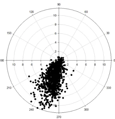
고성산불 피해지와 약 1km에 위치한 강원도 고성군 간성읍 신안리 간성 517AWS(자동기상관측장치)의 기상자료를 1분 단위로 측정한 961건의 기상요소(기온, 습도, 풍송, 풍향)를 분석한 결과는 Table 1 및 Fig. 1에서와 같이 최고기온 22.7℃, 최 소습도 31%의 고온 건조한 상태였으며, 풍속은 평균 4.1m/s, 최대 11.6m/s의 강한 바람이 불었으며, 주풍향은 W(225∼
315°)인 것으로 조사되었다. 즉, 서풍계열의 고온 건조한 강한바람으로 인해 산불은 남서쪽 방향에서 북동쪽 방향으로 진행 하였고, 강한 바람으로 인해 산불의 형태는 좁고 긴 타원형으로 나타났다.
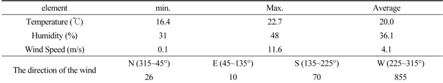
Table 1.
The results of the survey of meteorological element on Kanseong AWS(No.517)element min. Max. Average
Temperature (℃) 16.4 22.7 20.0
Humidity (%) 31 48 36.1
Wind Speed (m/s) 0.1 11.6 4.1
The direction of the wind N (315~45°) E (45~135°) S (135~225°) W (225~315°)
26 10 70 855
Fig. 1. The results of the survey on the wind direction on Kanseong AWS (No.517)
주택피해 사례조사 분석
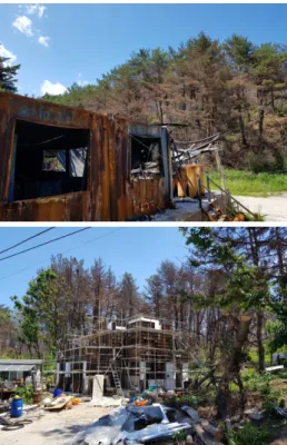
고성산불로 인해 피해를 입은 10건 시설물의 경사도, 사면향, 지세특성, 산림과의 이격거리, 주요수종, 수관화발생 유무, 주택방위, 주택재질 등 9개 항목에 대한 현장조사를 실시하여 산불피해특성을 조사하였다. Table 2는 고성산불 시설물피해 현황을 종합한 결과이며, Figs. 2, 3은 서풍계열의 산불진행 방향으로 인해 피해를 입은 시설물들은 나타낸 것이다.
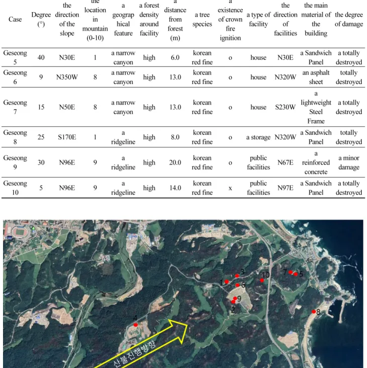
Table 2. The results of the survey on damaged facilities from Goseong forest fire
Case Degree (°)
the direction
of the slope
the location
in mountain
(0-10) a geograp
hical feature
a forest density around facility
a distance
from forest (m)
a tree species
a existence of crown
fire ignition
a type of facility
the direction
of facilities
the main material of
the building
the degree of damage
Geseong
1 5 N65E 9 a
ridgeline high 10.0 korean
red fine o house N65E a Sandwich Panel
a totally destroyed Geseong
2 30 N97E 9 a
ridgeline high 40.0 korean
red fine o public facilities N67E
a reinforced
concrete
a minor damage Geseong
3 46 S160E 1 a
ridgeline high 3.0 korean
red fine o house S180 a Sandwich Panel
a totally destroyed Geseong
4 3 N10E 10 a
ridgeline high 8.0 korean
red fine o house N10E a Sandwich Panel
a totally
destroyed
Fig. 2. the spread direction of the forest fire and locations of surveyed facilities (the source: google earth) Table 2. Continued
Case Degree (°)
the direction
of the slope
the location
in mountain
(0-10) a geograp
hical feature
a forest density around facility
a distance
from forest (m)
a tree species
a existence of crown
fire ignition
a type of facility
the direction
of facilities
the main material of
the building
the degree of damage
Geseong
5 40 N30E 1 a narrow
canyon high 6.0 korean
red fine o house N30E a Sandwich Panel
a totally destroyed Geseong
6 9 N350W 8 a narrow
canyon high 13.0 korean
red fine o house N320W an asphalt sheet
totally destroyed
Geseong
7 15 N50E 8 a narrow
canyon high 13.0 korean
red fine o house S230W
a lightweight
Steel Frame
a totally destroyed
Geseong
8 25 S170E 1 a
ridgeline high 8.0 korean
red fine o a storage N320W a Sandwich Panel
totally destroyed Geseong
9 30 N96E 9 a
ridgeline high 20.0 korean
red fine o public facilities N67E
a reinforced
concrete
a minor damage Geseong
10 5 N96E 9 a
ridgeline high 14.0 korean
red fine x public
facilities N97E a Sandwich Panel
a totally
destroyed
Fig. 3. Damaged facilities from Goseong forest fire
산림인접 시설물주변 지형조사 분석
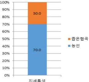
산림인접 시설물주변 경사는 Fig. 4와 같이 절험지(40°이상) 20.0%, 험준지(30~40°) 20.0%, 급경사지(20~30°) 10.0%, 완 경사지(5~15°) 10.0%로 조사되었으며, 50%가 급경사지 이상에 위치하고 있는 것으로 조사되었다. 경사가 급할수록 산불피 해가 발생할 확률이 높다는 연구결과와 일치하였으며(Korea Forest Research Institute, 2011), 또한, 20°미만의 경사지에 위 차한 시설물들은 대부분 산정부에 위치하여 피해를 입은 것으로 판단되었다. 사면향은 Fig. 5와 같이 남향사면이 50%, 북향사 면이 50%였고, 지세특성은 Fig. 6과 같이 능선이 70.0%, 좁은협곡이 30.0%으로 능선지역이 대부분인 것으로 분석되었다.
Fig. 4. The results of analysis in the slope
Fig. 5. The results of analysis in the direction of slope Fig. 6. The results of analysis in the geographical feature
산림인접 시설물주변 산림특성 분석
산림인접 시설물주변 산림은 Fig. 7과 같이 모두 밀임분 이었다. 이는 산불 발생 시 피해 확률이 높은 것으로 조사되었다 (Korea Forest Research Institute, 2012).
시설물과의 이격거리는 Fig. 8과 같이 10m 미만 40%, 10m 이상 60%로 조사되었고, 평균 이격거리는 13.5m인 것으로 나 타났다. 산림과의 거리가 10m 이내일 경우 피해를 입을 확률이 높으므로(Korea Forest Service, 2007) 시설물과 산림과의 이 격거리를 확보하는 것이 좋을 것으로 사료되었다.
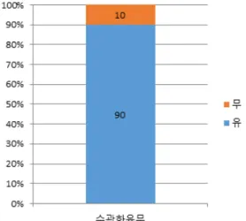
산림인접 주택주변 주요수종은 Fig. 9와 같이 소나무가 100%로 조사되었고, Fig. 10과 같이 90%가 수관화 피해를 입은 것으로 조사되었다. 이러한 침엽수는 산불의 발화와 확산조건을 충족시키기 때문에 산불발생 시 피해 확률이 높은 것으로 분 석되었다(Korea Forest Service, 2011).
Fig. 7. The results of analysis on the forest density Fig. 8. The results of analysis on the distance from forest
Fig. 9. The results of analysis on the distance from forest Fig. 10. The results of analysis on the existence of a crown fire
ignition산림인접 시설물 방향 및 재질특석 분석
산림인접 주택방위는 Fig. 11과 같이 남향사면 50%, 북향사면 50%였으나 북향사면의 경우 능선의 산정부에 위치하고 있 어 피해를 입었다. 또한, Fig. 12와 같이 시설물의 재질은 불에 약한 샌드위치판넬(전소)이 60%로 가장 많았고, 철근콘크리 트(경미한 피해) 20%, 아스팔트싱글(전소) 10%, 경량철골조(전소) 10%의 피해를 입었다. 시설물의 재질이 불에 강한 콘크 리트였을 경우 경미한 피해를 입었지만 불에 약한 재질은 모두 전소한 것으로 분석되었다.
Fig. 11. The results of analysis on the direction of houses Fig. 12. The results of analysis on the main material of buildings
결 론
2018년 3월 28일 06:19에 발생한 강원도 고성산불은 산림피해 뿐만아니라 사람이 거주하는 주택, 공공시설, 창고, 군사시 설 등 17건의 시설물에 피해를 주었다. 따라서 본 연구는 이 피해 시설물들의 세부적인 피해원인을 분석하여, 산림인접 시설
물들에 대한 산불피해 방지 방안을 제시하기 위하여 수행하였으며, 주요 연구결과는 다음과 같다.
첫째, 고성산불 발생과 진화완료시(2018.3.28 06:19 ∼ 22:00)의 기상상황(간성 517AWS)은 최고기온 22.7℃, 최소습도 31%의 고온 건조한 상태였으며, 풍속은 평균 4.1m/s, 최대 11.6m/s의 강한 바람이 불었으며, 주풍향은 W(225∼315°)으로 산불의 확산 방향과 일치하여 빠른 산불확산과 함께 시설물들에 많은 피해를 주었다.
둘째, 고성산불로 인해 피해를 입은 10채 시설물들의 50%이상이 급경사지 산림주변이었으며, 특히 능선의 산정부에 위치 했을 경우 피해를 더 입은 것으로 나타났다.
셋째, 산림인접 시설물주변 산림은 모두 밀임분 이었고, 시설물과의 이격거리는 평균 13.5m이었으며, 주요수종은 소나무 림(100%)으로 나타났고, 90%가 수관화 피해를 입은 것으로 조사되었다. 시설물들의 재질은 불에 약한 샌드위치판넬(전소) 이 60%로 가장 많았고, 철근콘크리트(경미한 피해) 20%, 아스팔트싱글(전소) 10%, 경량철골조(전소) 10%의 피해를 입었 다. 시설물의 재질이 불에 강한 콘크리트였을 경우 경미한 피해를 입었지만, 불에 약한 재질은 모두 전소한 것으로 나타났다.
따라서, 산림인접 시설물들의 경우 주변 산림의 숲 가꾸기와 이격거리 확보, 시설물의 불연재료로의 재질개선 등을 통해 산불로부터 피해를 줄일 수 있을 것으로 기대된다.
Acknowledgment
이 논문은 2019년도 정부(과학기술정보통신부)의 재원으로 정보통신기술진흥센터의 지원을 받아 수행된 연구임 (No.2018-0-01456, 지능 기반 초소형 Disposable IoT 동적 자율 구성 및 실행 인프라 기술).
References
[1] Cohen, J. (2008). “The wildland-urban interface fire problem: A consequence of the fire exclusion paradigm.”
Forest history today, Fall, pp. 20-26.
[2] Cohen, J. (2010). “The wildland-urban interface fire problem.” FREMONTIA, Vol. 38, No. 2-3, pp. 17-22.
[3] Korea Forest Service (2019). 2018 Forest Fire Annual Statistical Report, Korea Forest Service, pp. 1-261.
[4] Kwon, C.-G., Lee, S.-Y., Yeom, C.-H., Park, H.-S. (2013). “The analysis of damage characteristics of facility caused by the Forest fire on Pohang.” Transactions of Korean Institute of Fire Science and Engineering, p. 199.
[5] Lee. S.-Y., Jeon, G.-W., Jeon, K.-W., Lee, M.-W., Chae, H.-M., Kim, M.-S., Lee, H.-J., Kim, Y.-J., You, H.-G., Park, J.-H. (2007). Effect of the leaving of Thinning slash on forest disaster. Korea Forest Service, pp. 73-143.
[6] Lee. S.-Y., Yoon, H.-Y., Lee, M.-W., Lee, H.-S., Park. H.-S., Sung, J.-K., Kwon, C.-G., Jeon, S.-Y. (2010). New Policy Changes and Response Measures through Forest Fire Statistical Analysis, Korea Forest Service, pp. 1-185.
[7] Lee. S.-Y., Yoon, H.-Y., Lee, M.-W., Lee, H.-S., Park. H.-S., Sung, J.-K., Kwon, C.-G., Jeon, S.-Y. (2011). A Proposal for Estimating the Disparity Distance by Forest Land Facilities, Korea Forest Research Institute, pp. 37-45.
[8] Lee, S.-Y., Park. H.-S., Kwon, C.-G., Yeom, C.-H. (2012). Development of Forest Risk Assessment Technique for Forest Land, Korea Forest Research Institute, pp. 37-50.
[9] Park, H.S., Lee, S.-Y., Lee, B. (2012). “Questionnaire Concerning the Actual State of Forest Fire Danger for Facilities in Wildland-urban Interface in Gyeongbuk 3 Province.” Journal of Korean Society of Hazard Mitigation, Vol. 12, No. 3, pp. 203-210.
[10] Randeloff, V.C., Hammer, R.B., Stewert, S.I., Fried, J.S., Holcomb, S. S., McKeefry, J.F. (2005). “The Wildland-
Urban Interface in the United States.” Ecological Applications, Vol. 15, No. 3, pp. 799-805.
[11] Yeom, C.-H., Lee, S.-Y., Kwon, C.-G., Park. H.-S. (2013). “The analysis of damage characteristics of facility caused by the Forest fire on Uljoo-Gun.” Transactions of Korean Institute of Fire Science and Engineering, p. 210.
[12] Yeom, C.-H. (2019). A Study on prevention of Forest Fires of Adjacent Forest Facilities. Doctor of Engineering.
Department of Disaster Prevention Graduate School of Disaster Prevention, Kangwon National University, pp. 1-2.