1. Introduction
1) Background
Geographic information system had started from aerial photography in a broad sense, imagery is still a great input tool to geospatial industry and geo-sciences (Coops and Tooke, 2017). The platforms to bear sensors have expanded with diversification in drones, satellites, helicopters and airplanes. Sensors become more affordable and available from special research groups to the general public and civil communities. Software to manipulate images become one of the scientific application services on the fly. When anyone buys a
drone, ortho-photography can be generated in the server of the data via private telecommunication beyond political boundaries.
ISO TC/211 have been developed and updated many standards for the image and gridded data in Working Group 6 for more than 25 years, but the number of standards on that is limited to ten. Implementation of standards, on the other have been suggested by Open Geospatial Consortium. However, system integrators have not adopted such standards, though abstract test suites in the standards are not applicable. Some of the classes or codes in the standards have been selected to create the regulations and documentation of image
Applying Standards of Image Quality:
Issues and Strategies
Eunmi Chang
1)†· Yongjae Park
2)Abstract: Images taken from airplanes, satellites and drones have been used in various realms, and the kinds and specifications of images are enlarged gradually. Despite the importance of images on diverse applications, the quality information of the images is controlled by each agency or institute respectively without any principle, or even is neglected, because the application of standards to the final products of image is not easy in Korea. We aim to review necessities and strategies for applying international standards on image and to suggest potential issues and possibilities to make standards in action.
Key Words: Standards, Image Quality, Standard Strategy
https://doi.org/10.7780/kjrs.2020.36.5.2.5 ISSN 2287-9307 (Online)
Article
Received October 13, 2020; Revised October 22, 2020; Accepted October 26, 2020; Published online October 29, 2020
1)
CEO, ziinconsulting Inc.
2)
Principal Researcher, ziinconsulting Inc.
†
Corresponding Author: Eunmi Chang ([email protected])
This is an Open-Access article distributed under the terms of the Creative Commons Attribution Non-Commercial License
(http://creativecommons.org/licenses/by-nc/3.0) which permits unrestricted non-commercial use, distribution, and reproduction in
any medium, provided the original work is properly cited.
process procedures as a part of the survey and productions of aero-photography and ortho-photography national framework data in Korea. It is difficult to find the image management systems which have been fully compliant to the standards. Previous studies on satellite image standards revealed that most users were interested in only data format at first, but the quality of satellite imagery was not discussed much across spatial resolution (Im et al., 2001). Many technical methods such as histogram transformation, mean, variance and median calculation of lines and bands, spatial filtering, template matching, rectifications using GCPs and brightness temperature and reflectance checking (Shahrokhy, 2004) have been used. After all the techniques are applied, it is necessary for us to have communication strategy to show the quality of images to the users based on standards or other criteria.
2) Purposes
We aim to review how each agency related to satellite images in Korea have applied standards and to draw current issues on quality issues of satellite derived image. Secondly, we suggest the strategies and procedures to comply standards for interoperability for both users and data managers.
3) Methods
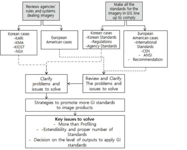
The work flow of this study is as follow. We reviewed rules of each representative agency dealing with images and also investigated the standards declared to be complied. Comparison of the rules and standards enabled us to clarify the gaps between the standards and the rules. When we notice the gap, we will prepare some strategies to find the way to make standards work in each agency to guarantee the interoperability (Fig. 1).
Fig. 1. Research Flow.
2. Reviews of agencies’ rules and systems dealing with imageries in foreign countries
1) EU’s Sentinel-2 case
One of the main features of Sentinel-2 mission was the high repetitiveness of the observations (5 days revisit). It emphasizes the potential of data time series and therefore drove the product definition: the basic Level-1 products had to be geometrically registered and radiometrically calibrated. The system product breakdown is as follows:
• the Level-0 and Level-1A are system products which correspond to respectively raw compressed and uncompressed data (limited to internal calibration purposes),
• The Level-1B is the first public product: it comprises radiometric corrections (dark signal, pixels response non uniformity, crosstalk, defective pixels, restoration, and binning for 60 m bands); and an enhanced physical geometric model appended to the product but not applied,
• The Level-1C provides ortho-rectified top of atmosphere reflectance with a sub-pixel multi-spectral and multi-date registration; a cloud and land/water mask is associated to the product. Note that the cloud mask also provides an indication about cirrus. The ground sampling distance of Level-1C product will be 10 m, 20 m or 60 m according to the band. The final Level-1C product is tiled following a pre-defined grid of 100 × 100 km
2, based on UTM/WGS84 reference frame; Upper level products (e.g. Level-2) are under definition.
Sentinel-2 products will also satisfy Quality Assurance for Earth Observation (QA4EO) recommendations made by CEOS (Baillarin, 2012). Radiometrically, spectral bands characteristics and the SNR (Signal to Noise Ration) for the reference radiances (Lref) were defined for each missions. It was accepted that a maximum 5% absolute calibration knowledge uncertainty was required for the mission, with an objective of 3%.
In a geometrical sense, image quality requirements correspond to two types of requirements: the first one is programming requirements to guarantee the satellite
pointing accuracy over the sites to be viewed, and the other is image quality requirements to be met by the Level-1 products using the ancillary data provided by the satellite and the data and models either calibrated in-flight or before the launch.
To achieve automatic registration process, Global Reference Image Database were built and simulated images were compared with processed images and any images with a refined geometric models can become a new reference. It allows updating the references according to the landscape seasonal evolutions. In case of EU Sentinel 2 satellite images, they focused on the traditional methods to evaluate the quality of image rather than applying general elements of Geographic Information data quality in International Standards.
2) NASA
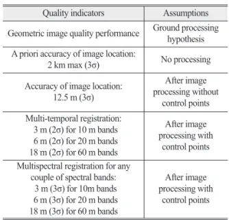
NASA defined requirements for imagery regardless airborne and satellite-borne. In contrast with EU, ISO 19115 metadata standard of geographic information was mentioned in NASA Earth Science Data Preservation Content Specification and in Digital Object Identifier (DOIs) for EOSDIS (Earth Science Data and Information System) and Data Management Plan Guidance were listed requirements. NASA also keeps the stakeholder
Table 1. Geometric image quality requirement Quality indicators Assumptions Geometric image quality performance Ground processing hypothesis
A priori accuracy of image location:
2 km max (3σ) No processing
Accuracy of image location:
12.5 m (3σ)
After image processing without
control points Multi-temporal registration:
3 m (2σ) for 10 m bands 6 m (2σ) for 20 m bands 18 m (2σ) for 60 m bands
After image processing with
control points Multispectral registration for any
couple of spectral bands:
3 m (3σ) for 10m bands 6 m (3σ) for 20 m bands 18 m (3σ) for 60 m bands
After image processing with
control points
to suggest action items including solutions and strategies as follows. The second line of Table 2 shows the importance of facilitating the access to understand data quality information of users. We are able to see that there are many levels in metadata. In a broad sense of metadata, metadata is the data on the data; however, metadata in standard is not as simple as broad and general context.
3. Reviews of agencies’ rules and systems dealing with imageries 1) Korea Aerospace Research Institute
Korea Aerospace Research Institute (KARI) is one of the main centers to archive satellite imagery and to provide satellite data from KOMPSAT, GeoKOMPSAT, COMS to the public as well as central and local governments. National satellite information and supporting center in KARI has played with application part of images to contact with client.
National Geographic Information Institute is in charge
of archiving aerial photography biannually. Some of local governments have archived imagery from drones and unmanned vehicles. National Satellite Information and Supporting Center provide monthly reports on positional accuracy, spectral accuracy and resolution of sensors on the web site. The unit of quality report is for all the images produced the previous month, which is assumed in average. The paper does not include quality elements designated in International Standard. As elements of data quality, methods, results, and detailed information are not provided, it is necessary for those who are concerned to look all the thumb nail images through with naked eyes.
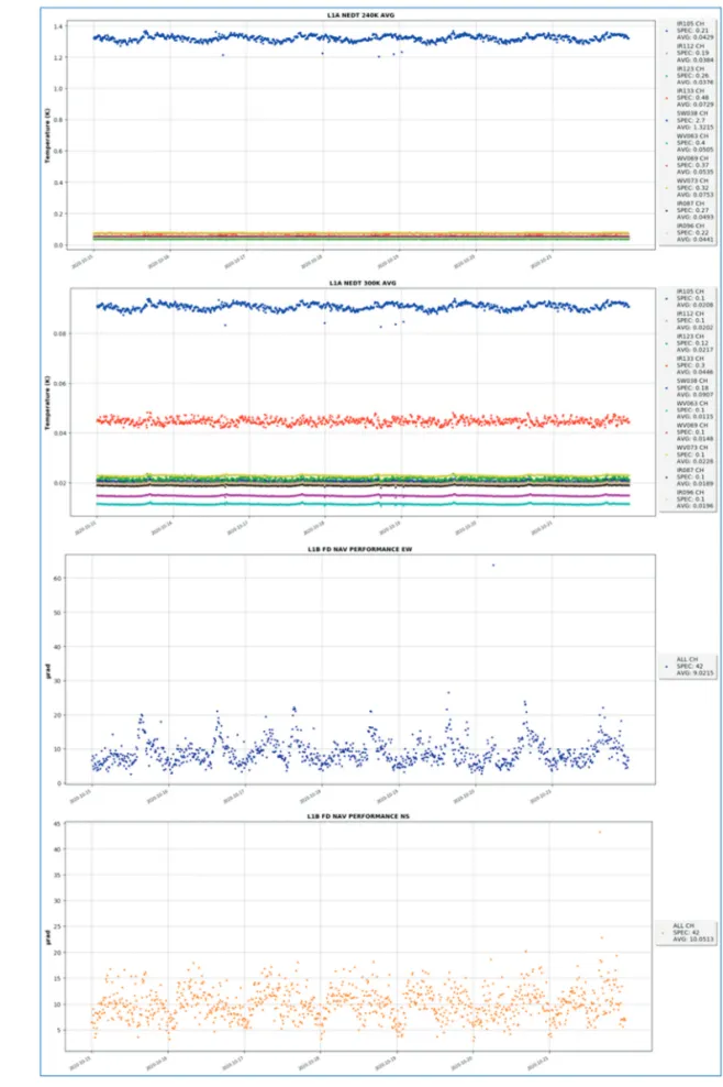
2) National Meteorological Satellite Center NMSC belonging to National Meteorological Agency creates positional and radiometric calibration and validation everyday (Fig. 2). The process of calibration of COMS data is based on GSICS (Global Space-based Inter-Calibration System) which was made by WMO and the CGMS (Coordination Group for Meteorological Table 2. ESDIS (Earth Science Data and Information System), DAAC (Data Active Archive Center)
PRIA Solution Implementation Strategies Actioners
NASA Recommended
Use of ISO Standard https://www.ncdc.noaa.gov/atrac/index.html support Metadata creation ESDIS Help users to access and
understand data quality information
http://daac.ornl.gov/
http://daymet.ornl.gov/ User support ESDIS/DAACs
Metadata authoring and
validating tools https://git.earthdata.nasa.gov/projects/DAACSUB/
repos/daac-ingestdashboard/browse Support Metadata Creation:
Support Metadata Validation ESDIS/DAACs Develop tools to help users
to leverage data quality
information https://daymet.ornl.gov/ User Support ESDIS/DAACs
Finer-levels of metadata https://podaac.jpl.nasa.gov/forum/ Consolidate Quality information Representation
Support Metadata Creation ESDIS
Science Advice http://science.nasa Guidance. Instruction,
and dissemination ESDIS Facilitate DAAC-PI
communication https://earthdata.nasa.gov/eosdis/daacs/ornl Facilitate DAAC- PI
Communication ESDIS
Data quality best practices https://atmosphere-imager.gsfc.nasa.gov/_docs/
QA_Plan_C6_Master_2015_05_05.pdf Guidance. Instruction,
and dissemination DAACs
Fig. 2. Quality Report of COMS data by NMSC.
Satellites). NMSC is one of the satellite operation bodies, which is in charge of managing the quality of satellite images. STEPI group have pointed out that satellite images needed to be serviced following international standards to enhance open data information Service. In the report, they reviewed TC211, OGC, WMO, TC146, respectively. All the standards in EU and Japan are also summarized but it was not clear to apply all the standards working in system integrations and service as well.
3) National Ocean Satellite Center
There is no information service on data verification processes and the result on the web site, even though they have considered the activities of quality management including GOCI data download site (http://kosc.kiost.
ac.kr/p10/kosc_p11.html).
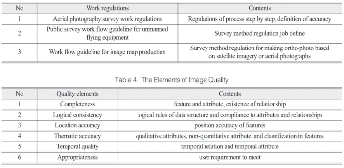
4) National Geographic Information Institute On the other hand, aerial photographs taken from airplanes and drones are propagated to the public by NGII (National Geographic Information Institute) and some local governments periodically. NGII have established the regulations on the minimum criteria for data quality like Table 3.
Table 3 shows three regulations dealing with all the processes with minimum requirement only for aerial photographs and UAV photos, not for satellite images.
All the quality reports showed in a Boolean way, pass or fail. Serviced images are supposed to have passed within the criteria. So we are able to say that NGII have quality management systems, but the information service does not look to be good enough or appropriate to satisfy the potential usages of clients. Since 2015, NGII has established its own institutional standard by profiling Korean Standards ㉿, which were compliant with International Standards TC 211. The standards on metadata, data specification, and data quality are the typical three standards which have been pushed to database builders in addition to the three regulations in the Table 3.
Standards do not hold all the information how to have been made, but what the final data products are.
Finally, we have reached some conclusions that each center or institute has done its own methods for quality control without serious considering standards in image and gridded data. The types of report differ in agency by agency. Profiling from KS X ISO 19157 has been done with consulting and discussions with experts in NGII and other experts. Both KS X ISO 19157 and
Table 3. NGII regulation on the image processing
No Work regulations Contents
1 Aerial photography survey work regulations Regulations of process step by step, definition of accuracy 2 Public survey work flow guideline for unmanned
flying equipment Survey method regulation job define
3 Work flow guideline for image map production Survey method regulation for making ortho-photo based on satellite imagery or aerial photographs
Table 4. The Elements of Image Quality
No Quality elements Contents
1 Completeness feature and attribute, existence of relationship
2 Logical consistency logical rules of data structure and compliance to attributes and relationships
3 Location accuracy position accuracy of features
4 Thematic accuracy qualitative attributes, non-quantitative attribute, and classification in features
5 Temporal quality temporal relation and temporal attribute
6 Appropriateness user requirement to meet
profiled standards of NGII define the elements to describe the quality of products.
Table 4 shows the elements to evaluate the quality of geospatial data but it does not specify the concrete case for each element. The general elements are described in the standards, so each agency has decided the methods to make an instance for each element.
Consequently, the criteria and values may differ among the institutes, even though they consider the same standards for images. Clients will be able to get the consistent and systematic results from different institute, as they consider the international standard, National standard, or institutional standard by proper profiling process. Many factors must make impacts on
the quality of images from the flight of acquisition to choice of ground control points, but standard of image quality is not directly intended to measure the errors on the processes of the production, but to measure the ones of the final product.
4. Standards on imagery 1) ISO/TC 211 standards on images and
gridded data and adoption status in Korea Over 25 years, ISO technical committee 211 WG 6 has created 10 standards on images and gridded data and continued to make standards and harmonize them
Table 5. ISO/TC211 standards and status of adoption as Korean Standard in Aug. 2020 (www.isotc211.org)
No Standard number Title KS Adoption (Yes, No)
1 19101-2 Geographic information – Reference model – Part 2: Imagery Yes systematically reviewed
in Oct 2019
2 19121 TR Geographic information – Imagery and gridded data Yes
systematically reviewed in Feb 2018 3 19123 Geographic information – Schema for coverage geometry
and functions
systematically reviewed Yes in Feb 2018 4 19130-1 Geographic information – imagery sensor models for
geopositioning : fundamentals No
standardized in Sept 2018 5 19130-2 Geographic information – imagery sensor models for
geopositioning : SAR, INSAR,LIDAR and SONAR No
standardized in Feb 2014 6 19139-2 Geographic information – Metadata – XML schema
implementation – Part2: Extensions for imagery and gridded data
systematically reviewed Yes in April 2018
7 19157 Geographic information – Data Quality Yes
standardized in April 2018 8 19115-2 Geographic information – Metadata – acquisition and processing No
standardized in 2019 9 19159-1 TS Geographic information – Calibration and validation of remote
sensing imagery sensors and data: part1: optical sensors
standardized in 2014 No systematically reviewed on 2019 10 19159-2 TS Geographic information – Calibration and validation
of remote sensing imagery sensors and data: Lidar No standardized in 2016 11 19159-3 TS Geographic information – Calibration and validation of remote
sensing imagery sensors and data: SAR and InSAR No standardized in 2018 12 19163-1 Geographic information – Content components and encoding rules for
imagery and gridded data: part1: content model No
standardized in2016
to remove inconsistency in data models. The Table 5 shows that twelve standards have been made on imagery and gridded data. Publication will be facilitated if authors check carefully the symbols, abbreviations, and technical terms for accuracy, consistency, and readability and ensure that manuscripts and illustrations meet the requirements outlined below.
2) OGC standards for imagery
Even though seven OGC standards on imagery have been published and reviewed systematically in Open Geospatial Consortium, no standards have been translated formally and standardized institutionally in Korea. But GeoTIFF, HDF5 and JPEG 2000 are very popular beyond satellite imagery; they have been regarded as De facto Standards. Software developers have used these standards to implement functions of images.
Some of these standards include data quality element;
however, a little in auxiliary text. See the Table 6.
5. Issues and Solutions
1) Image quality depending on calibration and validation
Satellites have limited years for missions, usually less than 10 years, but the data for monitoring climatic changes needs at least 30 years’ data. Even though the
sensor designs and specifications have been kept as consistent as possible, the indices and parameters may have been altered. To guarantee the consistency among the sensors on the satellite, calibration and validation processes are standardized even though new patterns have been tried to improve the image quality.
2) Reducing of the number of standards for expressing
If we insist on all the standards on satellite image from International Standard and OGC standards, software developers and users would not accept the rationale of compliance to the standards. Profiling standards is required for encouraging the standards to be kept during the processes of images. Some standards are very abstract and cover all the aspects to be expanded to all the cases, but each agency does have a specific condition and environment, optional and condition property in classes in data quality may differ case by case. Mandatory items should be included to define the quality of images.
3) Different criteria of high resolution data from low resolution data
When we deal with relatively low resolution image data such as Landsat TM and SPOT data, various algorithms were introduced to remove systematic errors such as removing strips which were made from sensor Table 6. OGC standards on imagery (https://www.ogc.org/docs/is)
No Documentation
number Title KS or other adoption
(Yes, No) 1 06-080r4 Catalogue Services Standard 2.0 Extension Package for ebRIM Application
Profile: Earth Observation Products (2010.02) No
2 08-085r8 OGC GML in JPEG 2000 (GMLJP2)
Encoding Standard Part 1: Core (2018.08) No
3 19-008r4 OGC GeoTIFF standard (2019.9) No
4 18-043r3 OGC Hierarchical Data Format Version 5 (HDF5®) Standard No
5 14-100r2 OGC network Common Data Form (netCDF) standards suite (2015.11) No
6 08-094r1 OGC® SWE Common Data Model Encoding Standard (2011.01) No
7 13-026r8 OpenSearch Extension for Earth Observation (2016.12) No
array malfunction, moderating high values made by overcharging anomaly. Most of image quality assessments for scientific research were determined in systematic ways but the algorithms had been applied on specific sample images. As spatial resolution of image is getting higher and higher, different phenomena were observed and discussed such as the angle of off nadir, shadow effects of high buildings in cities, rates of thick clouds per image.
6. Conclusions
It is hard to say a specific way is the best to apply international standard to define image quality taken on airplanes, satellites and unmanned autonomous vehicles. But it is possible to draw three meaningful conclusions based on the reviews of each agency’s case and regulations and standards.
First of all, ISO 19157 can be basically used for define the elements of data quality, methods and results.
But it is necessary to add more elements or classes to represent the characteristics of images instead of geographic features. Secondly, additional information should be considered based on the factors which may affect the quality of images, for example, duration of sensor missions, status of processing, calibration and validation elements.
Regulations and traditional methods to evaluate the sensor itself, or images are process-oriented, but product-oriented. However, the products are not independent of processes. To deliver appropriate result of image quality, some of the information on processing may be a part of elements in standards.
Thirdly, it is necessary to discuss the unit of the images. Strips or frames of image can be a one of the unit to define the quality, but the units can be defined differently in case of automation processes to make ortho-photo with DEM. Algorithms or GCP chips may make an effect on the results of the ortho-photo’s
quality. We did not mention the quality of derived images from specific algorithms to make thematic images or maps, but we discussed the quality of true color images in general. Public users may not need as much data quality information as in detail as experts in image processing. It is important to make image providers keep the information being compliant with national standards or Institutional standards are one of the important for satellite image users.
Acknowledgements
This research was supported by a grant (20SIUE- B148450-03) from CAS 500-1/2 Image Acquisition and Utilization Technology Development Program funded by Ministry of Land, Infrastructure and Transport of Korean government
References
Baillarin, S. J., A. Myegret, C. Dechoz, B. Petrucci, S.
Lacherade, T. Tremas, C. Isola, P. Martimort, and F. Spoto, 2012, Sentinel-2 Level 1 products and image processing performances, Int. Arch.
Photogramm, Remote Sens. Spatial Inf. Sci., 39-B1: 197-202.
Chang, E. M., Y. J. Park, S. A. Moon, 2019. The Midterm Report of CAS 500 1/2 Image Acquisition and Utilization Technology Development, Korea Agency for Infrastructure Technology Advancement, Anyang, Korea.
Coops, N. C. and T. R. Tooke, 2017, Introduction to Remote Sensing, In: Gergel S., Turner M. (Ed.), Learning Landscape Ecology, Springer, New York, USA, pp. 3-19.
DPDG Working Group, 2020. Data Product Development Guide for Data Producers, NASA ESDS, USA Im, J. H, H. S. Sagong, and Y. D. Kwon, 2001, Analyses
알파벳순 정렬하였음.