고해상도 위성영상을 이용한 농촌 도로 매핑을 위한 영상 분류 및 영상 분할 방법 비교에 관한 연구*
정윤재
1·구본엽
2※Comparative Research of Image Classification and Image Segmentation Methods for Mapping Rural
Roads Using a High-resolution Satellite Image*
Yun-Jae CHOUNG
1·Bon-Yup GU
2※1
요 약
농촌 도로는 농촌 지역의 개발과 관리를 위한 핵심 기반시설로서 원격탐사 자료를 활용한 농촌 도로 관리 기술은 농촌 교통 인프라 확대, 농촌 주민의 삶의 질 개선을 위해 매우 중요하다. 본 연 구에서는 농촌 지역을 촬영한 고해상도 위성영상을 활용하여 농촌 도로를 매핑하기 위해 영상 분 류 방법과 영상 분할 방법을 다음의 과정을 통하여 비교하였다. 영상 분류의 경우, 심층 신경망 기 반 딥러닝 기법을 주어진 고해상도 위성영상에 적용하여 고정밀 객체 분류 지도를 제작하였고 이 로부터 농촌 도로 객체를 추출함으로써 농촌 도로를 매핑하였다. 영상 분할의 경우, multiresolution segmentation 기법을 동일한 위성영상에 적용하여 세그먼트 영상을 제작하였고 농촌 도로에 위치한 다중 객체들을 선택하고 이들을 최종적으로 융합하여 농촌 도로를 매핑하였 다. 영상 분류 및 영상 분할 방법을 통해 매핑한 농촌 도로의 정확도 검증을 위해 100개의 검사 점을 사용하였고 다음과 같은 결론을 도출하였다. 영상 분류 방법에서는 객체 분류 지도 내 오분 류 에러로 인해 영상 내 일부 농촌 도로의 인식이 불가능하였으나 영상 분할 방법에서는 영상 내 모든 농촌 도로의 인식이 가능하였으므로 영상 분할 방법이 영상 분류 방법보다 위성영상을 이용 한 농촌 도로 매핑 작업에 더 적합한 방법이었다. 그러나 영상 분할 방법을 통해 매핑한 농촌 도 로를 구성하는 일부 세그먼트들이 농촌 도로 외 객체를 포함하고 있어 영상 내 일부 농촌 도로에 서 오분류 에러가 발생하였다. 추후 연구에서는 객체 기반 분류 또는 합성곱 신경망 등 다양한 정 밀 객체 인식 기법을 고해상도 위성영상에 적용하여 농촌 도로의 정확도를 개선할 계획이다.
2021년 09월 14일 접수 Received on September 14, 2021 / 2021년 09월 23일 수정 Revised on September 23, 2021 / 2021년 09월 23일 심사완료 Accepted on September 23, 2021
* 본 연구는 산업통상자원부 및 한국산업기술평가관리원에서 지원하는 산업기술혁신사업(20005705, 자율주행 AI 컴퓨팅 모듈 검증 및 차량실증기술 개발)의 일환으로 수행되었음
1 ㈜지오씨엔아이 공간정보기술연구소 연구소장 CTO, Geospatial Research Center, GEO C&I. Co., Ltd.
2 ㈜지오씨엔아이 공간정보기술연구소 전무이사 Executive Director, Geospatial Research Center, GEO C&I. Co., Ltd.
※ Corresponding Author E-mail : [email protected]
주요어 : 고해상도 위성영상, 영상 분류, 영상 분할, 딥러닝, 농촌 도로
ABSTRACT
Rural roads are the significant infrastructure for developing and managing the rural areas, hence the utilization of the remote sensing datasets for managing the rural roads is necessary for expanding the rural transportation infrastructure and improving the life quality of the rural residents. In this research, the two different methods such as image classification and image segmentation were compared for mapping the rural road based on the given high-resolution satellite image acquired in the rural areas. In the image classification method, the deep learning with the multiple neural networks was employed to the given high-resolution satellite image for generating the object classification map, then the rural roads were mapped by extracting the road objects from the generated object classification map. In the image segmentation method, the multiresolution segmentation was employed to the same satellite image for generating the segment image, then the rural roads were mapped by merging the road objects located on the rural roads on the satellite image. We used the 100 checkpoints for assessing the accuracy of the two rural roads mapped by the different methods and drew the following conclusions. The image segmentation method had the better performance than the image classification method for mapping the rural roads using the give satellite image, because some of the rural roads mapped by the image classification method were not identified due to the miclassification errors occurred in the object classification map, while all of the rural roads mapped by the image segmentation method were identified.
However some of the rural roads mapped by the image segmentation method also had the miclassfication errors due to some rural road segments including the non-rural road objects. In future research the object-oriented classification or the convolutional neural networks widely used for detecting the precise objects from the image sources would be used for improving the accuracy of the rural roads using the high-resolution satellite image.
KEYWORDS : High-resolution Satellite Image, Image Classification, Image Segmentation, Deep Learning, Rural Road
서 론
농촌 도로(rural roads)는 “농촌지역의 소규 모 지방도로나 주로 사람들이 도보 이동을 돕는 소로(paths)와 같이 자동차의 교통량이 적거나 거의 없는 도로”를 의미한다(Kim, 2012). 농촌 도로는 주로 국가 도로체계에서 최말단의 도로 로 인식되며 주로 마을과 마을의 연결 또는 다 른 도로 네트워크와의 연결을 통해 지역적인 영
향을 미치는 역할을 하므로 농촌 주민들에게 기 초 서비스 공급을 통해 농촌 경제 발전과 농촌 주민의 삶의 질 향상에 없어서는 안 될 중요한 시설물이다(Kim, 2012).
위성영상 등 원격탐사 자료는 현장에 방문하 지 않고 광범위 지역을 정기적으로 관찰할 수 있어 도로 등 주요 시설물을 관리하는데 효율적 으로 활용될 수 있다. 원격탐사 자료를 활용하 여 도로 및 주변 시설물 매핑 연구는 많은 국내 외 연구자들에 의해 수행되었다. Choung(2017)
과 Kim et al.(2019a)는 MMS(Mobile Mapping System) LiDAR 자료를 활용하여 도로 주변 시설물을 추출하였으며, Kim et al.(2019b)는 MMS 데이터를 활용하여 도로 평탄성과 편경사 분석을 연구하였다. Mokhtarzade et al.(2008), Hormese and Saravanan(2016), Dai et al.
(2020)은 고해상도 위성영상으로부터 도로 추 출을 위한 연구를 진행하였다.
농촌 도로는 교통량이 상대적으로 적고 농촌 도로를 관리하는 지자체의 재정 상태가 상대적 으로 열악하여 고속 도로, 일반 도로 등에 비해 관리에 취약하다(Kim, 2012). 위성영상 등 원 격탐사 자료를 활용하여 고속 및 일반 도로 매 핑 연구는 국내외 연구자들에 의해 진행되었으 나 농촌 도로와 같은 소규모 도로 매핑 연구는 상대적으로 진행되지 않았다. 본 연구에서는 영 상자료로부터 객체를 탐지하기 위해 폭넓게 활 용되는 영상 분류(image classification) 방법 과 영상 분할(image segmentation) 방법을 고 해상도 위성영상에 개별적으로 적용하여 농촌 도로를 매핑하였고, 정확도 검증을 통해 두 가 지 방법 중 고해상도 위성영상을 이용한 농촌 도로 매핑에 더 적합한 방법을 토론하였으며, 개별 방법의 장단점을 분석하여 매핑한 농촌 도
로의 정확도를 개선하기 위한 결론을 도출하였다.
연구 방법
1. 연구 대상 지역 및 범위
본 연구에서는 위성영상 내 농촌 도로의 유 무, 기상조건 등을 고려하여 포항시 학성리 1㎢
지역을 2017년 3월 6일에 촬영한 KOMPSAT -3A 위성영상을 사용하였으며, 주어진 위성영 상은 총 4개의 다중분광 밴드(Red, Green, Blue, Near Infra-red)로 구성되었고 UTM(Universal Transverse Mercator) 좌표계로 투영되었다.
2. 연구 방법
고해상도 위성영상 기반 농촌 도로 매핑 연구 의 진행 과정은 그림 2에서 확인할 수 있다.
영상 분류는 특정한 규칙을 기반으로 영상 내 의 픽셀을 비슷한 특성을 가진 그룹으로 분류하는 작업을 의미하며, 훈련 샘플(training samples)이 필요한 감독 분류(supervised classification)와 훈련 샘플이 필요 없는 무감독 분류(unsupervised classification)로 구분된다(Choung and Jo, 2017). 영상 분류 방법은 원격탐사 자료 기반 토지피복도 제작 및 정밀 객체 인식 등 다양한
FIGURE 1. KOMPSAT-3A Satellite Image (left) acquired in the area of Hakseong-ri, Pohang (shown on OpenStreet Map) on March 6, 2017
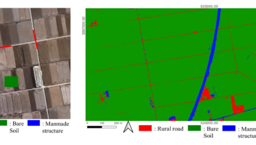
업무에 활용되고 있으며, 본 연구에서는 딥러닝 기술인 DNN(Deep Neural Network)을 주어 진 KOMPSAT-3A 위성영상에 적용하여 농어 촌 도로를 탐지하였다. DNN은 여러개의 은닉층 (hidden layer)을 가진 심층신경망으로 구성된 딥러닝(deep learning)의 핵심 모델로서 다중 분광 영상의 픽셀 밝기값의 비선형적인 관계를 학습할 수 있어 영상 내 객체 분류에 뛰어난 성 능을 보인다(Moon et al., 2020). DNN을 활용 한 객체 분류를 위해 농촌 도로 외에 주어진 위 성영상에서 확인할 수 있는 주요 객체인 나지 (bare soil)와 일반도로, 시설물 등을 포함한 인 공시설물(manmade structure)의 훈련 샘플을 QGIS 3.16을 활용하여 획득하였으며 충분한 양의 훈련 샘플 확보를 위해 개별 객체별로 500개 이상의 훈련 샘플을 픽셀 단위로 획득하 였다.
주어진 위성영상으로부터 농촌 도로, 나지,
인공시설물의 훈련 샘플을 취득하고 풍부한 인 공지능 라이브러리를 제공하는 Python 언어를 사용하였으며 위성영상에서 높은 정확도의 농촌 도로 객체를 인식하기 위해 반복적인 실험을 통 해 DNN 파라미터들을 지정하였다. DNN 모델 의 학습에 필요한 training data와 DNN 모델의 성능 평가에 필요한 test data의 비율은 7:3으 로 지정하였고, 입력 노드의 개수는 영상의 밴 드수와 동일하게 4개로 지정하였고, 은닉층의 개수와 각 은닉층의 노드 개수는 반복적인 실험 을 통해 각각 4개와 100개로 지정하였고, 출력 노드의 개수는 분류할 객체의 개수(농촌 도로, 나지, 인공시설물)와 동일하게 3개로 지정하였 다. 훈련 샘플을 기반으로 학습한 DNN 모델을 주어진 위성영상에 적용하여 제작한 객체 분류 지도는 그림 4에서 확인할 수 있다.
객체 분류 지도에서 농촌 도로 객체를 추출함 으로써 영상 분류 방법을 활용한 농촌 도로 매 FIGURE 2. Flowchart showing the procedure of comparing between
image classification and image segmentation methods for mapping the rural roads using the given KOMPSAT-3A satellite
image
핑 과정을 완료하였다(그림 5).
영상 분할은 영상 내 비슷한 특성(밝기, 질감, 평균, 표준편차 등)을 가진 주변의 픽셀들이 합 쳐져서 영상을 다중 객체 또는 의미 있는 객체 의 일부 영역인 세그먼트로 분할하는 과정을 의 미하며, 유사한 픽셀들을 모아 다수의 영역(세 그먼트)들로 구분하는 작업으로서 영상 내 배경
을 제거하고 효율적으로 객체를 탐지하는데 폭 넓게 활용되고 있다(Ahn and Oh, 2010). 본 연구에서는 영상 분할 업무에 폭넓게 활용되는 multiresolution segmentation 방법을 사용하여 주어진 KOMPSAT-3A 위성영상을 다중 세그먼트 들로 분할하였다. Multiresolution segmentation은 영상을 구성하는 다중분광 밴드의 가중치(image FIGURE 5. Rural roads mapped from the object classification map
FIGURE 3. Examples of the training samples selected from the given KOMPSAT-3A
satellite image
FIGURE 4. Object classification map generated from the given KOMPSAT-3A satellite image
using DNN
layer weights)와 세그먼트를 구성하는 픽셀값 의 변위(scale parameter), 세그먼트 모양과 색 상 사이의 가중치(shape), 세그먼트의 간결함 가 중치(compact)를 파라미터로 설정하여 영상을 다
수의 세그먼트로 분할하는 방법이다(eCognition, 2021). 본 연구에서는 반복적인 실험을 통해 multiresolution segmentation의 파라미터를 설정하였으며 표 1에서 확인할 수 있다.
FIGURE 7. Rural roads mapped by merging the multiple road segments generated from the given KOMPSAT-3A satellite image by using the multiresolution segmentation
(a) (b)
FIGURE 6. Segment image(a) generated from the given KOMPSAT-3A satellite image(b) by using the multiresolution segmentation
Parameters Values
Image layer weights 1(Red), 1(Green), 1(Blue), 2(NIR)
Scale parameter 50
Shape 0.9
Compact 0.9
TABLE 1. Parameters of multiresolution segmentation determined by repeated experiments
본 연구에서는 eCognition Developer 10.1을 사 용하여 표 1의 파라미터를 기반으로 multiresolution segmentation을 주어진 KOMPSAT-3A 위성 영상에 적용하여 세그먼트 영상을 제작하였으며 그림 6에서 확인할 수 있다.
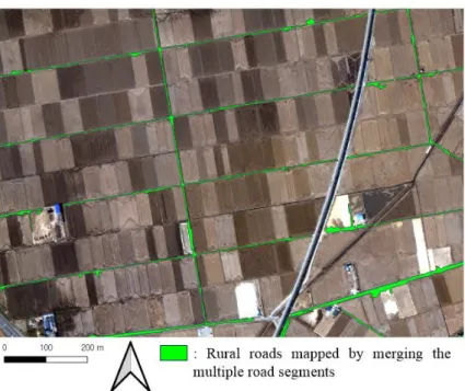
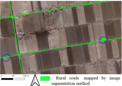
그림 6(a)의 세그먼트 영상에서 농촌 도로에 위치한 세그먼트(rural road segments)들을 수 동으로 선택하고 이들을 융합(merge)함으로써 농촌 도로를 매핑하였다(그림 7).
결과 및 고찰
본 연구에서는 영상 분류와 영상 분할 방법을 주어진 KOMPSAT-3A 위성영상에 적용하여
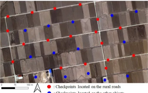
개별적으로 매핑한 농촌 도로의 정확도를 검증 하기 위하여 주어진 위성영상에서 농촌 도로 (60개)와 그 외 객체(나지 또는 인공시설물, 40개)에 일정한 간격으로 100개의 검사점 (checkpoint)를 제작하였다(그림 8).
본 연구에서는 두 가지 방법(영상 분류 및 영 상 분할)을 활용하여 개별적으로 매핑한 농촌 도로의 정확도를 검증하기 위해 오차행렬(error matrix)를 계산하였다(표 2~3).
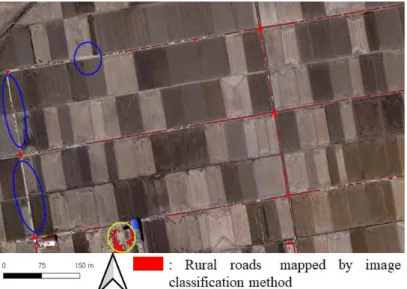
표 2~3에서 보는 바와 같이 영상 분류 방법 을 통해 매핑한 농촌 도로보다 영상 분할 방법 을 통해 매핑한 농촌 도로의 정확도가 높다는 사실을 확인할 수 있다. DNN을 주어진 위성영 상에 적용하여 제작한 객체 분류 지도(그림 4) 에서 농촌 도로의 일부 지역이 나지 또는 인공 시설물로 오분류되어 농촌 도로의 일부분이 추 출되지 않았으며(그림 9의 파란색 원) 일부 나 지 또는 인공시설물이 농촌 도로 객체로 오분류 되었다(그림 9의 노란색 원). 그러므로 영상 분 류 방법에서는 농촌 도로의 일부가 매핑되지 않 았으며 농촌 도로가 아닌 일부 객체들이 농촌 도로로 오분류되어 정밀한 농촌 도로 매핑 작업
FIGURE 8. Locations of 100 checkpoints located on the given KOMPSAT-3A satellite image with the regular intervals
에 한계가 있었다.
반면에 영상 분할 방법에서는 위성 영상 내 농촌 도로에 위치한 모든 세그먼트들을 융합 (merge)하여 농촌 도로 객체를 최종적으로 제 작하였으므로 영상 내 모든 농촌 도로가 매핑
되었으나 농촌 도로를 구성하는 일부 세그먼트 들이 농촌 도로 외 나지 또는 인공시설물 등 인 접 객체를 포함하고 있어 매핑한 농촌 도로 객 체의 일부가 오분류되었다(그림 10의 파란색 원).
Class Rural road(Reference) Others(Reference) Total User’s accuracy
Rural road
(Classification) 40 10 50 80%
Others
(Classification) 20 30 50 60%
Total 60 40 100
Producer’s accuracy 66.7% 75% 70%
TABLE 2. Accuracy of the rural road mapped from the given KOMPSAT-3A satellite image by using image classification
Class Rural road(Reference) Others(Reference) Total User’s accuracy
Rural road
(Classification) 60 3 63 95.2%
Others
(Classification) 0 37 37 100%
Total 60 40 100
Producer’s accuracy 100% 92.5% 97%
(Overall)
TABLE 3. Accuracy of the rural road mapped from the given KOMPSAT-3A satellite image by using image segmentation
FIGURE 9. Examples of the rural roads mapped by the image classification method
그림 9~10에서 보는 바와 같이 주어진 위성 영상을 이용하여 농촌 도로를 매핑하기 위해 영 상 분류 방법보다 영상 분할 방법이 더 적합하 였으나 영상 분할 방법을 이용하여 매핑한 농촌 도로에서도 농촌 도로가 아닌 객체를 포함하는 일부 세그먼트들로 인해 오분류가 발생하였으므 로 추후 연구에서 보완이 필요하다는 결론을 도 출하였다.
결 론
본 연구에서는 농촌 지역을 촬영한 고해상도 위성영상을 기반으로 농촌 도로를 매핑하기 위 해 두 가지 방법(영상 분류 및 영상 분할)을 개 별적으로 적용하였고 두 방법의 장단점을 분석 하였다. 영상 분류 방법의 경우 주어진 위성영 상으로부터 수작업을 통해 획득한 훈련 샘플을 기반으로 학습한 분류 모델을 통해 객체 인식 지도를 제작 후 농촌 도로 객체를 매핑하였다.
영상 분할 방법의 경우 동일한 위성영상에 다양 한 파라미터를 적용하여 세그먼트 영상을 제작 하였다. 또한, 농촌 도로에 위치한 세그먼트들을 선택하고 이를 융합하여 최종적으로 농촌 도로 객체를 매핑하였다. 두 가지 방법 모두 수작업
이 일부 포함된 반자동화 방법이었으나 영상 분 할 방법을 활용할 경우 고해상도 위성영상 내 위치한 농촌 도로의 전부를 100% 매핑할 수 있어 영상 분류 방법에 비해 더 적합함을 알 수 있었다. 그러나 영상 분할 방법을 통해 매핑한 농촌 도로의 일부 세그먼트들의 경우 농촌 도로 외 객체를 포함하는 오분류가 발생하는 한계가 있었다. 이에 추후 연구에서는 고해상도 영상으 로부터 정밀 객체를 분류하는데 폭넓게 활용되는 객체 기반 분류(object-oriented classification) 또는 U-Net 등 객체의 외곽을 구분할 수 있는 합성곱 신경망 기반 딥러닝 기술을 활용하여 농촌 도로 정밀 매핑 기술을 개발할 계획이다.
REFERENCES
Ahn. S.H. and J.S. Oh. 2010. Image segmentation algorithm for fish object extraction. The Journal of the Korea Institute of Maritime Information & Communication Science 14 (8):1819-1826 (안수홍, 오정수. 2010. 어 류객체 추출을 위한 영상분할 알고리즘. 한국 해양정보통신학회논문지 14(8): 1819-1826).
FIGURE 10. Examples of the rural roads mapped by the image segmentation method
Choung, Y.J. 2017. Extraction of 3D objects around roads using MMS LiDAR data.
Journal of the Korean Association of Geographic Information Studies 20(1):
152-161 (정윤재. 2017. MMS LiDAR 자 료를 이용한 도로 주변 3차원 객체 추출. 한 국지리정보학회지 20(1):152-161).
Choung, Y.J. and M.H. Jo. 2017. Comparison between a machine-learning-based method and a water-index-based method for shoreline mapping using a high-resolution satellite image acquired in Hwado Island, South Korea. Journal of Sensors 2017:1 -13.
Dai, J., T. Zhu, Y. Wang, R. Ma and X.
Fang. 2020. Road extraction from high -resolution satellite images based on multiple descriptors. IEEE Journal of Selected Topics in Applied Earth Observations and Remote Sensing 13:227-240.
eCognition. 2021. Basic rule set editing.
https://docs.ecognition.com/v9.5.0/eCognit ion_documentation/User%20Guide%20Dev eloper/4%20Basic%20Rule%20Set%20Edi ting.htm. (Accessed September 2, 2021).
Hormese, J. and C. Saravanan. 2016. Automated road extraction from high resolution satellite images. Procedia Technology 24:1460-1467.
Kim, G.C., H.S. Yoon and Y.S. Choi. 2019b.
Analysis of road surface irregularity and superelevation using mobile mapping system. Journal of the Korean Association of Geographic Information Studies 22(3):
155-166 (김기창, 윤하수, 최윤수. 2019b.
Mobile Mapping System을 이용한 도로 평 탄성과 편경사 분석 연구. 한국지리정보학회 지 22(3):155-166).
Kim, J.H., H.S. Lee, S.L. Roh and D.H. Lee.
2019a. Evaluating a positioning accuracy of roadside facilities DB constructed from mobile mapping system point cloud.
Journal of the Korean Association of Geographic Information Studies 22(3):99 -106 (김재학, 이홍술, 노수래, 이동하. 2019a.
Mobile Mapping System Point Cloud를 활 용한 도로주변 시설물 DB 구축 및 위치 정확 도 평가. 한국지리정보학회지 22(3):99-106).
Kim, K.S. 2012. A study on improvement of public transportation and road systems in rural areas. Korea Rural Economic Institute Research Report. 104pp (김광선.
2012. 농촌 대중교통 및 도로체계 개선 방안.
한국농촌경제연구원 연구 보고서. 104pp).
Mokhtarzade, M., M. J. Valadan Zoej and H.
Ebadi. 2008. Automatic road extraction from high resolution satellite images using neural networks, texture analysis, fuzzy clustering and genetic algorithms.
Proceedings of International Archieves of Photogrammetry, Remote Sensing and Spatial Information Sciences. pp.549- 559.
Moon, G.S., K.S. Kim and Y.J. Choung.
2020. Land cover classification based on high resolution KOMPSAT-3 satellite imagery using deep neural network.
Journal of the Korean Association of Geographic Information Studies 23(3):252-262 (문갑수, 김경섭, 정윤재.
2020. 심층신경망 모델을 이용한 고해상도 KOMPSAT-3 위성영상 기반 토지피복 분류.
한국지리정보학회지 23(3):252-262).