• 검색 결과가 없습니다.

Spatiotemporal Resolution Enhancement of PM<sub>10</sub> Concentration Data Using Satellite Image and Sensor Data in Deep Learning

N/A
N/A
Protected

Academic year: 2021

Share "Spatiotemporal Resolution Enhancement of PM<sub>10</sub> Concentration Data Using Satellite Image and Sensor Data in Deep Learning"

Copied!
7
0
0

로드 중.... (전체 텍스트 보기)

전체 글

(1)

위성 영상과 관측 센서 데이터를 이용한 PM10농도 데이터의 시공간 해상도 향상 딥러닝 모델 설계

Spatiotemporal Resolution Enhancement of PM10 Concentration Data Using Satellite Image and Sensor Data in Deep Learning

백창선1) · 염재홍2)

Baek, Chang-Sun · Yom, Jae-Hong

Abstract

  ×     

    

 × 



 ×

  ×



             

 

 ∼  log   

 ×    

∼   ∼   ∼  ∼ 



   

concentration is a spatiotemporal phenomenta and capturing data for such continuous phenomena is a

difficult task. This study designed a model that enhances spatiotemporal resolution of   ×     

    

 × 



 ×

  ×



             

 

 ∼  log   

 ×    

∼   ∼   ∼  ∼ 



    concentration levels

using satellite imagery, atmospheric and meteorological sensor data, and multiple deep learning models. The

designed deep learning model was trained using input data whose factors may affect concentration of   ×     

    

 × 



 ×

  ×



             

 

 ∼  log   

 ×    

∼   ∼   ∼  ∼ 



    , such

as meteorological conditions and land-use. Using this model,   ×     

    

 × 



 ×

  ×



             

 

 ∼  log   

 ×    

∼   ∼   ∼  ∼ 



    images having 15 minute temporal resolution and

  ×     

    

 × 



 ×

  ×



             

 

 ∼  log   

 ×    

∼   ∼   ∼  ∼ 



   

spatial resolution were produced with only atmospheric and meteorological data.

Keywords :   ×     

    

 × 



 ×

  ×



             

 

 ∼  log   

 ×    

∼   ∼   ∼  ∼ 



   

, Deep Learning, Satellite Image, Sensor Data, Spatiotemporal Resolution 초 록

  ×     

    

 × 



 ×

  ×



             

 

 ∼  log   

 ×    

∼   ∼   ∼  ∼ 



   

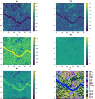
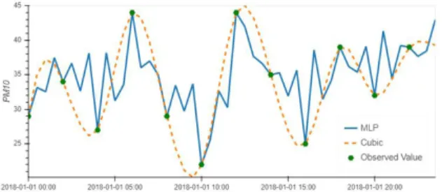
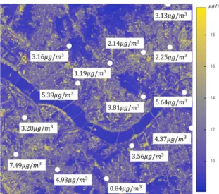
농도는 시간 및 공간 의존성을 동시에 가지는 시공간 데이터이지만 현실적으로 연속적인 시공간 데이터를

획득하는 것은 쉬운 일이 아니다. 본 연구에서는 위성영상과 대기질 및 기상 관측 센서 데이터를 복합적인 딥러닝

모델에 적용하여 시공간 해상도를 향상시키는 모델을 설계하였다. 설계된 딥러닝 모델은 기상, 토지 이용 등   ×     

    

 × 



 ×

  ×



             

 

 ∼  log   

 ×    

∼   ∼   ∼  ∼ 



   

농도에 영향을 줄 수 있는 인자를 이용하여 학습하였으며, 대기질 및 기상 관측 데이터만을 이용하여 15분 단위의

시간해상도와  ×     

    

 × 



 ×

  ×



             

 

 ∼  log   

 ×    

∼   ∼   ∼  ∼ 



   

공간해상도를 갖는   ×     

    

 × 



 ×

  ×



             

 

 ∼  log   

 ×    

∼   ∼   ∼  ∼ 



    영상을 생성하였다.

핵심어 :   ×     

    

 × 



 ×

  ×



             

 

 ∼  log   

 ×    

∼   ∼   ∼  ∼ 



    , 딥러닝, 위성 영상, 센서 데이터, 시공간 해상도

517 Received 2019. 11. 21, Revised 2019. 12. 07, Accepted 2019. 12. 26

1) Dept. of Geoinformation Engineering, Sejong University (E-mail: [email protected])

2) Corresponding Author, Member, Dept. of Environment, Energy & Geoinformatics, Sejong University (E-mail: [email protected]) Journal of the Korean Society of Surveying, Geodesy, Photogrammetry and Cartography

Vol. 37, No. 6, 517-523, 2019

https://doi.org/10.7848/ksgpc.2019.37.6.517

ISSN 1598-4850(Print) ISSN 2288-260X(Online) Original article

This is an Open Access article distributed under the terms of the Creative Commons Attribution Non-Commercial License (http://

creativecommons.org/licenses/by-nc/3.0) which permits unrestricted non-commercial use, distribution, and reproduction in any medium, provided the original work is properly cited.

수치

Fig. 1. Work flow
Fig. 2. Location of air quality and meteorological sensors in Seoul
Fig. 3. Example of input data: (a)       ×           
Fig. 6. LSTM architecture for prediction
+2

참조

관련 문서