Satellite data validation system using RC helicopter
Yoshiaki Honda, Koji Kajiwara CEReS, Chiba University 1-33 Yayoi, Inage, Chiba 263-8522, Japan
Tel/Fax 81-43-290-3835 E-mail [email protected]
Abstracts: This paper is introducing a radio control helicopter as a new platform of ground truth measurement. This helicopter is normally used for spraying an agricultural chemical. It can do pinpoint hovering and programing flight using DGPS etc., A spectrometer with dual port can measure ground surface and white reference plate at the same time.
And it can also take digital images by digital camera.
It is needed to collect ground reflectance information as satellite sensor footprint size for satellite data validation.
Generally it is possible to get such ground reflectance by an airplane measurement. But it is high cost and not so easy to make a measurement by airplane. Developed validation system can provide such ground reflectance in low cost and easy.
Keywords validation, BRDF, model
1. Introduction
Remote sensing data is useful to know a state of ground surface. However, some problems are still remaining in remote sensing data analysis. Bi-directional reflectance factor is one of such kind of problems. It is an effect of an angle, When the sun angle or sensor angle are changing, reflectance is also changing. This effect is related with 3 dimensional structure of ground surface.
Usually, Data is effected by bi-directional reflectance factor are not used for satellite data analysis, or converted to be a no effected data. However, if BRDF is clear and satellite data show BRF, satellite data will be available to know the information of 3 dimensional structure of ground surface.
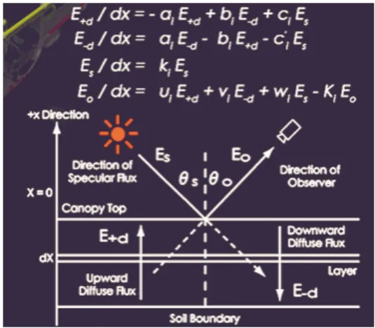
2. Layer model and actual reflectance
A lot of models have developed to make clear the effect of bi-directional reflectance factor. This is one of typical reflectance model s of vegetation canopy, called 4-flux theory of layer model (see fig.1).
Fig. 1 Layer model
In this model, a vegetation canopy is expressed by some layers that are horizontal and infinitely extended and homogenous. In this model, the leaf inclination densityȀ and the projection area of leaf and projection number of leaf are introduced as parameters. Those parameters are difficult to measure in ground truth observation. Then it is difficult to apply to a forest because of complex 3 dimensional structure, and to compare the reflectance model and the actual reflectance of vegetation canopy. It is need for a lot of reflectance data observed from various angles. These are conventional measurement instruments. They have a problem that measurement view areas are limited.Ȁ Especially, it is difficult to measure in forest using them.Ȁ A reflectance model and a measurement system available in forest are needed.
Objectives of this study are followings;
1) Development of a measurement system available in forest.
2) Ground truth observation using this system.
3) Establishment of a bi-directional reflectance model available in forest from ground truth data analysis.
3.Measurement System and Ground Truth Observation
This study introduced a radio control helicopter as a new platform of ground truth measurement. This is normally used for spraying
an agricultural chemical. Specially, in this study, it has a hovering system and programming flight system with DGPS, and a spectrometer with dual port,
That can measure ground surface and white reference plate at the same time. I t can also take digital images by digital camera (see fig. 2).
Fig.2 RC Helicopter system
This is a measurement flight pattern. It has 2 flight directions that are principal plane and cross-principal plane with the radius of 30 meters.
This system can measure one target automatically from 34 points within 15 minutes.
These are digital images from RC helicopter.
They are Broad leaf forest and grassland in Montana, Coniferous forest in British Colombia, Transition area from grassland to desert in Mandalgobi (see fig. 3). These are spectrum data of each area (see fig. 4).
Fig.3 Image from RC Helicopter
Fig.4 Spectrum data
These are relations between sensor angle and reflectance (see fig. 5). These graphs show that sensor angle is changing, and reflectance is also changing.
Fig.6 Relations between sensor angle and
reflectance
4.Data Analysis and Estimating Bi-directional Reflectance
A Reflectance of one area is related with a reflectance of each component, like a vegetation, soil and shadow. Cover ratios of each component are also important factor. Cover ratio is expressed that ratio in the view area watched from each sensor angle.
Cover ratios will be estimated from distribution map of each component, and 3 dimentsional structure of vegetation canopy and ground surface. Because the sun and sensor angle make a shadow and shade in the area.
And these infomation will be able to obtained from ground truth observation. A relation between reflectance and cover ratio using ground truth data, and also estimation of the bi-directional reflectance using these infomation and relation. There are digital images from radio control helicopter in coniferous forest of Oregon, and calculating cover ratio dividing into 3 categories, that are vegetation, soil and shadow.
These images show that a change of shadow and shade are very important factor.
These are results of calculation (see fig.7).
Fig.7 Vegetation ratio and reflectance
These results show that there is a high correlation between reflectance and cover ratio. Especially, reflectance of near infrared is related with vegetation cover ratio.
First, digital elevation map is marged with distribution map of each component. Shadow area is estimated based on the sun angle. Images watched from each sensor angle are simulated.
There are results of the simulation. Left images are simulated images watched from each sensor angle. Right images are results of calculation of cover ratio from left images. These graphs show comparison between ground truth data and estimation (see fig.8).
Fig.8 Estimation of BRF
And using this regression line, reflectances of each angle are estimated. These results show a good fitting. These are summaries of data analysis and estimating bi-directional reflectance.
5.Conclution
A measurement system using radio control helicopter has been developed. It observed in some forest and obtained ground truth data, and estimated bi-directional reflectance from results of ground truth data analysis.
In ground truth observation, a vegetation canopy is not often homogenous, and lighting condition is not constantly good. Then conventional instruments and models are not available under that condition.
However using the measurement system and estimation method of this study, it is possible to estimate the bi-directional reflectance under that condition with digital image and digital elevation map and reflectance of each component.