Journal of the Korean Society of Surveying, Geodesy, Photogrammetry and Cartography Vol. 33, No. 4, 297-304, 2015
http://dx.doi.org/10.7848/ksgpc.2015.33.4.297
객체 기반의 IR-MAD 기법을 활용한 고해상도 위성영상의 무감독 변화탐지
Unsupervised Change Detection for Very High-spatial Resolution Satellite Imagery by Using Object-based IR-MAD Algorithm
최재완1)
Choi, Jaewan
Abstract
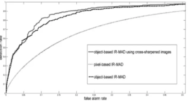
The change detection algorithms, based on remotely sensed satellite imagery, can be applied to various applications, such as the hazard/disaster analysis and the land monitoring. However, unchanged areas sometimes detected as the changed areas due to various errors in relief displacements and noise pixels, included in the original multi-temporal dataset at the application of unsupervised change detection algorithm. In this research, the object-based changed detection for the high-spatial resolution satellite images is applied by using the IR- MAD (Iteratively Reweighted- Multivariate Alteration Detection), which is one of those representative change detection algorithms. In additionally, we tried to increase the accuracy of change detection results with using the additional information, based on the cross-sharpening method. In the experiment, we used the KOMPSAT-2 satellite sensor, and resulted in the object-based IR-MAD algorithm, representing higher changed detection accuracy than that by the pixel-based IR-MAD. Also, the object-based IR-MAD, focused on cross-sharpened images, increased in accuracy of changed detection, compared to the original object-based IR-MAD. Through these experiments, we could conclude that the land monitoring and the change detection with the high-spatial- resolution satellite imagery can be accomplished efficiency by using the object-based IR-MAD algorithm.
Keywords : High-spatial Resolution Satellite Imagery, Object-based Change Detection, Cross-sharpened Images, IR-MAD
초 록
원격탐사 자료를 활용한 변화탐지 기법은 재난/재해, 국토모니터링 등의 다양한 분야에서 활용가능하다. 그러
나 , 고해상도 위성영상을 활용하여 무감독 변화탐지를 수행할 경우에는, 기복변위 등에 의한 기하학적인 오차와
영상의 노이즈 정보에 의하여 미변화지역들이 변화지역으로 오탐지될 수 있는 문제점을 지닌다. 따라서 본 연구에
서는 대표적인 변화탐지 기법인 IR-MAD 기법을 활용하여 고해상도 위성영상에 대한 객체 기반의 변화탐지를 수
행하였다 . 특히, 교차융합기법으로 부가적인 자료를 생성하여 객체 기반의 변화탐지 정확도를 향상시키고자 하였
다 . KOMPSAT-2 위성영상을 활용한 실험을 수행한 결과, 화소기반의 IR-MAD 기법과 비교하여 객체 기반의 IR- MAD 기법이 높은 변화탐지 정확도를 보이는 것을 확인하였다. 또한, 교차융합영상을 활용하였을 경우가 원 다시
기 영상만을 사용하였을 때보다 높은 변화탐지 정확도를 보였다. 이를 통해, 객체 기반의 IR-MAD 기법이 고해상
도 위성영상을 활용한 국토의 변화탐지를 효과적으로 수행할 수 있음을 실험적으로 증명하였다.
핵심어 : 고해상도 위성영상, 객체 기반의 변화탐지, 교차융합영상, IR-MAD
297 ISSN 1598-4850(Print) ISSN 2288-260X(Online) Original article
Received 2015. 07. 30, Revised 2015. 08. 05, Accepted 2015. 08. 22
1) Member, School of Civil Engineering, Chungbuk National University, Korea (E-mail: [email protected])
This is an Open Access article distributed under the terms of the Creative Commons Attribution Non-Commercial License (http://
creativecommons.org/licenses/by-nc/3.0) which permits unrestricted non-commercial use, distribution, and reproduction in any medium,
provided the original work is properly cited.
Journal of the Korean Society of Surveying, Geodesy, Photogrammetry and Cartography, Vol. 33, No. 4, 297-304, 2015
298
1. 서 론
KOMPSAT-2, 3 및 Worldview-3 등 1m 이내의 매우 높은 공간해상도(VHR, Very High-spatial Resolution)를 가지는 고해상도 위성영상 및 무인항공기(UAV, Unmanned Aerial Vehicle)에 의한 디지털 항공영상의 취득 가능성이 증대됨에 따라서, 고해상도 영상의 다양한 활용분야에 대한 연구가 증 대되고 있다. 특히, 도심지역을 포함한 국토의 변화양상의 모 니터링을 비롯하여, 재난/재해가 발생한 지역을 효과적으로 검출하기 위한 변화탐지 기법은 원격탐사 및 사진측량을 포함 한 영상처리 분야에서 핵심적인 활용기술이다. 일반적인 변화 탐지 기법은 감독 변화탐지와 무감독 변화탐지 기법으로 구 분할 수 있다. 감독 변화탐지 기법의 경우에는 대상지역의 변 화지역 유무와 더불어 변화양상을 확인할 수 있는 장점을 가 지고 있지만, 훈련자료(training data)가 필요하기 때문에 사용 자의 개입이 필요한 단점을 지닌다. 무감독 변화탐지 기법은 변화지역의 변화유무만을 파악할 수 있지만, 훈련자료를 필 요로 하지 않음에 따라 사용자의 개입이 불필요한 장점을 지 닌다. 따라서, 효과적인 재난/재해 등의 모니터링 등의 목적을 위하여 빠른 시간내에 변화지역을 추출하기 위해서는 무감독 변화탐지 기법이 많은 활용가능성을 가지고 있으며, 이에 따 른 다양한 연구들이 진행되고 있는 실정이다.
원격탐사 영상을 이용한 무감독 변화탐지에 대한 연구 는 다중분광(multispectral) 영상, 초분광(hyperspectral) 영 상 등을 활용하여 진행되고 있으며, 30m 급의 중해상도 위 성영상과 1m 이내의 VHR 위성영상에 이르는 다양한 공간 해상도를 지니는 위성영상에 대하여 수행되고 있다. 국내의 경우, Park et al.(2003)이 위성영상의 변화탐지를 위하여 변 수 추정에 의한 임계치 추출 기법에 대한 연구를 수행하였 으며, Kim and Kim(2008)은 누적 유사도 측정 기법을 활 용하여 다중분광 및 초분광 영상에 대한 무감독 변화탐지 를 수행하였다. 또한, Wang et al.(2013)은 고해상도 위성영 상의 융합에 사용되어지는 융합평가 지수를 활용하여 변화 탐지를 수행하고, 이에 따른 정확도를 평가하였다. 국외의 경 우, Carvalho Junior et al.(2011)은 유클리디안(euclidean) 거 리, 마할라노비스(Mahalanobis) 거리, SAM(Spectral Angle Mapper), SCM(Spectral Correlation Mapper) 등을 이용하여 CVA(Change Vector Analysis) 기법을 적용하고, 이에 따른 결과를 분석하였다. 또한, Erturk and Plaza(2015)는 분광혼 합분석(spectral mixture analysis)을 이용하여 초분광 영상의 변화탐지를 수행하였다. 특히, Nielsen(2007)에 의하여 제안 된 IR-MAD(Iteratively Reweighted-Multivariate Alteration
Detection)은 다중분광 및 초분광 영상에 모두 적용가능하며, 기존의 변화탐지 기법들과 비교하여 높은 변화탐지 정확도를 가지는 대표적인 알고리즘으로 알려져 있다. 또한, Marpu et
al.(2011)은 최적의 초기변화지역 영상을 생성하고 이를 IR-MAD 기법에 적용하여 변화탐지 정확도를 향상시키고자 하 였으며 , Aleksandrowicz et al.(2014)는 NDVI(Normalized Difference Vegetation Index), 텍스쳐(texture) 정보, MAD 자료 등을 활용하여 유럽연합(EU) 국의 토지피복의 변화를 추정하고자 하였다. 그러나, 기존의 연구들은 다른 시기에 취 득된 다시기(multi-temporal) 위성영상들이 동일한 기하구조 를 가지고 있다고 가정하고 실험을 진행하였거나, 개체에 대 한 기복변위의 영향이 적은 30m급의 중해상도 위성영상을 이 용하여 변화탐지를 수행하였다. 따라서, 건물 등과 같은 개체 의 기복이 크게 발생할 수 있는 고해상도 위성영상의 경우에 는 기복변위 및 영상간 기하학적 차이를 최소화할 수 있는 변 화탐지 기법이 필요하다. 이를 위하여, Wu et al.(2013)는 기 하보정오차를 최소화하기 위한 OSP(Orthogonal Subspace Projection) 기반의 변화척도를 제안하였으며, Marchesi et
al.(2010)은 기하보정 오차의 영향을 최소화하는 고해상도 위성영상의 변화탐지 기법을 개발하고자 하였다. 또한, Wang et
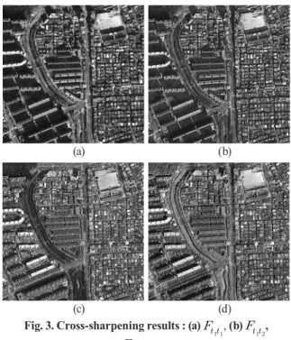
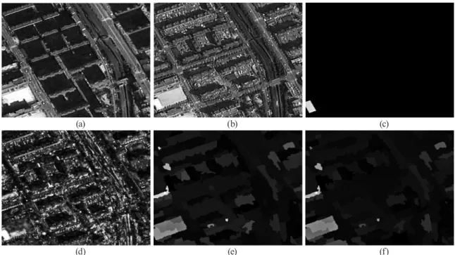
al.(2015a)는 영상융합 기법을 활용하여 기하보정 오차를 최소화할 수 있는 객체(object) 기반의 변화탐지 기법을 제안하 기도 하였다. 본 연구에서는 Wang et al.(2015a, 2015b)에서 제안한 가상의 융합영상 기법에 의하여 생성된 융합영상을 IR-MAD에 적용하였다. 특히, 일반적으로 중해상도 위성영 상에 적용했던 IR-MAD 기법을 객체 기반으로 확장하여, 고 해상도 위성영상에 적합한 객체 단위의 지형분석을 수행하고 자 하였으며, IR-MAD 기법을 객체 기반으로 적용하였을 경 우에의 성능을 분석하였다. 또한, 우리나라의 KOMPSAT-2 위성영상에 해당 기법을 적용할 경우에의 변화탐지 수행결 과를 분석하여, KOMPSAT-2 위성영상의 활용성을 검증하고 자 하였다.
2. 연구 방법