1 접수 2011년 10월 8일, 수정(1차: 2011년 12월 16일, 2차: 2012년 4월 4일), 게재확정 2012년 4월 5일 Received 8 October 2011; Revised(1st: 16 December 2011, 2nd: 4 April 2012); Accepted 5 April 2012 2 서울시청 푸른도시국 푸른도시정책과 Green Seoul Bureau, Seoul Metropolitan Government(100-191), Korea
3 서울시립대학교 도시과학대 조경학과 Dept. of Landscape Architecture, College of Urban Science, Univ. of Seoul, Seoulsiripdaero 163, Dongdaemun-gu, Seoul(130-743), Korea
4 도시생태학연구센터 Urban Ecology Research Center, 124-22 Bangi-dong, Songpa-gu, Seoul(138-052), Korea a 이 논문은 저자의 석사학위논문(조준수, 2009) 일부를 심사를 통해 발전시킨 것임.
* 교신저자 Corresponding author([email protected])
인왕산 소나무림의 경관변화와 문화경관림 복원방안 연구
1a조준수2․이경재3․한봉호3․기경석4*
A study on Restoration Plan of Cultural Forest and Change of Pinus densiflora Forest in Inwangsan(Mt.), Seoul1a
Jun-Soo Cho2, Kyong-Jae Lee3, Bong-Ho Han3, Kyong-Seok Ki4*
요 약
본 연구는 인왕산의 과거 기록자료 및 문화경관지역에 나타난 소나무림의 분포 특성을 파악하여 소나무림 경관 복원을 위한 관리방안을 수립하는데 목적이 있다. 인왕산의 과거 소나무림은 정선, 장시흥, 강희언의 산수화에서 잘 표현되어 있는데, 주로 동사면 능선부의 암반 주변을 표현하고 있었다. 인왕산 사진자료는 1800년대 말부터 기록되어 있는데 소나무림은 주로 서측 사면 저지대와 능선부에 분포하고 있었다. 인왕산의 문화유적 주변과 암반 주변 경관을 분석한 결과 대부분 소나무림이 우점하고 있었다. 인왕산의 과거 소나무림 경관을 형성하고 있는 지역을 대상으로 현존식생을 분석한 결과 소나무림을 유지하고 있는 지역은 51.87%, 인공림 변화한 지역이 25.80%이었다. 산림 저지대 소나무림은 대부분 시가화지역(10.16%)으로 변화되었다. 인왕산 소나무림 경관 복원을 위한 관리유형구분은 보전관리, 소나무복원관리, 유지관리로 설정하였다. 보전관리는 소나무림 분포지와 암반 분포지역으로 설정하였고 소나무 복원관 리는 능선부의 자생종 낙엽활엽수 분포지, 외래종 식생 분포지와 산림 내 훼손지역으로 설정하였다. 유지관리지역은 인왕산 저지대 시가화지역과 인왕산 정상부의 군부대 입지지역으로 설정하였다.
주요어: 기록자료, 진경산수화, 사진자료, 식생구조, 생태적 복원모델
ABSTRACT
The purpose of this study was to find characteristics of Pinus densiflora forests in previous records and cultural landscape regions and to establish a management method for recovery of P. densiflora landscape. A total of 16 landscape paintings were analyzed to study P. densiflora forests in Inwangsan(Mt.) shown in figure data. As a result of analyzing figure data, P. densiflora forests were found to be distributed mainly in the ridge line of east slope side of Inwangsan(Mt.) from landscape paintings of Jung Seon, Jang Si Heung and Gang Hee Un. In order to analyze the landscape of P. densiflora forests shown in photograph data on Inwangsan(Mt.), photographs of Inwangsan(Mt.) since late 1800s were searched and a total of 24 photographs were used for analysis. As a result of photographic analysis, P. densiflora forests were found to be distributed mainly in the
low area and ridge line of western slope side of Inwangsan(Mt.). As a result of analyzing the distribution status of 10 cultural heritages of Inwangsan(Mt.), cultural heritages in the mountain were mainly established with rocks and P. densiflora forests as the background and are establishing their landscape not only as a form of cultural heritage but also including the natural landscape in the background. A method of restoring cultural landscape of P. densiflora forests was necessary. As a result of analyzing 26 rock beds of Inwangsan(Mt.), most of P. densiflora forests were distributed nearby rock beds since the past. Among such regions, restoration and management of introduced species in the accumulated soil regions to P. densiflora forests were deemed necessary. As a result of analyzing current vegetation of P. densiflora forest areas of the past, 51.87% of areas maintained P. densiflora forest and 25.80% were changed to artificial forests. Most of low areas of the mountain were turned into urban area (10.16%). Management type for restoration of P. densiflora landscape of Inwangsan(Mt.) was classified into preservation, P. densiflora restoration and maintenance. Preservation management was configured as P. densiflora distribution and rocky area distribution. The targets of P.
densiflora restoration were indigenous broad-leaf trees, vegetation areas with introduced species and damaged regions within the mountain. The targets of maintenance were urban area in the low area of Inwangsan(Mt.) and military base at the top of the mountain.
KEY WORDS: RECORDED DATA, REAL LANDSCAPE PAINTING, PHOTOGRAPHY DATA, VEGETATION STRUCTURE, ECOLOGICAL RESTORATION MODEL
서 론
소나무는 우리 민족의 삶, 역사, 문화와 더불어 청렴, 인 내, 절개, 의지 등을 상징하며 전통사찰 및 문화재 등의 건축 재료 및 주요한 경관요소로서 문화경관을 형성해왔다. 우리 나라 소나무림은 조선시대 초기부터 벌채를 금하는 송목금 벌(松木禁伐) 정책에 따라 꾸준히 보전되어 왔을 정도로 (Jun, 2004) 역사문화적으로 중요한 문화경관림이다.
문화경관림은 아직까지 개념이 정립되거나 대상이 명확 하게 정해져 있지는 않다. 다만, 마을숲, 당산숲, 사찰림 등 과 같이 정주공간 주변에 위치하여 지역사람들에게 문화경 관적인 측면에서 효용을 제공하는 숲을 문화경관림이라고 정의할 수 있다. 따라서 본 연구에서는 ‘정주공간 주변에 위치하여 지역 사람들에게 문화경관 측면의 효용을 제공하 는 숲을 문화경관림이라고 정의’하고 연구를 진행하였다.
문화경관림에 대한 연구는 Lee et al.(1991)이 경상남도 함양군 함양음 대덕동의 신라말 진성여왕 때 조성된 대관림 중 상림(천연기념물 154호)을 대상으로 이용객에 의한 환경 피해 정도를 밝히고 식물군집구조를 밝혀 문화경관림의 관 리자료를 제공하였다. 또한 가야산국립공원 홍류동 계곡의 소나무림을 대상으로 식물군집구조를 규명하고 15년간의 식생구조 변화를 비교․분석하여 소나무림 보전관리를 위한 기초자료를 제공하였다(Lee et al., 2006). Lee et al.(2008) 는 오대산국립공원 월정사 전나무 숲의 식생구조 분석을
통해 문화․경관․관광자원 측면에서 관리방안을 제시하였으 며, Sim(2010)은 경기도 수원시 화성 내 팔달공원을 대상으 로 과거 자료 및 현장조사를 통해 세계문화유산에 적합한 식생경관복원을 위한 관리방안을 제시한 바 있다.
인왕산은 종로구 무악동, 사직동, 부암동 등과 서대문구 홍제동의 경계에 있는 서울 내사산의 하나로 도성의 우백호 (右白虎)에 해당된다. 인왕산은 필운산(弼雲山), 서봉(西 峰), 서산(西山)이라고도 하며, 광해군 때 인왕사(仁王寺) 라는 사찰이 있어 인왕산(仁王山)이라 부르게 되었다(Kim, 1994). 인왕산에 관한 연구는 1968년 1월 21일 북한 무장공 비의 청와대 습격사건을 계기로 안보상 인왕산의 방위체제 가 문제되어 25년간 출입이 통제됨에 따라 생태적 측면이나 인문학적 측면에서 연구가 거의 이루어지지 못했으나 1993 년 2월 25일 시민에게 개방되면서 현장조사를 통한 연구가 가능하게 되었다. 인왕산은 암반 및 소나무 식생경관이 수 려하여 조선시대 산수화에 주요 소재이었고, 산수화 속에 나타나 있는 식생은 주로 소나무군락이었다.
이상의 측면에서 인왕산의 과거자료를 분석하여 소나무 림의 분포위치를 파악하고 소나무림 복원을 위한 식생관리 방안을 도출하는 것은 의미 있는 일로 사료된다. 따라서 본 연구는 인왕산의 과거 기록자료 및 문화재, 암반 분포현황 분석과 현재 식생 현황과의 비교 분석을 통해 인왕산 소나 무 문화경관림 복원을 위한 관리방안을 수립하는데 그 목적 이 있다.
연구방법
1. 연구대상지
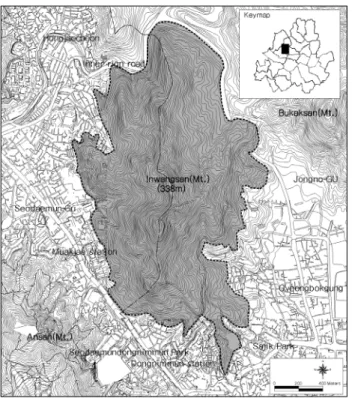
인왕산은 서울중심부(서울시청)에서 북서측 2.5km 지점 에 위치하고 있으며 주변에 북악산, 안산, 사직공원, 북한산 과 접하고 있다. 인왕산은 동측, 남측, 서측이 시가화지역으 로 둘러쌓여 있으며 북측은 자하문로와 세검정로에 의해 북안산과 단절되어 있다. 따라서 인왕산 연구대상지 경계는 시가화지역과 도로에 의해 단절되어 있는 산림에 한정하여 설정하였으며 면적은 2,552,497㎡이다. 인왕산은 암반돌출 형 산림으로 소나무에 의한 토지극상이 나타나는 지역이다.
Figure 1. The location of the survey site 2. 조사분석방법
인왕산 현존식생은 서울시 정밀 항공사진을 이용하여 암 반, 시설물, 식생분포지(침엽수, 활엽수 등) 등 식별이 가능한 시설물과 식생의 경계를 1/1,000 축척의 수치지도에 디지타 이징 한 후 현장에서 교목층 수종의 식생상관(vegetational physiognomy)을 기준으로 조사하여 식생경계를 도면화하 였다. 인왕산 전체 현존식생 조사는 2007년 10월에 실시하 였다.
인왕산 그림자료는 Choi(2006), Lee(1995), Jongno-Gu(1994),
PSS(2007), Park(2006)의 문헌을 고찰하여 조선 후기의 겸 재 정선(謙齋 鄭敾; 1676∼1759년)과 담졸(淡拙) 강희언 (姜熙彦; 1710∼1764년), 방호자(方壺子) 장시흥(張始興;
18세기)의 진경산수화를 분석하였다. 인왕산 그림자료의 식생은 그림에 표현되어 있는 암반, 건축물 등 지형지물과 수목의 형태를 판별하여 종을 확인하고 현존식생 조사결과 와 비교 분석하였다.
인왕산 사진자료는 서울역사 관련 문헌, 구한말, 일제시 대에 촬영된 사진자료, 신문기사의 사진 등 에 나타나 있는 다양한 사진자료를 분석하였다(PSS, 2007: Munhwailbo, 2008: Seoul Metropolitan City, 1984: Seoul Metropolitan Museum, 1998: SHCC, 2002; 2004: ISS, 1995: Lim, 1994:
Jongno-Gu, 1994: Choi, 1986; 2005). 인왕산 사진자료는 총 24장을 분석했으며 시대별로는 1800년대 말~1900년 이 전까지의 사진이 5장, 1900~1950년까지 9장, 1950~2000년 이전까지 10장으로 총 24장의 사진을 분석하였다. 이를 통 해 당시 인왕산의 소나무 생육지와 비생육지를 도면화하였 다.
인왕산 문화유적과 소나무림 경관을 파악하기 위해 인왕 산의 문화재와 암반 분포현황을 분석하였다. 인왕산의 문화 재는 사적, 중요 민속자료, 서울시 지정 유형문화재, 서울시 지정 유형 문화재, 서울시 지정 민속자료, 서울시 문화재 자료로 총 10개소를 분석하였다(Seoul Metropolitan City, 1984; SHCC, 2002; ISS, 1995; Jongno-Gu, 1994; Choi, 1986). 인왕산의 암반은 문헌고찰을 통해 형상이 독특하여 과거부터 명칭이 있는 바위의 위치 및 형태특성, 전설을 분 석하였다(Kim, 1994; Kim, 1990; SHCC, 1987; 2000).
과거 소나무림 생육지 분석은 그림자료와 사진자료에 나 타난 위치를 찾아 사진촬영을 실시하고 이를 과거 식생과 비교분석하였다. 사진촬영 시 사용한 카메라는 Canon EOS 5D이며, 렌즈구경은 근경사진 촬영시에는 Canon 24∼
70mm f2.8을 사용하였고, 원경사진 촬영시에는 Canon 70
∼200mm f2.8을 사용하였다.
인왕산 소나무림 복원방안은 그림자료, 사진자료, 문화유 적, 암반 분포자료를 종합적으로 분석하여 과거 소나무림 분포지를 도면화하고 과거 소나무림 분포지에 대한 현존식 생 유형을 분석하였다. 이를 통해 현존식생 유형별 소나무 림 보전, 복원, 유지지역을 설정하고 각 지역별 관리방향을 제시하였다.
결과 및 고찰
1. 현존식생
인왕산 현존식생은 소나무림(41.69%)이 가장 넓게 분포
Vegetation types Area(㎡) Ratio(%)
Native conifers Pinus densiflora community 1,064,176 41.69 41.69 Native deciduous Quercus acutissima community 175,828 6.89
Decidous broad-leaved community 22,731 0.89 7.78
Exotic conifers P. koraiensis community 4,864 0.19 0.19
Exotic deciduous Robinia pseudo-acacia community 828,074 32.44
32.87 Populus tomentiglandulosa community 11,041 0.43
Other forest
Shrub 1,631 0.06
2.17
Barren area 1,596 0.06
Rock beds 52,053 2.04
Planted area Planted area 43,359 1.70 1.70
Grass land Naturalized species 894 0.04 0.04
Arable area Dry fields 3,371 0.13 0.13
Urbanized area Small sports facilities 5,394 0.21
12.56
Urbanized area 315,282 12.35
Others Inaccessibel area(Military region) 22,205 0.87 0.87
Total 2,552,497 100.00 100.00
Table 1. The status of actual vegetation of Inwangsan (Mt.)(2007. 10)
Figure 2. The actual vegetation map of Inwangsan(Mt.) 하고 있으며 이외에 아까시나무림(32.44%), 상수리나무림 (6.89%)이 주로 분포하고 있다. 현존식생유형별 분포지역 을 살펴보면 소나무림은 산림 고지대 능선부와 사면 암반부 에 대면적으로 생육하고 있었다. 인공림인 아까시나무림과 은사시나무림은 소나무림, 상수리나무림과 비교하여 저지 대와 계곡부에 집중적으로 분포하였다. 소나무림 중 능선부
와 사면지역 아까시나무와의 접해 있는 소나무림은 팥배나 무, 상수리나무, 신갈나무 등의 교목성 낙엽활엽수와 경쟁 하고 있는 상태이었다.
2. 인왕산 기록자료에 나타난 소나무림 경관 특성
1) 인왕산 그림자료의 소나무림
인왕산 그림자료에 나타난 식생은 겸재 정선(謙齋 鄭敾) 의 인왕산 산수화나 18세기 후반 강희언(姜熙彦)의 인왕산 도(仁王山圖)에서 소나무림 경관이 강조되었다. 산수화에 표현된 당시의 그림들은 인왕산 북쪽과 동쪽기슭이 암반과 소나무림, 계곡부, 능선 등을 주로 표현하였으며 이를 통해 당시의 산림 능선부는 주로 소나무림이 생육하고 있음을 확인하였다.
과거 산수화의 배경이 되었던 지역들의 현재 식생 분포 현황은 해당지역의 현장 사진 촬영을 통해 분석하였다. 산 수화에 표현되어 있으면서 지금까지 소나무가 남아있는 지 역은 암반이 분포하고 토심이 얕은 소나무 토지극상 지역이 대부분이었다. 그러나 저지대 계곡부, 사면부와 같은 토양 퇴적지의 소나무림이었던 지역은 대부분 아까시나무, 은사 시나무 등의 외래종과 참나무류림이 분포하고 있다. 산림 주연부 지역은 과거 소나무림이 우점하고 있었으나 현재는 고밀 도시개발로 인하여 도로와 주거지가 분포하고 있다 (Table 2, Figure 3).
Painter Title Year Past distribution
P. densiflora forest Current distribution P. densiflora forest(2008. 12)
Jung, Seon (鄭敾)
Cheongpunggye(淸風溪) 1730,
1739 ▪ Rock beds, valley
▪ Ridge and rock beds: P. densiflora community
▪ Valley: R. pseudo-acacia community, Populus tomentiglandulosa community Samseungjomang(三勝眺望) 1740 ▪ Samseungjeong ridge, valley ▪ Upper ridge area: R. pseudo-acacia community
▪ Lower ridge area: P. densiflora community
Ingokjongsa(仁谷精舍) 1746 ▪ Okindong(Old P. densiflora community)
▪ Construction of road
▪ Upper roadside: Large P. densiflora community
▪ lower roadside: Q. acutissima community Punggyeyutaek(楓溪遺宅) 1746 ▪ North lowland of east slope ▪ Ridge: Large P. densiflora community
▪ Valley: Q. acutissima community Pilunsanghwa(弼雲賞花) 1750 ▪ Nusangdong valley ▪ All regions: R. pseudo-acacia community Yukganghyeon(六岡峴) 1750 ▪ East ridge and valley ▪ Roadside: R. pseudo-acacia community Suseongguji(壽城舊址) 1750 ▪ East ridge and valley ▪ Roadside: R. pseudo-acacia community Suseongdong(水聲洞) 1751 ▪ East ridge and valley, Rock
beds
▪ Slope: P. densiflora community
▪ Slope lowland: R. pseudo-acacia community
Inwangjaesaekdo(仁王霽色圖) 1751 ▪ Rock beds, valley, ridge
▪ Ridge: P. densiflora community
▪ Slope and lowland: R. pseudo-acacia community, Q. acutissima community Baekundong(白雲洞) 1755 ▪ Cheongundong valley and
ridge
▪ Ridge: P. densiflora community
▪ Other areas: R. pseudo-acacia community Changuimun(彰義門) 1755 ▪ Rock beds, valley, ridge ▪ Changes to urbanized areas
Jang, Si Heung (張始興)
Changuimun(彰義門) 18c ▪ Rock beds, valley, ridge ▪ Changes to urbanized areas
Pilundae(弼雲臺) End of
18c ▪ Rock beds, valley, ridge ▪ R. pseudo-acacia community Kang,
Hee Un
(姜熙焉) Inwangsando(仁王山圖) End of
18c ▪ Rock beds, valley, ridge
▪ Ridge: P. densiflora community
▪ Slope and lowland: R. pseudo-acacia community, Q. acutissima community Tabel 2. Past and Current Distribution of P. densiflora forest in the figure data, Inwangsan(Mt.)
Cheongpunggye (1730)
Cheongpunggye
(1739) Samseungjomang(1740) 2) 인왕산 사진자료의 소나무림
인왕산의 사진자료에 나타나 있는 식생은 1800년대 말 인왕산 능선부와 1890년 홍제원터가 주로 소나무림이었다.
1926년 사진자료와 1910년 사진자료에 나타난 소나무림은 인왕산 북동쪽 사면과 사직단 뒤편의 양호한 경관을 형성하 고 있었다. 그러나 1895년과 1897년의 독립문과 인왕산 경
Ingokjongsa(1746) Punggyeyutaek(1746) Pilunsanghwa(1750) Yukganghyeon(1750)
Suseongguji(1750) Suseongdong(1751) Inwangjaesaekdo(1751)
Baekundong(1755) Changuimun(1755) Changuimun(18c)
Pilundae(End of 18c) Inwangsando(End of 18c) Figure 3. Past figure data of Inwangsan(Mt.)
Current photograph(2008.12.3) of Cheongpunggye(1730)
Current photograph(2008.12.8) of Yukganghyeon(1750)
Current photograph(2008.12.3) of Suseongguji(1750)
Current photograph(2008.12.8) of Suseongdong(1751)
Current photograph(2008.12.3) of Inwangjaesaekdo(1751)
Current photograph(2008.12.3) of Baekundong(1755)
Current photograph(2008.12.3) of Changuimun(1755)
Current photograph(2008.12.3) of Changuimun(1755)
Current photograph(2008.12.3) of Pilundae(End of 18c) Figure 4. Current photograph of past figure data, Inwangsan(Mt.)
관을 촬영한 사진과 1900년대의 서대문 부근에서 촬영한 사진, 1903년 인왕산 서사면 무악재 인근의 경관 사진에서 는 인왕산 남사면과 서사면 북쪽에 식생이 거의 없는 나지 형태를 나타내고 있어 인왕산의 소나무림이 훼손된 것으로 판단되었다.
Table 3은 1800년대 말부터 1983년도까지의 인왕산 사 진자료에 나타난 소나무림 분포특성과 당시 촬영 지역의 2008년 현재 소나무 분포특성을 제시한 것이다. 100년 전 인왕산 식생경관은 1900년을 전후하여 촬영된 사진을 통해 서 그 모습이 확인할 수 있다. 무악동 일대 등 인왕산 남서쪽 은 수목이 없는 나지였으며 사직단 뒤편은 울창한 소나무림 이었다. 홍제원터가 있는 서쪽 기슭 지역은 계곡과 능선부 에 소나무가 생육하고 있었으며 동쪽 기슭 역시 어린 소나
무가 생육하고 있었다. 인왕산 동쪽 기슭은 조선시대에 경 복궁이나 각종 공공기관과 접해 있는 입지 조건에 의해 과 거의 모습을 많이 간직하고 있다. 인왕산 식생경관은 일제 시대에 급격하게 변화하였다. 이 시기에 인왕산 저지대 및 계곡부는 조선총독부와 인접해 있어 일본인을 포함한 인구 증가와 도시화의 압력으로 주거지가 확산되는 현상이 나타 났으며(An, 2006), 이로 인해 식생과 지형이 크게 훼손되었 다(Figure 6).
3. 인왕산 기록자료에 나타난 식생경관 변화 추정 인왕산 식생경관 변화는 그림자료와 사진자료를 토대로 시기별 변화를 추정하였다. 1800년대 말까지의 그림자료
Division Year Past distribution P. densiflora forest Current distribution P. densiflora forest(2008. 12)
End of 1800
~ 1900
In the late
1800s ▪Peaks and ridged: P. densiflora community ▪Rock beds and ridge around: P. densiflora community 1890 ▪South area: Absence of old P. densiflora community ▪Upper slope: P. densiflora community
1890 ▪Hongjewonteo around and western slope : P. densiflora community
▪Low Valley and slope: R. pseudo-acacia community
▪Upper slope: P. densiflora community dominated 1895 ▪Southwest slope(look at th Seodaemun)
: Absence of old P. densiflora community
▪Low slope: R. pseudo-acacia community
▪Upper slope: P. densiflora community 1897 ▪Southwest slope(Muakdong around)
: Absence of old P. densiflora community
▪Slope: R. pseudo-acacia community
▪Upper slope, Rock beds: P. densiflora community
1900
~ 1950
1900 ▪Southwest slope(look at th Seodaemun): Barren area ▪Peaks around: R. pseudo-acacia community 1900 ▪South slope(look at th Seodaemun)
: P. densiflora community and barren area ▪Changes of urbanized area 1900 ▪Euijuro around(Muakjae): Absence of P. densiflora
community
▪Low slope: R. pseudo-acacia community
▪Upper slope: P. densiflora community
1900 ▪East slope: Absence of P. densiflora community
▪Ridge: P. densiflora community
▪Slope and low area: R. pseudo-acacia community, Q. acutissima community
1903 ▪Southwest slope: Absence of P. densiflora community
▪Ridge: P. densiflora community
▪Slope and low area: R. pseudo-acacia community, Q. acutissima community 1910 ▪South slope(Sajikdan back): P. densiflora community ▪Sajikdan back: Dispearing of old P. densiflora
community
1924 ▪East slope(look at th Namsan): P. densiflora community
▪Ridge: P. densiflora community
▪Slope and low area: R. pseudo-acacia community, Q. acutissima community
1926 ▪Northeast slope: P. densiflora community
▪Upper slope: P. densiflora community
▪Residential around: R. pseudo-acacia community, Q. acutissima community
1950
~ 2000
1951 ▪East slope(Palace surroundings) : P. densiflora community
▪Ridge: P. densiflora community
▪Lower slope: R. pseudo-acacia community, Q. acutissima community 1955 ▪East slope(Inwangsan(Mt.) and Seoul landscape): P.
densiflora community
▪Ridge: P. densiflora community
▪Slope and low area: R. pseudo-acacia community, Q. acutissima community
1958 ▪Northreast slope(Jahamun around) : P. densiflora community
▪Ridge: P. densiflora community
▪Slope and low area: R. pseudo-acacia community, Q. acutissima community 1959 ▪Southwest slope(Look at the Docripmun)
: No old P. densiflora
▪Ridge: R. pseudo-acacia community
▪Upper ridge, peaks: P. densiflora community
1966 ▪East slope: P. densiflora community
▪Ridge: P. densiflora community
▪Slope and low area: R. pseudo-acacia community, Q. acutissima community 1969 ▪East slope(Nusangdong, Sajikdong around)
: P. densiflora community
▪Ridge: P. densiflora community
▪Slope and low area: R. pseudo-acacia community, Q. acutissima community
1970 ▪East slope(Look at the Daehanmun) : P. densiflora community
▪Ridge: P. densiflora community
▪Slope and low area: R. pseudo-acacia community, Q. acutissima community 1970 ▪Southwest slope(Look at the Docripmun)
: P. densiflora community
▪Slope: R. pseudo-acacia community
▪Upper slope: P. densiflora community
1973 East slope(Look at the korea bank) : P. densiflora community
▪Ridge: P. densiflora community
▪Slope and low area: R. pseudo-acacia community, Q. acutissima community
1983 ▪Southwest slope(Look at the Cheonyeondong): P.
densiflora community
▪Ridge: P. densiflora community
▪Slope and low area: R. pseudo-acacia community, Q. acutissima community
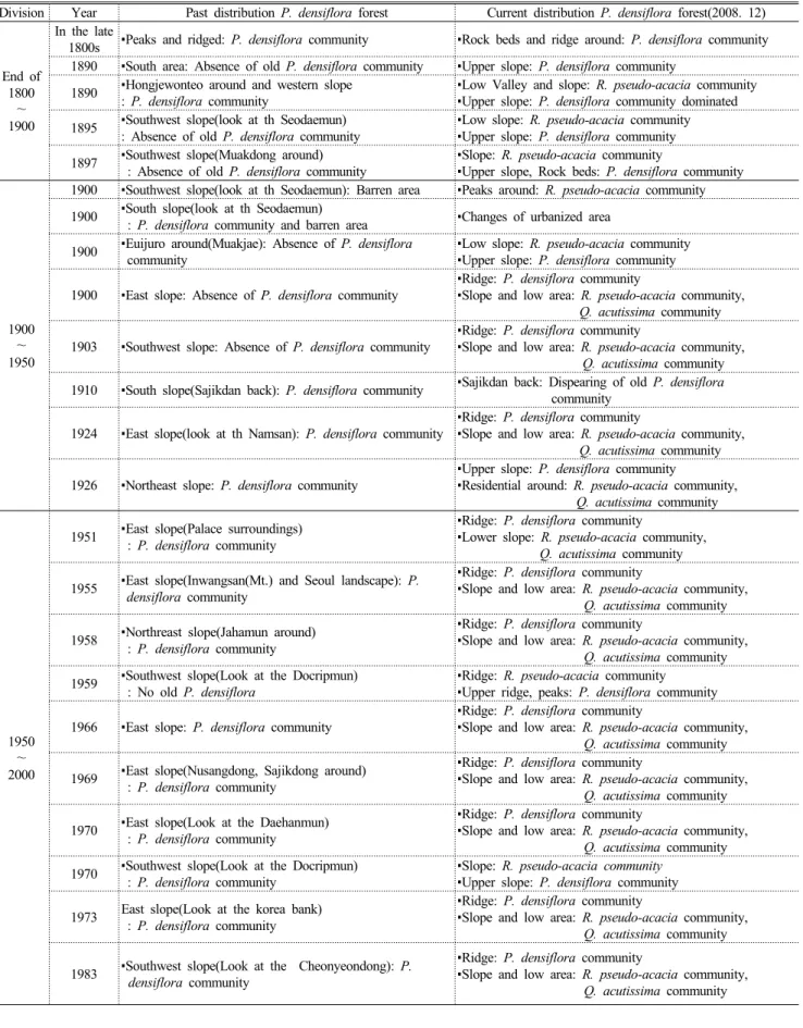
Table 3. Past and current distribution of P. densiflora forest in the photograph data, Inwangsan(Mt.)
In the late 1800s 1890 1890 1895
1897 1900 1900 1900
1900 1900 1903 1910
1924(Black line) 1926 1951 1955
Figure 5. Distribution of P. densiflora forest in the photograph data, Inwangsan(Mt.)
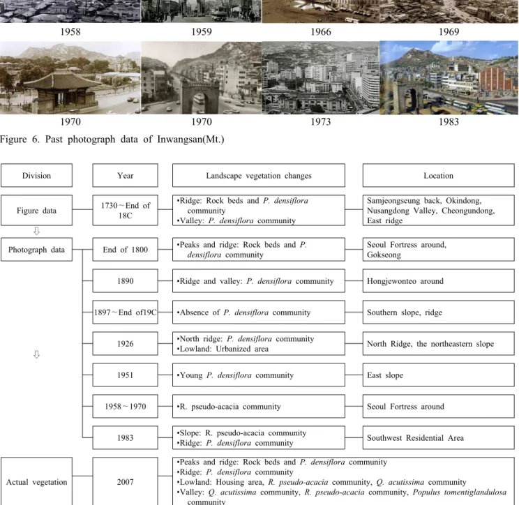
속의 인왕산은 암반과 능선부의 소나무림 경관 등의 자연경 관이 주요 소재가 되었다. 1897년에서 19c말 의주로에서 촬영한 인왕산 남측 사면 및 봉우리 사진은 소나무림이 훼 손되어 불량한 경관을 형성하고 있었다. 1926년 인왕산 북 측 능선 및 북동사면 사진에는 북쪽 기슭에 소나무림 경관을 형성하고 있고 저지대는 전체적으로 주거지 개발이 진행된 상태이었다. 1951년 인왕산 동사면 사진 분석결과 유령의 소나무림이 생육하고 있는 것으로 판단되었다. 1958~1970 년 서울 성곽 주변 사진은 인공림 식생경관이 주로 나타나 고 있었다.
인왕산의 현재 식생경관(2008년)은 봉우리, 능선부는 토 지극상에 의한 소나무림과 돌출된 암반이 경관을 형성하고 있고 산록부 일부 지역에 소나무림이 남아있는 상태이다.
이외에 산림 저지대는 주거지가 대면적으로 개발되었고 토 양 퇴적지는 대부분 아까시나무림과 상수리나무림이 우점 하고 있다. 계곡부는 주로 상수리나무림, 아까시나무림, 은 사시나무림이 분포하고 있다. 과거 기록자료를 바탕으로 할 때 인왕산의 원래 자연문화경관은 암반과 소나무림이 어우 러진 경관이었으나 일제시대 이후 식생훼손과 인공림 식재,
1958 1959 1966 1969
1970 1970 1973 1983
Figure 6. Past photograph data of Inwangsan(Mt.)
Division Year Landscape vegetation changes Location
Figure data 1730~End of 18C
▪Ridge: Rock beds and P. densiflora community
▪Valley: P. densiflora community
Samjeongseung back, Okindong, Nusangdong Valley, Cheongundong, East ridge
⇩
Photograph data End of 1800 ▪Peaks and ridge: Rock beds and P.
densiflora community
Seoul Fortress around, Gokseong
⇩
1890 ▪Ridge and valley: P. densiflora community Hongjewonteo around
1897~End of19C ▪Absence of P. densiflora community Southern slope, ridge
1926 ▪North ridge: P. densiflora community
▪Lowland: Urbanized area North Ridge, the northeastern slope
1951 ▪Young P. densiflora community East slope
1958~1970 ▪R. pseudo-acacia community Seoul Fortress around
1983 ▪Slope: R. pseudo-acacia community
▪Ridge: P. densiflora community Southwest Residential Area
Actual vegetation 2007
▪Peaks and ridge: Rock beds and P. densiflora community
▪Ridge: P. densiflora community
▪Lowland: Housing area, R. pseudo-acacia community, Q. acutissima community
▪Valley: Q. acutissima community, R. pseudo-acacia community, Populus tomentiglandulosa community
Figure 7. Estimating of vegetation landscape changes in recording data, Inwangsan(Mt.)
시가지 난개발로 인해 소나무림 경관을 포함한 자연경관 훼손되었다. 따라서 인왕산의 자연문화경관을 복원하기 위 해서는 과거 기록자료에 나타난 소나무림 분포지역을 중심 으로 소나무림의 복원이 필요한 것으로 판단된다.
4. 문화유적분포 및 암반 주변 식생경관 특성 인왕산 문화유적과 암반 주변의 소나무림 경관을 분석하 였다. 인왕산 내 문화유적은 사적은 서울 성곽 1개소이고
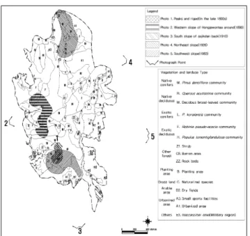
Actual vegetation type Area(㎡) Ratio(%) Natural Forest
P. densiflora community 554,142 51.87
57.57
Q. acutissima community 41,214 3.86
Decidous broad-leaved community 19,658 1.84 Artificial Forest R. pseudo-acacia community 273,713 25.62
25.80
P. koraiensis community 1,898 0.18
Rock beds Rock beds 32,706 3.06 3.06
Other green and openspace
Dry fields 1,424 0.13
1.37
Small sports facilities 2,987 0.28
Planting area 10,186 0.95
Urbanized area Inaccessible area(Military region) 21,876 2.05
12.21
Urbanized area 108,542 10.16
Total 1,068,347 100.00 100.00
Table 7. Area and ratio of Actual vegetation type of Past P. densiflora forest shown recorded data, Inwangsan(Mt.) Figure 8. Cultural heritage distribution of Inwangsan(Mt.) Figure 9. Rocks distribution of Inwangsan(Mt.) 중요 민속자료는 국사당이다. 서울시 지정 유형 문화재는
무계정사, 대원군 별장, 황학정, 석파정, 홍지문 5개소이고 서울시 지정 민속자료는 선바위, 윤웅렬가 2개소가 있다.
서울시 문화재자료는 필운대 1개소이다.
인왕산은 정상(338m)의 ‘삿갓바위’를 중심으로 남릉과 북릉, 동면과 서면 등으로 나뉘어진다. 인왕산의 암반 주변 식생을 살펴보면 삿갓바위 주변으로 서측경사면에 아까시 나무가 군락을 이루고 있으나 대부분 고사되었으며, 아교목 층으로 팥배나무, 아까시나무, 가죽나무가 생육하고 있다.
관목층으로 싸리류, 진달래, 국수나무 등이 생육하고 있다.
동측 경사면에는 팥배나무가 군락을 이루는 가운데 아까시 나무가 우점하고 있다. 치마바위, 기차바위, 장승바위 같이 넓고 큰 바위 사면과 절벽 주변으로는 소나무가 군락을 이 루거나 바위틈새에 단목으로 생육하고 있다. 부처님바위,
모자바위, 돼지바위, 두꺼비바위, 코끼리바위, 범바위 등은 인왕산 경사면 등에 산재 분포되어 있으나 바위 주변으로는 소나무가 군락을 이루고 있는 가운데 관목층으로 진달래와 싸리류가 함께 생육하고 있다. 말안장바위, 달팽이바위, 쉼 바위, 펭귄바위, 해골바위, 책바위, 매바위 등의 주변에는 진달래와 싸리류, 팥배나무, 아까시나무, 참나무류 등이 생 육하고 있으며 인근에는 소나무 군락이 넓게 분포하거나 암반과 함께 부분적으로 생육하고 있다.
5. 인왕산 소나무림 복원방안
1) 소나무림 복원대상지 설정
인왕산 소나무림 복원대상지는 그림자료, 사진자료, 문화 유적, 암반 분포자료를 중첩하여 도면화한 후 선정하였다.
Figure 10. Distribution of P. densiflora forest in the recording data, Inwangsan(Mt.)
Figure 11. Actual vegetation map of Past P. densiflora forest shown recorded data, Inwangsan(Mt.)
Management Types Management sites Area(㎡) Ratio(%)
Conservation P. densiflora Forest ▪ P. densiflora soil climax on the rock beds
▪ Slope and lowland P. densiflora community 554,142 51.87
54.93
Rock bed ▪ Rock beds of ridge 32,706 3.06
P. densiflora Restoration
Native deciduous broadleaf
▪ Mixed forest of Quercus community
▪ Other Native deciduous broadleaf commnity 60,872 5.70
32.90 Exotic vegetation ▪ Exotic conifers vegetation
▪ Exotic deciduous broadleaf vegetation 275,611 25.80 Destroyed forest
▪ Arable land in forest
▪ Small sports facilities
▪ Planting area
14,597 1.37
Maintenance Urbanized area ▪ Lowland urbanized area
▪ Military region 130,418 12.21 12.21
Total 1,068,347 100.00 100.00
Table 8. Ecological management plan for P. densiflora forest restoration, Inwangsan(Mt.) 산수화를 살펴보면 능선부의 암반을 제외한 지역은 주로
소나무림이 분포하고 있었다. 인왕산을 소재로 하거나 배경 으로 하고 있는 근현대 사진자료에서는 주로 인왕산의 서측 사면 저지대와 능선부에서 소나무림이 분포하고 있었다. 인 왕산 내 문화유적과 암반 주변은 현재 인공림이 주로 분포 하고 있는데 이는 대상지의 문화경관으로 부적합하며 소나 무림으로의 식생경관 복원이 적정한 것으로 판단되었다. 따 라서 문화재 분포지역과 암반 분포지역 인근의 인공림에 대해서는 소나무림 식생복원 지역으로 설정하였다.
기록자료, 문화유적, 암반 주변 지역의 소나무림 복원은 현존식생 유형 분석을 통해 생태적 관리방향을 도출하였다.
소나무림 복원대상지는 현재 자연림이 60.49%이고, 이 중 소나무림을 유지하고 있는 지역은 전체의 절반 이상
(55.24%)을 차지하고 있다. 식생이 분포하지 않는 암반은 3.06%로 분포하고 있다. 과거 소나무림에서 인공림으로 변 화한 지역은 아까시나무림(24.07%)과 잣나무림(0.19%)이 다. 산림 내 훼손지역은 밭, 소규모체육시설, 조경수목식재 지가 일부 분포하고 있다. 인왕산의 산림 저지대는 대부분 시가화지역으로 변하였으며 인왕산 능선부에는 군사지역 이 일부 분포하고 있다.
2) 소나무림 복원지역의 생태적 관리방안
인왕산 소나무림 경관 복원을 위한 관리유형구분은 크게 보전관리, 소나무복원관리, 유지관리로 구분하였다. 보전관 리는 소나무림 분포지역으로 토지극상의 소나무림 지역과 기존 소나무 순림 분포지역이 해당하였다. 암반 분포지역은
Figure 12. Ecological management plan for P. densiflora forest restoration, Inwangsan(Mt.)
인왕산 능선부의 암반이 노출된 지역이다.
소나무 복원 관리 대상지는 과거 소나무림이 분포하던 지역으로 소나무림 복원이 필요한 지역이다. 소나무림 복원 지역 중 자생종 낙엽활엽수 분포지역은 자생종 참나무류와 기타 낙엽활엽수 분포지역이다. 외래종 식생이 분포하는 지 역은 잣나무, 리기다소나무 등 외래종 침엽수와 아까시나 무, 은사시나무 등 외래종 활엽수가 분포하는 지역이다. 산 림 내 훼손지역은 산림 내 경작지, 체육시설, 조경수목식재 지이다. 유지관리지역은 과거 소나무림이었으나 현재 도시 화가 진행되어 소나무림으로 복원이 어려운 지역으로 인왕 산 저지대 시가화지역과 인왕산 정상부의 군부대 입지지역 이 이에 해당한다. Table 8은 인왕산 소나무림 경관 복원을 위한 생태적 관리유형별 면적 및 비율을 나타낸 것으로 보 전관리지역이 전체면적의 54.93%이며 소나무림 복원관리 는 32.90%, 시가화지역으로 복원이 어려운 유지관리지역 은 12.21%이다.
인용문헌
An, S.J.(2006) Landscapes and the powers of the eastern slope in Inwangsan : focusing on the analysis of land register. Korea National University of Education graduate school dissertation for the degree of master, Korea, 111pp. (in Korean with English abstract)
Bak, J.A.(2006) The Beautiful Past of Seoul. Borim Publishers Co., Ltd., 80pp. (in Korean)
Cho, J.S.(2009) A Study on Restoration Plan of Cultural Landscape Forest and Change of Pinus densiflora Forest in Inwangsan, Seoul. Graduate School of Urban Science University of Seoul, Thesis for the degree of master, 158pp. (in Korean with English abstract)
Choi, S.R.(1986) Photos of Modern Korea (first)-Mountain, River and Scenery-. Seomundang, 228pp. (in Korean)
Choi, S.R.(2005) Photos of the Joseon Dynasty People See Pictures
① - The Heart of the Nation․600 years of Seoul scenery -.
Seomundang, 214pp. (in Korean)
Choi, W.S.(2006) Gyemjae's Hanyang Real Scenary - Look at the Cheonggyecheon Ohgansumun after climbing to Bukak -.
Dongailbo, 355pp. (in Korean)
Jun, Y.W.(1999) Forest and Culture Series ① - Pine and Our Culture, -. Sumun Publication, 205pp. (in Korean)
Jun, Y.W.(2004) Our pine that we really need to know. Hyunamsa, 416pp. (in Korean)
Jongno-Gu(1994) Inwangsan(Mt.). Jongno-Gu, 35pp. (in Korean) Kim, K.B.(1994) 600years, Story of Seoul Area name. Salrimteo,
345pp. (in Korean)
Kim, K.H.(1994), Seoul Tale. Beomwoosa, 250pp. (in Korean) Kim, Y.S.(1990) Seoul, 600 years. Korea Daily News, 336pp. (in
Korean)
Lee, K.J., N.H. Jo, Y.K. Jong and H.S. Jo(1991) The Environmental Impact and the Structure of Plant Community of Daekwanrim in Hamyang. Journal of the Korean Institute of Landscape Architecture 19(2): 2052-2064. (in Korean with English ab- stract)
Lee, K.J., J.W. Choi, W.K. Choi and B.H. Han(2006) Ecological Characteristics and Change for Fifteen Years(1989~2004) of Plant Community Structure of the Pinus densiflora S. et Z.
Forest in Hongrudong Valley, Gayasan National Park. Kor. J.
Env. Eco 20(2): 188-199. (in Korean with English abstract) Lee, K.J., J.S. Kim, J.W. Choi and B.H. Han(2008) Vegetation
Structure of Abies holophylla Forest near Woljeong Temple in Odaesan National Park. Kor. J. Env. Eco 22(2): 173-183. (in Korean with English abstract)
Lee, T.H.(1995) Landscape Painting in the Past of Seoul. The
Institute of Seoul Studies, 166pp. (in Korean)
Lim, D.S.(1994) 600 Years the Capital, Seoul. Knowledge Industry Company Ltd., 226pp. (in Korean)
Munhwailbo(2008) newspaper article dated 22 November 2008. (in Korean)
Park, J.A.(2006) Beautiful old Seoul. Borim Pulishers, 80pp. (in Korean)
Presidential Security Service(PSS) (2007) Blue House and the sur- rounding history․cultural heritage. Trendmedia Co., Ltd., 469pp. (in Korean)
Sim, H.R.(2010) Management Planning of Vegetation Landscape in Paldal park, World Culture Heritage Hwaseong, Suwon, Korea. Graduate School of Urban Science University of Seoul, Thesis for the degree of master, 158pp. (in Korean with English abstract)
Seoul History Compilation Committee(SHCC)(1987) Six Centennial History of Seoul(Cultural Books Collection). Seoul Metropolitan City, 1469pp. (in Korean)
Seoul History Compilation Committee(SHCC)(2000) Mountains of Seoul. Seoul Metropolitan City, 472pp. (in Korean) Seoul History Compilation Committee(SHCC)(2002) Photos of
Seoul (1) - Since the Opening of Korea's Modernization and Sufferings(1876~1910). Seoul Metropolitan City, 339pp. (in Korean)
Seoul History Compilation Committee(SHCC)(2004) Photos of Seoul (3) Beginning of Seoul, Republic of Korea, The Capital.
Seoul Metropolitan City, 339pp. (in Korean)
Seoul Metropolitan City(1984) One Hundred Years of Seoul to See Pictures. Seoul Metropolitan City, 144pp. (in Korean) Seoul Metropolitan Museum (1998) Historical Landscape of Seoul
- Until The 1960s After The Opening -. Seoul Metropolitan City, 129pp. (in Korean)
The Institute of Seoul Studies(ISS)(1995) Historical Landscape of Seoul - 100 years ago, Photographs and Models of Seoul -. The Institute of Seoul Studies, 142pp. (in Korean)