https://doi.org/10.7848/ksgpc.2018.36.3.185
Construction of Indoor and Outdoor Spatial Information Integration Service System based on Vector Model
Kim, Jun Hyun
1)ㆍKwon, Kee Wook
2)Abstract
In order to overcome the problem that outdoor and indoor spatial information service are separately utilized, an integration service system of spatial information that is linked from outdoor to indoor has been implemented.
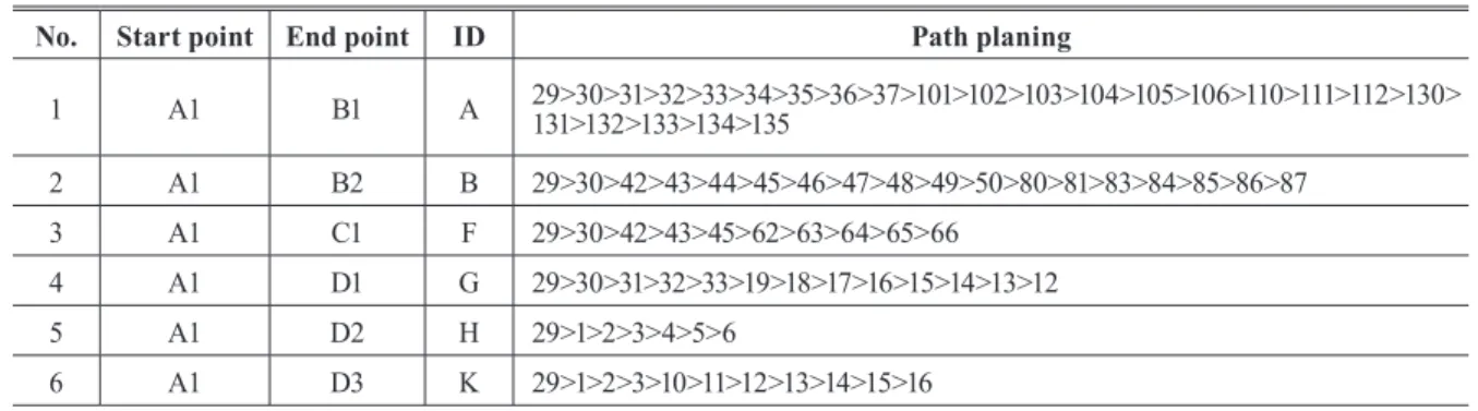
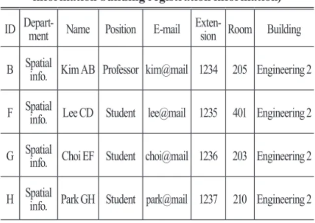
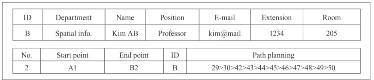
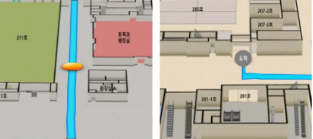
As a result of the study, "0001.xml" corresponding to the file index key value, which is the service connection information in the building information of the destination, was extracted from the prototype verification of the system, the search word of 'Kim AB' was transmitted to the indoor map server and converted from the outdoor map service to the indoor map service through confirmation of the navigation service connected information, using service linkage information and search words of the indoor map service was confirmed that the route was displayed from the entrance of the building to the destination in the building through the linkage search DB (Database) table and the search query. Therefore, through this study was examined the possibility of linking indoor and outdoor DB through vector spatial information integration service system. The indoor map and the map engine were implemented based on the same vector map format as the outdoor map engine, it was confirmed that the connectivity of the map engine can be applied.
Keywords : Indoor Spatial Information Service, Building Object Information, Indoor Map Service, Integration Service of Spatial Information
Original article
Received 2018. 06. 12, Revised 2018. 06. 25, Accepted 2018. 06. 28
1) Member, Dept. of Realty, Daegu University (E-mail: [email protected])
2) Corresponding Author, Member, Dept. of Real Estate, Semyung University (E-mail: [email protected])
This is an Open Access article distributed under the terms of the Creative Commons Attribution Non-Commercial License (http://
1. Introduction
Today, outdoor navigation map services are widely available in a variety of functions, and many efforts are also being made to provide services for indoor spatial information. Recently, the complexity of diversification of indoor space due to the construction of cutting-edge cities such as U-City (Ubiquitous City), U-Ecocity, smart-city has added additional temporal and economic costs, demand for location services of indoor spatial is on a gradual increase (Yoon and Hwang, 2015), the navigation is expanding into the indoor spatial and the service for it is perceived as natural.
Also, as shown in the indoor spatial information standard of
OGC (Open Geospatial Consortium) and in the technology trends related to various outdoor web services, it is expected to enter into the era of indoor and outdoor spatial information integration service (Kwon and Kim, 2013).
Based on the CityGML, the OGC's three-dimensional
city model standard, detail 4 (LOD 4: Level of Detail 4),
the standardization of indoor spatial currently suggests
a geometric and semantic model standard of indoor
spatial (OGC, 2012(a)), by defining the IFC (Industrial
Foundation Classes) as a standard, BuildingSmart refers
to expressing the architectural elements of indoor spatial
(BuildingSMART, 2013). Currently, there are various
types of formats such as GML, KML (Keyhole Markup
variety of map information, thereby improving the quality of the map.
However, previous studies have focused on indoor navigation systems and algorithms rather than on indoor and outdoor spatial information services (Kim et al., 2014; Zhou et al., 2013). The studies on the vector map implementation have been very limited so far. There is little study on the vector map implementation using the GeoJSON format, which facilitates capacity minimization, smooth customization, and exchange of objects between different systems, in order to complement the disadvantages of the various spatial information formats mentioned above. Also, it is difficult to find the previous studies that integrate indoor and outdoor into one service.
Therefore, in this study, as an early stage for integrating indoor and outdoor individual spatial information systems and applying a unified service, to express an integrate various indoor map formats such as GML, KML, IFC, GeoRSS. It can fully support real life patterns and different formats of outdoor maps, such as binary, raster data, etc., utilized in most commercial navigation which indoor and outdoor maps were designed with GeoJSON, an unified engine was applied.
Also, for the purpose of verifying interrelated search of different indoor and outdoor, by verifying and reproducing the hypothetical scenario, setting the departure point based on the outdoor map service and set the destination in the indoor map data, the applicability of vector spatial information integration service system has been shown.
2. Service Design and Construction
2.1 Service design process
In this study, for spatial services related to separately existing indoor and outdoor services as shown in Fig. 1, through the establishment of integrated spatial information service between two services by finding a common link, it tried verify the possibility of providing as an indoor and outdoor integrated spatial service.
The indoor spatial information was constructed around the 2nd building of the engineering College, Kyungpook National University. The outdoor information was linked with the navigation data using Mappy of MN soft company.
Language), IFC, GeoJSON, and GeoRSS to represent indoor spatial among these, OGC of CityGML and IndoorGML is defined as standard (OGC, 2012(b); OGC, 2014). CityGML is limited in the representation of detailed connectivity and topological connectivity in offices, corridors. There is a limit to the search of indoor spatial and the analysis of spatial (Li and Lee, 2013). IndoorGML is intended to represent walls, doors, stairways, etc. of objects existing in 3-dimensional indoor spatials of other indoor and outdoor buildings, but there is a limit to expressing all contents independently (Li et al., 2015). For these reasons, Given that GML is not well utilized in a variety of spatial information web applications as an international standard that may be of great interest to many general users. JSON is easier to handle than based XML (Extensible Markup Language) data formats, because of Javascript, its performance is also known to be good (Park and Lee, 2008).
Until recently, it is only possible to access geographic
information that adds vector geographic information of WFS
(Web Feature Service) to image-based WMS (Web Map
Service) and it is a fact that there are limitations in the bird
view such as 3D expression which is the basic use of the map,
new backgrounds at enlargement and reduction, modification
and customization of background data. Namely, Because it is
a format that expands data from XML base for the purpose
of expressing spatial information as a vector form to support
specific geographic information. It takes up a lot of data
spatial, although some types of information such as buildings
and such services as roads, route lines and tracking can be
expressed. It has a partial limitation because it requires a very
large amount of data to display a lot of information at one
time like an actual map. To overcome the disadvantages of
service linkage, display capacity, and customization for user
convenience. There are a lot of studies related to algorithms
and systems for linking smooth web services in various
formats such as GML, KML, GeoJSON, and GeoRSS (Han,
2014; Kim et al., 2013). Among them, GeoJSON format
allows user to directly modify, insert and update information
of original map data and customize it, that can share various
information expressions as object-based text, by eliminating
unnecessary tags and header information. It can reduce the
size of the map to speed up the map display and include a
First, regarding the system design, the outdoor service such as navigation were designed through function buttons and service linkage engine module that could be linked with indoor service, the indoor service extracts the same attributes as the outdoor spatial and creates a link to connect the spatial information.
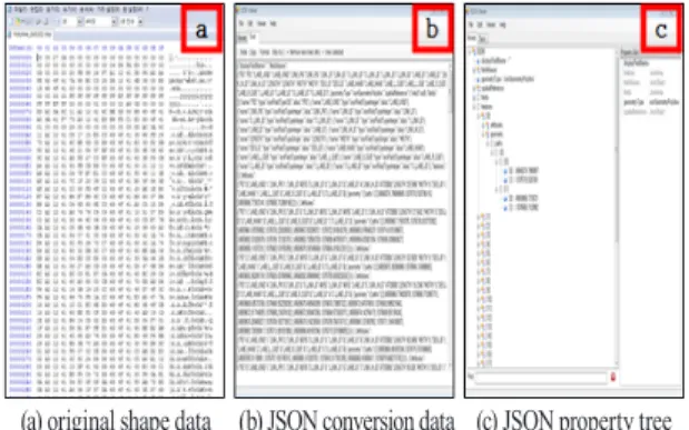
And leveraging GeoJSON's ease of insertion, deletion, and customization of information, by inserting the connection information of the indoor outdoor map, by removing unnecessary information other than attribute information and graphic information and by reducing the size of the map, it optimized the map display performance. GeoJSON is a geospatial data interchange format based on JavaScript object notation, it is very advantageous in the web environment because it adopts the syntax of JavaScript. In addition, GeoJSON is composed of text that is easy for human to read and write. Programming language and platform are independent of each other, for that reason make it easy to exchange objects between different systems. As shown in Fig. 5, the map is minimized by constructing object, which is the minimum information that can be displayed, point/line/
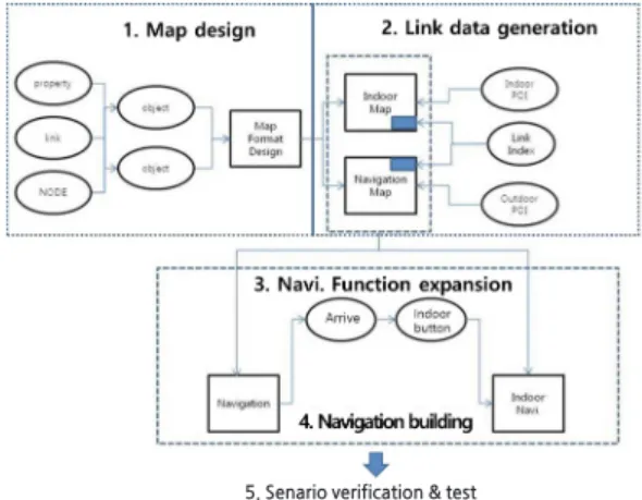
plane information and coordinate information. In this study, the steps for outdoor service, indoor service, indoor/outdoor spatial information connection are verified by spatial object unit, and it linked this to all the services. The flow chart of the design is shown in Fig. 2.
2.2 Indoor map design
First, the target building for the indoor map design was Kyungpook National University Engineering Building No. 2 in Sangyeok-dong, Buk-gu, Daegu. To build indoor spatial information, it is necessary to filter each layer by using the digital map and the architectural drawing. The geometry and position of Kyungpook National University Engineering Building No. 2 were extracted from coordinate information of points, lines, and planes from the drawing. And by securing the attribute data that could represent the indoor spatial, the attributes for the points, lines, and faces of the extracted information were defined, then they converted to data that could be served through re-filtering.
Using QGIS 2.1.4 version as shown in Fig. 3, the objectized numerical data constructed from the shape file was converted. And using objectified service groups was possible to utilize services such as indoor route search through the building details and the departure/destination setting. Also, all extracted point, line, and plane information were used as a graphic group for viewers, and information that could be used as a service in a graphic group was classified as a service group. Here, the graphic group means coordinate information that can form points, lines, and faces, and the service group refers to objectized data of linear and planar shapes composed of coordinate information.
Fig. 1. Service design purpose
Fig. 2. The flow chart of study design
5. Senario verification & test