1) Department of Civil Engineering, Pusan National University
급경사지방재를 위한 급경사지정보 및 지하공간정보 DB 구축과 활용 방안 연구
Construction and Utilization Plan of Steep Slope and Underground Spatial Information DB for Steep Slope Disaster Prevention
이 경 철
1)
・ 장 용 구†
・ 송 지 혜1)
・ 강 인 준1)
Kyungchul Lee ・ Yonggu Jang ・ Jihye Song ・ Injoon Kang
Received: March 18
th, 2014; Revised: April 1
st, 2014; Accepted: April 28
th, 2014
ABSTRACT : Recently, a great number of natural disasters have more frequently happened than the past. The National Emergency Management Agency of Korea has made preparation for the integrated management system of steep slope lands. There is information based on the steep slope inspection sheets and the underground spatial information related to the prevention against steep slope disasters. Nevertheless, building a complete DB System to prevent the hazards and secure the safeties should be urgently dealt with.
It is mainly because the information of the National Disaster Management System is restricted to the text-based brief data. Therefore, the purpose of this study is to suggest the method as to building steep slope DB system for disaster prevention and maximizing the availabilities. This study shows the way of building a web-based DB system having its root in the steep slope inspection sheets.
The method of establishing the ideal DB system that has liaisons between the Ministry of Land, Infrastructure and Transport and the National Emergency Management Agency is discussed in this study. Furthermore the optimization of DB utilization will assist the various integrated steep slope management systems based on U-IT which are ongoing projects.
Keywords : Steep Slope, Disaster Prevention DB, Underground Spatial Information, Steep Slope Inspection Sheet, MLIT, NEMA
요 지 : 최근 우면산 산사태, 춘천지역 산사태, 황령산 터널 입구 산사태 등 국내의 급경사지 붕괴에 따른 사고가 빈번히 발생하고 있으며, 그 규모가 점차 커지고 있는 추세이다. 또한 이에 따른 인명・재산피해가 증가하고 있다. 이에 따라 소방방재청에서는 급경 사지 방재를 위한 DB 구축을 통하여 급경사지 붕괴 예측 및 신속한 대응체계 구축을 위한 급경사지 통합관제시스템 구축을 추진하 고 있다. 급경사지 방재와 관련된 정보로는 급경사지 일제조사서를 기반으로 한 사면정보와 지반, 지질 등의 지하공간정보가 있으 며, 이 중 국가재난관리시스템을 통한 텍스트 기반의 간단한 급경사지 정보 외 나머지 정보는 구축되어 있지 않아 급경사지 방재 DB 구축이 매우 시급한 실정이다. 따라서 본 연구에서는 급경사지 방재 DB 구축방법과 활용방안을 제시하였다. 급경사지 방재 DB 중 급경사지 일제조사서 기반의 사면 DB는 기존 일제조사서의 문제점 분석을 개선한 급경사지 일제조사서를 기반으로 하는 웹 급경사지 입력시스템을 통한 DB 구축방법을 제시하였으며, 지하공간정보의 경우 국토교통부(국토지반정보 통합 DB 센터)와 소방방재청(국가지진방재 통합정보시스템) 사이의 지하공간정보 실시간 연계체계로 관리되는 지진방재용 지하공간정보 중 급경사 지 부분의 지하공간정보 DB 구축방법을 제시하였다. 또한 급경사지 방재 DB의 활용방안은 현재 소방방재청에서 구축 중인 U-IT 기반의 급경사지 통합관리시스템, 급경사지 붕괴 위험도 판단시스템 등으로의 활용방안을 제시하였다.
주요어 : 급경사지, 방재 DB, 지하공간정보, 급경사지 일제조사서, 국토교통부, 소방방재청 Journal of the Korean Geo-Environmental Society
15(7): 13~21. (July, 2014) http://www.kges.or.kr
ISSN 1598-0820 DOI http://dx.doi.org/10.14481/jkges.2014.15.7.13
1. 서 론
1.1 연구의 배경 및 목적
오늘날 국제적 산업화와 더불어 온실가스 배출증가로 인 한 지구 온난화의 영향으로 강우강도 및 다발성 집중호우 증가 등 기후변화가 점차 심화되고 있는 추세이다. UN 산 하 세계기상기구(IPCC, Intergovernmental Panel on Climate Change)에서 밝힌 IPCC 5차 보고서에도 기후변화의 영향
이 예상보다 심각하고 강력하게 발생할 것으로 예측하고 있 으며, 이러한 내용을 반영하여 소방방재청에서는 강화된 기 후조건으로 「국가 방재기준 Guideline」을 최근 개정・공표 하였다(National Emergency Management Agency, 2013b).
근래에 발생한 우면산 및 춘천지역 산사태 등의 사례에 서 보듯이 도시화, 산업화가 가속화됨에 따라 과거에 비해 급경사지 재해의 발생빈도와 피해규모는 점차적으로 증가 추세에 있다(Park, 2010). 하지만 이러한 산사태 피해의 원 인이 천재지변(天災地變)인지 예고된 인재(人災)인지에 대
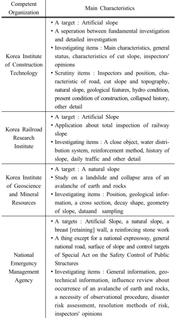
Table 1. Important Features about sleep Slope Investigation Competent
Organization Main Characteristics
Korea Institute of Construction
Technology
∙ A target : Artificial slope
∙ A seperation between fundamental investigation and detailed investigation
∙ Investigating items : Main characteristics, general status, characteristics of cut slope, inspectors' opinions
∙ Scrutiny items : Inspectors and position, cha- racteristic of road, cut slope and topography, natural slope, geological features, hydro condition, present condition of construction, collapsed history, other detail
Korea Railroad Research
Institute
∙ A target : Artificial Slope
∙ Application about total inspection of railway slope
∙ Investigating items : A close object, water distri- bution system, reinforcement method, history of slope, daily traffic and other detail
Korea Institute of Geoscience and Mineral
Resources
∙ A target : A natural slope
∙ Study on a landslide and collapse area of an avalanche of earth and rocks
∙ Investigating items : Position, geological infor- mation, a cross section, decay shape, geometry of slope, dataand sampling
National Emergency Management
Agency
∙ A targets : Artificial Slope, a natural slope, a breast [retaining] wall, a reinforcing stone work
∙ A thing except for a national expressway, general national road, surface of slope and control targets of Special Act on the Safety Control of Public Structures
∙ Investigating items : General information, geo- technical information, influence review about occurrence of an avalanche of earth and rocks, a necessity of observational procedure, disaster risk assessment, resolution methods of risk, inspectors' opinions
한 논란은 지금도 계속되고 있다. 이러한 관점에서 급경사 지 재해방재를 위한 객관화되고 체계적인 재해 대응체계 마 련은 국가적으로 시급한 중요 과제이며, 아울러 급경사지 방재 DB를 활용한 방재 시스템의 확대・개선을 통해 급경사 지 재해로부터 국민의 생명과 재산을 보호하고 공공복리를 증진시키는 데 도움을 줄 것이다.
현재 소방방재청에서 운영 중인 국가재난관리시스템(NDMS, National Disaster Management System) 현황을 분석하면, 텍 스트 기반의 간단한 급경사지 정보만 구축되어 있고, 나머 지 정보는 입력되어 있지 않아 방재 DB의 체계적 구축이 시급하다. 또한 구축 중인 급경사지 일제조사서가 급경사지 의 특성을 객관화하지 못해 정확한 급경사지 정보 구축이 어렵다는 문제점을 가지고 있다.
이에 따라 본 연구에서는 기존 급경사지 방재 DB 일제조 사서의 문제점을 개선하여 새로운 일제조사서 양식을 활용한 웹 기반의 급경사지 입력시스템 DB 구축방법을 제시하고, 지하공간정보의 실시간 연계체계로 관리되는 지진방재용 지 하공간정보 중 급경사지 부분의 지하공간정보 DB와의 통합 을 통해 급경사지 방재 DB의 활용성을 제시하고자 한다.
1.2 연구동향
방재를 위한 DB 시스템에 대한 국내・외 연구동향을 살 펴보면 다음과 같다.
국내의 경우 급경사지 관리 및 활용에 대해 한국건설기 술연구원과 한국시설안전공단이 도로절토사면 유지관리시 스템(CSMS, Cut Slope Management System)를 운영하고 있 으며, 도로교통연구원의 경우 고속도로 절토사면 유지관리 시스템(HSMS, Highway Construction & Maintenance System) 을 고속국도 절토사면을 대상으로 운영하고 있다. 또한 한국 철도기술연구원은 철도주변절토사면 유지관리시스템, 한국 지질자원연구원은 자연사면 산사태 유지관리시스템을 운영 하고 있는 등 기초적으로 필요한 지질 및 지반자료를 각 기관 별로 관리 및 현황을 조사・분석하고 있다. Table 1은 관할기 관별 급경사지 조사의 주요 특징을 나타낸 것이다(National Emergency Management Agency, 2013a).
국외의 경우 미국의 미국지질조사소는 국가 지질도 데이 터베이스를 구축하여 지질, 재해, 급경사 정보, 지하자원, 지 구물리, 지구화학, 지사, 고생물, 해양지질 등의 정보를 관리 하며, 단독 서버가 아닌 각 주와 연계하여 서비스를 제공하 고 있다. 독일의 경우에도 LBEG(Landesamt fur Bergbau, Engergie und Geologle)를 주별로 운영하며 급경사지 정보 를 포함하여 광산지역, 시추정보, 토지이용, 지질, 지열, 수 리지질, 천연자원 등의 다양한 정보들의 관리가 이루어지고
있다. 일본 역시 JAMSTEC(Japan Agency Marine-earth Science and Technology), GSJ(Geological Survey of Japan) 등에서 급경사 정보, 해안시추정보, 지질, 화산, 지진, 지역, 지구물리 정보 등 다양한 자료를 구축 관리한다(National Emergency Management Agency, 2013a).
국내・외 연구동향을 조사한 결과 국내의 경우 각 기관별 로 사면정보만을 위주로 하여 자체적으로 정보를 수집・관 리하고 있어 보다 정밀한 사면정보 및 사면방재를 위한 체 계가 미흡한 것으로 조사되었다. 그러나 국외 사례의 경우 사면정보뿐만 아니라 지하공간정보를 통합 관리하는 시스 템이 국가적 차원에서 구축되어 있어 정보 활용에 대한 효 율성이 굉장히 높은 것으로 조사되었다. 이에 따라 각 기관 이 가지고 있는 지하정보들을 사면정보와 연계함으로써 더 욱 효율적이고 경제적인 자료의 관리 및 적용이 이루어질 것으로 보여 본 연구의 타당성을 확인할 수 있었다.
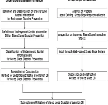
Fig. 1. diagram about research methods
Table 2. Investigating Items Conforming to the Law about Prevention of Steep Slope Disasters
Investigating items
∙ Position and present condition of steep slope
∙ Designated reason as a danger zone of collapse
∙ Residents opinion about designation as a danger zone of collapse
∙ Disaster risk assessment
- Height, a gradient, collapsed history and so on
- Distance of surrounding environment and a public establishment (a social influence)
1.3 연구방법 및 범위
본 연구에서는 웹 기반의 급경사지 방재 DB 구축을 위해 현 상황의 문제점을 개선하고 기존 DB의 활용성을 극대화 할 수 있도록 연구범위를 설정하였다.
급경사지 방재와 관련한 정보로는 크게 두 가지로 구분 된다. 국가재난관리시스템상의 급경사지 일제조사서를 기 반으로 한 사면정보와 급경사지 지역 내의 지반, 지질 등의 지하공간정보가 바로 그것이며, 이러한 현실적인 여건이 효 율적으로 개선・반영될 수 있도록 본 연구의 범위를 다음과 같이 설정하였다.
첫째, 급경사지 DB의 경우 기존의 급경사지 일제조사서 를 기반으로 한 방재 DB가 통합 텍스트 기반의 매우 간단 한 급경사지 정보만을 담고 있고, 내용의 중복 및 부적합 등 의 문제점을 가지고 있는 실정으로 본 연구에서는 이러한 문제점을 분석하여 개선된 급경사지 일제조사서를 웹 기반 의 급경사지 시스템을 통해 입력이 가능하도록 하는 방재 DB 구축방법을 제시하였다.
둘째, 지하공간정보 DB의 경우 실시간 연계체계로 관리 되는 국토교통부(국토지반정보 통합 DB 센터)와 소방방재 청(국가지진방재통합정보시스템) 사이의 지진방재용 지하 공간정보 중 급경사지 부분의 지하공간정보를 활용・연계한 DB 구축방법을 제시하였다.
마지막으로 본 연구에서는 우리나라 급경사지의 특성과 방재를 위한 정보의 종류를 파악하고 각 기관별로 관리되고 있는 지하공간정보(시추정보, 지질정보, 광산정보, 관정정 보) 및 급경사지의 구축범위를 결정하였으며, 향후 급경사
지 방재시스템 구축을 위한 방향성과 급경사지 방재 DB의 활용성을 제시하였다.
연구의 방법은 급경사지 DB 구축분야와 지하공간정보 DB 구축분야로 구분하여 진행하였으며, Fig. 1은 본 연구의 연구방법의 흐름도를 보여준다.
2. 기본이론
2.1 우리나라의 급경사지 특성
우리나라는 급경사지 재해예방에 관한 법률에 따라 급경 사지란 택지・도로・철도 및 공원시설 등에 부속된 자연 비탈 면, 인공 비탈면(옹벽 및 축대 등을 포함한다.) 또는 이와 접 한 산지로서 대통령령으로 정하는 것을 말하며, 자연비탈면 은 지면으로부터 높이가 50 m 이상이고, 경사도가 34° 이 상, 인공비탈면은 높이가 5 m 이상이고, 경사도가 34° 이상 이며 길이가 20 m 이상인 것으로 정의하고 있다(National Emergency Management Agency, 2013a).
또한 급경사지 지정 시 조사되는 항목에는 급경사지 재해예 방에 관한 법률 제6조 제1항에 따라 위치 및 현황, 붕괴 위험 지로 지정하는 사유, 재해위험도평가 결과보고서 및 붕괴위험 지역 지정에 대한 주민 의견 등이 있다(National Emergency Management Agency, 2013a). 특히 재해위험도 평가 결과보 고서는 급경사지의 높이, 경사도, 붕괴이력 등 붕괴위험성과 주변 환경, 공공시설 등과의 거리 등 사회적 영향에 대한 조사 가 실시되고 있다(National Emergency Management Agency, 2013a). Table 2는 급경사지 재해예방에 관한 법률에 따른 급경사지 조사항목을 나타낸 것이다.
그러나 급경사지 재해예방에 관한 법률에 의하여 급경사 지 관리를 위한 전수조사가 일시에 이루어지지 않았기 때문 에 전국에 분포하고 있는 급경사지의 개수는 계속해서 증가 할 것으로 판단된다(National Emergency Management Agency, 2013a). Table 3은 급경사지 관리법에 따른 우리나라 급경 사지 현황(2013년 5월 기준)을 나타낸 것이다.
Table 4. Main problems of existing Steep-slope Inspection sheet
Classification Content
Whole Composition of Sheet
∙ Natural Slope, Artifact Slope, Breast (Retaining) Wall Survey through Same Inspection Sheet
Investigating Items
∙ Low Necessity or Difficult Items to Survey - Classification of Slope Face Type (Ground,
Forest Land), Scale of Expected Damage
∙ Doubleness and Inconcinnity of Research Category
- Doubleness : Condition of facilities for Protection (Necessity)
- Inconcinnity : Upper External Force (Poor Drainage)
Table 5. Department Person’s Main Opinion about Improvement of Steep-slope Inspection Sheet
Institution Anyang-si
Main Opinion
∙ It is very easy-to-use
∙ Steep slope of private possession is managed as a disaster facility
∙ It is hoped that enrollment of slope possession and managing body will be possible about private possession
Institution Wonju-si
Main Opinion
∙ Subdivision of investigating items
∙ Vegetation state survey of slope
∙ Survey of continuity about a surface of discontinuity in artifact slope
Institution Mokpo-si
Main Opinion
∙ Management object of steep slope is too wide
∙ Use of simple terms or explanation of term
Institution Gunsan-si
Main Opinion
∙ Improvement as user centered form
∙ Connection with disaster risk assessment table is necessary
Table 3. Steep Slopes Status of Domestic
No. Classification Quantity
1 Seoul 290
2 Incheon 232
3 Daegu 151
4 Busan 699
5 Gwangju 132
6 Ulsan 281
7 Daejeon 209
8 Gyeonggi-do 1,038
9 Chungcheongnam-do 355
10 Chungcheongbuk-do 1,256
11 Gangwon-do 2,346
12 Jeollabuk-do 1,120
13 Jeollanam-do 1,285
14 Gyeongsangbuk-do 1,082
15 Gyeongsangnam-do 3,085
16 Jeju-do 38
Total 13,599
2.2 급경사지방재 정보 현황
현재 우리나라의 급경사지 방재 DB에는 지진방재용 지 하공간정보와 급경사지 정보가 있으며, 이 중 급경사지 방 재를 위한 지하공간정보에는 지질정보, 지반정보, 광산정보, 지하수정보가 있다(National Emergency Management Agency, 2013a). 그러나 이들 정보가 기관별로 조사・관리되고 있어 정확한 급경사지 방재 DB가 구축되지 못하고 있는 실정이 다. 따라서 이러한 문제를 해결하기 위해서는 급경사지 지 역에 해당하는 지하공간정보 DB와 급경사지 DB의 통합이 필요할 것으로 판단되었다.
또한 급경사지 방재 DB를 구축하기 위해서 소방방재청 에서는 급경사지 일제조사서를 제공하고 있으며, Fig. 2는 현재 소방방재청에서 제공하고 있는 일제조사서이다. 그러 나 현재 소방방재청에서 제공하고 있는 일제조사서는 인공, 자연비탈면, 옹벽, 석축 및 고속국도, 일반국도비탈면, 시설 물 안전관리에 관한 특별법 관리 대상 비탈면을 제외한 비 탈면을 대상으로 하고 있다. 주요 조사 항목으로는 일반정 보(위치, 제원 등), 지반정보(결함인자, 피해인자), 토석류 발생 영향성 검토, 계측관리 필요성, 재해위험도 평가, 위험 해소 방안, 조사자 의견 등이 있다.
3. 급경사지 및 지하공간정보 DB 구축 범위 결정
3.1 급경사지 DB 구축 범위 결정
급경사지 DB 구축 범위 결정을 위하여 기존의 급경사
지 일제조사서 양식을 분석함으로써 문제점을 도출하였으 며, 지자체의 급경사지 담당자의 요구사항을 급경사지 일제 조사서의 개선된 양식에 수렴하기 위한 조사를 진행하였다.
현재 소방방재청에서 제공하고 있는 기존의 급경사지 일 제조사서를 조사한 결과 동일한 조사양식(항목)을 활용하여 자연, 인공급경사지, 옹벽(석축)에 대해 이루어지고 있고, 필요성이 낮거나 조사하기 어려움이 있는 항목들이 포함되 어있었다. 또한 조사 항목의 중복성과 부적합 등의 문제점을 가지고 있어 정확한 급경사지 DB를 확보하기 위해서는 급경 사지 일제조사서의 개선이 시급한 것으로 나타났다(National Emergency Management Agency, 2013a). Table 4는 기존의 급경사지 일제조사서의 주요 문제점을 나타낸 것이다.
또한 지자체 급경사지 담당자에 대하여 개선안에 대한 의견수렴을 위한 조사를 수행하였다. 의견서의 조사 항목으 로는 급경사지 조사의 어려움, 기존 급경사지 사용의 문제 점 및 개선사항, 급경사지 관리 업무와 관련한 기타 의견 등
G r o u n d I n f o
Inspector Belonging Disaster and safety department
Position
Contact
Office
Name Cell phone
Inspection date
Feb. 13, 2012Place
Administrative district (Code No.)
city·province city·gun·gu eup·myeon·dong ri·dong street address (02) - ( 06 ) - (Bokcheon-dong) - (ri·dong) -(mountain 1-1)
Management place name
near Woosung apartment, Bokcheon-dong
GPS coordinate Starting point: latitude ( 35° 12′30.78″),longitude(129° 05′ 16.80″) End point: latitude ( 35° 12′30.84″),longitude(129° 05′ 18.59″)
Management authority Corporation Use of slope face
(protection object)
①road (lane (지,군,비)②apartment ③house
④industrial complex ⑤park ⑥other( )
Data
Type of slope face
Land ①artificial slope
②natural slope
Slope face structure
①face of earth and sand
②concrete revetment
③stone work revetment
④rock slope ⑤other( ) Forest land
(mountain area)
①artificial slope
②natural slope
Top altitude 22 (m) Longitudinal length 45(m)
Average slope 1 : 1.36(36°) Side gutter of ridge ①yes(structure: ) ②no Collapse record ①occurred in the year of ( ) ②no
※type of collapse:
construction year of artificial slope face
year
( constructor : ) Protection facility status ①good ②bad ③very bad ④no ⑤necessity in its absence(yes/no)
G r o u n d I n f o
Flaw factor
Slope of earth and
sand ①tension crack ②scour, subsidence③poor drainage ④bump ⑤kinetic phenomenon ⑥loss of topsoil,※depth of soil stratum ( )m Underground water
status ※within slope face ①totally dry ②humid ③wet ④falling ⑤flowing ※rain influence of upper slope(yes/no) Soil strength ①very solid ②dense or solid ③middle ④loose or weak ⑤very loose
drainage status ①good ②bad ③no ④enlargement ⑤reconstruction or need of construction ⑥other( )
Revetment Concrete:①crack( )mm ②transmission ③subsidence ④activity ⑤poor drainage ⑥peeling-off ⑦other( ) stone work:①full ②crack( )mm ③transmission ④subsidence ⑥stone deviation ⑦poor drainage ⑧other( ) Bedrock ①fault ②discission(inner direction, outer direction, levelness, other) ③loose stones ④aeration degree(good/fair/poor) Discission direction ①very advantageous ②advantageous ③good ④disadvantageous ⑤very disadvantageous
Slope phenomenon ※traverse:①straight line ②concavity ③convexity ④ribbed ※verticality:①straight line ②concavity(凹) ③convexity(凸) ④ribbed Valley info ①valley yes(within slope) no ②valley extension(15)m ③valley width(2)m ④other
Vegetation density ※tree: ①good ②fair ③poor ※herbaceous plant: ①good ②fair ③poor Status of surface
protection work ①very good ②good ③poor ④very poor ⑤no surface protection work ⑥need of surface protection work Occurrence part of
gushout water ①upper part ②middle part ③lower part ④no External force of upper
part ①building ②steel tower ③farmland ④railroad ⑤cemetery ⑥trench ⑦poor drainage ⑧other Type of expected
collapse ①large scale ②middle scale ③small scale ④surface loss ⑤stone slide, rock slide ⑥stone( )
Damage factor
Separation distance separation distance between slope and down-stream dwelling: 50m, separation distance between down-stream rivers: m separation distance between slope and public facilities : m, main facilities
Scale of expected
damage building , household / farmland ha/ road km/river km/, car
Influence check for occurrence of avalanches
Lay of surrounding land ①mountain area ②hill area ③plain area ④other / ※possibility of avalanches occurrence ①yes ②no Dangerousness of
down-stream river
avalanches-inflow stream in collapse: a downstream river m located from the collapse danger area ①national stream, ②local stream, ③small stream, ④abnormal stream)
Damage of expected
avalanches building , household / farmland ha/ road km/river km/ other( )
Necessity of measuring management ①need of measuring (reason : ), ②no need of measuring ③measuring instrument: yes/no (management: ) Evaluation of disaster dangerousness ①A ②B ③C ④D ⑤E ※evaluation score (50) ; evaluation chart of natural slope face
Method of danger solution ①reinforcement method ②removal of dangerous avalanches ③moving measures ④선형개량 ⑤other( )
Maintenance plan size of business business expense(million won)
Designation of natural disaster risk district
①designation date( . . )
②no designation Propelling of repair business
after district designation
①already completed
②during propelling
③no propelling Designation of collapse danger zone ①designation date( . . )
②no designation General opinion of inspector
Division Belonging Position Name Contact
Inspector Inspector Checker
Fig. 2. Existing Steep-slope Inspection sheet
I n f o g e n e r
Inspection date Month day year
Location
Administrative district / Code No.
city·province city·gun·gu eup·myeon·dong ri·dong street address / (02) - ( 06 ) - (Bokcheon-dong) - (ri·dong) -(mountain 1-1)
latitude and
longitude oordinate latitude( 35° 12′ 30.78″), longitude(129° 05′ 16.80″) Kinds of slope area ①natural slope face/mountain area
②artificial slope face ③revetment/embankment construction year peripheral topography ①mountain area ②hill ③plain
④other Peripheral feature
C l a s s I f I c a t I o n o
f s t e e p
╷ s l o p e s I t e
Natural slope face/Mountain area Artificial slope face Revetment/Embankment
Height m Extension m Kind
①bedrock ②mixing③soil and sand
Kind
①concrete
②embankment
③reinforced soil
④gabion⑤other( )
Average
slope
Soil stratum
depth m Height m Extension m Height m Exten
sion m Longitudinal
feature
①convexity ②straight line
③concavity ④complex
Average slope Subsiden
ce
①no ②minor
③partially occurrent
④severe ⑤very severe
Traverse
feature
①descending style
②parallel style ③ascending style ④complex style
Aeration degree
①weak ②normal
③severe
Scouring
①no ②minor
③partially occurrent
④severe ⑤very severe
Valley part
①no ②yes no.( )
Vertical shape
①convexity ②straight line③concavity ④complex
Being full
①no ②minor ③partially occurrent
④severe ⑤very severe
extensio
n m width m Traverse shape
①straight line ②concavity
③convexity ④concavo-convex
⑤lower part's breakaway type
⑥extruded type
Front damage
①no ②minor
③partially occurrent
④severe ⑤very severe
Underground
water status
①dry ②humid ③wet
④dribbling ⑤flowing
Underground water status
①dry ②humid ③wet
④dribbling ⑤flowing
Drainage
①very good ②good ③poor④very poor ⑤no
External force
of upper part
①no ②farmland, cemetery
③transmission tower, house
④railroad ⑤road
⑥woodland path ⑦other
Direction of discontinuous
face / Strength of soil
(choose 1)
①very advantageous
②advantageous ③good
④disadvantageous
⑤very disadvantageous
Collapse
record
①yes(occurrence year : ,collapse type:)
②no
①very solid ②solid ③normal ④ loose
⑤very loose
Security facility
①very good ②good
③poor ④very poor
⑤no
Collapse record
①yes(occurrence year : , collapse type: )
②no
Security facility
①very good ②good③poor ④very poor ⑤no
Drainage
①very good ②good③poor ④very poor ⑤no
E v a l u a t I o n a n d o p I n I o n
Influence of steep-slope collapse damage
Surrounding environment
①road ②railroad ③house lot ④park ⑤forest landExpected casualty
①0 ②1∼4 ③5 and moreRoad damage(lane)
①double-lane ②four-lane ③six-lane and moreDistance from private houses and public
facilities
( ) mInfluence of
avalanches damage
Occurrence possibility ①yes ②attention demand ③no
Expected damage ①house and building ②farmland ③road ④stream ⑤other ( )
Inspector opinion
Evaluation of disaster risk level
Grade A B C D E
evaluation score
st a t u s M a n a g e m e n t
Measuring management
①need of measuring ②needlessness of measuring ③during measuring managementPolicy method
①surface security method②removal of danger factor ③reinforcement method ④moving measure ⑤present condition maintenanceMaintenance plan
Business amount business expense (million won)Designation of natural disaster risk district
①designation date( . . )②not designated
Repair business
propelling after district designation
①already completed
②during propelling
③not propelled
Designation of collapse risk district
①designation date( . . )②not designated
Division Belonging Position Name Contact
Inspector Confirmor
Fig. 3. improved Steep-slope Inspection sheet
Table 6. Data Construction Range for Steep-slope Management and prevention of disaster
Establishment Required Data List Korea Institute of
Geoscience and Mineral Resources
∙ Geologic Map
Korea Mineral Resources Corporation
∙ Exploratory Hole, Rock Columna Data and Boring Logs
Korea Institute of Construction Technology
∙ General Bore Data, Geological data, General material Data, Site Investigation Data and Laboratory Investigation Data Korea Rural Community
Corporation・Korea Water Resources Corporation
∙ Underground Water Depth and Water Level
Table 7. Table Categories base on improved Steep-slope Inspection sheet
No. Table ID Table
1 SLOPE_GENERAL Steep Slope General Data
2 SLOPE_NATURAL Natural Slope
3 SLOPE_ARTIFICIAL Artifact Slope
4 SLOPE_WALL Breast/Retaining Wall
5 SLOPE_EVALUATION Assessment and Opinion 6 SLOPE_MANAGEMENT Management Condition 7 SLOPE_PICTURE Photograph Information
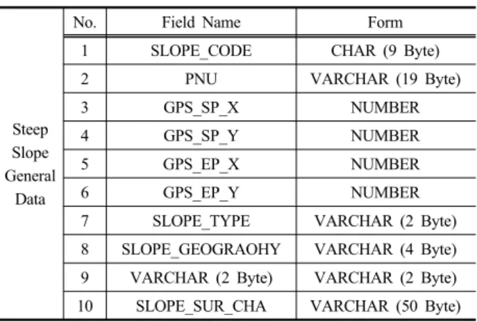
Table 8. Plan of Standard Input DB base on improved Steep- slope Inspection sheet
Steep Slope General
Data
No. Field Name Form
1 SLOPE_CODE CHAR (9 Byte)
2 PNU VARCHAR (19 Byte)
3 GPS_SP_X NUMBER
4 GPS_SP_Y NUMBER
5 GPS_EP_X NUMBER
6 GPS_EP_Y NUMBER
7 SLOPE_TYPE VARCHAR (2 Byte)
8 SLOPE_GEOGRAOHY VARCHAR (4 Byte) 9 VARCHAR (2 Byte) VARCHAR (2 Byte) 10 SLOPE_SUR_CHA VARCHAR (50 Byte)
을 포함하였다. 조사견과 주요 개선사항으로는 불필요한 조 사 내용 및 중복내용의 삭제, 재해위험도 평가표와 일치되 도록 구성, 조사 흐름을 고려한 양식 구성, 자연・인공급경사 지, 옹벽, 축대 등의 구분 등이 있었다. Table 5는 기존의 급 경사지 일제조사서의 개선안에 대한 지자체별 담당자들의 주요 의견을 나타낸 것이다.
또한 Fig. 3은 기존의 급경사지 일제조사서가 가지고 있 던 문제점과 지자체 급경사지 담당자들의 의견을 고려한 개 선된 양식의 급경사지 일제조사서이다.
따라서 본 연구에서는 개선된 급경사지 일제조사서를 기 반으로 하여 급경사지 DB 구축 범위를 설정하였다.
3.2 지하공간정보 DB 구축 범위 결정
지하공간정보 DB 구축 범위를 결정하기 위해서 먼저 지 하공간정보를 기관별로 검토하였다. 검토 결과를 토대로 급 경사지 방재에 활용도가 높은 자료를 도출하였으며, 이를 토대로 구축 범위를 결정하였다. 검토 결과 한국지질자원연 구원에서는 제공하는 지질도, 해저지질도, 광산분포도, 수 리지화학도 등의 정보 중 지질도가 급경사지 방재에 있어 활용도가 높을 것으로 나타났다. 또한 한국광물자원공사에 서 제공하는 시추공내역, 광체정보, 암석주상정보, 시추정 보, 갱내도 등의 정보들 중 시추공내역, 암석주상정보, 시추 주상도의 활용도가 높을 것으로 판단되었다. 한국건설기술 연구원에서는 프로젝트 정보, 지형지질정보, 시추공정보, 지 층정보, 기본 물성 정보, 현장 시험정보, 실내 시험정보 등 을 제공하고 있으며, 그 중 시추공 일반정보, 지층정보, 기 본 물성 정보 등이 활용도가 높은 자료로 분석되었다. 또한 한국농어촌공사와 수자원공사에서 제공하는 관정개발밀도 현황, 지하수심도 및 수위현황, 전기전도도현황, 수맥지구 현황 중 지하수심도 및 수위현황 역시 활용도가 높을 것으 로 판단되었다. 그러나 해양조사원 및 한국수자원공사에서
제공하는 자료들은 급경사지 관리와 연관성이 낮은 것으로 판단되어 지하공간정보 DB 구축 범위에 포함시키지 않았 다(National Emergency Management Agency, 2013a). Table 6은 지하공간정보 중 급경사지 관리 및 방재에 구축할 자료 의 범위이다.
4. 급경사지 방재 DB 설계・구축 및 활용방안
4.1 급경사지정보 DB 설계・구축 방안
급경사지 방재 DB의 구축을 위하여 먼저 DB 설계를 실 시하였다. Table 7은 개선된 급경사지 일제조사서 기반의 개선된 테이블 목록을 나타낸 것이다(National Emergency Management Agency, 2013a).
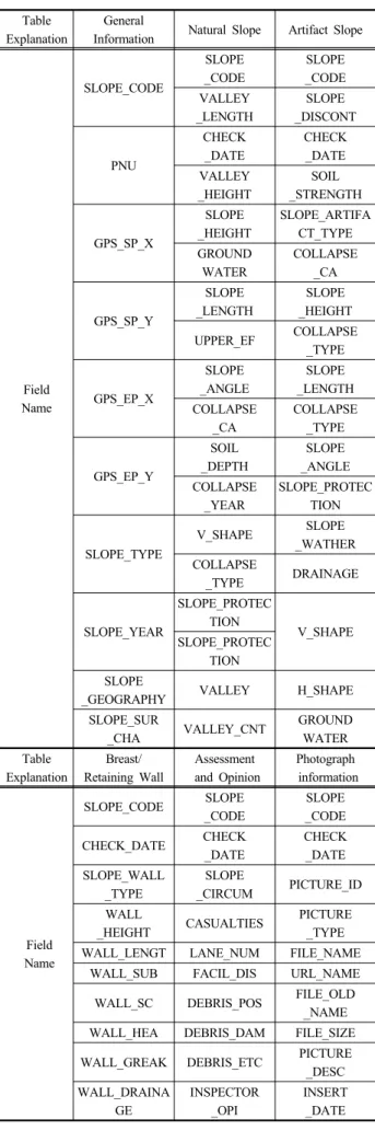
Table 8은 개선된 급경사지 일제조사서 기반의 개선된 테 이블 명세서를 나타낸 것이며, Table 9는 개선된 DB의 일반 정보 및 비탈면 정보를 나타낸 것이다(National Emergency Management Agency, 2013a).
급경사지 방재 DB 구축에 대해서는 급경사지 정보구축 및 관리의 효율성을 위하여 웹을 통해 실시간으로 지자체 에서 급경사지정보를 입력하는 DB 구축 방안을 제시하였
Table 9. Standard Input Table base on improved Steep-slope Inspection sheet
Table Explanation
General
Information Natural Slope Artifact Slope
Field Name
SLOPE_CODE
SLOPE _CODE
SLOPE _CODE VALLEY
_LENGTH
SLOPE _DISCONT
PNU
CHECK _DATE
CHECK _DATE VALLEY
_HEIGHT
SOIL _STRENGTH
GPS_SP_X
SLOPE _HEIGHT
SLOPE_ARTIFA CT_TYPE GROUND
WATER
COLLAPSE _CA
GPS_SP_Y
SLOPE _LENGTH
SLOPE _HEIGHT
UPPER_EF COLLAPSE
_TYPE
GPS_EP_X
SLOPE _ANGLE
SLOPE _LENGTH COLLAPSE
_CA
COLLAPSE _TYPE
GPS_EP_Y
SOIL _DEPTH
SLOPE _ANGLE COLLAPSE
_YEAR
SLOPE_PROTEC TION
SLOPE_TYPE
V_SHAPE SLOPE
_WATHER COLLAPSE
_TYPE DRAINAGE
SLOPE_YEAR
SLOPE_PROTEC
TION V_SHAPE
SLOPE_PROTEC TION SLOPE
_GEOGRAPHY VALLEY H_SHAPE
SLOPE_SUR
_CHA VALLEY_CNT GROUND
WATER Table
Explanation
Breast/
Retaining Wall
Assessment and Opinion
Photograph information
Field Name
SLOPE_CODE SLOPE
_CODE
SLOPE _CODE
CHECK_DATE CHECK
_DATE
CHECK _DATE SLOPE_WALL
_TYPE
SLOPE
_CIRCUM PICTURE_ID WALL
_HEIGHT CASUALTIES PICTURE
_TYPE
WALL_LENGT LANE_NUM FILE_NAME
WALL_SUB FACIL_DIS URL_NAME
WALL_SC DEBRIS_POS FILE_OLD
_NAME WALL_HEA DEBRIS_DAM FILE_SIZE
WALL_GREAK DEBRIS_ETC PICTURE
_DESC WALL_DRAINA
GE
INSPECTOR _OPI
INSERT _DATE
Fig. 4. UI of Steep Slope Management System
Fig. 5. Under Connection diagram Of Underground Spatial Information DB
Fig. 6. DB offer diagram related Steep Slope Disaster Prevention DB
다. Fig. 4는 웹 기반의 급경사지 관리시스템의 UI를 나타 낸 것이다.
4.2 지하공간정보 DB 설계・구축 방안
본 연구에서는 국토교통부의 지반정보, 한국지질자원연 구원의 지질정보, 한국광물자원공사의 탄광정보, 농어촌공 사의 지하수정보, 국립해양조사원의 해저정보를 비롯하여 국토지방정보 통합센터의 시추정보를 VPN망을 통하여 소 방방재청과 실시간으로 연계하는 지하공간정보 DB 구축 방 안을 제시하였다(National Emergency Management Agency,
2013a). Fig. 5는 지하공간정보 DB의 연계 모식도를 나타낸 것이다.
4.3 급경사지 방재 DB 활용 방안
급경사지 방재 DB는 급경사지 방재를 위한 가장 기초적 인 정보로 급경사지 관리분석을 수행하는 모든 시스템으로 정보가 제공・활용된다. 따라서 현재 연구개발 중인 급경사 지 붕괴 위험도 판단시스템 연구, U-IT 기반 급경사지 통합 관리시스템 구축, 급경사지 재해위험지도 개발과 급경사지 주민대피 계측시스템에 활용될 수 있도록 각 시스템의 요구 DB를 분석하여 맞춤형 정보제공이 가능하여야 한다. Fig.
6 은 급경사지 방재 DB와 관련된 시스템 사이의 DB 제공 모식도를 보여준다.
5. 결 론
최근 지구 온난화에 따른 기상이변으로 인한 집중호우 등으로 급경사지의 붕괴가 빈번하게 이루어지고 있으며, 이 로 인한 인적 및 물적 손실 또한 증가하고 있는 추세이다.
이에 따라 급경사지 DB를 구축함으로써 재해를 사전에 예 방하고 선제적으로 대응하려는 움직임이 전 세계적으로 활 발히 나타나고 있다.
이에 본 연구에서는 급경사지 방재를 위한 DB 구축 및 활용에 관한 연구를 수행하였으며, 다음과 같은 결론을 얻 을 수 있었다.
첫째, 급경사지 특성을 고려하여 지하공간정보를 정의,
설계, DB를 구축하는 방법을 제시하였다.
둘째, 급경사지 DB의 경우 기존 일제조사서의 문제점을 분석하여 중복성과 부적합성의 문제점을 해결한 개선된 일 제조사서 기반의 DB 설계 및 구축방법을 제시하였다.
셋째, 구축된 급경사지 방재 DB의 경우 급경사지 붕괴 위험도 판단 시스템 등 급경사지 관리를 위한 관련 시스템 에 기본정보를 제공하는 등 DB 활용성을 제시하여 급경사 지 방재에 대한 기반을 구축하였다.
그리고 향후 급경사지 관리를 위한 체계적인 웹 기반 시 스템 개발을 위한 연구의 지속적인 추진을 통하여 최적화된 급경사지 방재 시스템 구축의 방향성을 이어갈 것이다.
감사의 글
본 연구는 소방방재청 자연피해예측 및 저감연구개발사 업의 연구비 지원(NEMA-자연-2012-65)에 의해 수행되었습 니다.
References