Physically Based Landslide Susceptibility Analysis Using a Fuzzy Monte Carlo Simulation in Sangju Area, Gyeongsangbuk-Do
12
0
0
전체 글
(2) 240. 장정윤 · 박혁진. 카를로기법(Monte Carlo simulation)과 안전율 수행 결과와 비교분석 하였다. 그 결과 퍼지몬테카를로기법(Fuzzy Monte Carlo simulation)이 다른 기법에 비해 가장 좋은 예측의 정확도를 보였다. 주요어 : 불확실성, 몬테카를로기법(Monte Carlo simulation), 퍼지몬테카를로기법(Fuzzy Monte Carlo simulation), 퍼지집합이론. 1. 서. 론. 우리나라는 매년 빈번하게 발생하는 집중호우나 태 풍으로 인하여 산사태가 반복적으로 발생하고 있으며, 이로 인한 인명 및 재산 피해는 증가하고 있다. 이러한 산사태의 피해를 줄이기 위해서는 산사태 발생 지역을 미리 예측하고 이를 관리하는 것이 중요하며 따라서 산사태의 발생 가능성이 있는 지역을 사전에 예측 및 분석하는 산사태 취약성 분석(landslide susceptibility analysis)이 요구된다(Lee, 2013). 산사태 취약성 분석 은 산사태를 직접적으로 유발하는 요인들(triggering factors) 즉, 강우나 지진 등과 함께 산사태 발생과 관 련이 있는 영향인자들(conditioning factors)의 공간적 분포에 대한 분석을 통해 산사태 발생 가능성을 예측 하는 방법을 의미한다. 정량적 산사태 취약성 분석 기법의 하나인 물리 모 델 기반의 분석(physically based analysis)은 물리 사 면 모델을 가정하고 사면의 기하학적 특성과 현장 및 실내시험자료로부터 획득한 사면 물질의 특성을 고려 하여 사면의 안정성을 분석한다(Lee and Park, 2012). 따라서 이 분석기법은 산사태의 발생 메커니즘과 과정 을 고려할 수 있다는 장점을 가지고 있어 산사태의 취 약성이나 위험도 분석기법 중 가장 효과적인 기법중의 하나로 보고되고 있다(Fell et al., 2008). 특히 물리 사면 모델 중에는 산사태의 파괴면 형태가 유사하고 다른 모델에 비해 해석이 용이한 무한 사면 모델 (infinite slope model)이 가장 범용적으로 사용되고 있 다(Kamai, 1991; Terlien, 1996; Pack et al., 1998; Frattini et al., 2004; Huang et al., 2006; Rosso et al., 2006; Godt et al., 2008; Avanzi et al., 2009; Takara et al., 2010; Jang and Yang, 2010; Griffiths et al., 2011; Santoso et al., 2011; Song and Hong, 2011; Ho et al., 2012). 또한 물리 사면 모델에서는 사면 물질의 전단강도를 저하시켜 안정성 에 영향을 미치는 공극수압의 산정이 매우 중요하며, 지하로 침투되는 강우로 인한 공극수압을 산정할 수 있는 다양한 수리학적 모델(hydrogeological model)에 대한 연구가 진행되고 있다(Beven and Kirkby, 1979;. Montgomery and Dietrich, 1994; Pack et al., 1998; Lee, 2013). 물리 모델을 이용한 취약성 분석에는 사면의 지형학 적 및 지질공학적 특성과 관련된 입력 자료들이 활용 된다(Lee and Park, 2012). 이때 지질공학적 특성을 획득하는 과정에는 지반의 공간적인 변동성과 복잡한 지질조건으로 인해 불확실성이 발생하며 이러한 불확 실성으로 인해 부정확한 해석 결과를 획득할 가능성이 증가한다. 따라서 이러한 불확실성을 정량화하기 위하 여 확률론적 기법이 활용되어 왔다(Einstein and Baecher, 1982; Mostyn and Small, 1987; Mostyn and Li, 1993; Nilsen, 2000; Park and West, 2001; El-Ramly et al., 2002; Pathak and Nilsen, 2004; Park et al., 2005; Hanss and Turrin, 2010; Park et al., 2013; Lee and Park, 2016). 이때 확률론적 분석에서는 입력변수의 확률특성을 명확하게 정의하기 에 충분한 양 즉, 신뢰할 수 있는 적절한 수량의 자료 가 획득되어야 한다(Haldar and Mahadevan, 2000; Giasi et al., 2003; Park, 2007). 그러나 최근 수행되 고 있는 광역적 산사태 취약성 분석에서는 광범위한 지역을 대상으로 자료를 획득하기 때문에 현장 접근성 의 제약이나 비용의 제약 등으로 인해 충분한 양의 자료 를 획득하기 어려우며(Dodagoudar and Venkatachalam, 2000; Park et al., 2012), 이러한 원인으로 개입되는 불확실성은 확률론적 분석기법을 활용하여 다루기 어 렵다. 따라서 정보의 부족으로 발생하는 불확실성을 효 과적으로 표현하기 위하여 Zadeh (1965)가 제안한 퍼 지집합이론(fuzzy set theory)이 활용되고 있으며 단위 사면의 안정성 해석에서는 이미 여러 차례 적용되어 왔다(Ghose and Dutta, 1987; Zimmermann, 1991; Grima and Babuška, 1999; Yao et al., 1999; Finol et al., 2001; Gokceoglu, 2002; Kayabasi et al., 2003; Gokceoglu and Zorlu, 2004; Chen and Liu, 2007; Park, 2007; Hamidi et al., 2010; Sadeghi et al., 2010; Park et al., 2012). 본 연구에서는 광역적인 지역에서의 산사태 취약성 분석 과정에 개입되는 불확실성을 퍼지집합이론을 적 용하여 분석하고자 하였다. 이를 위하여 불확실성을 내.
(3) Fuzzy Monte Carlo simulation을 이용한 물리 사면 모델 기반의 상주지역 산사태 취약성 분석. 재하고 있는 산사태 취약성 분석의 입력 변수를 퍼지 숫자(fuzzy number)로 정의하고 정량적인 분석을 수행 하였다. 특히 물리 사면 모델에 수리학적 모델인 SHALSTAB을 결합하여 강우에 의한 침투 영향을 고 려하였으며, 1998년 집중강우로 인해 다수의 산사태가 발생한 상주지역에 적용하여 해석기법의 적정성을 파 악해보았다.. 2. 퍼지몬테카를로기법(Fuzzy Monte Carlo simulation) 퍼지집합이론(fuzzy set theory, Zadeh, 1965)은 주 관적(subjective)이거나 언어적으로 표현되는(linguistic expression) 애매한 변수들을 다루거나, 데이터의 부족 으로 발생하는 불확실성을 표현하는 방법으로 제안되 었으며(McBratney and Moore, 1985; Burrough et al., 1992; Davis and Keller, 1997; Park, 2007; Sadeghi et al., 2010), 특히 퍼지집합이론은 데이터의 부족으로 확률분포를 정의할 수 없을 경우 확률변수의 불확실성 을 모델링 하는데 효과적이고 적절한 것으로 알려져 있다(Juang et al., 1991; Juang et al., 1992a; Juang et al., 1992b; Juang and Elton, 1996; Juang et. 241. 속 함수의 값은 0, b에서의 소속 함수의 값은 1을 보 인다(Whittle and Hashash, 1994; Juang et al., 1998; Elton et al., 2000; Luo et al., 2011; Xu et al., 2014). 또한 퍼지숫자는 볼록(convex)하고 소속함 수의 최대값이 1인 정규(normal) 퍼지집합이다(Park, 2007). 따라서 본연구에서는 삼각형 퍼지소속함수를 갖 는 퍼지숫자로 물리 모델에 사용되는 입력변수의 누적 분포함수를 고려하였으며 이때 세 점 a, b, c를 각각 a = μ − kσ, b = μ, c = μ + kσ로 모델링하였다(Fig. 1). 이때의 μ는 평균, σ는 표준편차이고, k는 퍼지숫자의 분산정도를 나타내는 값으로, 사용가능한 데이터 및 기 대하는 정확성에 따라 1에서 3사이의 숫자가 사용된다 (Venkatachalam, 2006). 기존의 연구에서는 퍼지숫자를 물리 모델의 입력변 수에 적용하여 모델을 분석하는 과정에서 계산의 복잡 성으로 인해, 주로 꼭지점(vertex) 기법을 활용하여 물 리 모델을 분석하였다. 꼭지점(vertex) 기법은 퍼지숫 자의 연속적인 소속함수에서 소속정도가 α값 이상을 갖는 값들에 대한 모든 요소들을 추출하는 α-cut 개념 을 적용하여 입력변수를 구간(interval)으로 변환하는 과정으로(Park et al., 2012), 이와 함께 퍼지점추정법 (Fuzzy Point Estimate Method; Dodagoudar and. al., 1998). 퍼지집합(fuzzy set)은 원소 x가 집합 A에 소속되는 정도를 0과 1사이의 값인 소속정도로 나타낸. Venkatachalam, 2000)이나 퍼지일계이차모멘트법(Fuzzy First Order Second Moment method; Giasi et al.,. 다(Park, 2007; Park et al., 2008; Luo et al., 2011; Xu et al., 2014). 소속 정도를 나타내는 소속 함수 (membership function)는 여러 형태로 제안되었는데, 그 중 계산의 용이성과 단순성 때문에 삼각형 퍼지소 속함수(triangular membership function)가 가장 많이 활용되고 있다. 삼각형 퍼지소속함수는 세 개의 점, 즉 [a, b, c] 로 표현되며(Fig. 1), 이때 a와 c점에서의 소. 2003) 등과 같은 기법이 활용되어 왔다(Juang et al., 1998; Park, 2007). 그러나 이러한 기법들은 근사법 (approximate method)로 정확성이 떨어진다는 단점을 가지고 있다(Harr, 1987; Park, 2007; Park et al., 2008). 따라서 본 연구에서는 지질공학적 입력 변수들 의 불확실성을 퍼지숫자로 고려하고, 각 퍼지숫자에 대 하여 무작위로 값을 추출하여 파괴확률을 계산하는 퍼 지몬테카를로기법(Fuzzy Monte Carlo simulation)을 적용하였다.. 3. 물리 사면 모델. Fig. 1. Concept of triangular fuzzy number a : E(x) − kσ(x), b : E(x), c : E(x) + kσ(x).. 본 연구에서는 지반의 깊이가 낮고 산사태의 길이가 길다고 가정하는 사면 모델인 무한 사면 모델(infinite slope model)을 물리 사면 모델로 사용하였다(Fig. 2). 무한 사면 모델은 우리나라에서 주로 발생하는 얕은 깊이의 산사태(shallow landslide)를 표현하기에 적합하 며(National Disaster Management Institute, 2000), 다른 모델에 비해 해석이 용이하기 때문에 가장 범용 적으로 사용되고 있는 물리 사면 모델이다(Kamai,.
(4) 242. 장정윤 · 박혁진. q는 강우량[m/day], a는 유역면적[m2], b는 등고선의 폭[m], T는 투수량계수[transmissivity, m 2/day]이다. 또한 u · d · b는 지표에서의 유출량이고, u는 유출속도 [m/day], d는 유출량의 높이[m]이다. SHALSTAB에서 지반의 투수계수는 항상 강우강도를 초과한다는 가정 하에, Horton(1933)의 지표 유출을 무시하고 지반 내의 흐름만을 고려하기 때문에 지표에서의 유출량인 u · d · b 를 고려하지 않는다(Beven and Kirkby, 1979). 이것에 Darcy’s 법칙을 적용하여 식 (3)과 같이 나타낼 수 있다. Kszwcosαsinαb zw q•a --------------------------- = ----------------------------------= ---- = w T • sinα • b KsDcosαsinαb D. Fig. 2. Infinite slope model (After Lee, 2013).. 1991; Montgomery and Dietrich, 1994; Wu and Sidle, 1995; Terlien, 1996; Borga et al., 1998; Burton and Bathurst, 1998; Pack et al., 1998; Frattini et al., 2004; Huang et al., 2006; Rosso et al., 2006; Godt et al., 2008; Avanzi et al., 2009; Griffiths et al., 2011; Santoso et al., 2011; Ho et al., 2012; Lee and Park, 2016). 무한 사면 모델의 안정성은 안전율 (factor of safety, FS)로 표현되는데 안전율은 사면물질 의 무게와 영향을 고려하여 파괴면에 작용하는 전단응 력(shear stress)과 파괴면에 수직으로 작용하는 수직 응력에서 간극수압의 작용을 고려한 전단강도(shear strength)를 이용하여 식 (1)과 같이 표현된다(Park et al., 2003; Coduto et al., 2010; Lee, 2013). 2. c + (γD – γwzw)cos αtanφ FS = -----------------------------------------------------γDsinαcosα. (1). 여기서, c는 점착력[kN/m²], γ는 사면물질의 단위중 량[kN/m³], D는 사면의 깊이[m], γw는 물의 단위중량 [kN/m³], zw는 지하수위[m], α는 사면의 경사[degree], φ는 마찰각[degree]이다(Fig. 2). 또한 본 연구에서는 Montgomery and Dietrich (1994)에 의해 제안된 수리모델(distributed hydrological model)과 무한 사면 안정 모델의 습윤 지수를 활용하는 SHALSTAB (SHALlow landsliding STABility model). (3). 식 (3)에서의 Ks는 포화된 지반의 수리전도도 [hydraulic conductivity, m/day]이고 습윤지수 w의 값 은 사면의 깊이에 대한 지하수위의 비(zw /D) 즉, 사면 에 대한 실제 지하수위의 상대적인 깊이를 의미한다. 습윤지수 w 값은 0 ~ 1사이에 분포하며, 지하수위는 사면의 깊이를 넘지 않으므로 최댓값을 1로 하였다 (Lee, 2013). 따라서 지하수위는 다음 식 (4)를 통해 계산한다(Fig. 3). q•a w = Min⎛---------------------------, 1⎞ ⎝T • sinα • b ⎠. (4). 4. 연구지역 본 연구에서는 경상북도 상주시 화서면 일대의 경도 127° 56’ 29.10’’ ~ 128° 2’ 6.41’’, 위도 36° 25’ 10.57’’ ~ 36° 29’ 11.36’’에 해당하는 지역에 대하여 앞서 제 안된 기법으로 산사태 취약성 분석을 수행하였다. 이 지역은 1998년 8월 10일 ~ 12일까지 3일간에 걸쳐 약 280 mm에 달하는 집중호우의 영향을 받았으며 이 로 인해 약 400 여개소의 산사태가 발생하였다(Fig. 4). 본 연구에서는 강우 흐름에 따른 유역 형태를 고려 하여 화서면 일대의 가로 11.9 km, 세로 8.41 km에. 을 활용하여 지하수위 zw를 산정하였다. SHALSTAB 은 O’Loughlin (1986)가 제안한 수리모델에서 정상상 태의 얕은 지반 내에서의 흐름과 지표유출은 식 (2)로 표현된다. q • a – T • sinα • b = u • d • b. (2). 이때, q · a는 총 유출량, T · sinα · b는 지하수량이고,. Fig. 3. Representation of hydrological model (Dietrich et al., 1992)..
(5) Fuzzy Monte Carlo simulation을 이용한 물리 사면 모델 기반의 상주지역 산사태 취약성 분석. 243. Fig. 4. The study area and location of the landslides.. 5. 공간 데이터베이스 구축. Fig. 5. Geological map of study area.. 본 연구에서는 연구지역을 대상으로 광역적 취약성 분석을 수행하기 위하여 대상 지역의 1:5,000 축척 수 치지형도, 1:50,000 축척 수치지질도, 1:25,000 축척 수치토양도를 활용하여 제안된 기법에 필요한 입력 자 료를 획득하였다. 먼저 연구지역의 1:5,000 축척의 수 치지형도에서 높이 속성을 포함한 등고선 벡터 레이어 (vector layer)를 추출하여 TIN (Triangulated Irregular Network)를 구축하고 이를 활용하여 수치표고모델 (DEM, Digital Elevation Model)을 10 m × 10 m 격 자 구조의 래스터(raster) 형식으로 획득하였다. 사면의. 해당하는 약 43.77 km² 넓이의 지역을 연구지역으로 선정하고 산사태 취약성 분석을 수행하였다. 연구 지 역은 산악지대이며 지질학적으로 화강암이 넓게 분포 하고 있으며 일부 변성암류와 퇴적암류가 분포하고 있 다(Fig. 5). 화강암은 백악기의 알칼리화강암과 쥬라기 의 보은화강암으로 구성되어 있으며 이들은 광물학적 인 구성성분과 입도조성이 다소 다른 암상을 보이고. 표면 정보를 담고 있는 수치표고모델을 기반으로 사면 의 경사(slope, Fig. 6a)를 추출하고, 강우의 지표 유출 방향(flow direction)을 파악하여 집수면적(SCA, Specific Catchment Area, Fig. 6b)을 계산하였다. 또 한 농촌진흥청으로부터 발행된 1:25,000 축척의 수치 지도 토양도에서 제공하는 토양의 종류에 따라 각 토 양에 대한 유효토심(effective soil depth)을 획득하였 다. 그러나 토양도의 유효토심은 사면의 지형학적 특. 있다. 그리고 연구지역 북부의 고지대는 석영반암이 분 포하고 있으며 이들은 조성광물이 대체로 풍화에 강하 여 주로 암반으로 구성되어 있기 때문에 산사태가 거 의 발생하지 않았다(Kim et al., 2003). 반면 대체로 낮은 지형조건과 노두분포가 덜하여 상대적으로 토층 분포비가 높은 화강암류 지역에서는 산사태가 많이 발 생된 것으로 나타났다. 산사태는 연구 지역 전역에 걸 쳐서 발생되었으나 화강암지역에서 더 높은 발생빈도 를 보였다(Kim et al., 2006; Chae et al., 2015).. 성을 반영하기 어렵기 때문에 고도에 따라 사면의 깊 이를 산정하는 Z-모델(Saulnier et al., 1997)을 활용하 여 파괴면 깊이(soil thickness, Fig. 6c)의 주제도를 래스터 형식으로 작성하였다. 또한 연구지역의 지반에 대한 공학적 특성을 획득하기 위하여 10곳에 대해 각 3개의 시료를 획득하여 총 30개의 시료를 획득하였으 며 획득된 시료에 대해 직접전단시험(direct shear test)을 수행하여 점착력(cohesion, Fig. 7a)과 마찰각 (friction angle, Fig. 7b)을 획득하였고, 현장조사와 실.
(6) 244. 장정윤 · 박혁진. Fig. 6. Input parameters related to topographic attributes (a) slope, (b) specific catchment area, (c) soil thickness.. 내시험으로 수리전도도(hydraulic conductivity, Fig. 7c) 와 단위중량(unit weight, Fig. 7d)을 획득하였다. 획득 된 데이터를 기반으로 연구지역 전체에 대한 지질공학 적 특성을 보간 분석하기 위해서 주위 값과의 거리와 주변에 위치한 값 사이의 상관성을 반영하는 공간처리 보간 기법인 크리깅(kriging)을 수행하여 래스터 형식 의 데이터를 획득하였다(Choi, 2007). 또한 본 연구에 서 제안하는 분석기법의 정확도 검증을 위하여 삼아항. Fig. 7. Input parameters related to geotechnical properties (a) cohesion, (b) friction angle, (c) hydraulic conductivity, (d) unit weight..
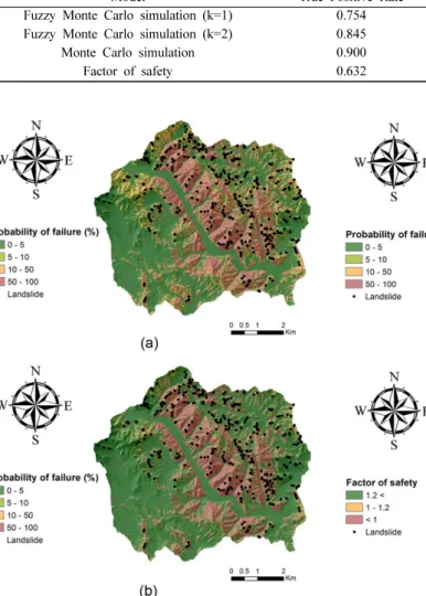
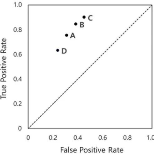
(7) Fuzzy Monte Carlo simulation을 이용한 물리 사면 모델 기반의 상주지역 산사태 취약성 분석. 245. 업에서 50 cm 해상도로 촬영된 항공사진 분석과 현장 조사를 통해 총 418개소의 산사태 발생위치를 획득하 였고, 그 위치를 기반으로 산사태 현황도(inventory map, Fig. 4)를 구축하였다.. 6. 분석 및 결과 본 연구에서는 1998년 8월 약 280 mm의 집중호우 로 인하여 다수의 산사태가 발생한 상주 지역에 대해 본 연구에서 제안한 퍼지몬테카를로기법(Fuzzy Monte Carlo simulation)을 활용하여 취약성 분석을 수행하였 다. 특히 본 연구에서는 강우의 영향을 고려하기 위해 SHALSTAB을 활용하여 지하수위를 산정하였으며 이 렇게 산정된 지하수위를 분석에 활용하였다. 또한 제 안된 분석기법의 정확도를 비교하기 위하여 기존의 확 률론적 기법인 몬테카를로기법(Monte Carlo simulation) 을 활용하여 취약성 분석을 수행하였으며 불확실성을 고려하지 않은 결정론적 해석 방법도 이용하여 분석을 수행하고 그 결과를 비교하였다. 먼저 본 연구에서 제안한 퍼지몬테카를로기법(Fuzzy Monte Carlo simulation)을 활용한 취약성 분석을 위 하여 확률변수로 고려되는 입력 변수인 점착력과 마찰 각의 평균값과 변동계수(Coefficient Of Variation, COV)를 산정하였다. 그리고 확률변수의 퍼지숫자를 산 정하기 위하여 퍼지숫자의 k 값을 1과 2로 적용하였으 며 20,000번의 반복 계산을 통해 퍼지숫자를 산정하고 이를 물리 사면 모델에 대입하여 반복적인 계산을 수 행하였다. 한편 비교를 위하여 수행되는 몬테카를로기 법(Monte Carlo simulation)에서는 선행연구(Mostyn and Li, 1993; Nilsen, 2000; Pathak and Nilsen, 2004; Park et al., 2005; Park, 2007; Lee, 2013)를 참고하여 점착력과 마찰각의 확률분포를 정규분포 (normal distribution)로 가정하였으며 퍼지몬테카를로 기법(Fuzzy Monte Carlo simulation)과 동일한 변동 계수(COV)와 반복횟수를 이용하여 분석을 수행하였다. 또한 결정론적 해석에서는 불확실성을 고려하지 않고 입력변수의 평균값만으로 계산을 수행하였다. 본 연구에서는 취약성 분석결과의 정확도를 판단하기 위해 ROC (Receiver Operating Characteristics) 그래 프를 활용하였다(Egan, 1975; Swets, 1988; Williams et al., 1999; Gorsevski et al., 2006; Lee, 2013). ROC 그래프는 취약성 분석 결과와 산사태 발생 위치 를 비교하여 분석 결과의 정확성을 검증하는 방법으로 혼동 행렬(confusion matrix)을 계산하여 검증에 활용. Fig. 8. Confusion matrix.. 한다. 혼동 행렬(confusion matrix)은 산사태 발생유무 와 분석모델의 예측 결과 사이의 관계를 TP (True Positive), FP (False Positive), FN (False Negative), TN (True Negative)으로 나타낸 것이다(Fig. 8). 혼동 행렬(confusion matrix)에서 TP는 분석 결과 산사태 발생을 예측하였고 실제도 발생한 경우, FP는 산사태 발생을 예측하였지만 실제로 발생하지 않은 경우, FN 은 안전한 지역으로 예측하였지만 실제로 산사태가 발 생한 경우, TN은 안전한 지역으로 예측하였고 실제로 도 안전한 지역인 경우를 나타낸다. 혼동 행렬 (confusion matrix)로부터 실제로 산사태가 발생한 지 역 내에서의 예측 정확성을 나타내는 TPR (True Positive Rate)과 산사태가 발생하지 않은 지역에서의 예측 오류율을 의미하는 FPR (False Positive Rate) 을 산정하고, 이를 ROC 그래프 상에 나타낸다. 이때 ROC 그래프에 표시된 해석 결과의 위치가 ROC 그래 프 왼쪽 상단(0,1)에 가까울수록 예측 정확성이 높고 성능(performance)이 좋은 모델이라고 할 수 있으며, 그래프 결과의 하단부 면적을 계산하여 AUC (Area Under Curve)를 획득한다. AUC 값의 크기는 예측의 정확성을 나타내며 AUC 값이 클수록 좀 더 정확한 모델임을 의미한다(Fawcett, 2006; Gorsevski et al., 2006; Godt et al., 2008; Lee, 2013). 본 연구에서 분석 기법의 예측 정확도를 판단하기 위하여 TPR과 FPR, AUC를 사용하였다. 퍼지몬테카 를로기법(Fuzzy Monte Carlo simulation) 수행 결과 는 k=1일 때, 불안정한 지역은 31.1%이고 안정한 지 역은 69.0%이고 TPR은 0.754, FPR은 0.310, AUC 값은 0.722이다(Table 2, Fig. 9a). 또한 k=2일 때는 불안정한 지역은 38.6%, 안정한 지역은 61.4%이며 TPR은 0.845, FPR은 0.386, AUC 값은 0.723이었다 (Table 2, Fig. 9b). 또한 퍼지몬테카를로기법(Fuzzy Monte Carlo simulation)과 비교를 위해 수행된 몬테.
(8) 246. 장정윤 · 박혁진. Table 1. Characteristics of input parameters in the study area. Probabilistic factor Deterministic factor. Geomechanical parameter Cohesion [t/m²] Friction angle [degree] Hydraulic conductivity [m/h] Unit weight [t/m³]. Mean value 0.61 35.39 0.097 1.34. standard deviation value 0.13 1.21 -. Table 2. Comparison of model performance for Fuzzy Monte Carlo simulation (k=1,2), Monte Carlo simulation and deterministic method Model Fuzzy Monte Carlo simulation (k=1) Fuzzy Monte Carlo simulation (k=2) Monte Carlo simulation Factor of safety. True Positive Rate 0.754 0.845 0.900 0.632. Fig. 9. Maps showing probability of failure evaluated using Fuzzy Monte Carlo simulation (a) k=1, (b) k=2.. 카를로기법(Monte Carlo simulation)의 결과에서 안정 한 지역은 전체 영역의 54.6% 불안정한 지역은 45.4%를 보였고 TPR과 FPR은 각각 0.900, 0.453, AUC는 0.723 값을 보였다(Table 2, Fig. 10a). 또한 안전율 수행 결과는 안정한 지역은 전체 영역의. False Positive Rate 0.310 0.386 0.453 0.239. AUC 0.722 0.729 0.723 0.696. Fig. 10. Maps showing probability of failure evaluated using (a) Monte Carlo simulation, (b) factor of safety using the deterministic analysis.. 76.1%이고 불안정한 지역은 20.9%를 보였고 TPR과 FPR은 각각 0.632, 0.239, AUC는 0.696 값을 보였다 (Table 2, Fig. 10b). 따라서 퍼지몬테카를로기법(Fuzzy Monte Carlo simulation)을 활용한 분석의 경우(0.722,.
(9) Fuzzy Monte Carlo simulation을 이용한 물리 사면 모델 기반의 상주지역 산사태 취약성 분석. 247. 실성을 정량화하기 위하여 확률론적 기법이 활용되어 왔지만, 광역적인 지역을 대상으로 하는 산사태 취약 성 분석에서는 충분한 자료를 획득하기 어렵기 때문에 발생하는 불확실성을 정량화하는데 어려움이 발생한다. 즉, 확률특성을 정의하기에 충분한 양의 수량의 자료 가 요구되는 확률론적 기법은 자료의 부족으로 인해 발생하는 불확실성을 정량화하기 어렵다. 따라서 본 연. Fig. 11. ROC graph comparing the analysis results A : Fuzzy Monte Carlo simulation (k=1), B : Fuzzy Monte Carlo simulation (k=2), C : Monte Carlo simulation, D : deterministic analysis.. 0.729)와 몬테카를로기법(Monte Carlo simulation)을 활용한 확률론적 해석기법의 경우(0.723) 결정론적 해 석 결과(0.696)보다 높은 값을 보여 우수한 성능을 보 이는 것으로 나타났다. 한편 Formetta et al.(2016)의 연구에 따르면 0.7보다 큰 TPR과 0.4미만의 FPR을 갖 는 모델은 성능(performance)이 최적화된(optimization) 모델이라고 할 수 있다. 퍼지몬테카를로기법(Fuzzy Monte Carlo simulation)은 k가 1과 2일 때 TPR이 각각 0.754, 0.845, FPR이 0.310, 0.386을 보이고 있 으나 몬테카를로기법(Monte Carlo simulation)의 경우 TPR이 0.900, FPR이 0.453을 보이고 있어 퍼지몬테 카를로기법(Fuzzy Monte Carlo simulation)의 성능이 확률론적 해석기법인 몬테카를로기법(Monte Carlo simulation)을 활용한 해석기법보다 우수한 것으로 판 단된다.. 7. 결. 론. 물리 모델 기반의 산사태 취약성 분석기법은 연구 지역 사면의 기하학적 특성과 사면 물질의 공학적 특 성을 고려하여 사면의 안정성을 분석하는 방법이다. 이 분석기법은 산사태의 발생 메커니즘을 고려할 수 있기 때문에 최근 들어 활발히 활발히 사용되고 있다. 그러 나 물리 모델 기반의 분석에서 사용되는 입력 자료들 중 지질공학적 인자들은은 자료의 부족이나 사면물질 의 공간적 변동성과 복잡한 지질조건으로 인해 분석 과정에서 불확실성이 개입된다. 최근까지 이러한 불확. 구에서는 이러한 불확실성을 효과적으로 고려하기 위 하여 퍼지집합이론을 사용하였다. 불확실성이 내재된 인자를 퍼지숫자로 고려하고 확률론적 기법인 몬테카 를로기법(Monte Carlo simulation)을 수행하는 퍼지몬 테카를로기법(Fuzzy Monte Carlo simulation)을 제안 하였다. 그리고 분석 기법의 적용성을 평가하기 위하 여 상주 지역 일대를 대상으로 퍼지몬테카를로기법 (Fuzzy Monte Carlo simulation)을 수행하였고, 정확 도 검증을 위해 기존의 확률론적 기법인 몬테카를로기 법(Monte Carlo simulation)과 단순 평균값으로 안전 율을 산정하는 결정론적 기법의 수행 결과와 비교하였 다. 또한 연구지역의 지반 수리특성과 강우강도를 고 려하는 SHALSTAB을 활용하여 지하수위를 산정하였 고 분석에 적용하였다. 퍼지몬테카를로기법(Fuzzy Monte Carlo simulation) 은 자료의 부족으로 발생하는 불확실성을 고려할 수 있을 뿐만 아니라 지질공학적 변수의 누적확률분포함 수 대신 퍼지숫자로 고려하기 때문에 연구지역의 지질 공학적 변수의 특성 따라 k 값을 조정할 수 있고, 각 변수의 k 값을 조정하여 유연성 있게 변수에 대한 불 확실성을 통제할 수 있다. 연구지역을 대상으로 제안된 분석기법과 결정론적 해석기법 그리고 확률론적 해석 기법을 적용하여 분석기법의 정확도를 분석한 결과 퍼지 몬테카를로기법(Fuzzy Monte Carlo simulation)과 확률 론적 기법인 몬테카를로기법(Monte Carlo simulation) 이 모두 결정론적 해석 결과에 비해 높은 정확도를 보 이는 것으로 나타났다. 특히 퍼지몬테카를로기법(Fuzzy Monte Carlo simulation)은 TPR 값이 0.7이상, FPR 값이 0.4이하의 값을 보여 기존의 몬테카를로기법 (Monte Carlo simulation)에 비해 좀 더 최적화된 모 델 성능을 보이는 것으로 나타났다.. 사. 사. 본 연구는 2016년도 한국연구재단-중견연구자지원사 업(NRF-2016R1A2B4008963)의 지원을 받아 수행된 연구입니다..
(10) 248. 장정윤 · 박혁진. References Avanzi, G.D.A., Falaschi, F., Giannecchini, R. and Puccinelli, A. (2009) Soil slip susceptibility assessment using mechanical–hydrological approach and GIS techniques: an application in the Apuan Alps (Italy). Natural hazards, v.50, p.591-603. Takara, K., Yamashiki, Y., Sassa, K., Ibrahim, A.B. and Fukuoka, H. (2010) A distributed hydrological–geotechnical model using satellite-derived rainfall estimates for shallow landslide prediction system at a catchment scale. Landslides, v.7, p.237-258. Beven, K.J. and Kirkby, M.J. (1979) A physically based, variable contributing area model of basin hydrology/ Un modèle à base physique de zone d'appel variable de l'hydrologie du bassin versant. Hydrological Sciences Journal, v.24, p.43-69. Borga, M., Dalla Fontana, G., Da Ros, D. and Marchi, L. (1998) Shallow landslide hazard assessment using a physically based model and digital elevation data. Environmental geology, v.35, p.81-88. Burrough, P.A., MacMillan, R.A. and Deursen, W.V. (1992) Fuzzy classification methods for determining land suitability from soil profile observations and topography. European Journal of Soil Science, v.43, p.193-210. Burton, A. and Bathurst, J.C. (1998) Physically based modelling of shallow landslide sediment yield at a catchment scale. Environmental Geology, v.35, p.89-99. Chae, B.G., Lee, J.H., Park, H.J. and Choi, J. (2015) A method for predicting the factor of safety of an infinite slope based on the depth ratio of the wetting front induced by rainfall infiltration. Natural Hazards and Earth System Sciences, v.15, p.1835-1849. Chen, C.S. and Liu, Y.C. (2007) A methodology for evaluation and classification of rock mass quality on tunnel engineering. Tunnelling and Underground Space Technology, v.22, p.377-387. Choi, J.G. (2007) Geostatistics. Sigmapress, 386p. Coduto, D.P., Yeung, M.R. and Kitch, W.A. (2010) Geotechnical engineering: principles and practices. 2nd edition, Pearson, 816p. Davis, T.J. and Keller, C.P. (1997) Modelling uncertainty in natural resource analysis using fuzzy sets and Monte Carlo simulation: slope stability prediction. International Journal of Geographical Information Science, v.11, p.409-434. Dietrich, W.E., Wilson, C.J., Montgomery, D.R., McKean, J. and Bauer, R. (1992) Erosion thresholds and land surface morphology. Geology, v.20, p.675-679. Dodagoudar, G.R. and Venkatachalam, G. (2000) Reliability analysis of slopes using fuzzy sets theory, Computers and Geotechnics, v.27, p.101-115. Egan, J.P. (1975) Signal detection theory and ROC analysis. Academic Press, 297p. Einstein, H.H. and Baecher, G.B. (1982) Probabilistic and statistical methods in engineering geology I. Problem statement and introduction to solution. In Ingenieurgeologie und Geomechanik als Grundlagen des Felsbaues / Engineering Geology and Geomechanics as Fundamentals of Rock Engineering, p.47-61.. El-Ramly, H., Morgenstern, N.R. and Cruden, D. M. (2002) Probabilistic slope stability analysis for practice. Canadian Geotechnical Journal, v.39, p.665-683. Elton, D. J., Juang, C. H. and Lin, P. S. (2000) Vertical capacity of piles using fuzzy sets. CIVIL ENGINEERING SYSTEMS, v.17, p.237-262. Fawcett, T. (2006) An introduction to ROC analysis. Pattern recognition letters, v.27, p.861-874. Fell, R., Corominas, J., Bonnard, C., Cascini, L., Leroi, E. and Savage, W. Z. (2008) Guidelines for landslide susceptibility, hazard and risk zoning for land-use planning. Engineering Geology, v.102, p.99-111. Finol, J., Guo, Y.K. and Jing, X.D. (2001) A rule based fuzzy model for the prediction of petrophysical rock parameters. Journal of Petroleum Science and Engineering, v.29, p.97-113. Formetta, G., Capparelli, G. and Versace, P. (2016) Evaluating performance of simplified physically based models for shallow landslide susceptibility. Hydrology and Earth System Sciences, v.20, p.4585. Frattini, P., Crosta, G.B., Fusi, N. and Dal Negro, P. (2004) Shallow landslides in pyroclastic soils: a distributed modelling approach for hazard assessment, Engineering Geology, v.73, p.277-295. Ghose, A.K. and Dutta, D. (1987) A rock mass classification model for caving roofs. International Journal of Mining and Geological Engineering, v.5, p.257-271. Giasi, C.I., Masi, P. and Cherubini, C. (2003) Probabilistic and fuzzy reliability analysis of a sample slope near Aliano. Engineering Geology, v.67, p.391-402. Godt, J.W., Baum, R.L., Savage, W.Z., Salciarini, D., Schulz, W.H. and Harp, E.L. (2008) Transient deterministic shallow landslide modeling: requirements for susceptibility and hazard assessments in a GIS framework. Engineering Geology, v.102, p.214-226. Gokceoglu, C. (2002) A fuzzy triangular chart to predict the uniaxial compressive strength of the Ankara agglomerates from their petrographic composition. Engineering Geology, v.66, p.39-51. Gokceoglu, C. and Zorlu, K. (2004) A fuzzy model to predict the uniaxial compressive strength and the modulus of elasticity of a problematic rock. Engineering Applications of Artificial Intelligence, v.17, p.61-72. Gorsevski, P.V., Gessler, P.E., Foltz, R.B. and Elliot, W.J. (2006) Spatial prediction of landslide hazard using logistic regression and ROC analysis. Transactions in GIS, v.10, p.395-415. Griffiths, D.V., Huang, J. and Fenton, G.A. (2011) Probabilistic infinite slope analysis. Computers and Geotechnics, v.38, p.577-584. Grima, M.A. and Babuška, R. (1999) Fuzzy model for the prediction of unconfined compressive strength of rock samples. International Journal of Rock Mechanics and Mining Sciences, v.36, p.339-349. Haldar, A. and Mahadevan, S. (2000) Reliability assessment using stochastic finite element analysis. John Wiley & Sons, 344p. Hamidi, J.K., Shahriar, K., Rezai, B. and Bejari, H. (2010) Application of fuzzy set theory to rock engineering classification systems: an illustration of the rock mass excavability index. Rock mechanics and rock engineering, v.43, p.335-350..
(11) Fuzzy Monte Carlo simulation을 이용한 물리 사면 모델 기반의 상주지역 산사태 취약성 분석 Hanss, M. and Turrin, S. (2010) A fuzzy-based approach to comprehensive modeling and analysis of systems with epistemic uncertainties. Structural Safety, v.32, p.433-441. Harr, M.E. (1987) Reliability based on Design in Civil Engineering. Mcgraw-Hill, 400p. Ho, J.Y., Lee, K.T., Chang, T.C., Wang, Z.Y. and Liao, Y.H. (2012) Influences of spatial distribution of soil thickness on shallow landslide prediction. Engineering Geology, v.124, p.38-46. Horton, R.E. (1933) The role of infiltration in the hydrologic cycle. Eos, Transactions American Geophysical Union, v.14, p.446-460. Huang, J.C., Kao, S.J., Hsu, M.L. and Lin, J.C. (2006) Stochastic procedure to extract and to integrate landslide susceptibility maps: an example of mountainous watershed in Taiwan. Natural Hazards and Earth System Science, v.6, p.803-815. Huang, J.C., Kao, S.J., Hsu, M.L. and Liu, Y.A. (2007) Influence of Specific Contributing Area algorithms on slope failure prediction in landslide modeling. Natural Hazards and Earth System Sciences, v.7, p.781-792. Jang, H.D. and Yang, H.S. (2010) An analysis of stability on rock slope by changing water level, Tunnel and Underground Space, v.20(1), p.7-14. Jang, W.S., Ryu, J.C., Kang, H.W., Kim, K.S., Lee, C., Kim, Y.S. and Lim, K.J. (2010) Application of the Technique for Determining the Most Appropriate Spot for a Check-dam in Chungju-dam Watershed. Journal of the Environment, v.7, p.19-31. Juang, C.H. and Elton, D.J. (1996) A practical approach to uncertainty modeling in geotechnical engineering. In Uncertainty in the Geologic Environment: from Theory to Practice, ASCE, p.1269-1283. Juang, C.H., Wey, J.L. and Elton, D.J. (1991) Model for capacity of single piles in sand using fuzzy sets. Journal of Geotechnical Engineering, v.117, p.1920-1931. Juang, C.H., Huang, X.H. and Elton, D.J. (1992a) Modelling and analysis of non-random uncertainties— fuzzy-set approach. International journal for numerical and analytical methods in geomechanics, v.16, p.335-350. Juang, C.H., Lee, D.H. and Sheu, C. (1992b) Mapping slope failure potential using fuzzy sets. Journal of geotechnical engineering, v.118, p.475-494. Juang, C.H., Jhi, Y.Y. and Lee, D.H. (1998) Stability analysis of existing slopes considering uncertainty. Engineering Geology, v.49, p.111-122. Kamai, T. (1991) Slope stability assessment by using GIS. Science and Technology Agency of Japan, in Japanese. Kayabasi, A., Gokceoglu, C. and Ercanoglu, M. (2003) Estimating the deformation modulus of rock masses: a comparative study. International Journal of Rock Mechanics and Mining Sciences, v.40, p.55-63. Kim, J.S., Kim. N.C. and Lee, H.H. (2000) Articles : Application of a Physically Based Model to Shallow landsliding. The Korea Society For Environmental Restoration And Revegetation Technology, v.3, p.62-69. Kim, J.S. (2011) Assessment of Landslide Hazard Induced by Earthquake and Groundwater Level Variation. Masters dissertation, Sejong university, Seoul.. 249. Kim, W.Y., Chae B.G., Kim, K.S., Cho, Y.C., Lee, C.O., Lee, C.W., Kim, K.Y., Kim, J.H. and Kim, J.M. (2003) Study on landslide hazard prediction. Ministry of Science and Technology, 339p. Kim, K.S., Song, Y.S., Cho, Y.C., Kim, W.Y. and Jeong, G.C. (2006) Characteristics of Rainfall and Landslides according to the Geological Condition. The journal of Engineering geology, v.16, p.201-214. Kim, M.S., Kim, J.K., Cho, Y.C. and Kim, S.W. (2011) Geomorphic-characteristics of debris flow induced by typhoon "RUSA" in 2002 using Shalstab Model and Remote Sensing: case study in Macheon region near Jiri-Mountain. Journal of the Korean geomorphological association, v.18, p.193-202. Lee, J.H. (2013) Landslide susceptibility analysis using transient infiltration model and probabilistic method in Inje area. Masters dissertation, Sejong university, Seoul. Lee, J.H. and Park, H.J. (2012) Assessment of landslide susceptibility using a coupled infinite slope model and hydrologic model in Jinbu area, Gangwon-do. Economic and Environmental Geology, v.45, p.697-707. Lee, J.H. and Park, H.J. (2016) Assessment of shallow landslide susceptibility using the transient infiltration flow model and GIS-based probabilistic approach. Landslides, v.13, p.885-903. Lee, S.H. (2005) Application of a physically based hydrologic model to the prediction of shallow landslide potential area using GIS. Doctor dissertation, Chungbuk university, Cheongju-si, Chungcheongbuk-do. Lee, H.W. (2011) Analysis of Landslide Susceptibility using Probabilistic Method and GIS. Masters dissertation, Sejong university, Seoul. Luo, Z., Atamturktur, S., Juang, C.H., Huang, H. and Lin, P.S. (2011) Probability of serviceability failure in a braced excavation in a spatially random field: Fuzzy finite element approach. Computers and Geotechnics, v.38, p.1031-1040. McBratney, A.B. and Moore, A.W. (1985) Application of fuzzy sets to climatic classification. Agricultural and forest meteorology, v.35, p.165-185. Michel, G.P., Kobiyama, M. and Goerl, R.F. (2014) Comparative analysis of SHALSTAB and SINMAP for landslide susceptibility mapping in the Cunha River basin, southern Brazil. Journal of soils and sediments, v.14, p.1266-1277. Montgomery, D.R. and Dietrich, W.E. (1994) A physically based model for the topographic control on shallow landsliding. Water resources research, v.30, p.11531171. Mostyn, G.R. and Li, K.S. (1993) Probabilistic slope analysis — state of play. In Proceedings, Conference on Probabilistic Methods in Geotechnical Engineering, p.89-109. Mostyn, G.R. and Small, J.C. (1987) Methods of stability analysis. Soil Slope Instability and Stabilization, Balkema, p.71-120. National Disaster Management Institute (2000) Fundamental Issues for Landslide Hazards Avoidance or Mitigation Plans. National Disaster Management Institute, 276p. Nilsen, B. (2000) New trends in rock slope stability anal-.
(12) 250. 장정윤 · 박혁진. yses. Bulletin of Engineering Geology and the Environment, v.58, p.173-178. O'loughlin, E.M. (1986) Prediction of surface saturation zones in natural catchments by topographic analysis. Water Resources Research, v.22, p.794-804. Pack, R.T., Tarboton, D.G. and Goodwin, C.N. (1998) The SINMAP approach to terrain stability mapping. In 8th congress of the international association of engineering geology, Vancouver, British Columbia, Canada, p.1157-1165. Park, H.J. (2007) The Evaluation of Failure Probability for Rock Slope Based on Fuzzy Set Theory and Monte Carlo Simulation. Journal of the Korean Geotechnical Society, v.23, p.109-117. Park, H.J. and West, T.R. (2001) Development of a probabilistic approach for rock wedge failure. Engineering Geology, v.59, p.233-251. Park, H.J., Lee, J.H. and Woo, I. (2013) Assessment of rainfall-induced shallow landslide susceptibility using a GIS-based probabilistic approach. Engineering Geology, v.161, p.1-15. Park, H.J., Lee, S.R. and Kim, J.W. (2003) Analysis and Verification of Slope Disaster Hazard Using Infinite Slope Model and GIS. Economic and environmental geology, v.36, p.313-320. Park, H.J., Um, J.G. and Woo, I. (2008) The evaluation of failure probability for rock slope based on fuzzy set theory and Monte Carlo simulation. In Proceedings of the 10th international symposium on landslides and engineered slopes, p.1943-1949. Park, H.J., Um, J.G., Woo, I. and Kim, J.W. (2012) Application of fuzzy set theory to evaluate the probability of failure in rock slopes. Engineering Geology, v.125, p.92-101. Park, H.J., West, T.R. and Woo, I. (2005) Probabilistic analysis of rock slope stability and random properties of discontinuity parameters, Interstate Highway 40, Western North Carolina, USA. Engineering Geology, v.79, p.230-250. Pathak, S. and Nilsen, B. (2004) Probabilistic rock slope stability analysis for Himalayan conditions. Bulletin of Engineering Geology and the Environment, v.63, p.25-32. Pradhan, A.M.S. and Kim, Y.T. (2015) Application and comparison of shallow landslide susceptibility models in weathered granite soil under extreme rainfall events. Environmental Earth Sciences, v.73, p.57615771. Pradhan, A.M.S. and Kim, Y.T. (2016) Evaluation of a combined spatial multi-criteria evaluation model and deterministic model for landslide susceptibility mapping. Catena, v.140, p.125-139. Rosso, R., Rulli, M.C. and Vannucchi, G. (2006) A physically based model for the hydrologic control on shallow landsliding. Water Resources Research, v.42, p.W06410. Sadeghi, N., Fayek, A.R. and Pedrycz, W. (2010) Fuzzy Monte Carlo simulation and risk assessment in construction. Computer-Aided Civil and Infrastructure Engineering, v.25, p.238-252. Santoso, A.M., Phoon, K.K. and Quek, S.T. (2011) Effects. of soil spatial variability on rainfall-induced landslides. Computers & Structures, v.89, p.893-900. Saulnier, G.M., Beven, K. and Obled, C. (1997) Including spatially variable effective soil depths in TOPMODEL. Journal of hydrology, v.202, p.158-172. Song, Y.S. and Hong, W.P. (2011) Analysis of slope stability with consideration of the wetting front and groundwater level during rainfall. The Journal of Engineering Geology, v.21, p.25-34. Swets, J.A. (1988) Measuring the accuracy of diagnostic systems. Science, v.240, p.1285. Terlien, M.T.J. (1996) Modelling spatial and temporal variations in rainfall-triggered landslides: the integration of hydrologic models, slope stability models and geographic information systems for the hazard zonation of rainfall-triggered landslides with examples from Manizales (Colombia). International Institute for Aerial Survey and Earth Sciences , ITC, 254p. venkatachalam, G. (2006) Reliability and Risk analysis of slopes. indian geotechnical journal, v.35. p.1-67. Westen, C.V. and Terlien, M.J.T. (1996) An approach towards deterministic landslide hazard analysis in GIS. A case study from Manizales (Colombia), Earth Surface Processes and Landforms, v.21, p.853-868. Whittle, A.J. and Hashash, Y.M.A. (1994) Soil modeling and prediction of deep excavation behavior. Pre-failure deformation of geomaterials: Rotterdam, AA Balkema, p.589-594. Williams, C.J., Lee, S.S., Fisher, R.A. and Dickerman, L.H. (1999) A comparison of statistical methods for prenatal screening for Down syndrome. Applied Stochastic Models in Business and Industry, v.15, p.89-101. Witt, A.C. (2005) Using a GIS (Geographic Information System) to model slope instability and debris flow hazards in the French Broad River watershed. The degree of Master of Science, North Carolina State University, North Carolina. Wu, W. and Sidle, R.C. (1995) A distributed slope stability model for steep forested basins. Water resources research, v.31, p.2097-2110. Xie, M., Esaki, T. and Zhou, G. (2004) GIS-based probabilistic mapping of landslide hazard using a threedimensional deterministic model. Natural Hazards, v.33, p.265-282. Xu, C., Wang, L., Tien, Y.M., Chen, J.M. and Juang, C.H. (2014) Robust design of rock slopes with multiple failure modes: modeling uncertainty of estimated parameter statistics with fuzzy number. Environmental earth sciences, v.72, p.2957-2969. Yao, Y., Li, X. and Yuan, Z. (1999) Tool wear detection with fuzzy classification and wavelet fuzzy neural network. International Journal of Machine Tools and Manufacture, v.39, p.1525-1538. Zadeh, L.A. (1965) Fuzzy sets. Information and control, v.8, p.338-353. Zhou, G., Esaki, T., Mitani, Y., Xie, M. and Mori, J. (2003) Spatial probabilistic modeling of slope failure using an integrated GIS Monte Carlo simulation approach. Engineering Geology, v.68, p.373-386. Zimmermann, H.J. (1991) Fuzzy Set Theory and Its Applications. 2nd edition, Springer, 399p..
(13)
수치


+2
관련 문서
[r]
그림에서 왼쪽은 현재의 상태를 표현한 것으로 물 -에너지-식량 연관관계가 명확하게 분석되지 않아 (Unknown and unbalanced) 가용 수자원으로부터 생산을 위한 물로
여러 종류의 식당을 , 일반식당, 패밀리레스토랑, 고급식당, 계약급식업체로 나누어 보면 일반식당에서는 고객이 남기고 간 음식물쓰레기
실내 인테리어를 중앙아시아 전통 양식으로 꾸며놨기 때문에 이국적인 분위기 속에서 중앙아시아 음 식을 맛볼 수 있다.. 뿌르뿌 르와 함께 비쉬켁의 조지아
First, we can approximate mismatch-induced offsets as low-frequency AC noise and hence substitute time- consuming Monte-Carlo simulations with small-signal noise consuming
[r]
[r]
Drineas et al., Fast Monte Carlo Algorithms for Matrices III: Com puting a Compressed Approximate Matrix Decomposition, SIAM Journal on Computing,
