Journal of the Korean Society of Surveying, Geodesy, Photogrammetry and Cartography Vol. 33, No. 4, 267-275, 2015
http://dx.doi.org/10.7848/ksgpc.2015.33.4.267
국가토지피복도와 무감독분류를 이용한 초기 훈련자료 자동추출과 토지피복지도 갱신
Automatic Extraction of Initial Training Data Using National Land Cover Map and Unsupervised Classification and Updating Land Cover Map
이승기1) · 최석근2) · 노신택3) · 임노열4) · 최주원5)
Lee, Soungki · Choi, Seok Keun · Noh, Sintaek · Lim, Noyeol · Choi, Juweon
Abstract
Those land cover maps have widely been used in various fields, such as environmental studies, military strategies as well as in decision-makings. This study proposes a method to extract training data, automatically and classify the cover using ingle satellite images and national land cover maps, provided by the Ministry of Environment. For this purpose, as the initial training data, those three were used; the unsupervised classification, the ISODATA, and the existing land cover maps. The class was classified and named automatically using the class information in the existing land cover maps to overcome the difficulty in selecting classification by each class and in naming class by the unsupervised classification; so as achieve difficulty in selecting the training data in supervised classification.
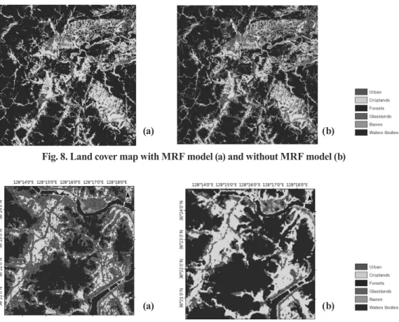
The extracted initial training data were utilized as the training data of MLC for the land cover classification of target satellite images, which increase the accuracy of unsupervised classification. Finally, the land cover maps could be extracted from updated training data that has been applied by an iterative method. Also, in order to reduce salt and pepper occurring in the pixel classification method, the MRF was applied in each repeated phase to enhance the accuracy of classification. It was verified quantitatively and visually that the proposed method could effectively generate the land cover maps.
Keywords : Land Cover Map, Training Data, MRF, Medium-resolution Satellite Image
초 록
토지피복지도는 환경, 군사, 의사결정 등 다양한 분야에서 널리 사용되고 있다. 본 연구에서는 단일 위성영상과
환경부에서 제공하는 국가토지피복도를 이용하여 훈련자료를 자동으로 추출하고, 이를 활용하여 피복을 분류하
는 방법을 제안하였다. 이를 위하여 초기 훈련자료는 무감독분류인 ISODATA와 기존 토지피복도를 이용하였으며,
무감독 분류 사용시 각 클래스별 분류 선정과 클래스 명명, 감독분류에서 훈련자료 선정 등의 문제점을 해결하기
위하여 기존 토지피복도의 클래스 정보를 활용하여 자동으로 클래스를 분류하고 명명하였다. 추출된 초기 훈련자
료는 대상 위성영상의 토지피복분류를 위하여 MLC의 훈련자료를 활용하였고, 피복분류의 정확도 향상을 위하여
반복방법을 적용하여 훈련자료를 갱신하였으며 최종적으로 토지피복지도를 추출하였다. 또한, 화소분류방법에서
발생하는 salt and pepper를 감소시키기 위하여 각 반복단계별 MRF를 적용하여 분류정확도를 향상시켰다. 본 연
구에서 제안된 방법을 대상지역에 적용한 결과 효과적으로 토지피복지도를 생성할 수 있음을 정량적, 시각적으로
확인하였다.
핵심어 : 토지피복도, 훈련자료, MRF, 중해상도 위성영상
267 ISSN 1598-4850(Print) ISSN 2288-260X(Online) Original article
Received 2015. 06. 25, Revised 2015. 07. 22, Accepted 2015. 08. 21
1) Member, Department of Civil Engineering, Chungbuk University(E-mail:[email protected])
2) Corresponding Author, Member, Department of Civil Engineering, Chungbuk University(E-mail:[email protected]) 3) Member, Department of Civil Engineering, Chungbuk University(E-mail:[email protected])
4) Department of Civil Engineering, Chungbuk University(E-mail:[email protected]) 5) Department of Civil Engineering, Chungbuk University(E-mail:[email protected])
This is an Open Access article distributed under the terms of the Creative Commons Attribution Non-Commercial License (http://
creativecommons.org/licenses/by-nc/3.0) which permits unrestricted non-commercial use, distribution, and reproduction in any medium, provided the original work is properly cited.
Journal of the Korean Society of Surveying, Geodesy, Photogrammetry and Cartography, Vol. 33, No. 4, 267-275, 2015
268
1. 서 론
위성영상은 소규모 지역에서부터 범지구적인 범위까지 지 표면의 상태를 파악하는데 이용되고 있으나, 기존의 제공되 는 데이터가 실제 지표면과 차이가 많이 발생하며, 도시계획 과 같이 지역적인 범위의 데이터가 필요한 경우 충분한 데이 터를 제공하지 못하는 것으로 나타났다(Hansen and Reed, 2000; Kaptué Tchuenté et al., 2011).
따라서, 이와 같은 문제점을 해결하고자 중해상도 영상 과 고해상도 영상을 이용한 토지피복분류를 시도하고 있으 나, 훈련자료 생성에 많은 인력과 시간이 드는 단점이 나타났 다(Chen et al., 2012). 선행연구에서는 무감독분류를 수행하 거나(Lu et al., 2004), 보조자료를 이용하여 훈련자료를 추 출하였고(Kim et al., 2010; Chen et al.,2012), 특히, Chen et al.(2012)의 연구에서는 두 개의 다른 시기의 Landsat 영상과 기존의 토지피복지도를 이용하여 초기 훈련자료를 추출한 후 변화지역을 추출하였다.
국내에서는 Kim et al.(2010)는 고해상도 위성인 SPOT-5 와 QuickBird 위성영상과 Landsat 영상을 활용하여 접근 이 불가능한 지역의 훈련자료를 자동 생성하였으며, Choi et al.(2014a)는 단일 Landsat영상과 기존토지피복도를 이용하 여 훈련자료를 생성하였다.
특히, 기존의 제작된 주제지도를 이용방법은 대상지역에 대 한 2개 이상의 영상을 얻기 힘들거나, 대상지역의 사전 정보 를 얻을 수 없는 경우, 또는 정확도 향상 등을 위하여 적용할 수 있으나(Jensen et al., 2009; Chen et al., 2012; Zhang et al., 2014), 현재 제안된 방법들은 2개 이상의 영상이 필요한(고해 상도 위성영상 포함)것이 대부분을 차지하고 있어 2개 이상 의 영상취득이 어려운 경우 적용에 한계점을 나타내고 있다.
국내에서 제안된 방법은 고해상도 위성영상을 취득하기 어 려운 경우 적용하기가 힘들며, 단일 위성영상을 이용한 방법 또한 화소기반으로 일부 지역에서 salt and pepper가 발생하 는 것을 확인할 수가 있었다.
따라서, 본 연구에서는 기존의 토지피복도와 단일 위성영 상만을 이용하여 무감독분류를 수행하고 클래스를 자동으 로 인식하여 초기 훈련자료를 추출하였다. 추출된 훈련자료 를 MLC의 초기 훈련자료로 적용하여 재분류하고 이전 훈련 자료와 비교를 통하여 새로운 훈련자료를 생성하였다. 각 반 복단계별 MRF를 적용하여 화소기반에서 발생할 수 있는 노 이즈를 감소시키고, 정해진 임계치를 만족할 때 까지 반복과 정을 수행하였다. 결과적으로, 자동으로 추출된 훈련자료를 활용하여 토지피복지도를 분류하고 반복과정을 거쳐 정확도
를 향상시키고자 하였다.
2. 연구방법
본 연구는 위성영상의 대기보정을 위한 전처리 과정, 초기 훈련자료의 구축, 반복 분류를 통한 최종 훈련자료 추출 등으 로 구분되며, 연구 흐름도는 Fig. 1과 같다. 먼저, Landsat 자료 와 토지피복도를 활용하여 자동으로 초기 훈련자료를 추출하 였고, 이를 기반으로 피복분류를 반복적으로 적용하여 훈련 자료를 재설정하고 토지피복지도를 갱신하였다.
2.1 전처리 과정
Landsat OLI 영상은 사용자들에게 DN(Digital Number) 값과 함께 각 화소의 상태를 QA밴드로 제공하고 있다. 본 연 구에서는 QA밴드를 이용하여 구름 등과 같은 노이즈를 제 거하고 ATCOR(ATmospheric CORrection) 모듈을 활용하 여 대기보정을 수행하였다(Choi et al., 2014b; Richter and Schläfer, 2012).
2.2 초기 훈련자료 추출
ISODATA를 사용하여 무감독 분류를 실시할 때 생성된 클 래스는 순수한 군집이 아닌 혼합된 군집에 대한 분광특성을 가지고 있어 각각의 적합한 정보 클래스로 명명하는 것이 곤
Fig. 1. Workflow
Automatic Extraction of Initial Training Data Using National Land Cover Map and Unsupervised Classification and Updating Land Cover Map
269 란하다(Selim et al., 1984; Jensen et al., 2009). 본 연구에서는
기존의 토지피복지도를 이용하여 각각의 정보클래스를 분류 하고 분류된 클래스에서 대표되는 클래스를 이용하여 훈련자 료를 생성하는 방법을 사용하였다.
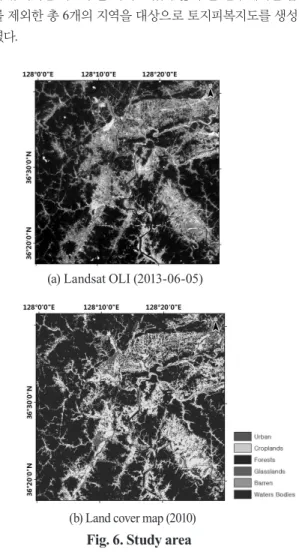
ISODATA는 최종 클래스의 숫자가 정해지지 않은 것이 특 징이나, 본 연구에서와 같이 대분류 토지피복도를 이용하는 경우에는 클래스의 분류가 정해져 있어 연산시간을 줄이고 자 클래스 분류를 설정하였고, 기존 토지피복도의 클래스를 모두 포함하기 위하여 14개의 클래스를 변수를 조정하였으나, 본 연구에서는 토지피복지도 내의 클래스의 최대 4배 이상의 클래스를 생성하였다(Choi et al., 2014a).
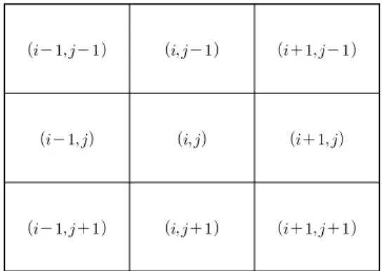
4배 이상의 클래스를 생성하기 위하여 최소 1개, 최대 26개 의 클래스가 생성되도록 ISODATA의 변수를 조절하였다. 한 편, 기존의 토지피복지도를 활용할 경우에는 토지피복지도와 위성영상 간의 생성 시기 내에 변화된 지역이 존재하여 훈련 자료에 오차가 발생할 수 있다. 이를 해결하기 위하여, Fig. 2 와 같이 기존 토지피복도에서 정의된 6개의 클래스특성을 고 려하여 2단계의 Decision tree를 생성하였다(Dickinson et al., 1993; Friedl et al., 1997; Pal et al., 2003). 1단계는 NDVI 영 상을 이용하여 식생의 유무로 분류하였고 2단계는 비식생지 역을 도심지, 나지, 수계로 분류하였으며, 식생지역은 농업지 역, 산림, 초지 등으로 구분하였다. 2단계의 분류에서는 각 클 래스의 선험확률을 가중치로 두어 적용하였으며, 다수 클래 스의 경우 보다 많은 화소수를 가지는 지역을 대표 클래스로 선정하였다.
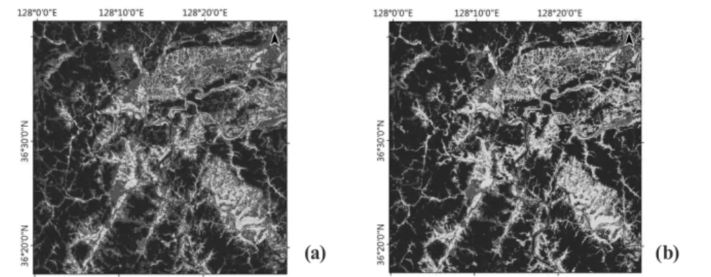
대표 클래스가 명명된 ISODATA 결과를 기존의 토지피복 지도와 비교하여 동일한 클래스를 지니는 화소들만 초기 훈 련자료로 할당하였다. 기존의 방법과 다르게 최대 26개의 클 래스로 명명된 것 중 6개의 대표 클래스만 추출되기 때문에 훈련자료의 양이 줄어들어 데이터 처리속도가 증가하였다. 또 한 각 클래스별 토지피복지도와 위성영상의 분광특성이 다
른 지역 및 변화지역들은 훈련자료로 결정되지 않는다. Fig. 3 은 기존의 토지피복지도와 명명된 ISODATA를 이용하여 초 기 훈련자료를 추출한 것으로, 각 클래스별로 대표되는 지역 이 아래의 범례에 따라 도식화되었다. 그림을 살펴보면 수계의 경우 수계 중심지역이 추출된 것을 알 수 있으며, 산림지역의 경우도 산 중심부가 추출된 것을 확인할 수 있다.
2.3 salt and pepper 오류 제거
화소기반의 분류 방법에서는 salt and pepper라 불리우는 오류가 발생하게 된다(Lu and Weng, 2007). 이와 같은 오류를 해결하기 위하여 객체기반의 분류가 제안되었으나(Blaschke, 2010), 이러한 방법은 많은 변수들이 필요하기 때문에 본 연 구에서는 이와같은 오류를 줄이는데 효과적인 MRF(Markov random fields)를 이용하여 오류를 줄이고자 하였다(Sui et al., 2012; Szeliski et al., 2008). MRF에서 화소(i,j)가 클래스
exp
ln
∈
if
if ≠
에 속할 확률은 Eqs.(1) and (2)와 같이 각 분광정보와 화소 (i,j)의 주변 화소값에 의해 결정된다.
exp
ln
∈
if
if ≠
(1) 여기에서 Z는 정규화상수,
exp
ln
∈
if
if ≠
와
exp
ln
∈
if
if ≠
은 context와 spectrum의 에너지,
exp
ln
∈
if
if ≠
은 각 클래스의 사전확률의 로그함 수에 의하여 결정된다.
exp
ln
∈
if
if ≠
(2)
본 연구에서 초기 사전확률은 기존의 토지피복도의 분포 Fig. 2. Hierarchical decision tree for
the land cover classification
Fig. 3. Training dataset corresponding to each class