Experimental Assessment of Satellite-based Positioning System for GIS Data Acquisition
Yongcheol SUH
1※GIS 데이터 취득을 위한 위성측위 환경의 실험적 평가
서 용 철
1※1ABSTRACT
Satellite-based positioning system such as global positioning system(GPS) has played a major role in data capture technology for constructing GIS database. Recent advances in satellite-based positioning technology have made the task of precisely locating features fast, easy, and inexpensive, and determined their current latitude and longitude. However, there are still situations where satellite-based positioning service will not provide users with desired precision such as in urban environments, that is, the only severe handicap still hampering satellite-based positioning is the well-known problem of restricted satellite visibilities. As the majority of the creation and updating of road and street network are carried out in urban environments, the obstruction problem considerably impedes the wider application of satellite-based positioning. This paper presents the current GPS-based positioning environment for GIS data acquisition in urban areas. A field experiment with measurement vehicle has been performed under varying operational conditions and areas where shading of satellite signal is encountered due to buildings and overpasses with measurement vehicle in order to evaluate the availability of existing GPS-based positioning. We found that the current GPS-base positioning system we used in this study was insufficient for a precise GIS data acquisition.
This research would make a contribution for the development of base data to supplementary technology, which can complement the existing GPS-based positioning.
KEYWORDS: GIS Data Acquisition, Satellite-based Positioning System, Global Positioning System
요 약
GPS를 대표로 하는 위성측위시스템은 GIS 데이터베이스 구축을 위한 데이터 취득에 있어서 중
2003년 10월 20일 접수 Received on October 20, 2003 / 2003년 12월 8일 심사완료 Accepted on December 8, 2003
1
日本 東京大學 土木工學科 Department of Civil Engineering, The University of Tokyo, Japan
※
연락저자 E-mail: [email protected]
요한 역할을 하고 있다. 또한 최근의 위성측위 기술의 발전은 보다 빠르고 쉽고 경제적인 방법으 로 대상물의 정확한 위치 정보의 취득을 가능하게 하였다. 그러나 도시공간 환경에 있어서는 수 많은 도시공간 구조물들로 인해 측위위성과 수신기 사이의 시통이 제한됨으로써 정확한 GIS 데 이터베이스 구축에 필요한 신뢰성 있는 위치정보 취득이 곤란하게 된다. 또한 대부분의 GIS 데이 터 생성과 갱신의 소요가 도시공간을 중심으로 이루어지고 있음을 고려할 때, 이와 같은 도시공 간에서의 위성측위를 통한 위치정보 취득의 곤란은, 정확하고 신속함을 필요로 하는 GIS 데이터 취득에 심각한 문제를 야기하게 된다. 따라서, 본 연구에서는 실제 도시공간에의 위치정보 취득을 위한 위성측위 환경을 평가하기 위해 차량측정장치를 사용하여 실제 도시공간을 대상으로 현장 실험을 수행하였다. 본 연구를 통하여 기존의 GPS 만을 이용한 위성측위 방식에서는 위치정보 데이터 취득에 한계성이 있다는 것을 파악할 수 있었으며, 이 결과는 향후 새로운 보완 측위 기 술 연구분야에서 유용한 기초자료로서 활용될 수 있을 것으로 사료된다.
주요어 : GIS 데이터 취득, 위성 측위, 범지구 위치결정 체계
INTRODUCTION
Geographical information systems (GIS) have been generating massive interest worldwide.
GIS is expected to represent real-world geographies in a structured, digital format that permits users to create, edit, manipulate, display, analyze, and output data. Most types of information or data include some kind of geographic and positioning component, which allow for a graphical representation of that information. Recent advances in GPS technology have made the task of precisely locating features fast, easy, and inexpensive, and determine position anywhere on the earth's surface in latitude/longitude coordinates to an accuracy of fractions of a second of arc. Its accuracy is already greater than that of the best base mapping commonly available in most countries.
For such satellite-based positioning system, the accuracy, availability and reliability of the satellite-derived position solution is highly dependent on the number of tracked satellites.
However, there are still situations where satellite-based positioning service will not
provide users with desired precision such as in urban environments, that is, the only severe handicap still hampering satellite-based positioning is the well-known problem of restricted satellite visibilities due to obstruction of buildings. As the majority of positioning data capture tasks are carried out in urban environments, the obstruction problem considerably impedes the wider application of satellite-based positioning.
However, many GIS applications nowadays require more accurate positioning information with the highest reliability. It is well known that reliable uninterrupted GPS operation can be usually realized only under an open sky or with minimum obstructions. Nevertheless, GPS cannot provide sufficient availability and continuity of service for GIS applications since the performance of existing systems may decrease under difficult operational conditions.
For example, in such urban environments
where GPS signals might be obstructed for
extended periods of time. Besides, undesirable
phenomenon such as carrier phase cycle slips
may hinder acquisition and keeping of the float
and fixed ambiguity solution Real Time
Kinematic (RTK) method generally has severe limitations when fewer than five satellites are in view. Under such a condition, RTK does not work at all or works very unreliably, and cannot avoid interruptions. Furthermore, if there are cycle slips, it needs some time to cover the problem, which requires an instantaneous ambiguity resolution or instantaneous positioning, and the issue of maintaining continuous lock and fast signal recovery after possible losses of GPS lock is essential in order to meet such stringent accuracy requirements. Therefore, it is crucial to evaluate the practical positioning environment in urban areas. This paper describes the current positioning environment for GIS data acquisition in urban environment.
Besides the general description of the approach, this paper describes the overall of measurement vehicle and schematic system setup in detail.
OUTLINE OF EXPERIMENTAL SYSTEM
In order to evaluate satellite-base positioning service, a field experiment has been performed under varying operational conditions and areas where shading of satellite signal is encountered due to buildings and overpasses. The system for the field experiment consists of a DGPS receiver, an Internal Navigation System (INS), a vehicle odometer, a Personal Computer (PC) and a measurement vehicle for driving trials as shown in Figure1. Especially, the DGPS receiver is composed of a L1 frequency (1575.4MHz) ASHTECH G-12 GPS receiver and medium frequency radio beacon that receives correction data on FM commercial radio at a regular time interval by the Japanese Maritime Safety Agency. Meanwhile, INS technology was used
in order to overcome the problem of GPS signal blockage in this experiment. The GPS, when operated in differential mode, is capable of providing very accurate position and velocity information when the carrier phase observable is used. Under ideal conditions, the GPS measurements are consistent in accuracy throughout the survey mission. However, such conditions do not often exist. Independent GPS navigation requires at least four satellites with good geometry. A major drawback of GPS is the accuracy degradation due to poor satellite geometry, cycle slips, satellite outages, and dynamic lag during maneuvers. This is especially prevalent in urban centers and when encountering highway overpasses or tunnels.
The INS measures linear acceleration and angular rates very accurately and with minimum time delay. For short time intervals, the integration of acceleration and angular rate results in extremely accurate velocity, position, and attitude with almost no noise or time lags.
However, because the INS outputs are obtained by integration, they drift at low frequencies. To obtain very accurate outputs at all frequencies, the INS should be updated periodically using external measurements. GPS velocities and positions are update measurements which complement the INS output in an ideal way.
The integration of GPS and INS, therefore,
provides a survey system that has superior
performance in comparison with either a GPS or
an INS stand-alone system. For instance, GPS
derived positions have approximately white
noise characteristics over the whole frequency
range. The GPS-derived positions and velocities
are therefore excellent external measurements
for updating the INS, thus improving its
long-term accuracy. Similarly, the INS can
provide precise position and velocity data for GPS signal acquisition and reacquisition after outage. This reduces the time and the search domain required for detection and correcting cycle slips. INS consists of GPS receiver, gyros and accelerometers. This integration is very similar to car navigation, which provide the user with precise position; the GPS measures position, the gyro sensor measures direction and the speed sensor measures distance. A measurement vehicle for driving trials has been developed by Asia Air Survey (AAS) Co. Ltd., is named Hybrid Inertial Surveying System (HISS). All equipment was mounted on the roof of the measurement vehicle. The alignment of equipment used is shown in Figure 2. The schematic system setup with emphasis on the vehicle's equipment is displayed in Figure 3. This system arrangement allowed simultaneous observation of measurements by using the GPS receivers connected to INS. We installed a highly accurate GPS receiver and tried to use the Virtual Reference Station (VRS) system of Japan Geographical Survey Institute (GSI) reference network during the experiment in order to obtain the real-time coordinates of measurement vehicle. The VRS is, currently, a network comprising of as many as 1,000 GPS-based control stations covering all over Japan in order to observe crustal movement for seismic prediction and research. However, VRS was not exploited during the course of this experiment because the number of visible satellites was not sufficient to reliably determine position and led to complete deficiency of positioning. Thus, the INS has been used inevitably for supplying the correction data instead of VRS system while the measurement vehicle run a course.
FIGURE 1. The measurement vehicle for driving trials
FIGURE 2. Alignment of the equipment used
DGPS Antenna GPS Antenna
Medium Frequency Radio Beacon
Antenna
INS GPS Receiver
Gyro Speed Encoder
DGPS Receiver GPS Receiver
Medium Frequency Radio Beacon
Receiver
Computer
FIGURE 3. Schematic system setup
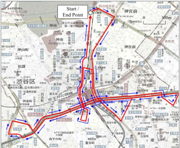
Start / End Point
0 300m
FIGURE 4. Map of testing site and the vehicle trajectory
EXPERIMENTAL RESULTS
The system has undergone extensive testing in Shibuya district of Tokyo. Figure 4 shows the map of the testing site as well as the vehicle trajectory obtained by HISS. The field experiment presented in this study was performed from 07:10 to 07:53 on December 13, 2002. Shibuya district contains extensive urban canyons, which cause significant GPS outage. The position could be computed position if the number of tracked satellites was three or more. Hence, with three satellites,
two-dimension solution could be obtained. The measurement vehicle ran a course at a low speed for obtaining stable range measurement, and measurement vehicle stopped at 25 discretionary points in order to compare the results of DGPS with INS data.
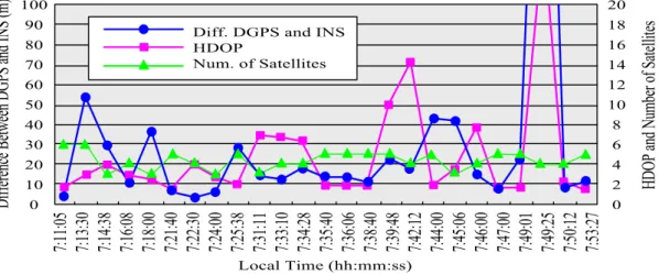
The number of visible satellites and the ratio of visible satellites (to total satellites) during the data collection are shown in Figure 5 and 6.
As shown in this figure, it can be seen that
although the measurement vehicle went
smooth, there were some jumps in HISS out,
which were mainly caused by erroneous GPS
signals. Figure 6 shows that only 51% of the
0 1 2 3 4 5 6 7
7:10 7:20 7:30 7:40 7:50
時刻
捕捉衛星 数
Local Time (hh:mm)
N um be r of S at el li te s
FIGURE 5. Number of visible satellites
0 5 10 15 20 25 30 35
0 1 2 3 4 5 6
捕捉衛星数
(%)比率
Number of Visible Satellites
Ratio (%)