Large-scale, Miocene Mud Intrusion into the Overlying Pleistocene Coastal Sediment, Pohang City, SE Korea: Deformation Mechanism, Trigger, and Paleo-seismological Implication for the 2017 Pohang Earthquakes
12
0
0
전체 글
(2) 586. Yong Sik Gihm et al.. 1. Introduction Earthquake-induced soft sediment deformation structures (SSDS) are near-surface deformation structures that have resulted from cyclic ground motions (> Mw 5.0) (van Loon, 2009; Owen et al., 2011). These motions give rise to an increase in pore water pressure in water-saturated, semi- to unconsolidated sediments, which temporarily supports the weight of sediment grains by pressure (liquefaction and thixotropy) and/or associated upward moving fluid (fluidization). These phenomena transform sediments from a solid to semi-liquid state with a decrease in sediment strength, resulting in the formation of SSDS, as driving forces act on the weakened sediments (Allen, 1982; Maltman and Bolton, 2003; Owen, 2003; van Loon, 2009). Earthquake-induced SSDS can develop over extensive areas as a result of the influence of wideranging ground shaking (Galli, 2000). Also, underground formation of the SSDS protects them from surface modifications, and they have a high preservation potential (Gihm et al., 2018). Thus, research on earthquake-induced SSDS can provide tectonic and/or paleo-seismic information, and many studies have been conducted with a tectonic and paleo-seismological focus (Leeder, 1987; Rossetti, 1999; Tuttle et al., 2002; Törő and Pratt, 2016). On November 15, 2017, a cluster of moderate ground motions (≤ Mw 5.5, the 2017 Pohang Earthquakes) shook Pohang city, SE Korea where 0.5 million residents live with a dense industrial complex. Because of the proximity (< 1 km) between the epicenter and a drilling site for the Pohang Enhanced Geothermal System, the cause of the 2017 Pohang Earthquake is a controversial issue (Grigoli et al., 2018; Kim et al., 2018). The Geological Society of Korea assessed the cause of the 2017 Pohang Earthquakes and determined that the earthquakes were triggered by the injection of water for hydrofracturing, which stimulated a buried fault that had reached a near-critical state by the accumulation of tectonic strain during the Quaternary (Lee et al., 2019). However, Quaternary faults and associated ground expressions have not been reported near the epicenter before the site construction.. During post-seismic field investigations, largescale, water-escaped structures were identified ca. 4 km from the epicenter. The water-escaped structures are sourced from underlying Miocene mudstones that have intruded into Pleistocene costal sediments deposited in Marine Isotope Stage 5 (MIS 5). Based on sedimentological analysis and consideration of the Quaternary geological context, this structure is interpreted to have been triggered by earthquakes. This indicates the occurrence of moderate to strong ground motions around the epicenter after the MIS 5. The objectives of this study are to describe the water-escaped structures and their host sediments, examine reasons why the Miocene mudstones were susceptible to deformation long after deposition, and investigate the causative trigger of the water-escaped structures in consideration of possible alternatives and the Quaternary geological context.. 2. Geological Backgrounds During the Late Oligocene, the SE Korean Peninsula began to undergo dextral, strike-slip deformation as a consequence of the opening of East Sea (Sea of Japan) (Jolivet et al., 1992; Yoon et al., 2014; Son et al., 2015) (Fig. 1). At ca. 22 Ma (Early Miocene), a series of NNW-SSW trending strike-slip fault systems produced nonmarine pullapart basin (Figs. 1A and B). The Early Miocene basin fill comprises fluvial, fluvio-lacustrine, and lacustrine sediments which are commonly intercalated with dacitic to basaltic volcanic and volcaniclastic rocks (Bahk et al., 1996; Jeong et al., 2008; Sohn et al., 2013; Son et al., 2015). As deformation continued, the NNW-SSE striking master fault (Yeonil Tectonic Line: YTL) propagated northwestward and connected with NNE-SSW trending fault systems, forming zigzag pattern, NNE-SSW and NNW-SSE trending, fault segments (Son et al., 2015) (Fig. 1A). The NNE-SSW trending segments acted as normal faults due to NW-SE extension induced by regional dextral shear stress, and opened the Pohang Basin ca. 17 Ma (Middle Miocene). Normal faulting propagated basinward, forming intrabasinal faults. To the west, the basin is bordered by the NNE-SSW trending fault system and the eastern boundary faults are submerged.
(3) Large-scale, Miocene Mud Intrusion into the Overlying Pleistocene Coastal Sediment .... 587. Fig. 1. (A) The distribution of the Miocene sediment basins in SE Korean Peninsula (After Son et al., 2015). (B-D) Temporal changes in the tectonic circumstance around the Korean Peninsula since the Miocene (B: early Miocene, C: middle to late Miocene, D: present) (After Yoon et al., 2014; Kim et al., 2016).. (Figs. 1A and 2A). In contrast to the Early Miocene basin fill, the Pohang Basin fill consists of alluvial to marine sediments and lacks volcaniclastic sediment. A high sediment supply sourced through transfer zone drainage systems caused the development of fan-delta systems along the western border fault, with the deposition of coarse-grained sediments (Hwang et al., 1995). Rapid block subsidence by normal faulting sufficiently accommodated the supply of coarse-grained sediment, and grey to dark-grey mudstones are the main lithofacies in central and eastern parts of the Pohang Basin (Sohn and Son, 2004) (Fig. 2A). Based on microfossil studies, these mudstones were deposited in upper to lower bathyal environments (Kim, 1990; Kim. and Paik, 2013). At ca. 15 Ma, collision of the Izu-Bonin Arc and Japanese Island by northward migration of the Philippine Sea Plate gave rise to counter-clockwise rotation of the Honshu Block (Yoon et al., 2014). The resultant NNW-SSE trending stress regime caused tectonic inversion in the SE Korean Peninsula from NW-SE extension to compression (Fig. 1C). This progressively uplifted the southeastern part of the Korean Peninsula, and sedimentation in the Pohang Basin ceased by ca. 10 Ma (Hwang et al., 1995; Cheon et al., 2012; Son et al., 2015). Since ca. 5 Ma, the Korean Peninsula has been under influence of E-W to ENE-WSW stress fields by the combined effects of the shallow subduction.
(4) 588. Yong Sik Gihm et al.. Fig. 2. (A) The geological map of the Miocene sediment fills in the Pohang Basin and outcrops and trench sites of the Quaternary fault (combined figure after Choi et al. 2012; Song et al., 2015). The Pohang Basin is composed of alluvial to deep marine sediments, covered unconformably by the Quaternary coastal deposits along the eastern shorelines. (B) A schematic distribution map of marine terraces of the study area (Choi et al., 2009). The three flights of coastal deposits are well developed, and the water-escaped structures occur at interface between the Miocene mudstones and the highest marine terrace (NQT3).. of the Pacific Plate and far field stress from the Indian Plate collision (Yoon et al., 2014) (Fig. 1D). The compressional tectonic forces uplifted the SE Korean Peninsula and developed a series of coastal deposits (Choi et al., 2008; Choi, 2019). Most of the coastal deposits formed during MIS 5e to 5a under a wave-dominated, open coastal setting together with negligible tidal influence (< 1 m; Choi et al., 2008). In addition, compressional tectonic stress reactivated pre-existing faults, such as the Yangsan and Ulsan faults, and formed the Quaternary fault segments (Kim et al., 2016). Those along the Yangsan Fault (NNE-SSW to NESW striking) show dextral strike-slip movement with reverse slip, whereas in those along the Ulsan Fault (NNW direction) thrusts are common (Kim et al., 2016). Recently, the 2017 Pohang Earthquakes were caused by the movement of subsurface intrabasinal faults in the Pohang Basin.. 3. Host Sediments The water-escaped structures occur over the Miocene and Pleistocene sediments in the eastern part of the Pohang Basin (Figs. 2 and 3). In this area, both the Miocene and the Pleistocene sedimentary successions have been excavated for railroad construction, exposing a 500 m long (E-W) and ca. 10 m high section of strata (Fig. 3A). The host sediments are composed of the Miocene mudstones and overlying the Pleistocene sand and gravel units. Their contact is 35 m a.s.l. (above sea-level), corresponding to NQT3 terrace (127±17 Ka) of Choi et al. (2009) (Figs. 2B and 3A). The mudstones contain the plant leaves Carpinus kodairae-bracteata, C. miofargesiana, C. oblongibracteata (Kim et al., 2017) and Cosmopolitodus hastalis and Kentridom teeth (Kim et al., 2018; Lim, 2005). All became extinct in the Miocene, indicating deposition of the mudstone in the Miocene. In the railroad cutting,.
(5) Large-scale, Miocene Mud Intrusion into the Overlying Pleistocene Coastal Sediment .... 589. Fig. 3. Outcrop photographs along the interface between the Miocene mudstones and the Pleistocene sediments. (A) Two water-escaped structures with reverse funnel shapes and the Pleistocene coastal deposits between the structures. (B) A present-day collapsed slope with continuous discharge of groundwater from the unconformable interface between the Miocene and Pleistocene sediments. (C) Cracks (filled by the overlying Pleistocene sediments) in the topmost part of the mudstones.. Fig. 4. A sedimentologic log and photographs of the host sediments. (A) The stratigraphic log of the host sediments. (B) Massive features and carbonized plant fragments in the Miocene mudstones. (C) Photographs showing sharp boundary between the Pleistocene gravel and sand units. (D) Interbedded layers of sand and mud in the Pleistocene sand unit. (E) Vertical changes in asymmetric (ASR) to symmetric ripple (SR) in the sandy units. (F) A photograph of moderately to well sorted, rounded gravels with crude cross stratifications in the bed of gravel units. (G) Planar stratifications of the lens of sand in the gravel units..
(6) 590. Yong Sik Gihm et al.. the overlying Pleistocene sediments are friable, whereas the mudstones are moderately to semiconsolidated except for their topmost part which is still unconsolidated along with continuous discharge of groundwater (Figs. 3B and 4A). 3.1. Miocene mudstones The Miocene mudstones (< 5 m thick) are grey in color and composed of homogeneous silt and clay with plant debris (Figs. 4A and B). X-Ray Powder Diffraction (XRD) analysis demonstrated that the mudstones are composed mostly of quartz and montmorillonite (Fig. 5). Locally, vertical cracks (< 1 m long, Fig. 3C) are developed at the top, which are filled with overlying Pleistocene sediment. The mudstones are interpreted to have been deposited by (hemipelagic) settling of fine-grained sediments based on the fine-grained and homogeneous nature (Hwang et al., 1995). This interpretation is consistent with the observation of trace fossils such as Chondrites in the mudstones that suggest oxygen depletion (Kim and Paik, 2013). 3.2. Pleistocene deposits The Pleistocene deposits are situated between two water-escaped structures, exhibiting a bowl-like geometry (Fig. 3A). The deposits are composed of a lower sand and upper gravel unit (Figs. 4A and C). 3.2.1. Sand unit The sand unit is composed of moderately to well sorted silty sand to fine sand that are cm to tens of. Fig. 5. The results of quantitative X-ray powder diffraction (XRD) analysis of the Miocene mudstones.. centimeters thick, intercalated with thin muddy layers (Figs. 4A and D). The sand layers commonly show normal grading with asymmetric ripple (ASR) and symmetric ripple (SR) cross-lamination (Fig. 4A). ASRs consist of seaward-dipping, convex-up, and sigmoidal foresets without sharp brink points (Fig. 4E). They are commonly overlain by SRs with a gradual decrease in grain size. The sandy layers are commonly draped or overlain by a few cm thick mud layers (Fig. 4E). This unit is 2.5 m thick in total and overlain by the gravel unit with a sharp boundary. The normal grading with vertical transition from ASRs to SRs reflects that the sandy unit was deposited by decelerating, unidirectional to oscillatory flows. However, the ASRs have sigmoidal foresets with smooth brink points, suggesting that the unidirectional flows were influenced by oscillatory components during deposition (Dumas et al., 2005). Thus, the sandy unit is interpreted to have been deposited by combined flows, followed by oscillatory waves as unidirectional components waned (Duke et al., 1991). The intercalated mud layers imply relatively calm conditions between episodes of sand deposition. Thus, the sandy units are interpreted to have been deposited by storm waves at water depths between storm and fairweather wave base. 3.2.2. Gravel unit The overlying gravel unit is composed of wellbedded (0.1–0.4 m thick) pebble to cobble sized clasts (Figs. 4C and F). The clasts are well sorted and spherical or disc-shaped, but rod-shaped clasts are also common (Fig. 4F). They are clast-supported and voids are filled with well-sorted medium to coarse sand. The gravel beds are massive to lowangle cross-stratified and dip toward the presentday shoreline (Figs. 4A and F). The gravel beds are locally intercalated with thin (< 0.1 m), lenticular planar laminated sand beds or massive muds (Fig. 4G). Although the uppermost part of the gravel unit has been excavated, Choi et al. (2009) reported that the gravel unit was covered by aeolian sand dunes. The well-sorted rounded clasts, low-angle cross stratification and bedded nature indicate deposition of the gravel unit under wave action in upper foreshore to nearshore environments (Massari and.
(7) Large-scale, Miocene Mud Intrusion into the Overlying Pleistocene Coastal Sediment .... Parea, 1988). The planar laminated sand was presumably deposited by swash waves (Hart and Plint, 1995). The mud lenses suggest temporal interruption of wave agitation, probably related with episodic sea-level rise during MIS 5.. 4. Water-escaped Structures 4.1. Occurrence The water-escaped structures (5 m high) are recognized by the intrusion of the Miocene mudstone into the overlying Pleistocene deposits (Figs. 3A and 6). At the base of the Pleistocene sediments, the structures are 4 m wide and decrease in width upward to 0.5 m, showing a reverse funnel shape. Internally, the structures are entirely massive; however, at their margins, bedding and gravel clasts of the Pleistocene sand and gravel units are steeply inclined against the structures (Fig. 6). Their inclination laterally decreases asymptotically away from the structures. 4.1. Interpretation The upward decrease in width and inclined clasts against them indicate upward injection of unconsolidated mudstones into the overlying Pleistocene strata via liquidization (Owen, 1987). However, the mudstone was deposited earlier than 10 Ma and deformed after c.a. 0.125 Ma. The Miocene and Pleistocene sediments were deposited in different depositional environments under. 591. contrasting tectonic settings, although the vertical facies changes in the study area are similar to those of a progradational coastal sequence (Fig. 4A). The unconsolidated nature of the sediment resulted from uplift of the Pohang Basin before significant diagenesis (Son et al., 2015). In addition, hydraulic differences between the Miocene mudstone and the Pleistocene sediments caused the development of an aquifer at their unconformable interface. This resulted in the dissolution of chemical bonds in the mudstones with the saturation of water in pores at the topmost part (Hansen et al., 2007). Thus, although the mudstones (> 10 Ma) are much older than the overlying deposits (127 Ka), these combined effects made the topmost part of the mudstone water-saturated and unconsolidated. A water seepage from the boundary between the Miocene mudstones and the Quaternary sediments also indicates the presence of aquifer at the interface (Fig. 3B). Liquidization caused the transformation of sediment from solid to a semi-liquid state by the loss of strength (Allen, 1982). In the case of the mudstone, thixotropy or quick clay are possible deformation mechanisms for liquidization (Owen, 1987). However, the latter is negligible because of the abundant montmorillonite in the mudstones (Fig. 5). The montmorillonite is a swelling mineral and increases in liquid limit by a volume increase when wet (e.g., Hansen et al., 2007). Thus, thixotropy is only valid deformation mechanism.. Fig. 6. A photograph of contact between water-escaped structures and the Pleistocene host sediments. Inclined bedding planes and clasts (dashed line) are noteworthy..
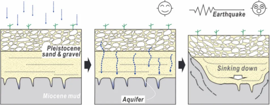
(8) 592. Yong Sik Gihm et al.. The mudstone transformed into semi-liquid state via an increase in pore water pressure induced by the re-arrangement of the water-saturated clay particles. The pressure was strong enough to inject the mudstone into the overlying deposits (fluidization; Owen, 1996) (Fig. 3).. 5. Discussion A causative trigger is necessary for the deformation mechanism to be activated. The weight of the gravel unit is a plausible endogenic trigger as the Quaternary gravel units prograded above the Miocene, semi-consolidated mudstones. In addition, wave-influenced sedimentary structures and bedforms in the Pleistocene deposits indicate that wave motion, including cyclic loading or breakage of waves, may also be a plausible trigger. Hourly wave records since 2010 (Pohang Buoy, N 36°21′ 00″, E 126°47′ 00″) show that significant wave height is 0.3 to 7.7 m during storm seasons, with the highest wave height 12.2 m (KMA, 2019). The maximum wave height is compatible to the optimum conditions for wave-induced liquidization (Alfaro et al., 2002). Constituent silty sand to fine sand in the sand unit is optimum grain size for liquefaction when these endogenic triggers occurred (Fig. 4). In addition, the sand and gravel layers in the Pleistocene deposits are commonly intercalated with muddy sediments. If deformation mechanism by the triggers acted on the Pleistocene sediments, well-developed, small-scale load and flame structures would be expected at the boundary because of the reverse density gradient (Owen, 2003). Thus, the. lack of SSDS indicates unsuitable physical conditions of the Pleistocene deposits at the time of the deformation, which may result from insufficient amount of water in pore space. Thus, we interpret that the deformation occurred after emergence of the Pleistocene sediments over the groundwater table by regional uplift in the SE Korean Peninsula, and insufficient volume of water hampered deformation of the Pleistocene deposit. The lack of SSDS in Pleistocene sediments also suggests that sediments passively sunk due to compensation for volume loss of the underlying injected mudstone (Fig. 3A). Another possible trigger is seismic shaking (Fig. 7). The water-escaped structures indicate that an elevated pressure by thixotropy exceeded the weight of the overlying Pleistocene deposits and intergranular friction of the clast-supported gravels, resulting in hydraulic fracturing of the Pleistocene deposits (Fig. 4). In addition, their unusually large size (< 4 m in width and > 5 m high) suggests severe liquidization of the topmost part of the mudstone together with significant volume loss by injection, causing subsidence of the Pleistocene sediments. Obermeier (1996) and Obermeier et al. (2005) pointed out that development of hydrofracturing and associated water-escaped structures needs significant strength and/or long duration of deformation mechanism. They suggested the usage of resultant clastic dikes and sills as paleoseismic indicators, because ground shaking during moderate to strong earthquakes (> Mw 5.0) meet these physical conditions. The Quaternary geological context also indicates. Fig. 7. A schematic model for the development of the water-escaped structures in the study area..
(9) Large-scale, Miocene Mud Intrusion into the Overlying Pleistocene Coastal Sediment .... active ground motion of the study area. Studies of the marine terraces in SE Korean Peninsula show that the elevation of marine terrace MIS 5e is 33 to 50 m a.s.l. was caused by E-W to ENE-WSW tectonic compression (Choi et al., 2008; 2009). The rates of uplift are 0.2 to 0.3 m/kyr since the late Pleistocene (Choi et al., 2008). Although the Korean Peninsula is located in an intraplate setting, this uplift rate is comparable to that of the presentday convergent margins (Choi et al., 2008). This active condition is also reflected by numerous historical records of moderate to hazardous historical earthquakes in SE Korea (Mw 5-7, A.D. 2 to A.D 1904) and moderate earthquakes (> Mw 5.0) recorded on seismographs since 1978 (Fig. 8). In addition, compressional tectonic stresses have stimulated pre-existing faults in SE Korea, such as the Yangsan and Ulsan faults, some of which has cut the Quaternary sediments, resulting in the development of Quaternary faults segments. In case of the Pohang Basin, more than five Quaternary fault outcrops have been reported near the western boarder fault (Choi et al., 2012) (Fig. 2A). Based on paleo-seismological research, the latest movements of these faults were estimated to have occurred after 125 ka, and one was evaluated to have generated strong earthquakes (Mw 6.5-7.5;. 593. Fig. 8. Historical and instrumental earthquake records in the SE Korea. Note frequent moderate to strong earthquakes since AD. 2, exceeding threshold for seismogenic liquidization (After Lee and Yang, 2006).. Kim and Jin, 2006.). Furthermore, during the postseismic investigation of the 2017 Pohang Earthquakes, a Quaternary fault was identified 400 m. Fig. 9. (A) Location and (B) photographs of the Quaternary fault at the nearby study area..
(10) 594. Yong Sik Gihm et al.. away from the study area (Fig. 9), which cut coastal deposits of NQT2 or NQT3 terraces (Choi et al., 2019). This implies the occurrence of moderate to strong paleo-earthquakes near the study area, because near-surface faults commonly involve earthquakes exceeding Mw 5.5 (Bonilla, 1988; Wells and Coppersmith, 1994). These lines of the evidence strongly indicate that earthquake(s) occurred in and around the study area after MIS 5, and their magnitudes exceeded the minimum threshold for liquidization (> Mw 5.0). The water-escaped structures are geological evidence of paleo-seismic activity around the Pohang Enhanced Geothermal System site. However, it does not directly indicate that the fault that caused the 2017 Pohang Earthquakes caused the development of water-escaped structures. Seismically induced SSDS form anywhere if sufficient cyclic shear stress propagates through susceptible sediments. In addition, the limited areal distribution of Quaternary sediments and ground modification by industrial development near the study area has hampered detection of the epicenter and magnitude of the causative earthquakes. Nevertheless, the water-escaped structures plus the nearby Quaternary faults show that the eastern part of the Pohang Basin is a paleosismologically active area under the influence of Quaternary tectonic stress fields, and pre-existing faults and weaknesses would be susceptible to rupture by small changes in local stress fields, such as fluid injection at the Pohang Enhanced Geothermal System.. 6. Conclusions During the post-seismic field investigation of the 2017 Pohang Earthquakes, large-scale, waterescaped structures were identified 4 km away from the epicenter. The structures were developed in the eastern part of the Pohang Basin, crosscut Pleistocene coastal deposits and were sourced from the underlying Miocene Mudstones. The structures were formed by elevated pore water pressure in the mudstone by thixotropy as the result of tectonic uplift before significant diagenesis and the development of an aquifer at their unconformable upper interface. The increased pressure was triggered by strong ground motions, probably induced by activity of the nearby Quaternary fault. (ca. 400 m from the study area). This study showed that the eastern part of the Pohang Bain is paleosismologically active. Thus, the fault that generated the 2017 Pohang Earthquakes may have been at a near-critical state, and an increased pore pressure by the water injection at the Pohang Enhanced Geothermal System was enough to stimulated the fault.. Acknowledgement This study was supported by KIGAM’s projects “Research in active tectonics and development of fault segment model for intraplate regions” and “Geological survey in the Korean Peninsula and publication of the geological maps” funded by Ministry of Science and ICT. This work was also supported by the National Research Foundation of Korea (NRF) grant funded by the Korea government (MSIT) (No. 2020R1F1A1070752). This manuscript has been improved by constructive comments from two reviewers.. References Alfaro, P., Delgado, J., Estévez, A., Molina, J.M., Moretti, M. and Soria, J.M. (2002) Liquefaction and fluidization structures in Messinian storm deposits (Bajo Segura Basin, Betic Cordillera, southern Spain). International Journal of Earth Sciences, v.91, p.505-513. Allen, J.R.L. (1982) Sedimentary structures: their character and physical basis. Vol. II, Elsevier, Amsterdam, 663p. Bahk, J.J. and Chough, S.K. (1996) An interplay of synand intereruption depositional processes: the lower part of the Jangki Group (Miocene), SE Korea. Sedimentology, v.43, p.421-438. Bonilla, M.G. (1988) Minimum earthquake magnitude associated with coseismic surface faulting: Bulletin of the Association of Engineering Geology, v.25, p.17-29. Cheon, Y., Son, M., Song, C.W., Kim, J.-S. and Sohn, Y.K. (2012) Geometry and kinematics of the Ocheon Fault System along the boundary between the Miocene Pohang and Janggi basins, SE Korea, and its tectonic implications. Geosciences Journal, v.16, p.253-273. Choi, S.J. (2019) Review on Marine Terraces of the East Sea Coast, South Korea : Gangreung – Busan. Economic and Environmental Geology, v.52, p.409-25. Choi, S.J., Merritts, D.J. and Ota, Y. (2008) Elevations and ages of marine terraces and late Quaternary rock uplift in southeastern Korea. Journal of Geophysical Research: Solid Earth, v.113, p.B10403. Choi, J.H., Kim, J.W., Murray, A.S., Hong, D.G., Chang, H.W. and Cheong, C.S. (2009) OSL dating of marine terrace sediments on the southern coast of Korea with implications for Quaternary tectonics. Quaternary.
(11) Large-scale, Miocene Mud Intrusion into the Overlying Pleistocene Coastal Sediment ... International, v.199, p.3-14. Choi, J-H., Ko, K., Gihm, Y.S., Cho, C.S., Lee, H., Song, S. K., Bang, E, S., Lee, H-J., Bae, H.K., Kim, S.W., Choi, S-J., Lee, S.S. and Lee, S.R. (2019) Surface Deformations and Rupture Processes Associated with the 2017 Mw 5.4 Pohang, Korea, Earthquake. Bulletin of the Seismological Society of America, v.109, p.756769. Choi, S.-J., Jeon, J.-S., Song, K.-Y., Kim, H.-C., Kim, Y.H., Choi, P.-Y., Chwae, U.C., Han, J.-G., Ryoo, C.-R., Sun, C.-G., Jeon, M.S., Kim, G.-Y., Kim, Y.-B., Lee, H.J., Shin, J.S., Lee, Y.-S. and Kee, W.-S. (2012) Active faults and seismic hazard map. National emergency Management Agency, Seoul, Korea, 882p. Duke, W.L., Arnott, R.W.C. and Cheel, R.J. (1991) Shelf sandstones and hummocky cross stratification: New insight on a stormy debate. Geology, v.19, p.625-628. Dumas, S., Arnott, R.W.C. and Southard, J.B. (2005) Experiments on oscillatory-flow and combined flow bed forms: Implications for interpreting parts of the shallow marine rock record: Journal of Sedimentary Research, v.75, p.501-513. Galli, P. (2000) New empirical relationships between magnitude and distance for liquefaction. Tectonophysics, v.324, p.169-187. Geological Society of Korea (2019) Summary report of the Korean Government Commission on relations between the 2017 Pohang earthquake and EGS project. Geological Society of Korea, Seoul, Korea, 346 p. Gihm, Y.S., Kim, S. W., Ko, K., Choi, J-H., Bae, H., Hong, P. S., Lee, Y., Lee, H., Jin, K., Choi, S-J., Kim, J.C., Choi, M. S. and Lee, S. R. (2018) Paleoseismological implications of liquefaction-induced structures caused by the 2017 Pohang Earthquake. Geoscience Journal, v.22, p.871-880. Grigoli, F., Cesca, S., Rinaldi, A.P., Manconi, A., LópezComino, J.A., Clinton, J.F., Westaway, R., Cauzzi, C., Dahm, T. and Wiemer, S. (2018) The November 2017 Mw 5.5 Pohang earthquake: a possible case of induced seismicity in South Korea. Science, v.360, p.1003-1006. Hart, B. S. and Plint, A. G. (1995) Gravelly shoreface and beachface deposits, In Plint, A. G. (ed.), Clastic facies analysis. International Association of Sedimentologists Special Publication, v.22, p.75-99. Hansen, L., Eilertsen, R.S., Solberg, I.-L., Sveian, H. and Rokoengen, K. (2007) Facies characteristics, morphology and depositional models of clay-slide deposits in terraced fjord valleys, Norway. Sedimentary Geology, v.202, p.710-729. Hwang, I.G., Chough, S.K., Hong, S.W. and Choe, M.Y. (1995) Controls and evolution of fan delta systems in the Miocene Pohang Basin, SE Korea. Sedimentary Geology, v.98, p.147-179. Jeong, J.O., Kwon, C.W. and Sohn, Y.K. (2008) Lithofacies and architecture of a basinwide tuff unit in the Miocene Eoil Basin, SE Korea: modes of pyroclastic sedimentation, changes in eruption style, and implications for basin configuration. Geological Society of America Bulletin, v.120, p.1263-1279. Jolivet, L., Fournier, M., Huchon, P., Rozhdestvenskiy, V.S., Sergeyev, K.F. and Oscorbin, L.S. (1992) Cenozoic intracontinental dextral motion in the Okhotsk-Japan. 595. Sea Region. Tectonics, v.11, p.968-977. Kim, W.H. (1990) Significance of Early to Middle Miocene planktonic foraminiferal biostratigraphy of the E-core in the Pohang Basin, Korea. Journal of Paleontological Society of Korea, v.6, p.144-164. Kim, Y.S. and Jin, K. (2006) Estimated earthquake magnitude from the Yugye Fault displacement on a trench section in Pohang, SE Korea. Journal of the Geological Society of Korea, v.42, p.79-94 (in Korean with English abstract). Kim, J. and Paik, I.S. (2013) Chondrites from the Duho Formation (Miocene) in the Yeonil Group, Pohang Basin, Korea: Occurrences and paleoenvironmental implications. Journal of the Geological Society of Korea, v.49, p.407-416 (in Korean with English abstract). Kim, J.H., Nam, K.S. and Jeon, Y.S. (2017) Diversity of Miocene fossil Acer from the Pohang Basin, Korea. Journal of the Geological Society of Korea, v.53, p.387405 (in Korean with English abstract). Kim, S-H., Park, J-Y. and Lee, Y-N. (2018) A tooth of Cosmopolitodus hastalis (Elasmobranchii: Lamnidae) from the Duho Formation (Middle Miocene) of Pohangsi, Gyeongsangbuk-do, South Korea. Journal of the Geological Society of Korea, v.54, p.121-131 (in Korean with English abstract). Kim, K.-H., Ree, J.-H., Kim, Y., Kim, S., Kang, S.Y. and Seo, W. (2018) Assessing whether the 2017 Mw 5.4 Pohang earthquake in South Korea was an induced event. Science, v.360, p.1007-1009. Kim, M-C., Jung, S., Yoon, S., Jeong, R-Y., Song, C, W. and Son, M. (2016) Neotectonic crustal deformation and current stress field in the korean peninsula and their tectonic implications: A review. Journal of Petrology of Korea, v.25, p.169-193 (in Korean with English abstract). KMA, The wave records of the Pohang Buoy since 2010: https://data.kma.go.kr/data/sea/selectBuoyRltmList.do? pgmNo=52 (December, 2019). Lee, K. and Yang, W.S. (2006) Historical seismicity of Korea: Bulletin of the Seismological Society of America, v.96, p.846-855. Lee, K.-K., Ellsworth, W.L., Giardini, D., Townend, J., Ge, S., Shimamoto, T., Yeo, I.-W., Kang, T.-S., Rhie, J., Sheen, D.-H., Chang, C., Jeong-Ung, W. and Langenburch, C. (2019) Managing injection-induced seismic risks. Science, v.364, p.730-732. Leeder, M.R. (1987) Sediment deformation structures and the palaeotectonic analysis of sedimentary basins, with a case-study from the Carboniferous of northern England. In: Jones, M.E., Preston, R.M.F. (ed.), Deformation of Sediments and Sedimentary Rocks. Geological Society London, Special Publications, v.29, p.137-146. Lim, J.D. (2005) The first dolphin fossil from the Miocene of Korea. Current Science, v.89, p.939-940. Maltman, A.J. and Bolton, A. (2003) How sediments become mobilized. In: Van Rensbergen, P., Hillis, R.R., Maltman, A.J. and Morley, C.K. (ed.), Subsurface sediment mobilization. Geological Society of London, Special Publications, v.216, p.9-20. Massari, F. and Parea, G.C (1988) Progradational gravel beach sequences in a moderate- to high-energy, microtidal marine environment. Sedimentology, v.35, p.881-913. Massari, F., Ghibaudo, G., D'Alessandro, A. and Davaud, E. (2001) Water-upwelling pipes and soft-sediment defor-.
(12) 596. Yong Sik Gihm et al.. mation structures in Lower Pleistocene calcarenites (Salento, southern Italy). Bulletin of the Geological Society of America, v.113, p.545-560. Obermeier, S.F. (1996) Use of liquefaction-induced features for paleoseismic analysis - an overview of how seismic liquefaction features can be distinguished from other features and how their regional distribution and properties of source sediment can be used to infer the location and strength of Holocene paleo-earthquakes. Engineering Geology, v.44, p.1-76. Obermeier, S.F., Olson, S.M., Green, R.A. (2005) Field occurrences of liquefaction-induced features: a primer for engineering geologic analysis of paleoseismic shaking. Engineering Geology, v.76, p.206-234. Owen, G. (1987) Deformation processes in unconsolidated sands. In: Jones, M.E. and Preston, R.M.F. (ed.), Deformation of sediments and sedimentary rocks. Geological Society Special Publication, v.29, p.11-24. Owen, G. (1996) Experimental soft-sediment deformation: structures formed by the liquefaction of unconsolidated sands and some ancient examples. Sedimentology, v.43, p.279-293. Owen, G. (2003) Load structures: gravity-driven sediment mobilization in the shallow subsurface. In: Van Rensbergen, P., Hillis, R.R., Maltman, A.J., and Morley, C.K. (ed.), Subsurface Sediment Mobilization. Geological Society of London, Special Publications, v.216, p.21-34. Owen, G., Moretti, M. and Alfaro, P. (2011) Recognising triggers for soft-sediment deformation: current understanding and future directions. Sedimentary Geology, v.235, p.133-140. Rossetti, D.F. (1999) Soft-sediment deformation structures in late Albian to Cenomanian deposits, Saõ Luís Basin, northern Brazil: evidence for palaeoseismicity. Sedimentology, v.46, p.1065-1081. Sohn, Y.K. and Son, M. (2004) Synrift stratigraphic geometry in a transfer zone coarse-grained delta complex, Miocene Pohang Basin, SE Korea. Sedimentology, v.51, p.1387-. 1408. Sohn, Y.K., Ki, J.S., Jung, S., Kim, M.-C., Cho, H. and Son, M. (2013) Synvolcanic and syntectonic sedimentation of the mixed volcaniclastic–epiclastic succession in the Miocene Janggi Basin, SE Korea. Sedimentary Geology, v.288, p.40-59. Son, M., Song, C.W., Kim, M.-C., Cheon, Y., Cho, H. and Sohn, Y.K. (2015) Miocene tectonic evolution of the basins and fault systems, SE Kora: Dextral, simple shear during the East Sea (Sea of Japan) opening. Journal of the Geological Society, v.172, p.664-680. Song, C.W., Son, M., Sohn, Y.K., Han, R., Shinn, Y.J. and Kim, J.-C. (2015) A study on potential geologic facility sites for carbon dioxide storage in the Miocene Pohang Basin, SE Korea. Journal of the Geological Society of Korea, v.51, p.53-66 (in Korean with English abstract). Törő, B. and Pratt, B.R. (2016) Sedimentary record of seismic events in the Eocene Green River Formation and its implications for regional tectonics on lake evolution (Bridger Basin, Wyoming). Sedimentary Geology, v.344, p.175-204. Tuttle, M.P., Schweig, E.S., Sims, J.D., Lafferty, R.H., Wolf, L.W. and Haynes, M.L. (2002) The earthquake potential of the New Madrid seismic zone: Bulletin of the Seismological Society of America, v.92, p.20802089. van Loon, A.J. (2009) Soft-sediment deformation structures in siliciclastic sediments: an overview. Geologos, v.15, p.3-55. Wells, D.L. and Coppersmith, K.J. (1994) New empirical relationships among magnitude, rupture length, rupture width, rupture area, and surface displacement. Bulletin of Seismological Society of America, v.84, p.974-1002. Yoon, S.H., Sohn, Y.K. and Chough, S.K. (2014) Tectonic, sedimentary, and volcanic evolution of a back-arc basin in the East Sea (Sea of Japan). Marine Geology, v.352, p.70-88..
(13)
수치


관련 문서
pISSN 1225 7281 eISSN 2288 7962 자원환경지질, 제53권, 제6호, 781 792, 2020 Econ Environ Geol , 53(6), 781 792, 2020 http //dx doi org/10 9719/EEG 2020 53 6 781
pISSN 1225 7281 eISSN 2288 7962 자원환경지질, 제53권, 제5호, 553 564, 2020 Econ Environ Geol , 53(5), 553 564, 2020 http //dx doi org/10 9719/EEG 2020 53 5 553 울릉도
pISSN 1225 7281 eISSN 2288 7962 자원환경지질, 제53권, 제5호, 505 515, 2020 Econ Environ Geol , 53(5), 505 515, 2020 http //dx doi org/10 9719/EEG 2020 53 5 505 황해
pISSN 1225 7281 eISSN 2288 7962 자원환경지질, 제53권, 제4호, 441 477, 2020 Econ Environ Geol , 53(4), 441 477, 2020 http //dx doi org/10 9719/EEG 2020 53 4 441 오염
pISSN 1225 7281 eISSN 2288 7962 자원환경지질, 제53권, 제4호, 347 362, 2020 Econ Environ Geol , 53(4), 347 362, 2020 http //dx doi org/10 9719/EEG 2020 53 4 347 교질상
pISSN 1225 7281 eISSN 2288 7962 자원환경지질, 제53권, 제3호, 271 285, 2020 Econ Environ Geol , 53(3), 271 285, 2020 http //dx doi org/10 9719/EEG 2020 53 3 271
pISSN 1225 7281 eISSN 2288 7962 자원환경지질, 제53권, 제2호, 147 157, 2020 Econ Environ Geol , 53(2), 147 157, 2020 http //dx doi org/10 9719/EEG 2020 53 2 147 RACMO
pISSN 1225 7281 eISSN 2288 7962 자원환경지질, 제53권, 제1호, 11 21, 2020 Econ Environ Geol , 53(1), 11 21, 2020 http //dx doi org/10 9719/EEG 2020 53 1 11 1차원
