First author:Park, Eun Kyoung, Graduate School of Sang Myung University,
Tel:+82-10-9243-7559, E-mail:[email protected]Corresponding author:Koo, Bonhak, Sang Myung University,
Tel:+82-10-3412-1471, E-mail:[email protected]
Received:23 April, 2013. Revised:15 July, 2013. Accepted:30 July, 2013.
- 115 -
동강 생태․경관보전지역 내 비오톱(Biotope) 조성 계획
박은경1)․구본학2)
1)상명대학교 대학원․2)상명대학교
A Study on the Biotope Planning of Dong-gang River Watershed in Ecological and Landscape Conservation Area
Park, Eun Kyoung
1)and Koo, Bon Hak
2)1)Graduate School of Sang Myung University,
2)Sang Myung University.
ABSTRACT
This study was conducted to make a biotop planning and construct 3 types of biotop by each site conditions. Three sites of different types in ecological and scenery conservation area of the Dong-gang river were selected by expert brain-storming process and constructed terrestrial biotops and aquatic biotops. Targets of 3 sites were set up such as constructing a habitat for Kaloula borealis and an ecological education place, building a terrestrial biotopes and monitoring the natural vegetation succession, and constructing a habitat for Luciola unmunsana Doi.
The study results can be applied hereafter to ecological restoration projects, after construction of habitat, the priority should be prepare measures of monitoring and maintenance, hereafter continuous study on ecological restoration should be performed actively through construction of biotope and wild animals and plants habitat.
Key Words:Kaloula borealis, Luciola unmunsana Doi, Wildlife habitat, Ecological education,
Succession.
I. 서 론
급속한 산업화와 도시화는 녹지 및 서식지 훼손, 비오톱의 소멸과 파편화 현상이 심각한 상태에 이르렀다. 이는 생태계의 불균형이라는 심각한 생태환경문제를 초래하였으며, 생물종 및 서식지 보전 복원을 위한 다양한 노력들이 진행되고 있다.
독일의 경우 비오톱에 관한 연구가 활발히 진행되어, 다양성, 희귀성, 자연성, 면적 복원가 능성, 위험성, 서식지 잠재성, 토지이용강도 등 비오톱 및 생태계 평가항목들을 실제 적용하였 다. 국내의 연구로는, 비오톱 유형 및 분류에 관한 연구(Choi et al., 2008; Choi, 2010), 비오 톱 평가 및 평가지표에 관한 연구(Kim, 2010;
Ra et al., 2001), 비오톱 보전 관리 및 해결방 안에 관한 연구(Nam, 2010), 비오톱 구조 및 특성에 관한 연구(Ra․Lee, 2000), 비오톱 도면 화 작업에 관한 연구(O, 2001), 도시 내 비오톱 조성 및 모델 구성에 관한 연구(Koo․Kim, 1999; Jeong et al., 2000; Chae, 2004) 등의 연 구가 있다.
이들 연구는 주로 지표․유형․보전․관리 측면에 관점을 두고 있으며, 실제 조성된 비오 톱을 대상으로 비오톱 유형별 조성기법 및 사 례에 관한 연구는 비교적 미약한 실정이다. 또 한 비오톱은 토지이용형태와 함께 생물․생태 적인 요소가 잘 반영되어야 하나 기존 연구 사 례는 도시지역을 중심으로 진행되면서 토지이 용 및 토지피복분류와 거의 유사한 경향을 띠 고 있다.
한편, 생태적 보전 가치가 높은 공간을 대상 으로 다양한 법률에 의해 생태계 보전 목적의 법적 보호지역들이 지정되고 있으나, 인위적, 자연적 원인으로 훼손되거나 환경압에 노출되 어 있어 보전 전략이 시급한 실정이다.
따라서 본 연구는 표준화된 조성기법이나 물 리적․생태적 입지의 특성의 방법론이 적용된
기존 비오톱 조성 사례와는 달리 입지유형별 차 별화된 비오톱을 계획하고 실제 적용하는데 목 적이 있다.
II. 연구범위 및 방법
1. 연구범위 가. 시간적 범위
본 연구는 법적보호지역인 동강생태경과보전 지역을 대상으로 2012년 3월부터 2012년 11월 까지 8개월에 걸쳐 생물다양성 증진을 위한 비 오톱 개념을 도입하여 조사 및 기본계획을 수립 하고, 비오톱 유형별로 조성하였다.
나. 공간적 범위
본 연구 대상지는 강원도 영월, 평창, 정선 등 3개 군의 경계를 이루고 있는 동강유역으로 서 자연환경보전법에 의한 생태․경관보전지 역으로 지정되었다. 동강유역은 비교적 양호한 수환경과 다양한 어종, 높은 고유성, 천연기념 물 및 법적 보호종의 서식 등으로 인해 보전가 치가 높으나 지속적으로 무분별한 개발, 밀렵 행위 등 생태계 훼손, 래프팅, 주변 양식장 및 주택가의 오수로부터 노출되어 생태계에 부정 적인 영향을 미치고 있다. 이에 동강 생태계 보전을 위한 노력의 하나로 비오톱을 조성할 필요성이 제기되었다.
본 연구는 동강 생태․경관보전지역 내 입지
유형별로 3개의 대상지를 선정하였으며(Figure 1),
대상지 선정기준은 ① 생태․경관보전지역 내
훼손되거나 현재 훼손이 진행되고 있는 지역으
로서 생태계 유지를 위해 우선적으로 복원을 요
구하는 지역, ② 주민 및 지자체에서 생태복원
이 요구되는 지역, ③ 맹꽁이, 운문산 반딧불이,
도롱뇽, 북방산개구리 등 보호종 및 특수종의
서식 또는 서식 흔적이 발견된 지역으로 선정하
였다. 대상지의 입지유형에 따른 환경적 특징은
다음과 같다(Table 1).
Table 1. Site conditions.
Division Munsan-ri 626
(Village affecting)
Gyuram-ri 269 (Village adjacent)
Gyuram-ri 253 (Natural stream) Selection
standard
∙Destroyed and destroying area in ecological landscape protected area
∙Restoration required area by local government
∙Habitat or detected area of inhabited trace of protected species
Conditions of location
∙Flooded in rainy season due to poorly drained
∙Affected by nearby surrounding environment
∙Detecting Kaloula borealis’s habitat trace
∙Little far from town, but area interfered by nearby surrounding environment
∙Source of pollutants to Dong-gang river due to cultivation of resident → Outbreak occupational cancer
∙Detecting inhabited trace of various organism detection
∙Area under cultivation, due to adjacent to town
∙Abandoned wastes due to interruption of cultivation by resident → An inflow of waste, devastation
∙Detection of habitat of Luciola unmunsana Doi
∙Area has a source of water supply due to neighboring forest and a mountain stream
Natural environment
∙Keep humid in soil due to neighboring stream and water purification condition of large area due to poor drainage
∙Easy to secure a source of water supply from neighboring forests
∙Graceful landscape of Dong-gang river valley and cliff
∙Providing various organism habitats
∙Graceful landscape of higher ground, no people moving and no light
Humastic environment
∙Land utilization:storage
∙Occurrence of wildlife’s road-kill due to near roadways
∙Land utilization:arable land
∙Under cultivation by neighboring residents
∙Land utilization:storage
∙Interruption of cultivation by neighboring residents
Target Habitat for kaloula borealis Terrestrial Biotop Habitat for Luciola unmunsana Doi Figure 1. Location map and range of ecological landscape
protected area of the Dong-gang River Valley, Korea. (Edited by researchers based on Wonju Regional Environmental Office, 2008)
1) 문산리 626는 마을에서 조금 벗어나 있으 나, 인근 주변의 간섭을 받는 지역이다. 주변 산 림과 하천으로 인해 토양 내 습기를 유지하고 수원을 공급하며, 집중호우시 배수불량의 상습 적인 범람지역으로 넓은 정수 조건을 가지고 있 고 맹꽁이 서식 흔적이 발견된 지역이다.
2) 귤암리 269는 동강변 절벽위에 위치하여 경관이 매우 수려하고 다양한 생물서식지의 기 능을 하고 있다. 그러나 마을과 인접하여 경작활 동으로 인한 동강변으로 오염원이 유입되고 이 로 인해 환경압이 발생되고 있는 실정이다.
3) 귤암리 253은 마을 주민들의 영농활동 중
단으로 폐기물이 방치되어 황폐화된 지역이지
만 지대가 높아 경관이 수려하고 사람의 이동과
빛이 비추지 않는 지역이다. 또한 주변에 산림
이 우거져 있으며 산기슭에서 유입되는 계류로
지속적인 수원 확보가 가능하다.
Table 2. A Flora in the Dong-gang River Watershed.
Source Title Period Classification group
Korea water resources corporation
Environment impact statement of Yeongwol
multipurpose dam construction project. 1997 681 Ministry of environment Natural environment of Yeongwol-gun and
Jeongseon-gun (the Dong River Valley, Korea). 1998 482 Korea forest service A Report of investigation into Forest ecosystem
of the Dong River Valley, Korea. 1999 535
Gangwon-do
A Scientific Investigation of the Dong River Valley, Korea (Flows through the Yeongwol-gun, Pyeongchang-gun and Jeongseon-gun).
2000 699
Expert review panel of Yeongwol multipurpose dam
A report of investigation Into Yeongwol
multipurpose dam. 2000 188
Ministry of environment․
National environmental protection institute
A report of investigation into ecosystem of the
Dong River Valley, Korea. 2002 194
Lee et al. Flora in the Dong River Valley, Korea. 2002 551
Korea land corporation The planning method for a substitute habitat of
Biotope type in Major Korean Cities. 2006 552 Lee, H.J. & Hong, M.P. Scrutiny of ecosystem in ecological landscape
protected area of the Dong River Valley, Korea. 2007 556 Wonju regional environmental
office An observation report of ecosystem change. 2009 727
* Cultivated plant species, overlapped plant species, unrecorded plant species absent from the list.
2. 연구방법 및 과정
서식지와 비오톱을 구별하지 않는 경우가 있 으나, 본 연구에서의 서식지는 “한 종 또는 한 개체군의 서식 공간”에 제한하고 있으며, 비오 톱은 생물군집과 연결시켜 정의하고 있다.
본 연구는 선행연구를 근거로 주변 환경에 맞추어 현장조사, 문헌조사, 실내․외 작업으로 병행하여 수행하였다.
대상지 및 경계 설정과 주변 현황은 현장조 사와 위성지도를 병행하여 조사하였고 지형은 측량전문가에게 의뢰하였으며, 수문․향․음영 은 Arcview 3.3을 이용하여 분석하였다. 대상지 내 야생동․식물상 조사는 문헌자료와 인근 주 민을 대상으로 실시한 청문조사를 근거로 조사 하였다.
종합된 결과는 Auto CAD 2010과 Adobe
photoshop CS5를 사용하여 계획하였으며, 지속 적인 피드백 과정을 거쳐 목표종 서식기반 및 시설배치 등 주변 환경을 고려하였다.
III. 결과 및 고찰
1. 대상지 목표종 및 입지유형별 비오톱 방향 문헌자료와 인근 주민을 대상으로 실시한 청 문조사결과 야생동․식물상은 Table 2와 같이 나타났다. 현장조사와 문헌조사 결과 및 브레인 스토밍을 통해 대상지 선정과 목표종 설정, 입지 조건별 비오톱 유형 및 조성방향은 다음과 같다.
1) 맹꽁이 서식지로 적합한 문산리 626번지는
Korea Water Resources Corporation(2005), Korea
Land Corporation(2006), Jeong(2008), Ministry of
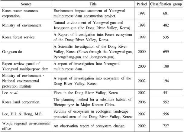
Figure 2. Basic plan and section of Munsan-ri 626.
Environment(2011), Ministry of Land Infrastructure and Transport(2013) 등에서 제시한 표준화된 조 성기법에 근거하여 맹꽁이 서식환경을 고려한 비 오톱 계획에 적용하였다.
2) 육생 비오톱을 목표로 한 귤암리 269번지 는 Wonju Regional Environmental Office(2007;
2008) 등 문헌자료와 인근 주민을 대상으로 실 시한 청문조사를 근거로 생태숲과 곤충류 서식 지 및 다양한 육상동물 서식환경을 조성하였다.
3) 귤암리 253번지는 과거 이 일대에 서식했 던 역사적 흔적에 근거하여 운문산 반딧불이를 목표종으로 설정하였으며, Lee(2007)가 제안한 반딧불 서식환경에 근거하여 사람의 이동과 불 빛이 거의 없고 먹이원인 달팽이류와 패각류가 많이 존재하는 습한 상태가 항상 유지되도록 지 형적 특성과 수환경을 고려하였다.
2. 문산리 626
주변 환경조건과 맹꽁이의 서식조건에 맞추 어 공간별 계획을 수행한 결과는 다음과 같다 (Figure 2).
맹꽁이의 서식조건상 습지의 면적은 50m
2이 상이 적합하나 맹꽁이의 다양한 서식공간과 그 외 다양한 생물의 서식지를 고려하여 총 1,570m
2의 면적 중 맹꽁이 서식지를 위한 습지는 381.5m
2로 전체 면적의 24%로 조성하였다.
개방수면의 비율은 산란을 위해 습지기능평 가방법인 RAM평가 기준에 25∼75%의 범위를 제안하나, 본 연구대상지는 주변 산림과 2m 이 내로 인접하여 81%의 개방수면을 적용하였다.
수원은 주변 산림으로부터 자연수로를 통해 유 입시키며, 홍수기 과잉의 빗물은 저류조에 저장 하였다가 수위가 내려가면 습지에 공급하는 시 스템으로 맹꽁이의 활동처, 번식처, 은신처 공 간을 유지되도록 하였다. 활동지는 겨울철 동결 또는 수온상승이 수생생물에 영향을 주지 않는 1m 이내로 산란지는 0∼30cm로 다양한 수심을 적용하였다. 습지의 가장자리는 불규칙적인 자 연스러운 형태로 조성하여 종다양성 효과를 기 대할 수 있고 경사는 0∼15°의 범위 내 다양하 게 적용하였다. 바닥은 부드러운 황토를 30cm 로 포설하여 맹꽁이의 이동과 활동이 용이하도 록 하였다. 또한 주변산림과 매우 인접하여 자 연스럽게 산림식생 연계와 야생동물의 이동통 로가 될 수 있다.
맹꽁이의 먹이가 될 수 있는 곤충류를 유인
하기 위해 동강유역 자생식물을 근거로 교목은
소나무, 마가목, 때죽나무 등과 수액식물로 일
부 나비류와 딱정벌레류에게 먹이를 제공하는
참나무류와 버드나무류를 선정하였다. 관목은
인동과 식물인 덜꿩나무, 백당나무와 꽃색이 화
려한 산철쭉 등을 선정하였다. 한편, 생물들의
서식지, 먹이, 번식, 은신처로 이용될 수 있도록
썩은 나무와 나뭇가지, 현장의 돌을 모아 다공
질 환경을 조성하였다. 습지 주변은 3∼20m 폭
의 완충식생대를 조성하여 맹꽁이의 다양한 먹
이원을 제공하고 주변 환경으로부터 보호하였
다. 주변 습지와의 거리는 20m로 가까운 위치
에 있으나, 인접 도로에 의해 단절된 상태로 포
유류 및 양서파충류의 로드킬 현상이 빈번하게
발생되어 경계부에 생태이동통로 기능을 갖는
배수로를 설치하여 로드킬 문제에 대응하였다.
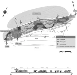
Figure 3. Basic plan and section of Gyuram-ri 269. Figure 4. Basic plan and section of Gyuram-ri 253.
3. 귤암리 269
육생 비오톱을 목표로 하여 안정한 생물서식 장소를 조성함으로써 소생물 서식 유도, 다양한 생물들의 네트워크 형성, 생물종의 서식환경 보 호, 자연환경 관찰학습 공간제공, 생태적 성역 조성, 모니터링 및 생태복원 방법과 기술 연구 를 위한 학술적 공간으로의 활용 등의 기능을 도입하였고, 가장 우선 조건으로 생물이 서식할 수 있는 식생구조를 조성하였다(Figure 3).
동강유역의 산림식생으로는 소나무군락이 주 로 분포하며, 학술적 가치가 있는 식물군으로 회 양목 군락지 및 비술나무, 시무나무 등과 암벽식 생인 돌단풍, 부처손 등이 있다. 또한 소나무하 늘소, 어름치, 수달, 황조롱이, 원앙 등 천연기념 물과 비오리 등 야생동물의 집단서식지로서 파 악되고 있다(Wonju Regional Environmental Office, 2007).
녹지면적은 602m
2의 면적으로 전체 면적 1,000m
2의 약 60%의 범위를 적용하였으며, 동 강유역 자생 식생을 근거로 교목은 소나무하늘 소 서식을 위한 소나무와 산사나무, 마가목, 복 자기 등을 식재하고 조류의 먹이원이 될 수 있 는 열매식물과 먹이를 줄 수 있는 먹이통을 배 치하여 휴식을 취할 수 있도록 하였다. 또한 인
동과 식물과 꽃색이 화려한 식물을 식재하는 것 뿐 만 아니라 장작쌓기, 돌무더기 등 육생비오 톱을 조성하여 다양한 곤충류를 유인하였다.
지형적 조건에 따라 바닥포장은 자연배수 등 친환경 소재인 마사토를 사용하였으며, 유지관 리를 위한 최소 동선으로 계획하였다. 또한 학 술적으로 가치를 높이기 위하여 자연스러운 식 생천이과정을 유도 및 관찰할 수 있도록 천이관 찰구간을 도입하였다.
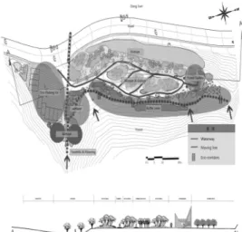
4. 귤암리 253
총 1,978m
2의 면적 중 69m
2의 습지를 조성하 였으며, 비오톱 조성과 함께 생태학습 공간으로 구분하였다(Figure 4).
운문산반딧불이는 흙으로 집을 만들기 때문에 토양이 건조해지지 않도록 유지하는 것이 중요하 므로 주변 산림과의 거리가 2m 이내에 위치하고 주변 산림에 의한 계류와 지속적인 수원 공급이 숲 내 습도를 높여주어 운문산반딧불이 및 먹이 자원이 되는 달팽이류 서식 조건을 제공하였다.
충분한 먹이원 공급과 산소의 공급을 위해 계류부의 경사는 10∼40° 범위로 조성하고 하 폭은 50∼200cm 내에서 다양하게 조성하였다.
연못은 10∼30cm 내에서 다양한 수심으로 조
Table 3. The planning elements.
Site
Elements Munsan-ri 626 Gyuram-ri 269 Gyuram-ri 253
Basic direction and object
∙To solve a poor drainage problem
∙Association with various neighboring forest ecosystem
∙To construct wetland or Eco-pond for improvement Biodiversity
∙To construct habitat for kaloula
borealis
∙To construct demonstration tagret to monitor a natural succession
∙To expect an effect of the natural vegetation succession with minimizing facilities
∙To create beautiful landscape in harmony with surrounding environment
∙To construct habitat for Luciola
cruciata Dai’s using a natural
mountain stream∙To make a gallery visitors can enjoy animals and plants in the Dong-gang river valley
∙To make a shelter for visitor
Habitat composition
Habitat for kaloula borealis (terrestrial/aquatic biotope)
Monitoring a process of succession (terrestrial biotope)
Habitat for Luciola unmunsana Doi (terrestrial/aquatic biotope) Rate of open
surface 81% - - Rate of open
surface 51%
Wetland area 381.5m2 / 1,570m2 Green area 602m2 / 1,000m2 Wetland area 69.0m2 / 1,978m2 Distance from
forest within 0-2m Distance from
forest within 0-200m Distance from
forest within 0-2m Vegetation type Multi-layered
lignosa
Vegetation type
Multi-layered lignosa
Vegetation type
Multi-layered lignosa
pH 9.7 - - pH 10.4
Water temperature 19.3°C - - Water
temperature 18.8°C Depth
of water
Spawning
pond 0-30cm - - Depth of water 10-30cm
Activity
place 1m - - Width of river 50-200cm
Soil loessial soil(30cm) Soil Surrounding soil Soil Loessial soil(30cm) Distance from
another wetland within 20m Distance from
another wetland within 10m Distance from
another wetland within 150m Slope of wetland 0-15° Slope of
surroundings 70-90° Slope of stream 10-40°
Buffer grassland 3-20m Buffer grassland 1-5m Buffer grassland 3-30m Utilization of
rainwater
Forest+Rainwater recycling facility
Utilization of rainwater
Natural drainage by topography
Utilization of
rainwater Natural stream
Paving plan
Using eco-friendly material
∙Habitat's floor:loessial soil
∙Parking lot:Lawn natural stone block pavement
∙The others:Boundary stone, loamy sand
∙The others:Boundary stone, loamy sand
∙Habitat's floor:loessial soil
∙Parking lot:Lawn natural stone block pavement
∙The others:Boundary stone, loamy sand
Circulation plan
A way of movement for rest and studying ecology
A minimal way of movement for maintenance
A way of movement for landscape and studying ecology
Present condition of
creation
성하고 산란에 적합한 온도를 유지하기 위해 개방수면이 50% 범위에 적용하였다. 연못주변 은 토양수분 및 육상 비오톱 조성을 위해 나뭇 가지와 돌무더기를 설치하였다. 연못 하단부에 는 산란조건인 이끼 형성에 유리하도록 수분을 유지하고 수목을 식재하여 그늘을 제공하였다.
또한 하상에 직경 10cm 이상의 통나무를 배치 하여 이끼 발생 조건을 제공하였고 다양한 생 육기반 조성을 위하여 직경 50cm 이상의 큰 돌을 설치하였다. 유속이 빠른 계류 지점은 토 양의 침식과 토사가 흘러 내려가는 것을 방지 하기 위해 사방댐(check dam)을 설치하여 유속 에 변화를 주었으며, 생태연못 내 수생식물을 활용하여 수질개선에 효과를 높였다. 수변식생 인 버드나무와 물억새를 식재하고 산림과 인접 한 부분은 다양한 곤충류를 위해 꽃이 화려한 산철쭉을 식재하였다. 습지 주변으로는 주변 산림의 돌무더기와 나뭇가지를 모아 육생비오 톱을 조성하여 다양한 생물의 환경을 유지하였 다. 또한 집중호우시 범람을 고려하여 일정 수 위를 넘어서면 기존 배수로에 연결하여 우회하 도록 하였다.
귤암리 253번지는 생태학습의 공간으로도 활 용된다. 자연계류를 이용한 반딧불이 서식지 공 간으로 운문산반딧불이의 생장기를 관찰할 수 있으며, 동강유역의 멸종위기종 동․식물 사진 을 전시하여 인근 주민들과 아이들, 동강유역을 방문하는 탐방객들에게 법적 보호종에 대한 중 요성과 지역이미지 홍보에도 중요한 역할을 제 공할 것이다.
본 연구에 적용된 입지유형별 계획을 요약하 면 Table 3과 같다.
IV. 결 론
본 연구는 생태․경관보전지역으로 지정된 동강유역 내 입지유형별로 3개소의 대상지를
선정하였고 기존 연구의 표준화된 모델과 각 대 상지 입지 여건을 고려하여 조성기법 및 방향을 설정하여 주변 생태환경과 연계한 육생 비오톱 및 수생 비오톱 공간을 조성하였다.
본 연구는 입지조건에 적합한 서식지 계획을 전 과정에 거쳐 진행되었으며, 입지유형별로 계 획과정 및 방법을 차별화하여 조성하였다는 점 에서 연구의 의의가 있다.
본 연구 결과는 향후 생태복원사업에 적용 가능할 것이라 판단되며, 특히 강원도 지역 내 의 멸종위기종Ⅱ급인 맹꽁이의 서식지 조성은 본 연구가 처음 시도하는 과제라 할 수 있다.
처음 시도하는 연구인만큼 유지관리 및 모니터 링이 중요하지만 이에 대한 예산이 부족하여 예 산확보가 시급한 상황이다. 따라서 생태계 보전 및 보호를 위해 주민참여형 유지관리가 이루어 진다면 생태보전 및 지역 이미지 홍보를 기대할 수 있을 것이다.
인 용 문 헌