INTRODUCTION
Stream health evaluation requires the simulta- neous observation of numerous parameters, in order to provide an accurate diagnosis for the selected streams or stream sites (National Instit- ute of Environmental Research, 2008). Diagnosis of stream health can be divided into two methods:
biological characterization-monitoring biological
entities, such as benthic diatoms, macroinverte- brates, and fish that reside in the streams, or stre- am physical environment monitoring including ha- bitat and riparian patterns. The former is manda- tory in order to obtain accurate information of stream ‘ecosystem’ health. However, not only does the seasonality of biological entities but also the high cost for monitoring often exacerbate the steam health monitoring process, even though they are necessary for ecological characterization. The lat-
─
─ 502 ──
* Corresponding author: Tel: +82-51-510-2258, Fax: +82-51-583-0172, E-mail: [email protected]
Relationships among a Habitat-Riparian Indexing System (HIS), Water Quality, and Land Coverage: a Case Study in the Main
Channel of the Yangsan Stream (South Korea)
Jeong, Kwang-Seuk, Dong-Kyun Kim
1, Dong-Kyun Hong, Jong-Yun Choi, Ju-Duk Yoon and Gea-Jae Joo*
(Department of Biological Sciences, Pusan National University, Busan 609-735, Korea
1School of Computer Science & Engineering, Seoul National University, Seoul 151-721, Korea)
In this study a total of 27 stream sites, at 1 km intervals, were monitored for simple physicochemical water characteristics, land coverage patterns, and stream environ- ment characteristics using the Habitat-riparian Indexing System (HIS), in the Yangsan Stream. The HIS has been tested in previous research, resulting in some identification of advantages in the application to the stream ecosystems data. Even though reliable stream environment characterization was possible using HIS, there was no informa- tion about the application of this tool to present continuity of environmental changes in stream systems. Also the necessity was raised to compare the results of HIS applica- tion with land coverage information in order to provide useful information in manage- ment strategy development. The monitoring results of this study showed that changes of environmental degradation were well represented by HIS. Especially, stream envi- ronment degradation due to construction was relatively well reflected in the HIS monitoring results, and the main causality of Yangsan Stream degradation was expan- sion of the urbanized area. In addition, there were significant relationships between the HIS scores and land coverage information. Therefore, it is necessary to prepare appropriate options in controlling or managing the expansion of the industrialized areas in this stream basin in order to improve the stream environment. For this pur- pose, ensemble utilization of HIS results, water quality, and geographical information, resulting in integration with remote sensing processes can be possible.
Key words : Habitat-riparian Indexing System (HIS), stream characteristics, Yangsan Stream, land coverage, water quality
ter can be fast applied to the stream systems, to investigate the degradation of environmental fac- tors (Lee and Kim, 1999; Kim et al., 2003; Park et al., 2006; Ahn, 2007).
The Habitat-riparian Indexing System (HIS) was reported as a good solution for the detection and diagnosis of environmental degradation in stream systems (Jeong et al., 2008). The Stream monitoring results using the HIS in the Nakdong River basin revealed the following advantages: (1) fast monitoring, (2) intuitive expression, and (3) monitoring result stability. As aforementioned, an accurate assessment of stream ecosystem health needs to combine both biological and non-biologi- cal characteristics, but pre-monitoring using the HIS in a stream system can provide basic infor- mation about the status of stream environment.
The biological investigation can be accompanied later with the HIS monitoring if necessary. How- ever, Jeong et al. (2008) successfully tested this
tool in different stream systems involving wide spectrum of environment characteristics (large river to small mountainous streams, urbanized and well preserved streams), they were failed to compare a continuous changes of the scores along with the stream pathway. This is an important issue because current stream restoration activities in South Korea are not restricted at one site but at least reach level of stream is under considera- tion.
Furthermore, it is important to discover the rela- tionship between the stream environmental cha- racteristics with land coverage information. Land cover is a good information source for stream cha- racterization because it conveys knowledge of pos- sible anthropogenic impacts to the stream. Vari- ous scientific research projects have been imple- mented to assess out the relationship between land cover and stream ecosystem characteristics (e.g. Lammert and Allan, 1999; Pan et al., 1999;
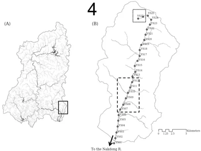
Fig. 1. Map of the study sites. A, Map of the Nakdong River basin and the location of the Yangsan stream; B, the Yangsan Stream basin and the distribution of the study sites. Solid box in panel A indicates the location of the Yangsan Str- eam; broken box in panel B indicates the downtown area of the Yangsan City; dotted box in panel B indicates the location of the Tongdo Temple area.
(A) (B)
YS27 YS25 YS24 YS23 YS22 YS21 YS20 YS19 YS18 YS17 YS16 YS15 YS14 YS13 YS12 YS11 YS10 YS09
YS08 YS07 YS06 YS05 YS04 YS03 YS02 YS01
0 1.25 2.5 5
To the Nakdong R.
Kilometers
Fore and Grafe, 2002; Sutherland et al., 2002), however most of the research applied to Korean streams were biased towards hydrological mana- gement.
In this study, we monitored a small stream sys- tem, the Yangsan Stream located in the southeast- ern part of the Nakdong River basin, to evaluate the utility of HIS for the representation of envi- ronmental continuity. In addition, land coverage patterns at the study sites in the stream as well as some basic water physicochemical characteris- tics were simultaneously monitored during the study period, in order to discuss further utility of the HIS tool for the stream environment mana- gement.
The Yangsan Stream flows 32.3 km and covers ca 243 km
2, originated from Chuiseo Mountain in Habook Myeon, Kyeongsangnamdo Province. This stream locates in the Southeastern area of the Nakdong River basin, and confluent to the River.
The confluent site is ca 20 km upper from the Nakdong Estuarine Barrage. About 220,000 resi- dents are in the stream basin currently, and most- ly the stream is utilized as agricultural and indus- trial water resource. In recent decades, not only the size of population but also the number / area of industrial complexes exhibited a gradual ten- dency of increase (Park et al., 1999), which is bel- ieved as the primary factor affecting stream water quality deterioration (Han et al., 1984; Chung et al., 1992; Kim et al., 1992). Therefore, Yangsan Stream can be recognized as an urbanized and industrialized lotic system, which enabled us to evaluate the HIS for a disturbed stream ecosystem with respect to land coverage and water quality.
A total of 27 study sites were prepared for the evaluation in the main channel of Yangsan Stream (1 km interval; the first site, 100 m upstream from the confluence with the Nakdong River; Fig. 1).
The HIS is provided in Jeong et al. (2008), which
is a tool evaluating the naturalness and health of stream environments. It consists of 10 question- naires such as natural sandbars, stream width, stream substrates, weirs, stream naturalness, riparian changes, levee materials, land use in- and outside the levee, and pollution control. In this study, all 27 study sites were monitored using HIS. In order to minimize bias of monitoring res- ults, one scientists specialized in freshwater ecol- ogy applied the tool to every study site. Monitoring was conducted at every center point of study sites where overall characteristics of a study site could be observed. Each monitoring site extends 500 m up- and downstream from the center point respec- tively, resulting in total 1,000 m in the evaluation at every site. For more information about the tool expression, limitation, relationship between stre- am physical components such as river flow, and leveling system, the readers are referred to consult Jeong et al. (2008). Basic physicochemical charac- teristics were monitored at each study site, listed in the Table 1. We implemented one sampling pro- gram, consisting of three sampling days within one week, to minimize discrepancy of water phy- sicochemical characteristics.
We used land coverage data (raster type; 30 m resolution) produced by the Ministry of Environ- ment, developed in 2006, to compare the land coverage, water quality and HIS data. The land coverage consisted of seven categories such as urbanized, agricultural, forest, grassland, wetland, open land, and water area. In order to obtain land coverage data for each of study sites, 27 circle-type buffer areas (radius 1 km) were produced for every study site. The areal information of seven land coverage types in each of buffer areas then used in the comparison with water quality and HIS data, using Pearson correlation ( α= =0.05).
There were variations of physicochemical para- meters in the main channel of the Yangsan Stream
Table 1. Devices and methods applied to the environment and water quality monitoring
Environment factors Units Device models or applied method
Stream width m YardagePro / Bushnell / US
Water temperature �C
Dissolved oxygen mg L-1 DO, Conductivity, Salinity, and Temperature
% saturation Mete (Model 85) / YSI Inc. / US
Conductivity μs cm-1
pH pH meter (Model 3-star) / ThermoScientific / US
Turbidity NTU Turbidimeter (Model Micro 100) / HF Scientific / US Alkalinity mg L-1 Standard Methods (method No. 2320; Eaton et al., 1995)
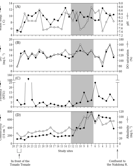
(Fig. 2). The sites close to the Tongdo Temple (i.e.
YS27 and 26) showed relatively well preserved conditions, while the urbanized reach showed degraded characteristics. Among the water quali- ty parameters, conductivity and alkalinity were the most dynamic parameters varied longitudi- nally. They had a slight and gradual increase pro- gressing downstream and a sharp increase was detected in the downtown segment. The lowest values of the two parameters were detected at the temple area, and the lower part of the stream (i.e. YS01 to YS06) exhibited increased level of
conductivity and alkalinity.
Fig. 3. illustrates the variation of HIS results and land coverage data at the study sites. The HIS scores varied along with the main channel, and the headwater area showed the highest scores in the stream (Fig. 3A). The area where the Yang- san Stream flows through the downtown area of the Yangsan City exhibited mostly degraded char- acteristics.
Land coverage showed clear and distinct differ- ence between headwater, middle and lower reach of the stream (Fig. 3B). In the headwater reach
(D)Study sites
0 1 2 3 4 5 6 7 8 9 10 11 12 13 14 15 16 17 18 19 20 21 22 23 24 25 26 27 28 Conductivity (μS cm-1)
0 200 400 600 800
Alkalinity (mg L-1) 0 20 40 60 80 100 120
Confluent to the Nakdong R.
In front of the Tongdo Temple
(A)
Water temp. (�C) 4 6 8 10 12 14
pH
7.2 7.4 7.6 7.8 8.0 8.2 8.4 8.6 8.8 9.0
(B)
DO (mg L-1)
8 10 12 14 16 18 20
DO saturation (%) 60 80 100 120 140 160 180
(C)
Turbidity (NTU) 0 5 10 15 20 14025 160
Fig. 2. The variations of physicochemical characteristics along with the stream. A, water temperature and pH; B, DO con- centration and %saturation; C, turbidity; D, conductivity and alkalinity.
(i.e., YS27 and YS26), the area of forest dominat- ed the buffer circle (more than 80%). Small % dis- tribution of urbanized area at the YS27 site was due to the Tongdo Temple. Immediate after the temple boundary, agricultural land use dominat- ed the land coverage, and forest area sharply decreased. When the stream encountered the city center, urbanized land area drastically increased, up to 50 to 60%. After this area, the dominant land
coverage transited to open land type, and water area gradually expanded.
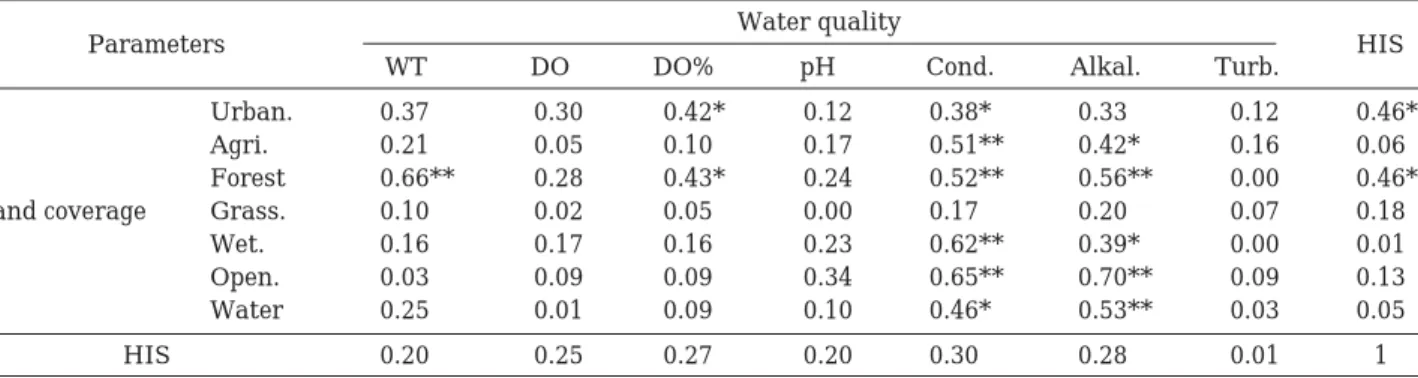
It was apparent that some parameters in three data groups (i.e. water quality, land coverage, and the HIS score) exhibited significant correla- tion (Table 2). The parameters that frequently showed significance were conductivity in water quality group, forest area in the land coverage.
Conductivity showed different relationship pat-
Fig. 3. The changes of HIS scores and land coverage patterns along with the stream. A, HIS scores obtained at each study site and the stream health level; B, land coverage changes in the stream.
Table 2. Correlation matrix for water quality, land coverage and HIS data. WT, water temperature; Cond., conductivity;
Alkal., alkalinity; Turb., turbidity; Urban., urbanized; Agri., agricultural; Grass., grassland; Wet., wetland;
Open., open land. *indicates p⁄0.05, **for p⁄0.01 at α==0.05
Parameters Water quality
WT DO DO% pH Cond. Alkal. Turb. HIS
Urban. 0.37 0.30 0.42* 0.12 0.38* 0.33 0.12 -0.46*
Agri. 0.21 0.05 0.10 -0.17 -0.51** -0.42* -0.16 -0.06 Forest -0.66** -0.28 -0.43* -0.24 -0.52** -0.56** 0.00 0.46*
Land coverage Grass. 0.10 -0.02 -0.05 0.00 -0.17 -0.20 0.07 0.18 Wet. 0.16 0.17 0.16 0.23 0.62** 0.39* 0.00 0.01 Open. 0.03 -0.09 -0.09 0.34 0.65** 0.70** 0.09 -0.13 Water 0.25 0.01 0.09 0.10 0.46* 0.53** -0.03 -0.05 HIS -0.20 -0.25 -0.27 -0.20 -0.30 -0.28 0.01 1
50 45 40 35 30 25 20 15 10 100 80 60 40 20 0
HIS% distribution
Lv. A Lv. B Lv. C Lv. D
28 27 26 25 24 23 22 21 20 19 18 17 16 15 14 13 12 11 10 9 8 7 6 5 4 3 2 1 0 Study sites
In front of the Tongdo Temple
Yangsan City
downtown area Confluent to the Nakdong R.
Water Open land Wetland Grassland Forest Agricultural Urbanized
(A)
(B)
terns, mostly as expected. Compared with land coverage, the area of urbanized, wetland, open land and water was positively related, while agri- cultural and forest area was negatively correlated.
Other water quality parameters showed some significant relationship, for example, alkalinity, water temperature, and DO %saturation.
The HIS score did not have significant relation- ship with water quality but two land coverage types such as urbanized and forest area had sig- nificance (p⁄0.05, n= =27). The other types of land coverage data neither showed significance, nor high correlation coefficients. With water quality parameters, even though no significant cases were investigated, the values of coefficients were rela- tively higher than comparison with land coverage.
The results of HIS application to Yangsan Str- eam presented current stream environments (i.e.
land use patterns and morphological characteris- tics) relatively successfully. During the field mon- itoring, the main causality of the stream environ- ments degradation was construction activity in- and outside of the stream pathway, such as bridge construction or riparian area modification (levee strengthening). This kind of activity was popular especially in the downtown area (i.e. YS12 to YS7).
The sites YS10 and YS09 were free from the con- struction, so that the index scores were over 30 (level B), but the remaining sites where levee modification (YS12 and YS11) and bridge construc- tion (YS08) occurred were determined as level C and D, respectively. Especially YS08 site was almost completely disturbed by the tentative road creation toward the center waterway for the truck entering. In contrast, the headwater area where Tongdo Temple is located was well preserved and the HIS resulted in level A. Between the two sites (i.e. YS27 and YS26), the latter site obtained high- er score, because temple buildings were located within the farthest site area (YS27). The slightly high % distribution of urbanized land coverage indicates this circumstance.
The Yangsan Stream is known as a representa- tive urbanized stream ecosystem in the Nakdong River basin. Complete monitoring from the lowest to the highest segment of the stream revealed that diverse spectrum of riparian characteristics resi- des in this stream ecosystem. As shown in previ- ous research (e.g. Park et al., 1999), the urbaniza- tion of the drainage area was the most important factor to the stream environments. The urbanized area in the land coverage encompasses industrial
as well as residential area, and this information was well reflected in the HIS scoring at the sites in the downtown reach. Correlation analysis also presented this relationship. The expansion of industrialized area in this basin was recognized as the primary factor for the stream ecosystem, including water quality deterioration (Chung et al., 1992; Kim et al., 1992), therefore, it is impor- tant to control and manage the land use pattern outside the stream pathway in order to increase stream health.
Water quality and the HIS scores for Yangsan Stream did not show significant relationships in this study. Since the sampling program took one week, most of the water quality variables exhib- ited less fluctuation, and this was the reason why no significant correlation could be obtained. In other words, the high sensitivity of the variables to the temporal scale would be the reason. For example, conductivity and alkalinity, which are not relatively sensitive to temporal scale, exhib- ited slightly higher levels of correlation. Those parameters showed a clear and significant relati- onship with land coverage, especially the expan- sion of urbanized area, which was related to the increase in conductivity. Therefore, it can be tho- ught that the utility of water quality for the rela- tionship discovery with riparian characteristics (either, land coverage or stream naturalness) wo- uld be possible when pollution-type water quality parameters were used. From National Institute of Environmental Research (2008), correlation between the HIS scores and water quality was greater in comparison with nutrients such as nit- rogen and phosphorus which were significant.
Recent developments in advanced monitoring devices (e.g. satellite imagery, telemetry, high resolution measurements) enable us to collect numerous data across a wide spectrum (Chon et al., 1996; Jeong et al., 2006). Land coverage data is one of those data types, and is popularly utilized in diffferent subject areas, such as hydrology (Poff et al., 2006), benthic invertebrates and their habi- tats (Sandin, 2009), impact on physical habitat (Pedersen, 2003), and riparian characteristics (Na- tional Institute of Environmental Research, 2008).
Distribution of biological water quality indices
(i.e. benthic algae, macroinvertebrates, etc) were
analyzed successfully with respect to land cover-
age distribution patterns (Korea Environment
Institute, 2008), which implies the utility of land
cover information for the stream modification and
habitat qualification.
The correlation between land coverage and the HIS score implies further ensemble utility of geo- graphical information and stream monitoring results, in developing explanatory models for the current status of stream characteristics. It is pos- sible to develop models using either statistical methods or machine learning algorithms (in other words, Ecological Informatics) which are flexible in model structure determination, compared with deterministic models such as differential equati- ons. Using land coverage information as input data in the model can result in the prediction of the HIS scores, and the prediction and sensitivity analysis results of the model may reveal the rela- tionship between geographical characteristics and the current stream health. The model may allow us to provide management strategy for the streams and rivers health. Furthermore, it is pos- sible to build remote sensing mechanism when the background information and relationship bet- ween geographical and national stream health data is available.
Finally, when biological information, such as quantified distribution information of bacteria, plankton, benthic diatoms, macroinvertebrates, fish, and vegetation is available, a more accurate generalization regarding ecosystem health is possible. Biological data, such as listed above are mandatory for the exact characterization of stream health which requires a description of the functi- onal and structural mechanisms within a stream ecosystem. The aforementioned environmental generalization model results can therefore be compared either with the biological information or the model can directly use the biological char- acteristics. This process can provide important and useful information for the decision makers or ecosystem scientists who are focused on increasing the effectiveness of their work in a larger scope.
ACKNOWLEDGEMENTS
The authors appreciate Mr. Maurice Lineman for his warm attention and kind effort of proof reading during the manuscript preparation pro- cess. We thank to Mr. Hyun-Bin Jo and Mr. Ji- Yoon Kim for their enthusiastic field work assis- tance during the study. This study was financially supported by the academic research funding from the Yangsan City (PNU 2009-0877-000).
LITERATURE CITED
Ahn, T.-J. 2007. The evaluation of small scaled stream naturalness for stream channel restoration. J. Kor.
Water Res. Assoc. 40: 359-369.
Chon, T.-S., Y.S. Park, K.H. Moon and E.Y. Cha. 1996.
Patternizing communities by using an artificial neural network. Ecol. Modelling 90: 69-78.
Chung, J., J.-S. Choi and C.-H. Lee. 1992. An assess- ment of water quality by epilithc diatoms of the Yangsan-Ch’on. Kor. J. Env. Biol. 10: 9-23.
Eaton, A.D., L.S. Clesceri and A.E. Greenberg. 1995.
Standard Methods for the Examination of Water and Wastewater. United Book Press, Inc., Balti- more.
Fore, L.S. and C. Grafe. 2002. Using diatoms to assess the biological condition of large rivers in Idaho (U.S.A.). Freshwater Biol. 47: 2015-2037.
Han, Y.-H., S.-K. Hong and Y.-S. Kim. 1984. Study on the water quality and the loading of pollutants in the downstream of Nakdong River. Bull. Kor.
Fish. Tech. Soc. 20: 72-78.
Jeong, K.-S., G.-J. Joo, D.-K. Kim, M. Lineman, S.-H.
Kim, I. Jang, S.-J. Hwang, J.-H. Kim, J.-K. Lee and M.-S. Byeon. 2008. Development of habitat- riparian quality indexing system as a tool of stream health assessment: case study in the Nakdong River. Kor. J. Limnol. 41: 499-511.
Jeong, K.-S., D.-K. Kim and G.-J. Joo. 2006. River phytoplankton prediction model by Artificial Neu- ral Network: Model performance and selection of input variables to predict time-series phytoplank- ton proliferations in a regulated river system. Ecol.
Inform. 1: 235-245.
Kim, D.-C., Y.-S. Yoon and I.-S. Park. 2003. An eval- uation of stream naturalness for close-to-nature stream restoration in case of Hakui Stream. J. Kor.
Soc. Ind. Appl. 6: 315-324.
Kim, M.-K., J.-W. Kim and H.-Y. Lee. 1992. A study on the communities of periphytic diatoms in Yang- san Stream. Kor. J. Limnol. 25: 9-19.
Korea Environment Institute. 2008. A Small Stream Management Plan to Protect the Aquatic Ecosys- tem, Seoul.
Lammert, M. and J.D. Allan. 1999. Assessing biotic integrity of streams: effects of scale in measuring the influence of land use/cover and habitat struc- ture on fish and macroinvertebrates. Env. Manage.
23: 257-270.
Lee, C.-S. and J.-U. Kim. 1999. A study on the distri- bution of underground plant biomass and its effect on the stream bank stability. J. Kor. Soc. Rural Plan. 5: 95-103.
National Institute of Environmental Research. 2008.
Survey and Evaluation of Aquatic Ecosystem Heal- th: the Nakdong River Basin, National Institute of Environmental Research, Incheon.
Pan, Y., R. Jan Stevenson, B.H. Hill, P.R. Kaufmann and A.T. Herlihy. 1999. Spatial patterns and ecol- ogical determinants of benthic algal assemblages in Mid-Atlantic streams, USA. J. Phycol. 35: 460- 468.
Park, B.-J., Y.-D. Sung and K.-S. Jung. 2006. A corre- lation analysis of the river naturalness and water quality for biological habitat evaluation. J. Kor.
Water Res. Assoc. 39: 637-644.
Park, S.-B., J.-Y. Lee, M.-H. Jang, H.-W. Kim, J.-M.
Jeong, J.-W. Kim and G.-J. Joo. 1999. Water qual- ity and phytoplankton community dynamics in a weir reach of the Yangsan Stream (1993-1996). Kor.
J. Limnol. 32: 331-340.
Pedersen, M.L. 2003. Physical habitat structure in lowland streams and effects of disturbance, Uni- versity of Copenhagen, Silkeborg.
Poff, N.L., B.P. Bledsoe and C.O. Cuhaciyan. 2006.
Hydrologic variation with land use across the con- tiguous United States: Geomorphic and ecological consequences for stream ecosystems. Geomorpho- logy 79: 264-285.
Sandin, L. 2009. The effects of catchment land-use, near-stream vegetation, and river hydromorphology on benthic macroinvertebrate communities in a south-Swedish catchment. Fund. Appl. Limnol.
174: 75-87.
Sutherland, A.B., J.L. Meyer and E.P. Gardiner.
2002. Effects of land cover on sediment regime and fish assemblage structure in four southern Appalachian streams. Freshwater Biol. 47: 1791- 1805.
(Manuscript received 1 November 2009, Revision accepted 8 December 2009)