Ecological Urban Planning and Design:
An Application to Hai Phong City, Vietnam
생태적 도시 계획과 설계: 베트남 하이퐁시에의 적용
Lee, Dong Kun
*Im, Seung Bin
**Ahn, Tong Mahn
**이 동 근 임 승 빈 안 동 만
Choe, Young Chan
**Lee, Seoung Woo
**Kim, Eui June
**최 영 찬
이 성 우 김 의 준
━━━━━━━━━━━━━━━━━━━━━━━━━━━━━━━━━━━━━━━━━━━
요 약
사회적·경제적·환경적 영향에 대한 장기적인 고려 없이 진행된 개발도상국가의 도시화와 인구증가는 도시의 슬럼화 등 다양한 문제를 초래하고 있다. 본 연구는 베트남 하이퐁시를 대상으로 생태적 도시계획모델을 제시하는 것을 목표 로 한다. 본 연구에서 적용한 생태적 계획과정은 크게 네 단계로 구분할 수 있다. 첫째, 기존에 연구된 생태적 도시계 획 과정 및 절차를 검토, 정리하였다. 둘째, 한국을 포함한 성공적 사례를 검토함으로써 베트남에 적용 가능한 전략과 친환경적 개발 요소 등을 도출하였다. 베트남과 비슷한 경제발전 과정을 거친 한국의 일산, 분당 등 생태도시 사례로 부터 네 가지 전략을 도출하였다. 셋째, 대상지 분석 및 토지적합성평가를 실시하였으며 절대보전, 상대보전, 개발가 능 지역 등을 도출하였다. 마지막으로 앞의 세 단계를 토대로 생태적 신도시건설을 위한 토지이용계획을 수립하였고, 블루네트워크(수체계), 그린네트워크(녹지체계), 화이트네트워크(바람길체계), 휴먼네트워크(자전거 및 보행도로체 계), 문화네트워크(역사자원체계)의 다섯 가지 네트워크개념을 적용하였다. 각 네트워크별, 각 네트워크간의 연결 및 순환을 강조함으로써 현존하는 자연적·문화적 자원을 보전, 신도시의 가치로 창출되게 하고자 하였다.
━━━━━━━━━━━━━━━━━━━━━━━━━━━━━━━━━━━━━━━━━━━━
Keywords : Ecological Urban Planning Model, Land Use Planning, Network, Vietnam 키워드: 생태적 도시계획모델, 토지이용계획, 네트워크, 베트남
━━━━━━━━━━━━━━━━━━━━━━━━━━━━━━━━━━━━━━━━━━━━
* Corresponding author, Prof., Seoul National University ([email protected])
** Prof., Seoul National University
· Co-authors : Won Kyong Song, Jae Uk Kim, Eun Young Kim, Goan Yong Lee, Hag Young Heo, Yong Sun Shin, Eun Joo Yoon, Soo Yeon Nam, Seok Lim(Graduate School, SNU)
· 본 논문은 세계은행(World Bank) 지원 연구비로 2006년 수행 한 연구의 일부임.
1. Introduction
The general context within which the study has been undertaken is a process of rapid urbanization which can be seen in most of the countries of East Asia that are not urbanized yet. Without precedent and as yet not fully in view or understood by the responsible national and local authorities, this urbanization process is creating a series of major problems concerning environmental impacts, provision of infrastructure and medium-term sustainability. Whilst some redevelopment
of the existing urban fabric is taking place, the major thrust of present urbanization is, rather, in the form of scattered developments in suburban and peri-urban areas. These make very poor use of land, fragmenting land use such that much of this becomes underused and degraded in a process of land speculation, awaiting infill development and producing further diseconomies that include traffic congestion, environmental pollution and other negative externalities. These areas initially lack urban services and are indeed difficult and expensive eventually to service due to the random and unplanned nature of the developments.
Many cities in Vietnam are suffering from this process and steps are starting to be taken, initiated by national, provincial and local governments and with the assistance of international agencies, notably the World Bank, to ameliorate the situation. Essentially, it is necessary to devise appropriate forms of urban planning and development and thence to introduce effective mechanisms to implement such plans. An overriding concern here is that the plans result in ecologically
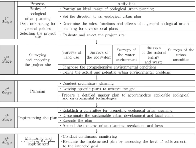
1st Stage
Process Activities
Basics of ecological urban planning
ㆍPortray an ideal image of ecological urban planning ㆍSet the direction to an ecological urban plan Decision-making for
general policies
ㆍDetermine the roles, functions and effects of a general ecological urban planning for diverse local plans
Selecting the project
site ㆍEvaluate and select the project site
↓
2nd Stage
Surveying and analyzing the project site
Surveys of land use
Surveys of the ecosystem
Surveys of the water environment
Surveys of the natural
energy and waste
Surveys of the urban amenities ㆍDiagnose the comprehensive environmental conditions
ㆍDefine the actual and potential urban environmental problems
↓
3rd
Stage Planning
ㆍConduct preliminary planning
ㆍDevelop specific plans to achieve the goal
ㆍPrepare a detailed master plan to accommodate applicable ecological and environmental technologies
↓
4th
Stage Implementing the plan
ㆍEstablish a committee for promoting ecological urban planning ㆍDisseminate the sustainable urban development and local plans ㆍExecute the plan
ㆍAmend the existing urban planning regulations and laws
↓
Table 1. Ecological urban planning process sound and sustainable development (ESSD) and
appropriate tools need to be developed to ensure that this does occur in reality.
Therefore, the specific objectives of the study documented in this paper are twofold. Firstly, it aims to develop a planning process and options for ecologically sustainable urban development models of Vietnam.
Secondly, it aims to apply a planning process of ecological urban design to the Road 353 new urban development area in Hai Phong, Vietnam.
2. Methods
The bulk of this study is concerned to present the application of the method in a particular location. This comprises an extensive area south of the city of Hai Phong known as the Road 353 Corridor. This study proposes the development of several residential areas together with industrial and business areas within a total area of 4,577.82ha and presents plans to accommodate this development.
2.1 The Study Process
To achieve the objectives, this study was carried out incorporating the following four steps. Firstly, comprehe
nsive reviews on the planning process of the eco-friendly urban design and comparative analysis were undertaken(Table 1). Secondly, diverse case studies on successful eco-friendly urban design precedents in foreign countries including Korea were reviewed. Thirdly, Based on the lessons from the literature review and case studies, site analyses and land suitability analysis on the Road 353 Corridor were conducted. Finally, based on the empirical findings a comparative analysis on the suggested land use planning for the development of the study area was carried out.
3. Results
3.1 Lessons From Case Studies
The examination of the experiences in Korea provided diverse suggestions for the construction of an environmentally sustainable urban area south of Hai Phong.
The study derives the following lessons from the case studies.
1. Upgrading the basic tertiary infrastructure and other services in low-income areas through partnerships
between communities and local governments
2. Providing and/or rehabilitating primary and secondary infrastructure networks to connect with the tertiary infrastructure in low-income areas
3. Providing affordable housing and serviced plots for low-income families that have to be resettled as a result of upgrading for the sustainable residential development of the project site
4. economic sustainability has to be one of the concerns to consider in order to prevent the project site from becoming a dormitory suburb
It was also found that direct lessons on the modal form of ecological design options can be learned from practices in other countries that were also studied.
Thus this study draws on good examples from cities in England, Germany, France and Brazil where insights can be taken into account for the purpose of designing ecologically sustainable alternatives for the study area.
3.2 Study Analysis and Land Suitability Assessment 1) Site Analysis
Figure 1. Study area
Hai Phong is a coastal city located in the northeastern part of Vietnam. Most of the area is relatively flat lowland (less than 20 meters above sea level) with an abundance of waterways. The municipal boundaries are widely drawn such that agricultural land currently predominates. The residential areas are concentrated in the relatively restricted area of Commune 7. Hai Phong is the most important port in northern Vietnam providing convenient access to both domestic and overseas destinations(Figure 1).
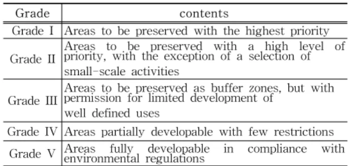
Grade contents
Grade I Areas to be preserved with the highest priority Grade II
Areas to be preserved with a high level of priority, with the exception of a selection of small-scale activities
Grade III
Areas to be preserved as buffer zones, but with permission for limited development of
well defined uses
Grade IV Areas partially developable with few restrictions Grade V Areas fully developable in compliance with
environmental regulations
Table 2. Land suitability assessment
The total land area reserved for industrial developments is 4,500 ha, including 19 industrial zones. Important functions in the area are mostly water-related economic activities including sea transport, aquaculture, tourism and recreation.
Figure 2.
Mangrove forest
Figure 3.
Vong Hai Hamlet
Figure 4.
The Road 353
Figure 5.
Cultivated land
2) Land Suitability Assessment
Based on the site analysis such as relative elevation, slope, water, wetlands, forest, etc., the study assessed the environmental values of the area employing the GIS(Geographic Information System) and RS(Remote Sensing) techniques. The computed result of the environmental significance was classified into five grades(Table 2).
The result shows that 32.19% of the study area, including the coastal zones, riparian areas and areas along other waterways may be classified as Grade I.
22.18% of the study area may be classified as Grade II, with 11.8% as Grade III, 16.61% as Grade IV, and 17.21% as Grade V. Based on these analyses land use planning was produced for the study area.
3.3 Ecological Urban Design
Land use planning of this study represents ‘an environmentally pro-active design option’ based on the results of the site analysis and Land Suitability Assessment that was carried out.
1) Development Concept; five networks
An ecological urban design is a multi-disciplinary process that functionally shapes and interconnects the inhabiting elements in order to meet the perceived needs of the community. From this functional perspective, a city is a community of complex
‘networks’ of interacting elements. Therefore, an effective ecological urban planning should focus on the
‘networks,’ rather than a single element or function among them.
Land use planning is conceptualized and structured based on the five main networks of the Blue Network;
Green Network; White Network; Human Network; and Cultural Network(Table 3).
Network contents
Blue
Network Connectivity between water bodies Green
Network
Connectivity between forests and vegetated areas
White
Network Connectivity of urban airflow channels Human
Network Connectivity of pedestrian and bicycle corridors Cultural
Network Connectivity between the cultural resources Table 3. Five Networks
Land use planning creates new values and preserves the existing natural and cultural heritages at the same time by emphasizing the circulation and connection of the networks. For example, new tourism resources and resting places are created through the connection of the Green and Cultural Network while the Human Network supports it.
-Blue Network
The Blue Network is planned based on the current coastline and river networks, and without intentionally altering the existing watercourses in principle. However, the fragmented water bodies from the main body of the Blue Network need to be connected along the green tracts and the Green Network in order to ensure higher
environment preservation, each water body is classified to form a hierarchy based on their functional properties.
For instance, while the highest design priority, concerning existing irrigation channels, should be given to the preservation of its ecologically-sound functions, these irrigation channels are concurrently designed to have recreational functions. On the other hand, the confluence points, where streams join together, certainly carry a higher level of preservation priority. Extensive riparian buffer spaces with a minimum width of 50 meters are planned around the confluence points. Some detours of existing road segments are required for this plan. And wetlands are preserved as vital habitat for many aquatic species and as ecological education resources(Figure 7).
Figure 6. Blue Network of study area
Figure 7. Aquatic biotope, or wetlands, as an ecological education venue
-Green Network
A green axis (backbone) can be shaped by linking the mangrove forests distributed along the Lach Tray River and coastline to the natural forests on the South.
The Green Network forms alongside the major rivers on the Blue Network. Riparian green areas of sufficient widths are planned to ensure the ecological connectivity with the existing watercourses maintained. The ecosystems with rich biodiversity are enclosed by buffer zones, and will be preserved as an ecological core area(Figure 8).
Where those greenways intersect are urban parks allocated in order to create a close spatial proximity to the Green Network while those greenways provide a more convenient access to the urban parks. A large central park is planned so that it can serve important functions as a recreational space and habitats for various wildlife species.
Figure 8. Green Network of study area
Figure 9. Greenway proposed alongside an urban transit railway
-White Network
Since the dominant direction of wind is practically in parallel with the alignment of the planned Blue Network and Green Network, the airflow channels in the White Network can be planned alongside the urban watercourses and green axes(Figure 10). The airflow sub-channels are also planned through the major roads so that they can actively mitigate the adverse urban microclimatic events such as the urban heat island effect and convective mixing. In principle, the White Network is planned to channel airflows taking into account the prevailing wind directions and development layouts including the urban centers(Figure 11).
However, this principle does not apply to industrial areas since it prevents the dispersion of pollutant emissions.
Figure 10. White network of study area
Figure 11. Cross section of a wind channel
-Human Network
A bicycle trail that circles around the entire site, and a convenient pedestrian access within or through the community are planned for the project(Figure 12).
Those pedestrian trails and bicycle lanes are basically planned alongside the greenways. These trails and lanes are planned to provide the residents with a safe and convenient access to public facilities, urban parks, and businesses in the community. And vest pocket parks and pocket areas are planned between the pedestrian side walks and residential area in order to create a comfortable neighborhood common space(Figure 13).
Figure 12. Human network of study area
Figure 13. bicycle lane and pedestrian road
Bicycle and pedestrian trails are to be separated from the road system and given their own right-of-way. To be specific, pedestrian trails are planned to provide a safe and convenient access between, through, and
within all neighborhoods and districts in the project site.
-Cultural Network
The cultural and historic properties need to be organically interconnected and utilized as an important resource that represents the unique local characteristics.
It is recommendable to develop the cultural attractions by grouping the scattered cultural properties(Figure 14).
Figure 14. Cultural network of study area
Each individual cultural property is to be managed and protected along with the existing green areas in the neighborhood. The perimeters of the cultural properties are to be developed as multi-functional urban parks(Figure 15). A multiple number of cultural properties can be functionally grouped to create a tourist attraction of the study area.
Figure 15. Protective buffer zone and park around a cultural or historic property
2) Land use planning
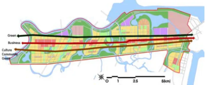
Basic directions of the land use planning can be summarized as conservation, functionality, accessibility, efficiency, amenities, and flexibility. And the project site is planned to have three thematic regional variations (mixed business area; historic and cultural area; and recreational area) while taking into account various factors including the existing major land use status and environmental conditions. Since the project area is in a long narrow strip, three main axes (green axis;
Figure 16. Axes of the land use planning
-Road Network
The road network in the project area is planned based on the existing arterial roads including Road 353(Figure 4). Each existing road provides access within the study area while a highway and railroads connect to other urban centers in the City of Hai Phong and to other regions in Vietnam. Since green strips are planned along the road network, it is necessary to construct fauna tunnels underneath the road pavements in order to allow the movement of the fauna species between these green strips.
-Industrial Area
The industrial areas are designated with the locations of the existing industrial areas considered. Green screen/buffer zones are to be created around the industrial areas, while the prevailing directions of wind considered, in order to screen the emissions. Screen planting should be incorporated into the perimeter of the major structures and facilities where these elements have a visual impact on the external areas within the site.
-Residential Area
The residential areas are to be located based upon a number of factors including the distance to employment centers, accessibility and proximity to public services, availability of services and educational facilities, and harmony with adjacent land uses. Bicycle lanes and pedestrian sidewalks are planned in parallel with the road in the frontage of the residential area.
The existing residential areas in the project area are located where it is highly likely to be influenced by drainage problems and flooding. The only way to reduce the damage is to relocate the flood-prone residential areas to somewhere beyond the floodplain.
Figure 17. Land use and networks plan central business district (CBD) is planned in the
gateway area of visible and accessible, ensuring people from every segment of the area can use them. Public facilities are planned to be jointly used with urban parks in order to highlight their community roles and functions. In particular, public facilities are planned along greenways to facilitate bicycle or/and pedestrian access. the study area; this is to facilitate the city’s economic activities including retails, commerce, and services.
Public facilities are to be located in a way they are highly visible and accessible, ensuring people from every segment of the area can use them. Public facilities are planned to be jointly used with urban parks in order to highlight their community roles and functions. In particular, public facilities are planned along greenways to facilitate bicycle or/and pedestrian access.
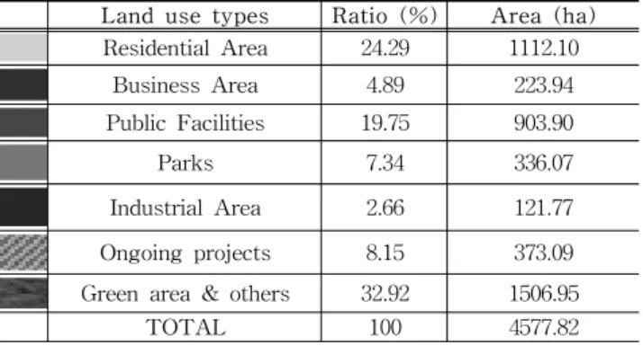
The land use configuration reflects development concept and principles above can be planned as follows(Table 4; Figure 17).
Land use types Ratio (%) Area (ha) Residential Area 24.29 1112.10
Business Area 4.89 223.94
Public Facilities 19.75 903.90
Parks 7.34 336.07
Industrial Area 2.66 121.77
Ongoing projects 8.15 373.09
Green area & others 32.92 1506.95
TOTAL 100 4577.82
Table 4. Land uses
4. Conclusion and Discussion
The study has provided ecological urban design for a specific new urban development area. The concepts, strategies, processes, and elements of ecological urban design are appropriately applied to the project site in Hai Phong City. While the local uniqueness being highlighted, the environmental, cultural and socioeconomic elements are functionally formulated within the paradigm of ecological urban design. This is intended to provide an example of how to generate ecologically and environmentally sustainable urban development with a view to reduce the problems associated with environmental degradation.
This study contains suggested process-based templates in order to facilitate the policy decision-making process toward ecologically sustainable urban planning for the City of Hai Phong. The findings of the study should provide practical and effective urban development options to local planners and policy makers of Vietnam.
It is hoped that this study influences the way that the study team and other development partners understand, design, and implement ecological urban development policies.
References
1. Barnett, J. (1982) An Introduction to Urban Design. New York: Harper & Row, Publishers.
2. BEGHTEL (1997) Hanoi New Town - Preliminary Master Plan. DAEWOO Engineering and Construction Co.
3. Citizens’ Institute for Environmental Studies (2001) Way to
Eco-city. Seoul: Doyosae.(In Korean)4. Klosterman, R.E. (1990) Community Analysis and Planning Techniques. Bollman Place. Maryland: Rowman & Littlefield Publishers, Inc.
5. Haskell, T. (ed.) (1993) Caring for our Built Heritage.
London: E. & F. N. Spon.
6. Lee, D.K., Sung, H.C., Jeon, S.W., Lee, S.D., Kim, K.G.,
Kim, J.U. (2005) "Study on the Classification of Gyeonggi-Do’s Conservation Areas by Improvement of National Land Environmental Assessment." Journal of the Korea Society for Environmental Restoration and Revegetation Technology 8(4): 43-51.(InKorean with English abstract)
7. Lee, W.S. (2005) Introduction of the National Territorial
Development Policies of Korea, Korea Research Institute for Human Settlements.(In Korean with English abstract) 8. McHarg, I. (1969) Design with Nature. New York:Doubleday/Natural History Press.
9. Ministry of Environment, Republic of Korea (1996) Project
for Creation of Ecological Urban Plan.(In Korean)10. Park, B.H. (1997) "Applications and Developments of the
Bicycle Trails." ChungBuk Development Research 8(2):195-219.(In Korean with English abstract)
11. Pruetz, R. (1997) Saved by Development: Preserving Environmental Areas, Farmland and Historic Landmarks with Transfer of Development Rights. Burbank, California, U.S.A.: Arje Press.
12. Ryn, Sim van der and S. Cowan (1996) Ecological Design.
Washington, D.C.: Island Press.
13. Shin, D.J. (2004) New Town Development Policy and Case
Studies in Seoul Metropolitan Area.(In Korean)14. Tyler, N. (2000) Historic Preservation. New York: W.W.
Norton & Company.
15. UNDP (1996) Eco-city Planning Guidance.
16. Walmsley, A. (2006) "Greenways: multiplying and diversifying in the 21st century." Landscape and Urban Planning 76: 252-290.
17. Watson, D. et al (editors) (2003) Time-Saver Standards for Urban Design. Seoul: McGraw-Hill.