금강 수계 서식지 유형분류 및 수서곤충 섭식기능군 분포특성
1박영준2ㆍ김기동2ㆍ조영호3ㆍ한용구3ㆍ김영진3ㆍ남상호3*
Habitat Classification and Distribution Characteristic of Aquatic Insect Functional Feeding Groups in the Geum River, Korea
1Young-Jun Park2, Ki-Dong Kim2,Young-Ho Cho3, Yong-Gu Han3, Yeong-Jin Kim3, Sang-Ho Nam3*
요 약
본 연구는 금강 수계의 환경요인을 이용한 서식지 유형분류와 그에 따른 수서곤충 섭식기능군의 분포특성을 규명하 기 위한 것으로 2007년부터 2008년까지 금강 수계에서 총 38개 지점에 대하여 봄과 가을에 걸쳐 년 2회씩 총 4회 조사를 실시하였다. 38개 조사지점별로 15개의 환경요인들을 현장 측정한 후 서식지 유사도 분석을 실시한 결과, 거리 척도값 4를 전후하여 상류구간(HD)은 C1과 C3그룹, 중류구간(MS)은 C2와 C4 그리고 C5그룹, 하류구간(LR)은 C6과 C7그룹으로 서식지 유형이 분류되었다. 서식지 유형분류에 있어 영향을 끼치는 주요한 환경요인은, 물리적 환경요인의 경우 하폭과 고도, 화학적 환경요인의 경우 수온과 전기전도도 그리고 DO, 하상재료의 경우 모래와 실트 그리고 잔자갈의 함량으로 분석되었다. 조사시기 동안 출현한 수서곤충은 총 9목 46과 142종으로 조사되었고, 서식지 유형별 종수 및 개체수 현존량 증감과 높은 상관성을 보인 주요 환경요인은 유속과 모래의 함량으로 나타났다. 또한 섭식기능군과 환경요인 사이의 상관성 분석결과, (1) 걸러먹는 무리(FC)는 유속, 수폭, 실트 (2) 주어먹는 무리(GC)는 유속 (3) 잡아먹는 무리(P)는 고도, 유속, 큰돌, 전기전도도, 모래 (4) 뚫어먹는 무리(PP)는 수폭, 실트 (5) 긁어먹는 무리(SC)는 유속, 전기전도도 (6) 썰어먹는 무리(SH)는 고도, 큰돌, DO, pH, 전기전도도, 수온과 각각 상관성을 보이는 것으로 나타났다. 본 연구의 결과, 단계적 다중회귀분석(SMRA)에 의해 도출된 금강 수계의 환경요인 중 고도, 하폭, 유속, 전기전도도, 수온 그리고 모래 등 6개의 요인은 생물군집의 서식과 상관성(r≧0.600, P<0.01)이 있는 것으로 나타나 금강 수계 섭식기능군 분포에 영향을 미치는 주요한 요인으로 제시되었다.
주요어: 환경요인, 유사도분석, 상관분석, 단계적 다중회귀분석
1 접수 2011년 6월 8일, 수정(1차: 2011년 9월 8일), 게재확정 2011년 9월 9일 Received 8 June 2011; Revised(1st: 8 September 2011); Accepted 9 September 2011
2 국립환경과학원 자연자원연구과 Nature Conservation Research Division of NIER, Incheon(404-708), Korea 3 대전대학교 생명과학과 Dept. of Biological Science Daejeon Univ., Daejeon(300-716), Korea
* 교신저자 Corresponding author([email protected])
ABSTRACT
This study was performed to classify habitat types depending on environmental factors and to find out distribution characteristics of functional feeding groups of aquatic insects which were collected at that habitat types. Field survey was conducted twice in a year for every spring and fall from 2007 to 2008 for 38 sites in the Geum River. During the field survey 15 environmental factors were measured at each 38 sites and analyzed by similarity analysis method to classify habitat types. The result of similarity analysis showed that the 38 sites could be grouped into 7 classes like as C1 and C3 class belong to Head water(HD), C2 and C4 and C5 class belong to Middle stream(MS), C6 and C7 class belong to Large River(LR) based on euclidean distances 4. And
also, we could extract the main environmental factors affecting the classification of habitat types such as Stream Width and Elevation of physical environmental factors, Water Temperature, Conductivity and DO of chemical environmental factors, percentages of Sand, Silt and Gravel of substrate factors. Total 142 species of aquatic insects in 46 families, 9 orders were collected during the field surveys and the occurrence number of species and individuals showed high correlation with the Velocity factor and the percentage of Sand factor of each habitat types. In addition, correlation analysis between functional feeding groups and environmental factors represented that (1) Filtering-collectors(FC) affected by Velocity, Stream Width and Silt, (2) Gathering- collector(GC) affected by Velocity, (3) Predator(P) affected by Elevation, Velocity, Boulder, Conductivity and Sand, (4) Plant-piecer(PP) affected by Water Width and Silt, (5) Scraper(SC) affected by Elevation and Conductivity, (6) Shredder(SH) affected by Elevation, Boulder, DO, pH, Conductivity and Water Temperature respectively. As a result of this study, Elevation, Stream Width, Velocity, Conductivity, Water Temperature and percentage of Sand factors which were deduced by stepwise multiple regression analysis had correlations(r≧
0.600, p<0.01) with biota community inhabitation. Therefore these six environmental factors were regarded as major environmental factors that might affect highly the distribution of functional feeding groups in stream ecosystem of the Geum River.
KEY WORDS: ENVIRONMENTAL FACTOR, SIMILARITY ANALYSIS, CORRELATION ANALYSIS, STEPWISE MULTIPLE REGRESSION ANALYSIS
서 론
하천생태계(stream ecosystem)는 지난 반세기 동안 급격 한 산업 및 도시화의 진전으로 국토개발사업이 본격화 되면 서 하천 토지이용 증대 및 개발 등으로 인해 물리⋅화학적 성질 등이 변화되었고, 그 구조와 기능에 큰 변화를 가져왔 다(Joo et al., 1997; Bae et al., 2003; Song et al., 2005).
또한 최근 4대강 살리기 사업과 하천주변 신도시개발 등 다양한 환경변화요인이 하천생태계에 지속적으로 발생되 고 있어, 그 관심이 날로 증가하고 있다. 그러나 기존 하천생 태계 평가 및 관리는 생물학적 특성을 고려하지 않은 물리 적 환경 및 이화학적 수질개선대책 위주의 관리에 의존함으 로서 하천환경 악화나 개선의 필요성과 같은 문제점들이 지속적으로 나타나게 되는 원인이 되고 있으며, 향후 계획 도 이러한 틀에서 크게 벗어나고 있지 않다(Song and Park, 2003; Hwang et al., 2006). 하천연속성 개념(River Continuum Concept, RCC)에 의해 하천생태계는 상류에서 하류로 갈수록 다양한 환경요인의 변화에 따라 환경특성이 변화되어 서식처 특징을 결정하게 되며(Vannote et al., 1980; Horne and Goldman, 1994; Allan, 1995), 그 안에 서식하는 생물군집의 구조와 기능을 결정하는 중요한 요인 으로서 영향을 미치게 된다. 하천의 효율적인 관리 및 평가 를 위해서는 하천들의 특성이 파악되어야하며, 이들 특성의 유사성과 상이점 등에 의해 비슷한 종류끼리 묶어내는 유형
화 작업이 선행되어야 한다(Song and Park, 2003). 이와 같은 생물적인 요소의 환경변화에 대한 반응은 생태계내에 기능적 구성요소인 군집의 범위 내에서 일어나는 현상이며 (Ro et al., 2006), 서식처의 공간특성을 구성하는 환경요인 은 그 안에 서식하는 생물군집의 구조와 기능을 결정하는 중요한 요인으로 직⋅간접적인 영향을 미치게 된다.
하천생태계에 영향을 미치는 주요한 환경요인은 고도, 유 속, 유량, 수심, 하상재료, 토양, 온도, 빛, 강수량과 기후 등의 물리적 요소와 pH, BOD, DO 등의 화학적 요소로 구분할 수 있으며, 생물 구성원은 크게 조류(algae)와 수변 및 수중식물 등의 생산자와 저서성 대형무척추동물과 어류 및 양서류와 같은 소비자 그리고 박테리아와 곰팡이 같은 미생물로 구성된 분해자로 구별된다(Allan, 1995). 특히, 수 서곤충은 저서성 대형무척추동물의 종 및 개체수 현존량에 서 대부분을 차지하고 있어 하천 담수동물 중에서 가장 다 양하고 풍부한 무리일 뿐만 아니라(Rosenberg and Resh, 1993), 영양단계의 저차 소비자(1차 또는 2차 소비자가 대 부분)이기 때문에 하천생태계 구성원으로서 매우 중요한 역 할을 하고 있다(Hynes, 1970; Ward, 1992; Willam and Feltmate, 1992). 또한 다양한 먹이자원의 획득방법에 따른 영양단계를 설명할 수 있는 섭식기능군(Functional feeding groups, FFGs)의 분류 제시 및 체계화하려는 일련의 연구가 시도되었고(Cummins, 1973; 1974; Cummins and Klug, 1979; Merritt and Cummins, 1984; 1996), 각 분류군 별로
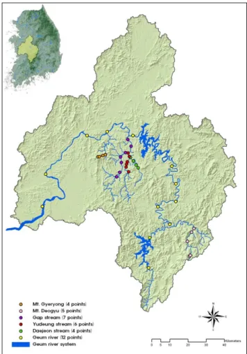
Figure 1. Location of survey sites(38 points) in the Geum River
섭식기능군의 세분화 작업을 수행한 바 있다(Wallace and Merritt, 1980; Hawkins and Sedell, 1981; Behmer and Hawkins, 1986; Bunn, 1986; Beisser et al., 1991; Growns and Davis, 1994). 국내의 경우 Merritt-Cummins(1996)의 체계를 토대로 다양한 선행 조사 및 문헌자료로 한국산 수 서곤충류 섭식기능군 유형 분류 및 생태적 중요성을 체계적 으로 정리하였으며(Ro, 2002), 수서곤충의 섭식기능군 조 성에 따른 하순 분석과 생태계 내 군집 안정성 기여도 등과 같은 분포특성을 규명하려는 연구가 다양하게 진행되고 있 다(Bae et al., 2003; Ro and Chun, 2004; Won et al., 2005;
Shin et al., 2006; Park et al., 2006; 2010).
본 연구의 대상지인 금강 수계는, 전라북도 동부지역과 충청북도 남서지역을 북서류하여 충청남도 남동지역을 지 나 황해로 흘러드는 강으로 발원지에서 구 하구까지 총 유 로연장 397.79㎞에 달하는, 남한에서 한강과 낙동강에 이어 3번째로 긴 강이다(The Ministry of Construction and Transportation, 2002). 금강 수계에 대하여 기존에 보고된 생물상 조사연구는 본류 및 일부 지천을 중심으로 현재까지 지속적인 조사연구가 수행되고 있지만(Nam et al., 1994;
2001; 2003; 2004; Park, 2004; Park et al., 2006; Jang, 2007; The Ministry of Environment, 2007; 2008), 대부분 생물상 및 생물학적 수질평가를 중심으로 이루어지고 있으 며, 하천연속성 개념을 적용한 환경요인에 따른 생물군집의 분포특성에 대한 연구는 거의 없는 실정이다.
따라서 본 연구는 하천구배에 따른 환경요인 및 생물군집 이 변화한다는 하천연속성 개념을 금강 수계에 적용하여 다양한 환경요인을 통해 나타나는 서식지 유형을 분류하고, 분류된 서식지 유형에 따른 수서곤충 섭식기능군의 구조와 기능을 분석하였다. 또한 분석된 결과와 환경요인과의 관 계를 해석함으로서 분포특성을 규명하여 하천생태계 보전 및 복원 시 효율적인 관리를 위한 기초자료로 제공하고자 한다.
재료 및 방법
1. 조사지 개황 및 조사 시기
본 연구의 대상지인 금강 수계에 현재 상태를 객관적이고 과학적으로 평가하기 위하여 공간적 규모와 범위에 따라 환경특성 차이를 보이는 하천연속성의 개념을 고려하여 (Vannote et al., 1980) 국립공원 덕유산(1,614m)에서 발원 하는 무주남대천 5개 지점과 계룡산(845m)에서 발원하는 용수천 4개 지점, 대둔산(877.7m)에서 발원하여 금강에 합 류하는 제 1지류인 갑천 7개 지점과 충청남도 금산군 진산 면 삼가리 인대산(666m)과 월봉산(543m)에서 발원하여 갑
천에 합류하는 유등천 6개 지점, 그리고 대전광역시 만인산 (537.1m)에서 발원하여 유등천에 합류하는 대전천 4개 지 점 그리고 금강 본류를 중심으로 12개 지점 등 총 38개의 다양한 조사지점을 선정하여 조사를 실시하였다(Figure 1, Appendix 1).
본 연구를 위한 조사는 2007년부터 2008년까지 금강 수 계에서 총 38개 지점에 대하여 봄(2007년 5월 6~16일, 2008년 5월 7~18일)과 가을(2007년 10월 13~22일, 2008년 10월 11~20일)에 걸쳐 년 2회씩 총 4회 수행되었다.
2. 조사방법
야외 조사 시 걸어서 건널 수 있는 하천(wadeable stream) 에서는 망목지름 0.5㎜의 계류용 정량채집망인 Surber net(30×30㎝)을 사용하여 여울(riffle)에서 정량 채집하였 고, 수심이 깊은 본류와 같은 강에서는 반구형 밑변에 톱니 모양이 달린 Dredge sampler(30×30㎝)를 이용하여 총 3회
Ranges of R Ranges of R2 Expression of correlation
0.00 - 0.20 0.00 - 0.04 few correlation
0.20 - 0.40 0.04 - 0.16 low correlation
0.40 - 0.60 0.16 - 0.36 show correlation
0.60 - 0.80 0.36 - 0.64 high correlation
0.80 - 1.00 0.64 - 1.00 very high correlation
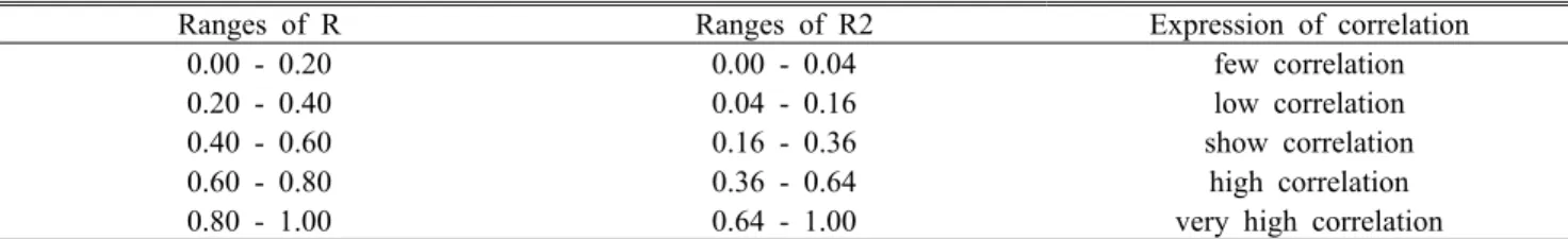
*Source: Park and Yoon(2002)
Table 1. Relation between range of correlation coefficient(R) and range of coefficient of determination(R2) 실시하였다. 채집된 표본은 대전대학교 동물분류학실에 보
관하였다. 하천생태계내 수서곤충의 서식에 영향을 미칠 수 있는 환경요인을 5개 물리적 요인(고도, 하폭, 수폭, 수심, 유속)과 4개 화학적 요인(pH, DO, 전기전도도, 수온) 그리 고 6개 하상재료(큰돌, 돌, 자갈, 잔자갈, 모래, 실트) 등 총 15개로 구분하였으며(Ward, 1992; Allan, 1995; Park, 2004; Ro et al., 2006), 종합적이고 체계적인 결과를 도출하 기 위하여 생물상 샘플링과 동시에 환경요인 측정을 수행하 였다.
생물군집의 서식에 큰 영향을 미치는 물리적 요인 중에 기압이나 온도 등 다른 환경요인과 관련되어 생물의 서식 범위를 제한하고, 수서곤충의 상류방향으로의 이동에 장 애요인(Allan, 1995)이 되는 고도의 경우는 수치지형도 (1:25,000) 및 GPS(Garmin Vista HCx)를 활용하여 추출하 였다. 일반적으로 규모가 클수록 다양한 미소서식처가 존재 할 확률이 높으며, 이에 따라 수서생물군집의 다양성과 현 존량에 영향(Negishi et al., 2002)을 미치는 하폭과 수폭은 홍수기를 고려하여 제방과 제방사이의 거리(m)와 시기별 물이 흐르는 거리(m)를 광파거리측정기(Bushnell Tour V2) 로 측정하여 평균값을 사용하였다. 조류(algae)와 같은 생산 자의 광합성에 중요한 제한인자(Horne and Goldman, 1994)인 수심과 생물마다 선호성이 다르기 때문에 분포특 성을 결정짓는 요인(Edington, 1968)임과 동시에, 먹이자원 분할에도 관여(Allan, 1995)하는 유속은 각 조사지점별로 3개 지점에 측정점을 정하여 쇠자(1m)와 유속계(Flowatch) 를 이용하여 측정한 후 평균값을 사용하였다. 또한 하천 생 물의 다양성에 큰 영향을 끼치는 중요한 요인인(Lamberti and Resh, 1979; Minshall, 1984) 하상구조는 Cummins (1962)의 하천분류체계 중 6개 하상재료를 중심으로 조사 지점내 1×1m의 방형구를 설치하여 면적에서 차지하는 구 성 비율(%)을 구분하여 나타내었다. 그리고 일반적으로 수 질오염과 관련되어 있으며, 대부분 인간의 활동에 의해 영 향을 받는 이화학적인 요인 중, 일반적인 하천에서 생물에 치명적인 영향을 미치는 경우는 드물지만 생활하수 및 공장 폐수 등의 유입에 의해 변하게 되는 pH, 대기 중 산소의 자연적 용해에 의하여 공급되고, 조류나 수생식물의 광합성
에 의하여 증가되나 동⋅식물 호흡작용이나 미생물 유기물 분해과정 등에 의해 그 양이 감소되어 부족하게 되면 수서 생물군집의 생존에 영향을 미치는 DO(㎎/ℓ), 공업용수 및 공장폐수의 관리에 주로 이용되는 전기전도도(S), 생물의 생장과 더불어 하천 자정작용에 영향을 미치는 수온(℃) 등 4가지 요인을(Choi et al., 1995; Chun, 2004; Park, 2004;
Ro et al., 2006) 조사시기별로 현장에서 다항목 수질측정기 (PCD 650)를 이용하여 측정하고 그 평균값을 사용하였다 (Appendix 2).
3. 분석방법
환경요인과 조사지점을 이용하여 계층적 클러스터 방법 (Agglomerative Hierarchical Clustering, AHC)중 유클리 드 거리척도(euclidean distances)를 이용한 평균연결법중 비 가중 평균법(Unweighted Pair Group Method with Arithmetic mean, UPGMA)의 유사도분석을 통하여 서식 지 유형을 분류하였다. 또한 서식지 유형분류에 영향을 미 친 중요한 환경요인을 알아보기 위해서 단계적 다중회귀분 석법(Stepwise Multiple Regression Analysis, SMRA)을 사 용하였고, 분류된 그룹과 환경요인과의 유의성 검정은 집단 의 분포가 정규분포를 하지 않으므로 비모수적 통계방법 중 Kruskal-Wallis test를 이용하여 검정하였다. 그리고 섭 식기능군 분류는 문헌(Cummins, 1973; 1974; Cummins and Klug, 1979; Merritt and Cummins, 1996; Ro, 2002;
Won et al., 2005)을 사용하였으며, 분류된 섭식기능군과 환경요인에 관한 상관분석(Park and Yoon, 2002)을 실시하 여 생물군집의 구조 및 기능에 영향을 미치는 환경요인을 분석하였다(Table 1). 기타 고도 및 하천 총 길이 등의 지형 적 환경정보는 1/25,000 지형도를 바탕으로 ArcGIS ver9.3 을 통하여 분석하였고, 통계분석은 SPSS ver. 12K를 이용 하였다.
결과 및 고찰
1. 서식지 유형분류
Class 1 2 3 4 5 6 7
1 0
2 5.110 0
3 3.377 4.010 0
4 7.070 3.160 5.697 0
5 7.986 4.201 6.792 2.759 0
6 9.245 6.157 7.925 4.889 4.156 0
7 11.986 9.206 10.754 7.594 7.477 4.656 0
Table 2. Distances between the class centroid
Figure 2. Clustering of sites based on environmental factors 본 연구에서는 서식지 유형분류를 위해 금강 수계 38지
점에 대하여 수서곤충의 서식에 영향을 미치는 것으로 알려 진 물리적 및 화학적 환경요인과 하상재료 중 현장 측정한 15개의 요인을 사용하여 분석 한 결과(Appendix 2), 유사도 거리 척도값 약 5를 전후하여 주성분분석의 공간배열과 같 이 3개의 그룹(Headwater; Medium-stream; Large river)으 로 구분되었으며(Vannote et al., 1980), 거리 척도값 4를 전후하여 상류구간(HD)의 경우 C1과 C3그룹, 중류구간 (MS) C2와 C4 그리고 C5그룹, 하류구간(LR) C6과 C7그 룹으로 서식지 유형이 분류되었다(Figure 2, Table 2). 7개 서식지 유형별 환경요인들의 차이를 비교해 보기 위하여 유의성 검정을 실시한 결과(by Kruskal-Wallis test), 7개 그룹의 15개 환경요인은 모두 유의한 차이가 있는 것으로 나타났다(Appendix 4).
서식지 유형분류에 주요한 영향을 미치는 요인을 파악하기 위해 단계적 다중회귀분석을 실시한 결과, 물리적 환경요인의 경우 하폭(x1)과 고도(x2)에 의해 영향을 많이 받는 것으로
분석되었으며(Y=3.810+0.004x1-0.002x2, r2=0.558, p<0.01), 그 중에서도 미소서식지의 다양성을 결정하는 하폭에 의한 영향이 큰 것으로 나타났다(Negishi et al., 2002; Park, 2004;
Ro et al., 2006). 화학적 환경요인의 경우 수온(x1)과 Conductivity(x2) 그리고 DO(x3)에 의해 영향을 받는 것 으로 분석되었으며(Y=2.905+0.117x1+0.006x2+0.274x3, r2=0.754, p<0.01), 그 중에서도 생물의 성장과 하천의 자정 작용에 영향을 미치는 수온의 영향이 큰 것으로 나타났다 (Choi et al., 1995; Chun, 2004). 또한, 많은 수서생물 중 저서성 대형무척추동물에 있어서 서식처로서의 중요한 기 능을 하는 하상재료(Lamberti and Resh, 1979; Minshall, 1984)의 경우 모래(x1)와 실트(x2) 그리고 잔자갈(x3)에 의 해 영향을 받는 것으로 분석되었으며(Y=1.700+0.46x1+
0.067x2+0.039x3, r2=0.720, p<0.01), 그 중에서도 모래의 영향이 큰 것으로 조사되었다. 도출된 서식지 유형분류에 많은 영향을 미치는 주요한 환경요인은 일반적인 하천의 특징인 상류에서 하류로 갈수록 고도가 낮아지고, 하천의
Figure 3. Comparison of relative ratio species(a) and individuals(b) of functional feeding groups in the Geum River 규모가 커지므로 하천폭이 넓어지고, 유량이 증가하는 특성
을 반영하고 있다. 또한 수심이 깊어지며, 수변식생의 감소 로 인하여 일조량이 많아져 수온이 증가하게 되고 모래가 주를 이루게 되는 일반적인 하천특성(Vannote et al., 1980;
Park, 2004)을 잘 반영한 요인으로 판단된다.
2. 섭식기능군 분포특성
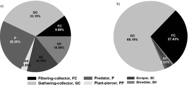
금강 수계 전 조사지점 출현한 수서곤충은 총 9목 46과 142종 105,755.6개체로 조사되었으며, 섭식기능군 종 구성 및 개체수 현존량을 살펴보면 주워먹는 무리(Gathering- collector, GC)가 47종 33.10%로 가장 높게 나타났다. 그 다음 잡아먹는 무리(Predator, P) 36종 25.35%, 긁어먹는 무리(Scraper, SC) 21종 14.79%, 썰어먹는 무리(Shredder, SH) 20종 14.08%, 걸러먹는 무리(Filtering-collector, FC) 14종 9.86% 그리고 뚫어먹는 무리(Plant-piercer, PP) 4종 2.82% 순으로 조사되었다. 개체수 현존량의 경우 주워먹는 무리가 72,078.7개체 68.16%로 대부분을 차지하고 있는 것 으로 나타났으며, 그 다음으로 걸러먹는 무리 29,012.3개체 27.43%, 긁어먹는 무리 2,457.3개체 2.32%, 잡아먹는 무리 1,327.3개체 1.26%, 썰어먹는 무리 818.7개체 0.77%, 그리 고 뚫어먹는 무리 61.3개체 0.06%의 순으로 조사되었다 (Figure 3, Appendix 5).
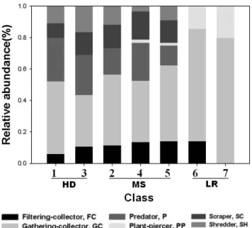
서식지 유형별 섭식기능군의 종 구성과 개체수 현존량 특성을 비교한 결과(by Kruskal-Wallis test), 종 구성에서 뚫어먹는 무리를 제외하고는 모두 통계적으로 유의한 차이 를 보였다(Appendix 5). 걸러먹는 무리의 경우 종수와 개체 수 현존량 모두 중류구간이 다른 서식지 유형보다 상대적으
로 더 높게 출현하였고, 주워먹는 무리의 경우 상⋅중⋅하 류구간에 고루 분포하고 있었으며(Ro et al., 2006), 하류구 간으로 갈수록 비율이 증가하는 것으로 조사되었다(Figure 4). 대부분의 주워먹는 무리에 경우 깔따구류나 등줄하루살 이와 같은 오염에 내성이 강한 종들이 포함되어 있기 때문 에 하류로 갈수록 점유율이 증가하는 경향성을 보이고 있는 것으로 판단되며(Bae et al., 2003; Park et al., 2006; Shin et al., 2006), 하류구간으로 갈수록 인간에 의한 교란과 유 기물질(Organic matter)의 증가 등 인위적인 요인이 관련되 어 있기 때문으로 사료된다(Hu et al., 2005; Qu et al., 2007). 잡아먹는 무리의 경우 종수와 개체수 현존량 모두 상류구간이 다른 서식지 유형에 비해 상대적으로 더 높은 출현비율을 보였다. 이것은 잡아먹는 무리가 섭식기능군에 절반인 약 48%의 높은 비율을 차지하고 있고, 상류수계에 주로 출현한 전체 잠자리목과 일부 강도래목이 육식성 포식 자 기능군에 속해 있기 때문으로 판단된다(Ro, 2002). 뚫어 먹는 무리는 잡아먹는 무리와 반대로 하류구간이 상⋅중류 구간에 비해 더 높은 출현을 나타냈다. 하천이 연중 햇빛에 개방된 상태인 중류구간 이상에서 점유율이 증가하는 경향 을 보이는 긁어먹는 무리의 경우 종수와 개체수 현존량 모 두 상⋅중류구간에 고루 분포하고 있었으며, 하류에는 출현 하지 않았다(Park et al., 2006). 그리고 썰어먹는 무리의 경우 상류수계에 많은 종수와 개체수 현존량이 존재하며, 일반적으로 하천의 크기가 증가할수록 감소하는 경향성을 보이게 되는데(Vannote et al., 1980; Hawkins and Sedell, 1981; Park et al., 2006; 2010; Ro et al., 2006; Shin et al., 2006), 이번 조사에서도 종수와 개체수 현존량 모두 상 류구간에서 다른 서식지 유형들에 비해 더 높은 출현 비율
Figure 4. Comparison about relative abundance of species functional feeding groups by classes in the Geum River
Environmental factors
Statistics
CCNSa CCNIb
r P-value r P-value Elevation (m) 0.386* 0.017 -0.132 0.428 Stream width (m) -0.590** 0.000 -0.257 0.120 Water width (m) -0.581** 0.000 -0.288 0.080 Water depth (m) -0.554** 0.000 -0.237 0.151 Velocity (㎧) 0.734** 0.000 0.389* 0.016 Boulder (%) 0.297 0.070 -0.228 0.169 Cobble (%) 0.514** 0.001 0.059 0.723 Pebble (%) 0.494** 0.002 0.241 0.146 Gravel (%) 0.096 0.568 0.343* 0.035 Sand (%) -0.640** 0.000 -0.201 0.226 Silt (%) -0.554** 0.000 -0.268 0.103 pH (pH) -0.317 0.052 0.168 0.313 DO (㎎/ℓ) -0.358* 0.027 -0.079 0.637 Conductivity (S) -0.587** 0.000 0.051 0.761 Temperature (℃) -0.308 0.060 0.291 0.077
*P<0.05; **P<0.01 in the Pearson correlation analysis a: Correlation coefficients for the number of species, b: Correlation coefficients for the number of individuals Table 3. Correlation coefficients between environmental
factors and number of species and individuals
을 나타냈다. 이러한 결과를 통해 볼 때 금강 수계의 상류구 간은 썰어먹는 무리와 잡아먹는 무리의 비율이 높았고, 중 류구간은 긁어먹는 무리의 비율이 증가하는 것을 볼 수 있 었다. 그리고 하류구간은 뚫어먹는 무리가 상대적으로 높은 점유율을 보였다. 또한 상⋅중류구간은 주워먹는 무리 및 걸러먹는 무리인 collector가 증가하는 것을 확인 할 수 있었 다. 결과적으로 본 연구지역인 금강 수계에서는 하천연속성 의 개념에서 소개된 부분과 많은 부분이 일치하고 있어 그 적용이 대체로 무난한 것으로 사료된다(Vannote et al., 1980; Ward, 1992; Williams and Feltmate, 1992; Allan, 1995; Bae et al., 2003; Park et al., 2010).
3. 상관관계 분석
섭식기능군의 종 구성 및 개체수 현존량에 영향을 미치는 주요한 환경요인을 파악하기 위해 상관관계 분석(by pearson correlation analysis)을 실시하여 상관관계의 정도 를 파악해 본 결과(Table 1), 서식지 유형별 종수 및 개체수 현존량 증감에 영향을 미치는 환경요인으로는 유속 (r=0.734, P<0.01)과 모래(r=-0.640, P<0.01)가 높은 상관성 을 보이는 요인으로 나타났으며(Edington, 1968; Allan, 1995), 그 외에도 하폭, 수폭, 수심, 실트, 전기전도도 그리 고 돌이 상관성을 보이는 것으로 조사되었다. 개체수 현존 량은 유속(r=0.389, P<0.05)과 잔자갈(r=0.343, P<0.05)이 낮은 상관성을 보여 큰 영향은 미치지 않는 것으로 분석되
었다(Table 3).
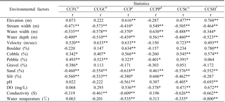
그리고 섭식기능군별로 살펴보면 걸러먹는 무리의 경우 유속(r=0.520, P<0.01)과 수폭(r=-0.535, P<0.01) 및 실트 (r=-0.560, P<0.01)가 상관성을 나타났다. 주어먹는 무리는 유속(r=0.633, P<0.01)과 높은 상관성을 나타냈으며, 잡아 먹는 무리는 고도(r=0.616, P<0.01)와 유속(r=0.633, P<0.01)과 큰돌(r=0.634, P<0.01) 그리고 전기전도도 (r=-0.609, P<0.01)와 모래(r=-0.618, P<0.01)가 높은 상관 성을 보이는 것으로 조사되었다. 뚫어먹는 무리의 경우 수 폭(r=0.630, P<0.01)과 실트(r=0.606, P<0.01)가 높은 상관 성을 나타냈으며, 긁어먹는 무리의 경우 유속(r=0.723, P<0.01)과 전기전도도(r=-0.626, P<0.01)가 높은 상관성을 보이는 것으로 조사되었다. 썰어먹는 무리의 경우 고도 (r=0.768, P<0.01)와 큰돌(r=0.780, P<0.01)과 DO(r=0.672, P<0.01) 그리고 pH(r=-0.693, P<0.01)와 전기전도도 (r=-0.662, P<0.01)가 높은 상관성을 보였으며, 수온의 경우 (r=-0.800, P<0.01) 매우 높은 음의 상관성을 나타내는 것으 로 조사되었다(Table 4).
결과적으로 단계적 다중회귀분석에 의해 도출된 환경인 자 중 생물군집의 서식과 상관성(r≧0.600, P<0.01)이 있는 고도, 하폭, 유속, 전기전도도, 수온 그리고 모래 등 6개의 환경요인은 금강 수계 섭식기능군 분포에 영향을 미치는 주요한 요인으로 분석되었다(Park, 2004; Ro et al., 2006).
Environmental factors
Statistics
CCFCa CCGCb CCPc CCPPd CCSCe CCSHf
r r r r r r
Elevation (m) 0.073 0.222 0.616** -0.287 0.477** 0.768**
Stream width (m) -0.471** -0.573** -0.410* 0.549** -0.505** -0.464**
Water width (m) -0.535** -0.578** -0.370* 0.630** -0.488** -0.344*
Water depth (m) -0.409* -0.510** -0.439** 0.561** -0.460** -0.523**
Velocity (m/sec) 0.520** 0.633** 0.633** -0.150 0.723** 0.493**
Boulder (%) -0.220 0.147 0.634** -0.157 0.234 0.780**
Cobble (%) 0.342* 0.407* 0.566** -0.260 0.545** 0.574**
Pebble (%) 0.493** 0.523** 0.323* -0.401* 0.391* 0.064
Gravel (%) 0.386* 0.113 -0.171 -0.303 0.051 -0.172
Sand (%) -0.460** -0.554** -0.618** 0.461** -0.576** -0.552**
Silt (%) -0.560** -0.533** -0.380* 0.606** -0.462** -0.287
pH 0.022 -0.222 -0.561** 0.307 -0.405* -0.693**
DO (mg/L) 0.068 0.293 0.536** -0.378* 0.471** 0.672**
Conductivity (S) -0.319 -0.461** -0.609** 0.196 -0.626** -0.662**
Water temperature (℃) 0.063 -0.201 -0.535** 0.313 -0.335* -0.800**
*P<0.05; **P<0.01 in the Correlation Analysis;
a: Correlation coefficients for the filtering-collector, b: Correlation coefficients for the gathering-collector, c: Correlation coefficients for the predator, d: Correlation coefficients for the plant-piecer, e: Correlation coefficients for the scraper, f:
Correlation coefficients for the shredder
Table 4. Correlation coefficients between environmental factors and species of functional feeding groups
이러한 환경요인과 생물군집의 상관관계 해석을 통해 섭식 기능군 분포특성 예측이 가능하며, 하천생태계 보전 및 복 원에 중요한 자료로 활용될 수 있을 것이다. 그러나 자료의 신뢰성 향상을 위해서 보다 장기적인 생물모니터링 자료와 다양한 환경자료 취득과 함께 인공신경망 그리고 로지스틱 분석 등 추가적인 분석을 통해 섭식기능군 분포에 영향을 미치는 환경요인 추출에 대한 연구가 더 진행되어져야 할 것으로 사료된다.
인용문헌
Allan, J.D.(1995) Stream Ecology. Structure and Function of Running Waters. Chapman & Hall, London. 388pp.
Bae, Y.J., D.H. Won, D.H. Hoang, Y.H. Jin and J.M. Hwang(2003) Community Composition and Functional Feeding Groups of Aquatic Insects According to Stream Order from the Gapyeong Creek in Gyeonggi-do, Korea. Kor. J. Limnol. 36(1): 21-28. (in Korean with English abstract)
Behmer, D.J. and C.P. Hawkins(1986) Effects of overhead canopy on macroinvertebrate production in a Utah stream. Freshwater Biology 16: 287-300.
Beisser, M.C., S. Testa, Ⅲ. and N.G. Aumen(1991) Macroinverteb rate trophic composition and processing of four leaf species in Mississippi stream. J. Freshwat. Ecol. 6: 23-33.
Bunn, S.E.(1986) Spatial and temporal variation in the macro- invertebrate fauna of streams of the northern Jarrah forest, Western Australis: functional organization. Freshwater Biology 16: 621-632.
Choi, G.C., M.S. Kim, J,S. Hwang and G.U. Gyu(1995) Standard method of water quality pollution. Dong Hwa Technology Publ. Co., Ltd., Korea, 578pp. (in Korean)
Chun, D.J.(2004) Study on stream ecosystem characteristics and bi- odiversity conservation. Bulletin of the KACN, No. 26: 7-14.
(in Korean with English abstract)
Cummins, K.W. and M.J. Klug(1979) Feeding ecology of stream invertebrates. Ann. Rev. Syst. 10: 147-172.
Cummins, K.W.(1962) An evaluation of some techniques for the collection and analysis of benthic samples with special em- phasis on lotic water. Am. Midl. Nat. 67: 477-504.
Cummins, K.W.(1973) Trophic relations of aquatic insects. Ann.
Rev. Entomol. 18: 183-206.
Cummins, K.W.(1974) Structure and function of stream ecosystems. Bioscience. 24(11): 631-641.
Edington, J.M.(1968) Habitat preferences in net spinning caddis larvae with special reference to the influence of water velocity.
J. Anim. Ecol. 37: 675-692.
Growns, I.O. and J.A. Davis(1994) Longitudinal changes in near-bed flows and macroinvertebrate communities in a Western Australian stream. J. N. Am. Benthol. Soc. 13(4):
417-438.
Hawkins, C.P. and J.R. Sedell(1981) Longitudinal and seasonal changes in functional organization of macroinvertebrate com- munities in four Oregon streams. Ecology 62(2): 387-397.
Horne, A.J. and C.R. Goldman(1994) Limnology. McGraw-Hill, Inc., 576pp.
Hu, B.J., L.F. Yang, B.X. Wang and L.N. Shan(2005) Functional feeding groups of macroinvertebrates in 1-6 order tributaries of the Chang-jiang River. Chinese Journal of Applied and Environmental Biology 11: 463-466.
Hwang, S.J, N.Y. Kim, D.H, Won, K.K. An, J.K. Lee, C.H. Kim and J.K. Shim(2006) Current status and perspective of biological assessments of water environment in Korea. Journal of Korea Society on Water Quality 22(5): 757-767. (in Korean with English abstract)
Hynes, H.B.N.(1970) The Ecology of Running Waters. Livepool Univ. Press, Livepool, U.K.
Jang, D.S.(2007) Community composition and community stability of benthic macro invertebrates from Daejeon-stream. Master's thesis, Univ of Daejeon, Korea, 90pp. (in Korean)
Joo, G.J., H.W. Kim and K. Ha(1997) The development of stream ecology and current status in korea. Korean J. Ecol. 20(1):
69-78. (in Korean with English abstract)
Lamberti, G.A. and V.H. Resh(1979) Substrate relationships, spa- tial distribution patterns, and sampling variability in a stream Caddisfly population. Envir. Ento. 8: 561-567.
Merritt, R.W., and K.W. Cummins(1996) An Introduction to the Aquatic Insects or North America(3rd. ed.). Kendall/Hunt Publ. Co., Dubuque, Iowa.
Minshall, G.W.(1984) Aquatic insect-substratum relationships. pp.
358-400. in V.H. Resh and D.M. Rosenberg(eds). The Ecology of Aquatic Insects, Praeger, New York.
Nam, S.H. and H.J. Han(1994) Studies on the bioindicator of aquat- ic insects to water pollution. Natural Science of Daejeon Univ.
5(1): 73-100. (in Korean with English abstract)
Nam, S.H., Y.H. Cho and Y.J. Park(2003) Flora and fauna inves- tigation of ecosystem in streams and rivers, and suggestion of biological community successions(Ⅰ). Geum River Environment Research Center, pp. 98-185. (in Korean)
Nam, S.H., Y.H. Cho and Y.J. Park(2004) Flora and fauna inves- tigation of ecosystem in streams and rivers, and suggestion of biological community successions(Ⅱ). Geum River Environment Research Center, 309pp. (in Korean)
Nam, S.H., Y.H. Cho, C.H. Lee and Y.J. Park(2001) A study on the aquatic insect community in the upper and middle streams of Gapcheon, Daejeon M. City. Natural Science of Daejeon Univ.
12(2): 25-37. (in Korean with English abstract)
Negishi, J.N., M. Inoue and M. Nunokawa(2002) Effects of channe-
lisation on stream habitat in relation to a spate and flow refugia for macroinvertebrates in northern Japan. Freshwater Ecology 47: 1515-1529.
Park, J.H.(2004) Development of stream urbanization index using by aquatic insect community -Wangsuk Stream Model-. Ph. D.
thesis, Univ of Korea, Koera, 118pp. (in Korean)
Park, J.S. and Y.S. Yoon(2002) Modern statistical(4th ed.). Dasan Publ. Co., Ltd., Korea, 567pp. (in Korean)
Park, Y.J.(2004) Study on the community structure of the benthic macro inverterbrates and the biological evaluation of water quality at the urban stream in Daejeon Metropolitan City.
Master's thesis, Univ of Daejeon, Korea, 108pp. (in Korean) Park, Y.J., H.M. Lim, K.D. Kim, Y.H. Cho, S.H. Nam and O.S.
Kwon(2010) Community analysis bases on functional feeding groups of benthic macro invertebrate in Wangpi-cheon. Kor. J.
Env. Eco. 24(5): 556-565. (in Korean with English abstract) Park, Y.J., Y.H. Cho, Y.G. Han, H.S. Oh, O.S. Kwon and S.H.
Nam(2006) Fauna of Macro invertebrates and Composition of Functional Feeding Groups about the Aquatic Insects to Microhabitats from the Geum River. J. Ecol. Field Biol. 29(5):
415-424.
Qu, X.D., Q.H. Cai, Z.C. Xie, T. Tang, M. Cao and D.F. Li(2007) Research of functional feeding groups of macro invertebrate in the stony habitat of the Xiangxi River system. Resources and Environment in the Yangtze Basin. 16:738-743.
Ro, T.H. and D.J. Chun(2004) Functional feeding group catego- rization of Korean immature aquatic insects and community stability analysis. Korean J. Limnol. 37(2):137-148. (in Korean with English abstract)
Ro, T.H.(2002) Categorization and Ecological Importance of Functional Feeding Goups as Essential Units in Lotic Ecosystems. Bulletin of the KACN, No. 21: 67-93. (in Korean with English abstract)
Ro, T.H., D.J. Chun, H.U. Lee, J.H. Park, S.J. Lee, J.H. Hwang and M.C. Kim(2006) Biota community change predicted program development by environment damage and restoration in rivers.
-Imagination rviers continuum concept thesis and application-.
Korea Environment Institute, 282pp. (in Korean)
Rosenberg, D.M. and V.H. Resh(1993) Freshwater biomonitoring and benthic macroinvertebrates. Chapman and Hall, New York, 488pp.
Shin, H.S, S.C. Park, J.K. Kim, S.J. Kim, J.H. Park, J.S. Choi and J.K. Choi(2006) Community Analysis based on Functional Feeding Groups of Aquatic Insects in Wonju Stream. Kor. J.
Env. Eco. 20(2): 259-266. (in Korean with English abstract) Song, M.Y. and C.H. Park(2003) Application of an alternative man-
agement system ons stream classification as a new measure in Gyeonggi Province. Gyeonggi Research Institute, 104pp. (in Korean)
Song, M.Y., J.S. Seo, H.G. Byeon, M.C. Kim and D.J. Chun(2005) Ecological survey on the major streams of nothern part in Gyeonggi-do. Gyeonggi Research Institute, 101pp. (in Korean) The ministry of Construction and Transportation(2002) River mid- ification general plan in the Geum River. Daejeon Regional Construction and Management Administration, 696pp. (in Korean)
The Ministry of Environment(2007) Survey and evaluation of aquatic ecosystem health in the Geum River. National Institute of Environmental Research, 196pp. (in Korean)
The Ministry of Environment(2008) Survey and evaluation of aquatic ecosystem health in the Geum River. National Institute of Environmental Research, 415pp. (in Korean)
Vannote, R.L., G.W. Minshall, K.W. Cummins, J.R. Sedell, and C.E. Cushing(1980) The river continuum concept. Canadian Journal of Fisheries and Aquatic Sciences 37: 130-137.
Wallace, J.B. and R.W. Merritt(1980) Filter-feeding ecology of aquatic insects. Ann. Rev. Entomol. 25:103-32.
Ward, J.V.(1992) Aquatic insect ecology. John Wiley & Sons, Inc.
Williams, D.D. and B.W. Feltmate(1992) Aquatic Insects. CBA International, Wallingford, UK.
Won, D.H., S.J. Kwon and Y.C. Jun(2005) Aquatic insects of Korea. Korea Ecosystem Service Co., Ltd., Korea, 415pp. (in Korean)
Coding*LocationCoordinate MD1Baengnyeonsa, Samgong-ri, Seolcheon-myeon, Muju-gun, Jeollabuk-do N35°51′30.44″, E127°46′5.42″ MD2Gucheonpokpo, Samgong-ri, Seolcheon-myeon, Muju-gun, Jeollabuk-doN35°51′48.7″, E127°46′20.61″ MD3Pahoe, Samgong-ri, Seolcheon-myeon, Muju-gun, Jeollabuk-doN35°55′56.34″, E127°45′18.55″ MD4Gucheongyo, Samgong-ri, Seolcheon-myeon, Muju-gun, Jeollabuk-doN35°58′38.1″, E127°46′52.73″ MD5Seolcheongyo, Socheon-ri, Seolcheon-myeon, Muju-gun, Jeollabuk-doN35°59′43.55″, E127°47′44.71″ MG1Eunseonpokpo, Hakbong-ri, Banpo-myeon, Gongju-si, Chungcheongnam-doN36°21′7.4″, E127°12′34.2″ MG2Haeugyo, Hakbong-ri, Banpo-myeon, Gongju-si, Chungcheongnam-doN36°21′11.12″, E127°13′9.21″ MG3Je 2Hakbonggyo, Hakbong-ri, Banpo-myeon, Gongju-si, Chungcheongnam-doN36°21′30.48″, E127°14′25.28″ MG4Je 1Hakbonggyo, Hakbong-ri, Banpo-myeon, Gongju-si, Chungcheongnam-doN36°21′45.99″, E127°15′21.78″ D1Okgyegyo, Okgye-dong, Jung-gu, DaejeonN36°17′50.25″, E127°27′25.29″ D2Munchanggyo, Munchang-dong, Jung-gu, DaejeonN36°18′40.57″, E127°26′39.35″ D3Seonhwagyo, Seonhwa-dong, Jung-gu, DaejeonN36°19′52.43″, E127°25′39.32″ D4Hyeonamgyo, Samseong-dong, Jung-gu, DaejeonN36°20′53.74″, E127°24′35.82″ Y1Chimsangyo, Chimsan-dong, Jung-gu, DaejeonN36°16′38.55″, E127°23′52.51″ Y2Seongchwisujang, San, Sanseong-dong, Jung-gu, DaejeonN36°18′4.24″, E127°22′58.9″ Y3Yudeunggyo, Yucheon-dong, Jung-gu, DaejeonN36°18′58.65″, E127°23′8.71″ Y4Suchim, Yongmun-dong, Jung-gu, DaejeonN36°19′40.53″, E127°23′25.43″ Y5Samcheolligyo, Samcheon-dong, Seo-gu, DaejeonN36°21′12.67″, E127°24′10.84″ Y6Hanbatdaegyo, Samcheon-dong, Seo-gu, DaejeonN36°22′12.73″, E127°23′42.59″ G1Bonggok2Gyo, Bonggok-dong, Seo-gu, DaejeonN36°15′11.15″, E127°19′29.7″ G2Jeongnimchwisujang, Jeongnim-dong, Jung-gu, DaejeonN36°16′32.54″, E127°20′40.15″ G3Wolpyeonggongwon, Wolpyeong-dong, Seo-gu, DaejeonN36°19′26.8″, E127°21′13.4″ G4Mannyeongyo, Wolpyeong-dong, Seo-gu, DaejeonN36°21′3.72″, E127°20′58.78″ G5Daedeokdaegyo, Samcheon-dong, Seo-gu, DaejeonN36°22′21.3″, E127°22′44.42″ G6Gapcheongyo, Jeonmin-dong, Yuseong-gu, DaejeonN36°24′14.87″, E127°24′50.2″ G7Gujeukdong Singugyo, Yuseong-gu, DaejeonN36°26′13.38″, E127°23′38.85″ GR1Gamakgyo, Gamak-ri, Jinan-eup, Jinan-gun, Jeollabuk-do N35°48′8.42″, E127°31′4.54″ GR2Jinangu Yongdam-myeon Songpung-ri Sinyongdamgyo, Jeollabuk-doN35°57′7.58″, E127°31′31.93″ GR3Naedo-ri, Muju-eup, Muju-gun, Jeollabuk-do N36°01′1.89″, E127°38′55.58″ GR4Daesan-ri, Jewon-myeon, Geumsan-gun, Chungcheongnam-doN36°06′14.62″, E127°34′35.54″ GR5Guganggyo, Gugang-ri, Yangsan-myeon, Yeongdong-gun, Chungcheongbuk-doN36°07′44.81″, E127°41′9.95″ GR6Okgyegyo, Godang-ri, Iwon-myeon, Okcheon-gun, Chungcheongbuk-doN36°13′1.99″, E127°41′17.83″ GR7Cheongma-ri, Dongi-myeon, Okcheon-gun, Chungcheongbuk-doN36°18′15.4″, E127°39′49.05″ GR8Hyeondogyo, Seokbong-dong, Dong-gu, DaejeonN36°27′23.28″, E127°25′34.07″ GR9Geumnamgyo, Daepyeong-ri, Geumnam-myeon, Yeongi-gun, Chungcheongnam-doN36°28′35.46″, E127°16′3.87″ GR10Singongjudaegyo, Sohak-dong, Gongju-si, Chungcheongnam-doN36°27′27.68″, E127°08′35.36″ GR11Baekjedaegyo, Gyuam-ri, Gyuam-myeon, Buyeo-gun, Chungcheongnam-doN36°16′0.75″, E126°53′22.32″ GR12Ungpodaegyo, Gochang-ri, Ungpo-myeon, Iksan-si, Jeollabuk-doN36°06′24.6″, E126°52′11.09″ * MD: Mountain Deogyu, MG: Mountain Gyeryong, D: Stream Daejeon, Y: Stream Yudeung, G: Stream Gap, GR: Geum River
Appendix 1. Location and coordinate of sampling sites in the Geum River