Environmental Science
Vol. 33, No. 2, pp. 130-135, May, 2017 https://doi.org/10.7747/JFES.2017.33.2.130
Spatial Distribution and Casual Causes of Shallow Landslides in Jinbu Area of Korea
Jin Woo Park1, Byoung Koo Choi2, Myung Hwan Kim1 and Du Song Cha1,*
1Department of Forest Management, College of Forest and Environmental Sciences, Kangwon National University, Chuncheon 24341, Republic of Korea
2Department of Forest Environment Protection, Kangwon National University, Chuncheon 24341, Republic of Korea
Abstract
In temperate monsoon regions, extensive shallow landslides triggered by heavy rainfall are recurrent phenomena in mountainous areas. 1,357 landslides over Jinbu area, Korea that totaled 127 km2 were identified from aerial photographs and field survey. We examined characteristics of rainfall-induced shallow landslides and casual factors affecting landslide distribution with respect to topographic and forest settings, and land use. Most landslides occurred in the study area were the results of a complex combination of precondition, preparatory factors and triggering factors. Cumulative rainfall and high intensity rainfall during short period of time made the study area very sensitive to landslides and played as catalysts to enable other factors including topographic and forest settings, and land use to act more effectively. In addition, some landslides at lower elevation involved channel incision or bank erosion influenced by land use changes such as deforestation and intensification of agriculture surrounding riparian forests or hillslopes. The results suggest that most of landslide were triggered by heavy rainstorms while topographic, forest settings, and land use affected landslide distribution occurred in the study area.
Key Words: landslide, rainfall, monsoon, mountainous area
Received: February 9, 2017. Revised: March 28, 2017. Accepted: April 3, 2017.
Corresponding author: Du Song Cha
Department of Forest Management, College of Forest and Environmental Sciences, Kangwon National University, Chuncheon 24341, Republic of Korea
Tel: 82-33-250-8336, Fax: 82-33-259-5617, E-mail: [email protected]
Introduction
Landslides are among major hazardous of natural soil disaster resulting in property damages, loss of lives and high restoration costs in many countries (Okuda et al.
1979; Guthrie 2002; Schwarz et al. 2010; Lee et al. 2014).
Especially, landslides are a frequent and natural occurrence in temperate monsoon climate regions and occurs in moun- tain areas during high magnitude and low frequency storms (Chen et al. 2011; Kim et al. 2012; Lee at al. 2012). These high magnitude storms cause landslides and debris flows almost every year during summer monsoon period in Korea. In particular, Gangwon-do, about 80% of all land
areas consists of mountainous areas and has experienced substantial rainfall during the monsoon season because the Taeback mountainous area interrupts the routes of seasonal fronts or typhoons coming from the southwest of the nation (Lee et al. 2014).
Shallow landslides are triggered by various factors in- cluding natural and anthropogenic causes, however, it is widely recognized that intense rainfall is the most common trigger for shallow landslides in mountainous areas (Aleotti and Chwdhury 1999; Guzzetti et al. 1999; Keefer et al.
2006; Lin and Chen 2012). As a result of intense rainfall during short period of time, the increased pore water pres- sure decreases the effective stress in the soil there by re-
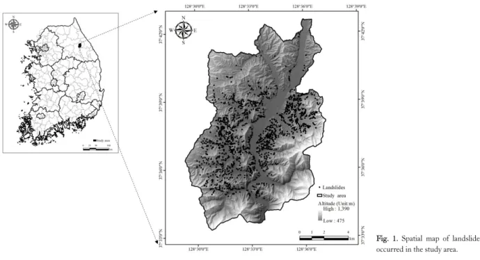
Fig. 1. Spatial map of landslides occurred in the study area.
ducing the soil shear strength eventually leading to slope failures (Sidle et al. 2006). During monsoon rainy season in Korea from June to July 2006, heavy rainstorms hit north- eastern part of Gangwon province and caused many shallow landslides over Jinbu area located within Pyeongchang county. Specifically, those storms released about 440 mm more rainfall in Jinbu area than the national average (340 mm). These intense rainfall was concentrated over Jinbu area during 72 hours (430 mm) before landslide events re- sulting in more than 1,357 landslides or debris flows, and flooding of lower land.
In the present study, we examine characteristics of rain- fall-triggering shallow landslides and casual factors affect- ing landslide distribution with respect to topographic and forest settings, and land use.
Materials and Methods
Study Area
The study area located in Jinbu occupies approximately 127 km2 and extends from 37°33'19" N to 37°42'36" N and from 128°29'21" E to 128°37'11" E. The study area has al- titudes ranging between 475 m and 1,390 m above sea level and slope gradients ranging between 0° and 80° with an average value of 23°. 30 year average annual rainfall is
1,350 mm. The geology of the study area includes the Daebo Granite which is an extensive intrusion of granitoids during the Daebo Orogeny and is distributed over most of the study area (Lee et al. 2012). Bed rock materials over the study area include igneous rock (93%), metamorphic (5.5%) and sedimentary (1.5%) rock. The main land use in the study area is forestland (73%) with a lesser occupation of agriculture land (Fig. 1).
Data collection and analysis
To detect landslide locations, we utilized survey data conducted by local government after 2 months landslide occurrences. Based on these data, all landslides were map- ped in the study area by interpreting web based aerial pho- tographs and some of the landslides were confirmed in the additional field survey (Fig. 1). The number of landslides occurred in the study area during July 14th to 15th 2006 was 1,357. Maps related to landslides occurrence were con- structed in the spatial database using the ArcGIS software package. These map included soil map (1: 25,000 scale), topographic map (1:5,000 scale), land use map (1:50,000 scale), forest type map (1:5,000 scale) and road map (1:5,000 scale).
Contours and survey data points with elevation obtained from topographic maps were interpolated to make a digital
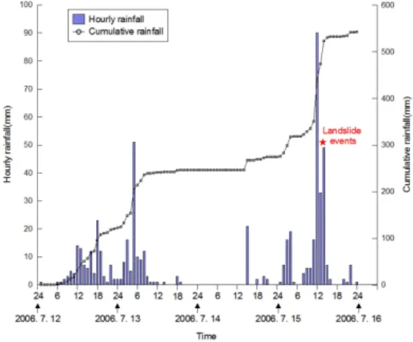
Fig. 2. Rainfall characteristics triggered landslides in the study area.
elevation model (DEM). The DEM has 10 m resolution and was utilized to examine the database on slope gradient and slope aspect. The soil data includes bed rock, soil thick- ness, drainage and texture. The forest database includes tree diameter, age and forest type. Road maps were used to examine landslides that was originated around roads with respect to landslide cause. The rainfall data was collected by meteorological station (37°39'32" N, 128°34'41" E) ob- served by Korea Water Resources Corporation adjacent to the study area and utilized to analyze daily and hourly rain- fall characteristics associated with landslide triggering.
Results and Discussion
Magnitude of the storm triggering landslides
Three typhoons brought highly intensive summer storms during the Korea monsoon season from June through July, 2006. Cumulative rainfall amount fell in Jinbu area during that time was 780 mm and recorded
>50% of its average annual rainfall (1,550 mm) (Fig. 2a).
Jinbu area received about 440 mm more rainfall than the national average (340 mm) during the monsoon season.
These rainfall was concentrated over Jinbu area during 72 hours (430 mm) before landslide events. In particular, heavy rainfall amounts in the Jinbu area over 24 hours from 14th and 15th July 2006 produced 257 mm with highest in- tensity of 92 mm/hr (Fig. 2b). Since rainfall amounts >200
mm during 1 to 3 days was not rare in Jinbu area, this storm resulted in a large number of landslides, debris flows, and flooding of agriculture land due to rapid increase in water levels within the mountainous channels. Kim et al. (2012) found most landslides occurred by heavy rainfall during one to three days with rainfall intensity >30 mm/hr or with cumulative rainfall >200 mm in a study on heavy rainfall for landslide-triggering in Korea.
Landslide characteristics
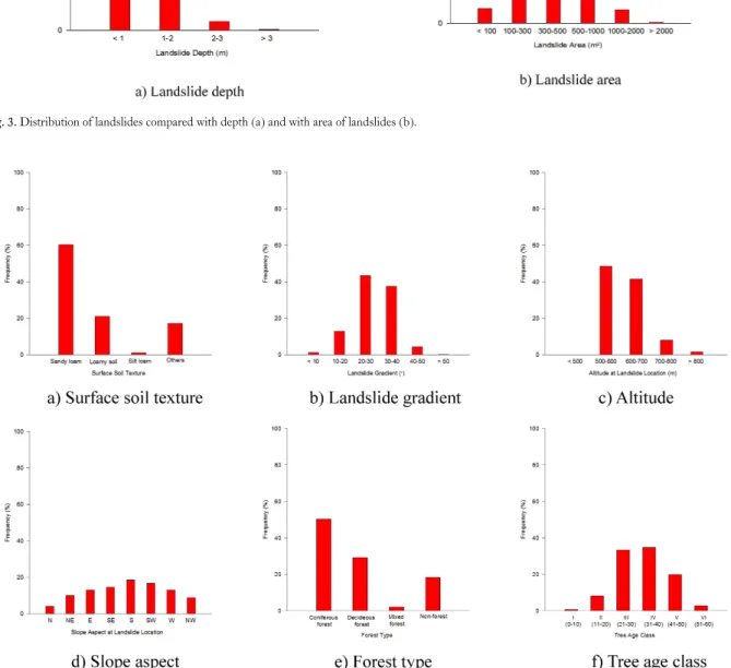
The heavy rainfall of July 15th 2006 in Jinbu area caused at least 1,357 landslides mainly referable to earth and debris flow according to the classification of Varnes (1978). These landslides were mostly shallow landslides with thickness
<2 m and generally involved in slope of granular soils and portions of bedrock (Fig. 3a). The average area of all land- slides (n=1,357) was around 370 m2 with a standard devia- tion of 325 m2. The smallest landslide was only 52 m2 of area, largest around 2,825 m2 (Fig. 3b). In total, the map- ped landslides area occupied 1.5 km2 which is about 1.2%
of the study area (127 km2). Because we expected that not all landslides occurred in the study area were identified, this calculation is an underestimation of the total area occupied by landslides occurred in the study area.
Casual factors affecting landslide trigger
Many studies have investigated an inventory of land-
Fig. 3. Distribution of landslides compared with depth (a) and with area of landslides (b).
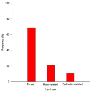
Fig. 4. Distribution of landslides compared to topographic factors and forest settings.
slides distribution resulting from a heavy rainfall over a cer- tain area in temperate monsoon regions (Okuda et al. 1979;
Lee et al. 2012; Lee et al. 2014) in order to examine trig-
gering factors of landslide sites. Thus, the landslides caused by the rainstorm of July 15th 2006 (at least 1,357 land- slides) were examined with some important topographic
Fig. 5. Distribution of landslides compared to land use.
and forest settings to find common landslides-triggering conditions in the study areas.
Although landslides involved most exclusively the soil, surface soil properties is important preconditions for land- slides in the study area (Avanzi et al. 2004). Fig. 4a shows sandy loam has a higher occurrence of landslides than other soil types representing more vulnerable to landslides.
Higher permeability in shallow soil depths with sandy loam soil tends to allow fast saturation during intensive rainfall events resulting in high pore water pressure so it may be- come prone to landslides (Lee et al. 2014). It is believed that steeper slopes are more prone to landslides. However, the landslide occurrence on steeper slopes (>50°) had ac- tually lower frequency due to thinner depth of soil and the exposure of the bedrock in the study area (Fig. 4b). Our re- sult shows the slopes gradient ranging from 20° to 40° had a higher landslide occurrence. This result was in corre- spondence with the study of Lee et al. (2012) resulting in more frequent landslides around slope gradient of 30°. As shown in Fig. 4c, the highest occurrence of landslides occu- pied by elevation between 500 m and 700 m. Since the study area is situated between 450 m and 1,300 m, most landslide were occurred at lower elevation. 33% of those landslides at lower elevation was directly influenced by channel incision or bank erosion. For slope aspect, the high- est occurrence of landslides involved slopes with south- westerly aspects (Fig. 4d).
Vegetation significantly affects hillslope instability re- lated to shallow landslide triggering (Schwarz et al. 2010).
Coniferous forest generally tends to be more prone to land- slides than deciduous forest due to relatively shallow root system. Our result shows coniferous forest (51%) had a higher occurrence of landslides than deciduous forest (29%) (Fig. 4e). In addition, forests with age classes 1 and 2 (ages of 20 to 40 years) are more vulnerable to landslides.
This can be attributable to the weight of trees increasing with age regardless of the root tensile strength, leading to a higher landslide occurrence due to lower slope safety factor within shallow soil depth of the study area (Fig. 4f).
Land use
In the study area, 68% of landslides occurred on forest- land mainly caused by natural causes. This corresponded to forest area occupied by 73% of the total study area.
Although the study had the highest natural frequency of landslides, 21% of landslides originated from forest roads at steep terrain in order to manage forest resources. Generally, forest roads and trail modify site hydrology by decreasing infiltration capacity of the traveling surface, redirecting in- coming rainfall and overland flow and concentrating the runoff into various parts adjacent to roads (Sidle et al.
2006). Additionally, roads cut into hillslopes may intercept surface and subsurface drainages (Guthrie 2002). There were about 11% landslides occurred in hillslope agriculture lands at lower elevation. This was probably related to defor- estation and intensification of agriculture in the past decades. These land use change increases runoff and ini- tiates bank erosion resulting in shallow landslide triggering (Sidle et al. 2006; Broothaerts et al. 2012) (Fig. 5).
Conclusion
Landslides are among the most hazardous soil disaster.
In the present study, we analyzed landslides triggered by in- tensive summer rainstorms of July 15th 2006, Jinbu area of Korea. After analyzing the distribution of 1,357 landslides, we draw some conclusions regarding triggering factors to landslides. Most landslides occurred in the study area were the results of a complex combination of precondition, pre- paratory factors and triggering factors. Cumulative rainfall
and high intensity rainfall during short period of time made the study area very sensitive to landslides and played as cat- alysts to allow other factors including topographic and for- est settings, and land use to act more effectively. In addition, some landslides at lower elevation involved channel incision or bank erosion influenced by land use changes such as de- forestation and intensification of agriculture surrounding riparian forests or hillslopes.
Acknowledgements
This study was carried out with the support of ‘full-time faculty research project (No. 120131228)' funded by Kangwon National University in 2013 and the support of
‘Biosphere reserves and forest protected area management system of De-militarized Zone of Korea (No. S111216 L040110)' funded by Korea Forest Service in 2016.
References
Aleotti P, Chowdhury R. 1999. Landslide hazard assessment: sum- mary review and new perspectives. Bull Eng Geol Env 58:
21-44.
Avanzi GDA, Giannecchini RG, Puccinelli A. 2004. The influence of the geological and geomorphological settings on shallow landslides. An example in a temperate climate environment: the June 19, 1996 event in northwestern Tuscany (Italy). Engineering Geology 73: 215-228.
Broothaerts N, Kissi E, Poesen J, Van Rompaey A, Getahun K, Van Ranst E, Diels J. 2012. Spatial patterns, causes and con- sequences of landslides in the Gilgel Gibe catchment, SW Ethiopia. Catena 97: 127-136.
Chen H, Lin GW, Lu MH, Shih TY, Horng MJ, Wu SJ, Chuang B. 2011. Effects of topography, lithology, rainfall and earth- quake on landslide and sediment discharge in mountain catch-
ments of southeastern Taiwan. Geomorphology 133: 132-142.
Guthrie RH. 2002. The effects of logging on frequency and dis- tribution of landslides in three watersheds on Vancouver Island, British Columbia. Geomorphology 43: 273-292.
Guzzetti F, Carrara A, Cardinali M, Reichenbach P. 1999. Land- slide hazard evaluation: a review of current techniques and their application in a multi-scale study, Central Italy. Geomorphology 31: 181-216.
Keefer DK, Wasowski J, Del Gaudio V. 2006. Special issue from the European Geosciences Union Symposium on landslides in- duced by earthquake and volcanic activity. Engineering Geology 86: 85-86.
Kim SW, Chun KW, Kim JH, Kim MS, Kim MS. 2012.
Characteristics of heavy rainfall for landslide-triggering in 2011.
J Korean For Soc 101: 28-35. (in Korean with English abstract) Lee SW, Kim G, Yune CY, Choi BK, Shin JH. 2014.
Characteristics of landslides occurring below warning criteria for the last ten years in Korea. Disaster Advances 7: 26-35.
Lee SW, Kim GH, Yune CY, Ryu HJ, Hong SJ. 2012.
Development of landslide-risk prediction model thorough data- base construction. J Korean Geotech Soc 28: 23-33. (in Korean with English abstract)
Lin GW, Chen H. 2012. The relationship of rainfall energy with landslides and sediment delivery. Engineering Geology 125:
108-118.
Okuda S, Ashida K, Gocho Y, Okunishi K, Sawada T, Yokoyama K. 1979. Characteristics of heavy rainfall and debris hazard.
National Disaster Science 1: 41-55.
Schwarz M, Preti F, Giadrossich F, Lehmann P, Or D. 2010.
Quantifying the role of vegetation in slope stability: A case study in Tuscany (Italy). Ecological Engineering 36: 285-291.
Sidle RC, Ziegler AD, Negishi JN, Nik AR, Siew R, Turkelboom F. 2006. Erosion processes in steep terrain—Truths, myths, and uncertainties related to forest management in Southeast Asia.
For Ecol Manage 224: 199-225.
Varnes DJ. 1978. Slope movement types and processes. In:
Landslides: analysis and control. Special report 176 (Krizek RJ, Schuster RL, eds). National Academy of Sciences, Washington, pp 11-33.