UAV LiDAR 활용을 위한
데이터 취득 조건별 점밀도 분석
박준규1, 이근왕2*
1서일대학교 토목공학과, 2청운대학교 멀티미디어학과
Pointcloud Density Analysis for Data Acquisition Condition
for Utilization of UAV LiDAR
Joon-Kyu Park1, Keun-Wang Lee2*
1Department of Civil Engineering, Seoil University
2Department of the Multimedia Science, Chungwoon University
요 약 항공 LiDAR(Light Detection And Ranging)는 지형에 대한 3차원 공간정보 구축에 효과적인 기술이며, 최근 UAV(Unmanned Aerial Vehicle)에 탑재가 가능한 장비가 개발됨에 따라 3차원 공간정보 구축 분야에서 관심이 증대 되고 있다. 항공 LiDAR 데이터의 점밀도는 효율적인 공간정보 구축의 중요한 고려사항이지만 UAV LiDAR의 경우 이러 한 기준이 아직 마련되지 않은 상황이다. 본 연구에서는 UAV LiDAR의 데이터 취득 조건별 점밀도를 분석하고자 하였 다. 연구대상지에 대해 비행고도, 비행속도 별 데이터가 취득되었으며, 자료처리 및 분석을 통해 26 pts/m2 ~ 1,267 pts/m2의 점밀도가 산출되었다. UAV LiDAR는 현재 “항공 LiDAR 작업규정”의 기준인 2 pts/m2보다 매우 정밀한 데 이터를 얻을 수 있었으며, 이러한 결과는 공간정보 구축에 UAV LiDAR의 활용 가능성이 충분함을 나타내는 것이다.
한편, 식생이 있는 지역에서 취득한 성과물에서 식생 하부 지면에 대한 점밀도는 138 pts/m2 ~ 355 pts/m2을 나타내 었으며, 이는 UAV LiDAR가 식생이 있는 지역에서도 DEM 구축이 가능함을 나타낸다. UAV LiDAR는 기존의 유인 항 공 LiDAR에 비해 정밀한 데이터 취득이 가능하기 때문에 효율적인 3차원 공간정보 구축에 활용이 기대된다.
Abstract Aerial LiDAR (Light Detection And Ranging) is an efficient method for constructing 3D geospatial information on topography. The interest in related fields has recently increased with the development of equipment capable of being mounted on UAVs (Unmanned Aerial Vehicles). An analysis of the point density of aviation LiDAR data is of high importance as a consideration for efficient spatial information construction. On the other hand, this standard has not yet been established in the case of UAV LiDAR. In this study, the point density for each data acquisition condition for UAV LiDAR applications was analyzed. The data by flight altitude and flight speed were acquired for the study area.
A point density of 26 pts/m2 ~ 1,267 pts/m2 was calculated according to the data acquisition conditions through data processing. UAV LiDAR can obtain much more precise data than 2 pts/m2, which is currently the standard of "Aerial LiDAR Work Regulation". These results indicate that UAV LiDAR is sufficient for obtaining precise geospatial information. On the other hand, the point density on the ground of the achievements acquired in the vegetation area was 138 pts/m2 ~ 355 pts/m2, indicating that UAV LiDAR can be utilized sufficiently for precise DEM(DIgital Elevation Model) construction, even in the vegetation areas. UAV LiDAR is expected to construct efficient 3D spatial information that enables denser data acquisition than existing manned aviation LiDAR.
Keywords : Density, Digital Elevation Model, LiDAR, Pointcloud, UAV 본 논문은 2021년도 서일대학교 학술연구비에 의해 연구되었음
*Corresponding Author : Keun-Wang Lee(Chungwoon University) email: [email protected]
Received June 9, 2021 Revised June 17, 2021 Accepted July 2, 2021 Published July 31, 2021
1. 서론
일반적으로 지도제작, 수치표고모형의 구축 등 넓은 지역에 대한 공간정보 취득 방안으로 항공사진측량이나 항공 LiDAR가 활용되어 왔다[1]. 최근에는 UAV 기술의 발달로 측량, 지도제작, 공간정보 구축 등에 UAV 영상의 활용이 증가하고 있으며[2, 3], “무인비행장치 이용 공공 측량 작업지침”이 제정되어 UAV를 활용한 사진측량에 있어 사용장비 및 성능기준, 작업순서, 대공표지, 사진촬영 등 작업공정에 대한 표준화된 기준이 마련되어 있다[4].
한편, 항공 LiDAR 기술은 수목이 존재하는 산림지역 에서 지면에 대한 정보를 취득하는 효과적인 방법으로 알려져 있으며[5], 기술의 발전으로 장비의 경량화가 이 루어져 UAV에 탑재가 가능한 LiDAR 장비가 출시되고 있다. LiDAR는 레이저를 이용하는 능동형 센서로 초당 수만에서 수십만 개의 레이저 파를 대상지에 주사하여 되돌아오는 파장을 수집하여 지형에 대한 3차원 공간정 보를 취득하는 기술이다[6]. UAV LiDAR는 향후 공간정 보 구축 및 관리 분야에서는 활용이 크게 증가할 것으로 예상되지만 현재는 도입 초기 단계로 관련 연구가 필요 한 실정이다. Fig. 1은 LiDAR의 개념을 나타낸다.
Fig. 1. Concept of LiDAR
유인 항공 LiDAR 및 UAV LiDAR를 활용한 공간정보 구축에서 점밀도는 정밀한 지형분석을 가능하게 하는 중 요한 인자이지만 UAV LiDAR에 대한 기준은 아직 갖추 어지지 않은 상태이다. Table 1은 유인 항공 LiDAR에 대한 점밀도 기준을 나타낸다[7].
Grid spacing Density per m2
1m 2.5
2m 1.0
5m 0.5
Table 1. Point density standard for manned aerial LiDAR
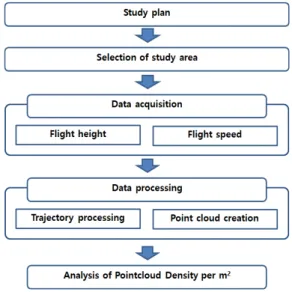
UAV LiDAR는 기존의 항공 LiDAR와 달리 낮은 고도 에서 운용되며, 높은 점밀도의 데이터 취득이 가능하기 때문에 현재의 기준을 적용하는 것은 적합하지 않다. 점 밀도의 관한 규정은 국토지리정보원에서 고시한 “항공레 이저측량작업규정”에 Table 1과 같은 기준이 있으나 UAV LiDAR는 점밀도에 대한 기준이 없어 관련 분야에 원활한 활용이 어려운 상황이다. 이에 본 연구에서는 비 행고도, 비행속도 등 데이터 취득 조건을 달리 하여 m2 당 점밀도를 분석함으로써 UAV LiDAR 활용을 위한 기 초자료를 제공하고자 하였다. Fig. 2는 연구 흐름도를 나 타낸다.
Fig. 2. Study flow
2. 데이터 취득 및 처리
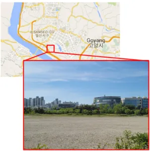
본 연구에서는 UAV LiDAR 데이터의 점밀도를 분석 하기 위해 경기도 고양 인근을 연구대상지로 선정하였다.
연구 대상지는 데이터 취득에 있어 지형의 기복으로 인 한 영향을 줄이고, 안전한 비행을 위해 평탄한 지형을 선 정하였다. Fig. 3은 연구대상지를 나타낸다.
데이터 취득에 사용된 UAV LiDAR는 YellowScan 사의 Mapper이다. Mapper는 100m까지 데이터 취득 이 가능하며, 초당 240,000점의 레이저를 주사한다.
Table 2는 Mapper의 사양을 나타낸다[8].
Fig. 3. Study area
Item Definition
Shape
Weight 1.6 kg
Wavelength 905 nm
Precision 2 cm
Accuracy 3 cm
Field of view 81.7 °
Echoes per shot 2
GNSS-IMU APX-15 UAV
Size 14.4 × 9.5 × 14.2 cm Table 2. Specification of UAV LiDAR
데이터 취득 조건에 따른 m2당 점밀도를 분석하기 위 해 비행고도를 30 m ~ 100 m로 하고, 5 m/s ~ 15 m/s의 비행속도로 데이터를 취득하였다. 한편, UAV LiDAR로부터 취득되는 point cloud 데이터의 특성 상 일정한 지역에 대한 점밀도의 비교 및 분석이 어렵기 때 문에 1 m × 1 m 크기의 타겟을 연구대상지에 설치하여 데이터를 취득하였으며, 데이터 처리를 위해 지상에 GNSS(Gloval Navigation Satellite System) base station을 설치하고, UAV를 운용하였다. Table 3은 데 이터 취득 조건이며, Fig. 4는 비행경로를 나타낸다.
Flight height Flight speed Flight height Flight speed
30 m 5 m/s
70 m 5 m/s
7 m/s 7 m/s
15 m/s 15 m/s
50 m 5 m/s
100 m 5 m/s
7 m/s 7 m/s
15 m/s 15 m/s
Table 3. Specification of UAV LiDAR
Fig. 4. Flight trajectory
데이터 처리는 지상에 설치한 GNSS base station 데 이터를 기준으로 비행경로를 처리하고, point cloud를 생성하였다. 비행경로 처리에는 Applanix사의 POSPac 을 사용하였으며, point cloud 생성에는 YellowScan사 의 Cloud station이 이용되었다. Fig. 5는 데이터처리 화면을 나타낸다.
Fig. 5. Data processing
3. UAV LiDAR 점밀도 분석
데이터 처리를 통해 비행고도 및 비행속도별로 성과물 을 생성하고, 타겟을 추출하여 m2당 점밀도를 산정하였 다. Table 4는 데이터 취득 조건별 타겟 추출 결과 중 일 부를 나타낸다.
Flight
height Flight
speed Density Coverage
30 m
5 m/s 1,267 Pts/m2
55 m 7 m/s 611 Pts/m2
15 m/s 178 Pts/m2 50 m
5 m/s 821 Pts/m2
63 m 7 m/s 447 Pts/m2
15 m/s 108 Pts/m2 70 m
5 m/s 659 Pts/m2
137 m 7 m/s 392 Pts/m2
15 m/s 75 Pts/m2 100 m
5 m/s 439 Pts/m2
176 m 7 m/s 232 Pts/m2
15 m/s 26 Pts/m2
Table 5. Point density and data coverage for each flight condition
Flight
height Flight
speed Target extraction result
30m
5 m/s
7 m/s
15 m/s
Table 4. Example of target extraction result
UAV LiDAR 데이터의 점밀도는 비행고도 및 비행속 도별로 26 pts/m2 ~ 1,267 pts/m2로 나타났다. 연구에 활용한 UAV LiDAR는 장비의 최대 도달거리인 100 m 에서 최고 속도인 15 m/s로 비행하였을 때에도 100 pts/m2 이상의 점밀도를 나타내어 현재 항공 LiDAR 작 업규정의 기준인 2 pts/m2보다 매우 정밀한 데이터를
얻을 수 있었으며, 이러한 결과는 정밀한 공간정보 구축 에 UAV LiDAR의 활용 가능성이 충분함을 나타낸다.
Table 5는 비행조건 별 점밀도와 데이터 취득 폭을 나타 낸다.
본 연구에서는 공간정보 구축 분야에 UAV LiDAR 활 용을 위한 기초자료로 비행고도, 비행속도, 데이터 취득 폭을 고려하여 동일 면적을 촬영하는데 걸리는 시간을 분석하였다. Table 6은 400 m × 400 m 크기 면적의 데이터 취득에 필요한 strip 수와 데이터 취득 요구 시간 을 나타낸다.
Flight
height Flight
speed Data acquisition time Strips 30 m
5 m/s 26 min
13
7 m/s 19 min
15 m/s 11 min
50 m
5 m/s 24 min
12
7 m/s 18 min
15 m/s 10 min
70 m
5 m/s 14 min
6
7 m/s 11 min
15 m/s 7 min
100 m
5 m/s 11 min
4
7 m/s 9 min
15 m/s 6 min
Table 6. Number of strips required for data acquisition and data acquisition time for 0.16 km2
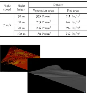
한편 식생이 있는 지역에서 DEM 구축의 활용성을 판 단하기 위해 UAV LiDAR의 지면 데이터 점밀도를 산정 하였다. 대상지에서 취득된 데이터 중 식생이 있는 2 m
× 2 m 지역을 선정하여 식생 하부에 있는 지면 데이터를 추출하였다. Fig. 6은 식생과 하부 지면에 대한 데이터 중 일부이며, Table 7은 평탄한 지형과 식생 지역에 대 한 UAV LiDAR 데이터의 점밀도 비교 결과를 나타낸다.
70m 고도에서 취득한 성과물의 지면에 대한 점밀도 는 138 pts/m2 ~355pts/m2을 나타내었다. 이러한 결 과는 UAV LiDAR가 식생이 있는 지역에서도 정밀한 DEM 구축에 충분히 활용이 가능한 점밀도를 얻을 수 있 음을 나타낸다. Fig. 7은 식생지역 데이터와 이를 이를 이용해 구축한 DEM을 나타낸다.
Fig. 6. Data on vegetation and subsurface
Flight speed Flight
height
Density
Vegetation area Flat area
7 m/s
30 m 355 Pts/m2 611 Pts/m2 50 m 253 Pts/m2 447 Pts/m2 70 m 206 Pts/m2 392 Pts/m2 100 m 138 Pts/m2 232 Pts/m2 Table 6. Comparison of point density
Fig. 7. Vegetation area and DEM
UAV LiDAR 데이터의 점밀도는 비행고도 및 비행속 도에 반비례하고, 데이터 취득 폭은 비행고도에 비례해 넓어진다. 하지만 이러한 변수들 사이의 상관관계는 선 형적이지 않으며 대상지의 지형특성, 식생의 밀도, 계절 등 다양한 요인에 영향을 받게 된다. 향후 도심, 산림 등 다양한 지역을 대상으로 지면 추출 및 DEM 구축에 대한 추가적인 연구가 수행된다면 UAV LiDAR를 활용한 DEM 구축에 대한 활용 가능성을 제시할 수 있을 것이 다.
4. 결론
본 연구는 데이터 취득 조건에 따른 UAV LiDAR 데 이터의 m2당 점밀도를 분석한 것으로 다음과 같은 결론 을 얻었다.
1. 연구대상지에 대해 비행고도, 비행속도 별로 데이 터를 취득하였으며, 데이터 처리를 통해 취득 조건 에 따른 26 pts/m2 ~ 1,267 pts/m2의 점밀도를 산출하였다.
2. UAV LiDAR는 현재 항공 LiDAR 작업규정의 기준 인 2 pts/m2보다 매우 정밀한 데이터를 얻을 수 있었으며, 이러한 결과는 정밀한 공간정보 구축에 UAV LiDAR의 활용 가능성이 충분함을 나타낸다.
3. 식생이 있는 지역에서 취득한 성과물의 지면에 대 한 점밀도는 138 pts/m2 ~ 355 pts/m2을 나타내 었으며, 이는 UAV LiDAR가 식생이 있는 지역에 서도 DEM 구축에 충분히 활용이 가능함을 나타내 는 것이다.
4. UAV LiDAR는 기존의 유인 항공 LiDAR에 비해 밀도 높은 데이터 취득이 가능하기 때문에 3차원 공간정보 구축 분야에 활용이 기대된다. 향후 추가 적인 연구를 통해 도심, 산림 등 다양한 지역에서 취득된 데이터 특성에 대한 분석이 이루어진다면 UAV LiDAR를 활용한 DEM 구축의 활용 가능성 을 제시할 수 있을 것이다.
References
[1] J. M. Cho, J. S. Lee, B. G. Lee, “A Study on the Accuracy Evaluation of UAV Photogrammetry using Oblique and Vertical Images”, Journal of the Korean Society of Surveying, Geodesy, Photogrammetry and Cartography, Vol.39, No.1, Feb. 2021, pp. 41-46.
DOI: https://doi.org/10.7848/ksgpc.2021.39.1.41 [2] J. W. Lee, S. M. Sung, “Edge Response Analysis of
UAV-Images Using a Slanted Target”, Journal of the Korean Society of Surveying, Geodesy, Photogrammetry and Cartography, Vol.38, No.4, Aug.
2020, pp. 317-325.
DOI: https://doi.org/10.7848/ksgpc.2020.38.4.317 [3] Y. S. Lee, D. G. Lee, Y. G. Yu, H. J. Lee, “Application
of Drone Photogrammetry for Current State Analysis of Damage in Forest Damage Areas”, Journal of the Korean Society for Geospatial Information Science, Vol.24, No.3, Sep. 2020, pp. 49-58.
DOI: http://dx.doi.org/10.7319/kogsis.2016.24.3.049 [4] Ministry of Goverment Legislation, Regulation,
[Internet]. Guidelines for Public Surveying using Unmanned Aerial Vehicles. Available From:
https://www.law.go.kr/ (accessed May, 10, 2021) [5] E. J. Cho, D. C. Lee, “Building Detection by
Convolutional Neural Network with Infrared Image, LiDAR Data and Characteristic Information Fusion”, Journal of the Korean Society of Surveying, Geodesy, Photogrammetry and Cartography, Vol.38, No.6, Dec.
2020, pp. 635-644.
DOI: https://doi.org/10.7848/ksgpc.2020.38.6.635 [6] D. J. Hwang, B. J. Kim, J. K. Choi, J. H. Ryu, “Precise
Topographic Change Study Using Multi-Platform Remote Sensing at Gomso Bay Tidal Flat”, Korean Journal of Remote Sensing, Vol.36, No.2-2, Apr. 2020, pp. 263-275.
DOI: https://doi.org/10.7780/kjrs.2020.36.2.2.4 [7] Ministry of Goverment Legislation, Regulation,
[Internet]. Aerial Laser Surveying Work Regulations.
Available From: https://www.law.go.kr/ (accessed May, 10, 2021)
[8] YellowScan, Product, [Internet]. Yellowscan Mapper.
Available From: https://www.yellowscan-lidar.com/
(accessed May, 10, 2021)
박 준 규(Joon-Kyu Park) [종신회원]
• 2001년 2월 : 충남대학교 공과대학 토목공학과 (공학사)
• 2003년 2월 : 충남대학교 대학원 토목공학과 (공학석사)
• 2008년 8월 : 충남대학교 대학원 토목공학과 (공학박사)
• 2011년 3월 ~ 현재 : 서일대학교 토목공학과 부교수
<관심분야>
지형공간정보공학
이 근 왕(Keun-Wang Lee) [정회원]
• 1993년 2월 : 한밭대학교 전자계산 학과 (공학사)
• 1996년 : 숭실대학교 컴퓨터학과 (공학석사)
• 2000년 : 숭실대학교 컴퓨터학과 (공학박사)
• 2001년 2월 ~ 현재 : 청운대학교 멀티미디어학과 교수
<관심분야>
멀티미디어 통신, 멀티미디어 응용, 모바일 통신