https://doi.org/10.7848/ksgpc.2017.35.5.375
A Comparative Study on the NSDI Assessment
Kim, Moon Gie1)·Koh, June Hwan2)
Abstract
United States of America started NSDI in 1994 for the first time in the world. EU and other many countries invested lots of budget on NSDI due to necessity to manage countries and social economy. As skepticism for effect of such investment has risen, developed countries predicted higher effect compared to investment using ROI and other methods. FGDC clarified that geospatial information is a critical national assets. USA has managed NSDI by introducing portfolio concept for it recognizing NSDI as financial assets from fixed assets.
Currently directions of NSDI and its advancement has been proceeded variably depending on corresponding organizations, human resources, budget and national policies. This study analyzed recent trends regarding NSDI assessment methods from developed countries and researchers. Assessment of NSDI is introduced only by some countries such as EU, USA and Canada. This study analyzed USA’s assessment model and indicator that assess NSDI in a way that various external organizations (COGO, URISA) participate, EU INSPIRE Directives, monitoring and Canada’s CGDI assessment methods. Besides these, this study analyzed STIG that adopted Financial Infrastructure from European studies and Korea’s NSDI monitoring assessment indicator research.
Further this study suggested assessment directions for future NSDI through implications of NSDI assessment method analysis.
Keywords : SDI, NSDI, NSDI Assessment, NSDI Indicators, NSDI Monitoring
Original article
Received 2017. 9. 29, Revised 2017. 10. 17, Accepted 2017. 10. 31
1) Member, Dept. of Geoinformatics, University of Seoul, Korea(E-mail: [email protected])
2) Corresponding Author, Member, Dept. of Geoinformatics, University of Seoul, Korea(E-mail: [email protected])
This is an Open Access article distributed under the terms of the Creative Commons Attribution Non-Commercial License (http://
1. Introduction
The report of FGDC (Federal Geographic Data Committee) on December 2016 predicted that geospatial information is a critical national assets and USA’s geospatial information businesses reached at 73 billion Dollars per year and it created 500,000 high salary jobs along with 1.6 trillion Dollar of Geospatial information service, 1.4 trillion Dollar of cost saving and more over 65% of USA’s open data catalogue are geospatial information and economic ripple effects of geospatial information service in strategic decision making areas is predicted to 10% of growth in the next 5 years (FGDC, 2016). Recently recognition of geospatial information values from high decision makers in governments and corporations has increased worldwide and geospatial information is predicted to affect our societies
critically in the next few years (UN-GGIM, 2015). Coppa, et al. (2016) appointed SDI as one of top 18 spatial industry trends of 2016.
SDI (Spatial Data Infrastructure) is a institutional concept whose goal is to improve measurement against requirement of informational society to solve various problems being referred spatially. This concept continues to evolve and it is a core information infra supporting wide social and economic policies in worldwide government organizations.
Advancement of SDI contributes to effective management of spatially referred data and related information wide human activities in public areas for good governance, expediting economic growth and sustainable resource management (Douglas, 2004; Koh, 2007; Rajabifard and Williamson, 2001; Williamson et al., 2003; Williamson, 2004; Williamson et al., 2006).
National Research Council defined the term of NSDI in 1993 for the first time (Pashova and Bandrova, 2017). The next year, in 1994 USA’s NSDI was started for the first time in the world by Executive Order 12906 (FGDC, 2016).
Building of SDI necessary for managing countries and social and economic growth has prompted establishment of each country’s reasonable strategy and action plans depending on each situation in the world and it’s reported that 50% of all countries in the globe are built as of 2002 (Crompvoets et al., 2004). This SDI is under processing in the names of INSPIRE for EU, GDI-DE for Germany, NSDI for Japan, CGDI for Canada, ANZLIC for Australia and New Zealand, UK Location Strategy for United Kingdom and NSDI for Republic of Korea respectively.
Classification of SDI hierarchy(Fig. 1) primarily consists of GSDI (Global SDI), RSDI (Regional SDI), NSDI (National SDI) and LSDI (Local SDI) (Jacoby et al., 2002; Williamson, et al., 2003).
GSDI is top level of SDI which was started Bonn of Germany in 1996. This is focused on SDI whose area is not particular areas such as UN-GGIM, ISPRS and GEO.
This plays a role for international cooperation such as worldwide SDI implementation, supporting practicing and promoting knowledge sharing. This consists of government organizations, academic circles, corporations and individuals, and provides network sharing and best practices to SDI Cookbook Wiki through international conference (GSDI, 2014). RSDI belongs to EU’s INSPIRE (INfrastructure for SPatial InfoRmation in Europe) integration that is accelerated primarily by EU is required to handle environmental issues across Europe, security, traffic and social integration and
other issues. In terms of geospatial information as well, INSPIRE in information strategic business was proposed as necessity by EC (European Commission). In 2007, EC adopted INSPIRE Directives 2007/2/EC for SDI and now 28 MS (Member State) are implementing it (Dangermond et al., 2017; EEA, 2014; Masser, 2015). NSDI is SDI belonging to each country’s level while LSDI indicates SDI for state or local government.
Only some countries including USA, EU and Canada adopted monitoring system and its indicator to enhance level of NSDI and assess level of it. In United States of America owns assessment models for NSDI policies participated by various external organizations (COGO, URISA). In addition, there are also STIG (Stress Test for Infrastructure of Geographic information) that adopted assessment concept for Financial Infrastructure as a European study and Korea’s NSDI monitoring assessment indicator research. The purpose of this study is to analyze NSDI of developed countries that introduced NSDI assessment and monitoring, and to analyze existing NSDI assessment and monitoring indicators in order to provide a desirable NSDI assessment method.
2. Assessment for NSDI in Developed Countries
Geospatial information is a very important asset for a coun- try and many countries are spending budget to build NSDI.
They have concerned over assignment of feasibility against such effects and return on investment as well. NSDI-ad- vanced countries abstracted pretty much positive analysis results. MS Report United Kingdom (UK-INSPIRE, 2013) and MS Report Germany (LG GDI-DE, 2013) analyzed Cost/
Benefit. Measurement guide for ROI (Return On Investment) and CBA (Cost Benefit Analysis) on USA’s NSDI had been published in 2009 based on OMB Circular A-94 Appendix C (USGS, 2009). Real Estate Cadastre Agency of the Republic of Macedonia (2011) practiced CBA as shown in Table 1 for economic decision making to assess NSDI strategy. Nether- lands performed BCA (Business Case Analysis) by adopting Basic model and Collective model in connection with intro- duction of INSPIRE in 2009 (ECORYS Nederland BV. and Grontmij Nederland BV, 2009). United Kingdom performed Fig. 1. SDI hierarchy(source: Williamson, et al., 2003)
CBA in 2014 for UKLP and its estimated cost benefit was predicted to be approximately 1,000£ (Defra, 2014). EC es- timated more than 6 to 7 times of benefits for INSPIRE after 2004 (Craglia et al., 2004).
Although it’s important to predict ROI, CBA and BCA to enhance feasibility of business investment, an objective as- sessment model well matched for national NSDI is required.
USA’s NSDI is deep-rooted and has NSDI model for national level and local level and also assessment model participat- ed by professional civil groups. Chapter 2 suggested USA NSDI, EU INSPIRE and Canada’s CGDI assessment while Chapter 3 analyzed STIG applying Financial infrastructure and Korea’s NSDI assessment indicator researches and sug- gested their implications.
2.1 US assessment : COGO, NSGIC, URISA COGO (The Coalition of Geospatial Organizations) are 16 national professional societies, trade associations, membership organizations for Geospatial information areas. It is Geospatial information institutional association established in 2008 representing more than 30,000 individual producers and users of geospatial data and technology.
This association plays a role for non-organizational forum and expert’s panel to make report card regarding USA’s NSDI performance. This expert’s panel is focused on NSDI framework to assess efforts of federal government. This panel consists of around 170,000 geospatial informational personnel and performs assessment of NSDI with external expert group. They are under processing with country and
local government by cooperating with civil and academic circle to develop NSDI. In 2014, COGO consigned its assessment model to professional committee which makes NSDI Report Card. COGO report model is report card type which is developed by ASCE (American Society of Civil Engineering). This national major infra category every 4 year listed by ASCE. This performance sheet assess all of current NSDI situation, its requirements, score assignment and how to improve score using school score sheet with easy-to- reading A to F level. Performance sheet-approaching method is a tool to assess NSDI’s performance. It is widely used from some countries even to United States of America (Masser, 2017). Fig. 2 shows Grade report of NSDI that was performed Fall in 2014, which indicates COGO submitted it to FGDC.
NSGIC (National States Geographic Information Council) is an organization contributing to government effectively and efficiently through careful adoption of geospatial technologies.
NSGIC used statewide GMA (Geospatial Maturity Assessment) Model. GMA solves problems with objective reports by comparing state-state issues. This enables 7 sections (people, data, processes, policy, strategy, technology, legal) and maturity of related sub-items to be measured. Result of GMA is a general and reliable standard assessment method developed by NSGIC and also makes it possible to monitor and verify statewide geospatial capability. This requires very detailed questionnaire to know characteristics of each state’s geospatial information program (Fig. 3). GMA is a model for every state and supports LSDI. This is based on each item and performance sheet for each category or executable item and
Year Organization Country Type of study Benefit : Cost
2009 Geonovum Netherlands Cost-Benefit Analysis INSPIRE in Netherlands 2 : 1 2007 Information
society department Spain Socio-Economic impact of the SDI of Catalonia 8 : 1
2006 OMB USA Geospatial One Stop 2 : 1
2004 EU INSPIRE EU wide Extended impact assessment for INSPIRE 5.4 : 1 to
12.4 : 1
1995 ANZLIC Australia/
New Zealand Australian SDI benefit study 4 : 1
1993 Government of Victoria Australia Strategic framework for SDI development 5.5 : 1 Table 1. Overview of CBA studies and results
(Source: Real Estate Cadastre Agency of the Republic of Macedonia, 2011)
also available to use as a framework for province, local and government (NSGIC, 2010).
URISA (Urban Regional Information Systems Association) is a non-profit organization to use geospatial information and information technologies effectively and morally to enhance understanding and managing city and local systems and also shares ideas participated by experts from various geospatial information areas. GMI (GIS Management Institute) of URISA approved GMCM (Geospatial Management Competency Model) on June 2012 and GISCMM (GIS Capability Maturity Model) on Oct 2013.
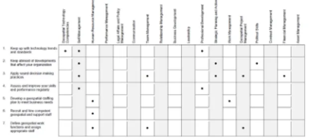
The GMCM specifies 74 essential competencies and 18 competency areas that characterize the work of most successful managers in the geospatial industry (URISA GIS Management Institute, 2015). The GMCM is an element of the USDOLETA (U.S. Department of Labor Employment and Training Administration)’s Competency Modeling Initiative (Fig. 4).
Major purpose for URISA GISCMM is to provide theoret- ical model for capability in assigned organizations and ma- tured corporation GIS works. Most of corporations in civil businesses and industries improve efficiency of jobs more and more and also provide profits based on investment us- ing corporation’s GIS. GISCMM that is proposed for local government by URISA is shown as Fig. 5. URISA GCMM has its purposes to maximize effectiveness of GIS infra in corresponding processes that are developed by matured in- stitutions using sufficiently developed technologies and re- sources.
The EC (Enabling Capability) assessment includes 23 components(Table 2) with a scale modeled after the NSGIC GMA. Because GIS-enabling capability is dependent on resource availability, the GMA scale is well suited to indicate capability. The EA (Execution Ability) assessment includes 22 components(Table 2) and is modeled after the typical CMM process-based, five-level scale (URISA GIS Management Institute, 2015).
Fig. 2. The COGO report card
Fig. 3. State government GMA
Fig. 5. Local government GISCMM (URISA GIS Management Institute, 2015)
Fig. 4. URISA geospatial management competency model (URISA, 2012)
2.2 EU assessment : INSPIRE monitoring As huge amount of public finance is invested every year to build NSDI, all countries and NSDI executive officers have increasingly concerned as to scale of finance for NSDI is feasible and whether such finance is used effectively.
Assessment and monitoring for NSDI policies and plans are urgent issues to secure feasibility of public financial investment. Although initial assessment for INSPIRE showed intuitive aspect, recently it is changed into reasonable assessment using various indicators.
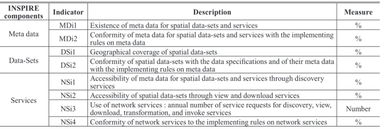
In 2007, INSPIRE’s monitoring system was enacted as a part of Directives 2007. MS needed to report to Commission of the European Communities in order to achieve goals set by INSPIRE and then draft team consisting of experts appointed by Commission of the European Communities developed Implementing Rules after reviewing stakeholder of INSPIRE. As shown in Table 3, meta data is composed
of 2 indicators : MDi1 and MDi2 while spatial Data-sets consists of 2 indicators : DSi1 and DSi2, and Network Services consists of 4 indicators : NSi1, NSi2, NSi3 and NSi4 indicating a total of 8 key technological INSPIRE indicators to monitor INSPIRE (INSPIRE, 2013).
2.3 Canada assessment : 2015 assessment of the CGDI
Canada is running national program on duty and responsibility to lead CGDI (Canadian Geospatial Data Infrastructure) using standard technology and operation policies named GeoConnections and this program has been established in Natural Resources Canada (GeoConnections, 2016). CGDI’s 1st term was 1999~2005, 2nd term was 2005~2010 and 3rd one was 2010~2015, which performed geospatial information policies (KPMG, 2016).
GeoConnections researched worldwide various NSDI EC(Enabling Capability) Component EA(Execution Ability) Component
EC1 Framework GIS Data EA1 New Client Services Evaluation and Development
EC2 Framework GIS Data Maintenance EA2 User Support, Help Desk, and End-User Training
EC3 Business GIS Data EA3 Service Delivery Tracking and Oversight
EC4 Business GIS Data Maintenance EA4 Service Quality Assurance
EC5 GIS Data Coordination EA5 Application Development or Procurement Methodology
EC6 Meta data EA6 Project Management Methodology
EC7 Spatial Data Warehouse EA7 Quality Assurance and Quality Control
EC8 Architectural Design EA8 GIS System Management
EC9 Technical Infrastructure EA9 Process Event Management
EC10 Replacement Plan EA10 Contract and Supplier Management
EC11 GIS Software Maintenance EA11 Regional Collaboration
EC12 Data back-up and security EA12 Staff Development
EC13 GIS Application Portfolio EA13 Operation Performance Management
EC14 GIS Application Portfolio Management EA14 Individual GIS Staff Performance Management EC15 GIS Application Portfolio O&M EA15 Client Satisfaction Monitoring and Assurance EC16 Professional GIS Management EA16 Resource Allocation Management
EC17 Professional GIS Operations Staff EA17 GIS data sharing
EC18 GIS Staff Training and Professional Development EA18 GIS Software License Sharing EC19 GIS Governance Structure EA19 GIS data inter-operability
EC20 GIS is Linked to Agency Strategic Goals EA20 Legal and policy affairs management
EC21 GIS Budget EA21 Balancing minimal privacy with maximum data
usage
EC22 GIS Funding EA22 Service to the community and to the profession
EC23 GIS Financial Plan
Table 2. URISA GISCMM components (URISA GIS Management Institute, 2015)
assessment model and also consulted with international NSDI assessment experts whose purposes are to define practical and cost-effective assessment framework to measure proceeding of CGDI, performance and level of completeness. Assessment of NSDI was proved to be difficult due to its complexity, continuously evolving features and ambiguous definition. Moreover, in terms of comprehensive assessment, it is proved that one single model for all sorts of assessment couldn’t exist due to complexity of NSDI developed worldwide. 9 international NSDI models are reviewed against feasibility of CGDI application and its results are shown as followings :
· INSPIRE State of Play(European NSDI) : This is focused on measurement of advancement in NSDI for membership government including all of quantitative report for usable data/service and qualitative report for governance
· CP-IDEA(NSDI in North and South America) : This emphasizes governance, data/service, social/economic effects
· USA NSDI : 5 categories for potential indicators (Society, environment measure, data, technology and governance)
· Netherlands model : Goal-oriented approach including various assessment indicators
· Suitability of Clearing house : Measuring quality and performance for national clearing house
· NSDI preparation : Measure national capability and wills to use NSDI
· NSDI’s matured level-approach : Verifying NSDI mature matrix and 4 development steps for NSDI development
· Sweden’s success rate measurement : This assesses NSDI’s success rate based on factors to measure social ROI (data, service and user’s point)
· Self-assessment of EUROGI : Its important goal it to help NSDI to describe its own characteristics and to regard nationwide NSDI development as useful inspection list for critical issues
Assessment framework developed for CGDI was based primarily on INSPIRE State of Play (2010/2011)
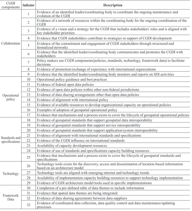
This framework assessed CGDI in 2012 and 2015 and compared its progresses to measure development, use, success and state of Canada’s CGDI since 2010 according to 6th CGDI Performance Project (Fig. 6). Assessment in 2015 performed CGDI assessment measurement data and 33 indicators’s analysis for revised CGDI assessment framework. The CGDI assessment (Table 4) consists of 5 CGDI components including Collaboration, Operational Policy, Standards, Technology and Framework data and the score card for performance result consist of 3 categories (Green : Fully meets the criteria;
Yellow : Partially meets the criteria; and Red : Does not meet the criteria). In addition, this framework expressed progress of performance symbols of Horizontal bar and Vertical INSPIRE
components Indicator Description Measure
Meta data MDi1 Existence of meta data for spatial data-sets and services % MDi2 Conformity of meta data for spatial data-sets and services with the implementing
rules on meta data %
Data-Sets DSi1 Geographical coverage of spatial data-sets %
DSi2 Conformity of spatial data-sets with the data specifications and of their meta data
with the implementing rules on meta data %
Services
NSi1 Accessibility of meta data for spatial data-sets and services through discovery
services %
NSi2 Accessibility of spatial data-sets through view and download services % NSi3 Use of network services : annual number of service requests for discovery, view,
download, transformation, and invoke services Number
NSi4 Conformity of network services to the implementing rules on network services % Table 3. INSPIRE indicators
Fig. 6. Results of CGDI collaboration component
arrows by comparing scores of 2012 assessment results.
CGDI is being matured and it fulfilled almost more than 80%
of standards for assessment targets and its performance was significantly increased since 2012.
2.4 Republic of Korea NSDI assessment
Contents related to assessment of Korea’s NSDI are relying on Enforcement Decree of National geospatial data infrastructure ACT(Article 13) Performance achieved by central government (First half of year) and local government
components IndicatorCGDI Description
Collaboration
1 Evidence of an identified leader/coordinating body to coordinate the ongoing maintenance and evolution of the CGDI
2 Evidence of a network of resources within the coordinating body for the ongoing coordination of the CGDI
3 Evidence of a vision and a strategy for the CGDI that includes stakeholders’ roles and is aligned with key stakeholder priorities
4 Evidence that CGDI stakeholders contribute to strategies in support of CGDI development 5 Evidence of the commitment and engagement of CGDI stakeholders through structured and
formalized networks
6 Evidence that the identified leader/coordinating body communicates and promotes the CGDI with stakeholders
7 Policy makers use CGDI components(policies, standards, technology, framework data) to facilitate decisions
8 Evidence of promotion/exchange of experience with international organizations
9 Evidence that the identified leader/coordinating body monitors and reports on SDI activities
Operational policy
10 Operational policy guidance and best practices 11 Evidence of federal open data policies
12 Evidence of open data policies within other non-federal jurisdictions 13 Evidence of data sharing arrangements other than open data policies 14 Evidence of alignment with international policy
15 Evidence of available resources to develop organizational capacity on operational policies 16 Examples of adoption of geospatial operational policy
17 Evidence that mechanisms and a process exists to cover the lifecycle of geospatial operational policies
Standards and specifications
18 Evidence of geospatial standards that support geospatial data interoperability 19 Evidence of geospatial standards that support service interoperability
20 Evidence of geospatial standards that support application/system interoperability 21 Evidence of alignment with international standards and specifications
22 Evidence of the CGDI influence on international standards 23 Availability of capacity development resources
24 Evidence of use of standards and specifications capacity building resources
25 Evidence that mechanisms and a process exists to cover the lifecycle of geospatial standards and specifications
Technology
26 Technology tools exists for the discovery, access and dissemination of location-based information based on an architecture model
27 Technology tools are aligned with emerging internet and technology trends
28 Availability of implementation capacity building resources to support technology implementation 29 Evidence of CGDI architecture model/tools used in specific implementations
Framework Data
30 Completion of a pre-defined table of data themes to include information 31 Evidence that spatial data themes are being integrated
32 Evidence of data sharing agreements between data suppliers
33 Evidence of coordinated data collection, data quality control and data maintenance/updating processes
Table 4. 2015 assessment of CGDI idicators
(Second half of year) is assessed by experts’ committee consisting of civil GIS professionals and MOLIT (Ministry of Land, Infrastructure and Transport in Korea) by taking into account businesses, outputs, level of usage, business effects and contribution to national geospatial information establishment. Such results are notified to related organizations and it’s recommended to reflect them for next year’s action plans. Although new plan established in every 5 year attempts to assess some of them by reviewing past plans, achievements and problems, it’s merely ended up with assessment only. It’s believed to be somewhat insufficient.
Although a huge amount of budget is invested on NSDI, there is not monitoring as to by which institutions and what kinds of geospatial information is built. Moreover, there is not objective decision supporting data such as feasibility of investment, continuous progressing as they did not analyze effectiveness of NSDI nor monitor such things either.
Besides internal assessment by MOLIT, The Board of audit and inspection of Korea, like US’s GAO, performs NSDI assessment. Started with first audit against local government’s GIS performance in 1994, Korea is performing very strict “Inspect of The Government Offices” every year.
There were revision of policies and reorganizing as results of such audit.
A geospatial information policy is developed by a research of KRIHS (Korea research institute for human settlements) that is an affiliated organization of MOLIT.
3. Implications for NSDI Assessment
3.1 STIG 1.0 research
Coleman et al. (2016) emphasized assessment of NS- DI’s progress and its benefits for effective and efficient development. Worldwide NSDI is still under initial phase for such assessments not fulfilling practical requirement. As the results, he pointed out that there is no performance guide for NSDI yet. In general, financial sectors generally use Stress Test whose purposes are to assess sustainable aspects of system and its success. It’s required to make new frameworks with healthy processes for NSDI assessment and to verify adoptability of STIG 1.0 and availability tests and then supplement them. A total of 24 indicators is assigned as the results of researches.
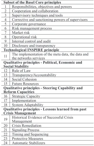
Basel Core Principles used by assessment of FI (Financial Infrastructure) include regulations on soundness and minimum audits by banks and financial systems. After 29 Basel Core Principles using 31 NSDI performance indicators proposed by Crompvoets et al. (2008) are strictly assessed against their compliance, a total 10 The Basel Core Principles including 4 articles for definition of supervising and rights, responsibilities and functions and 6 articles requiring regulations on soundness and requirements are selected for indicators. 8 key technological INSPIRE indicators are applied as quantitative technological principle and indicators. STIG applies INSPIRE monitoring method which adopted new principles and it appointed one indicator which is implementation of the meta data, the data and the networks services. 13 indicators are selected for qualitative principle while there are 4 indicators : political, economic and social stability, 3 indicators : steering
Subset of the Basel Core principles 1 Responsibilities, objectives and powers 2 Cooperation and collaboration 3 Supervisory techniques and tools
4 Corrective and sanctioning powers of supervisors 5 Corporate governance
6 Risk management process 7 Market risk
8 Operational risk 9 Internal control and audit 10 Disclosure and transparency Technological INSPIRE principle
11 The implementation of the meta data, the data and the networks services Qualitative principles - Political, Economic and Social Stability
12 Rule of Law
13 Transparency/Accountability 14 Social Cohesion
15 Future Resources
Qualitative principles - Steering Capability and Reform Capacities
16 Strategic Capacity 17 Implementation 18 System Adaptability
Qualitative principles - Lessons learned from past Crisis Management
19 Historical Evidence of Successful Crisis Management 20 Crisis Remediation
21 Signaling Process 22 Timing and Sequencing 23 Protective Measures 24 Automatic Stabilizers
Table 5. NSDI assessment idicators(STIG 1.0)
capability, reform capacities and 6 indicators lessons learned from past crisis management, and such indicators advanced NSDI assessment indicators (Table 5).
3.2 Republic of Korea assessment research Park (2016) researched the necessity to develop indicators for step-by-step monitoring including establishment of policy making, practicing and management for well- organized NSDI monitoring. Although Korea’s NSDI has achieved various outcomes so far, there are some difficulties to share geospatial information and use geospatial data. In spite of huge amount of resource investment, there was not monitoring as to by institutions and what kinds of geospatial information are built. Moreover there is no objective data such as feasibility of policy investment, sustainable progresses as cost and effective analysis for NSDI and monitoring are not performed. Although some assessments are attempted during establishment of new plans every 5 year and reviewing past performance and problems, such assessments are ended up only with assessment, and 6 policies are abstracted by considering NSDI measurement possibility and policy-oriented importance (Table 6). There
were some indicators that are practically difficult to analyze actual geospatial data for monitoring correlation or there is no reasonable standard to monitor quality levels. This study assigned indicators from existing ones that are available for first adaptation by considering easy-to-implementation. It‘s required to revise, extend and clarify preliminary indicators according to purposes of policy monitoring while assigned preliminary indicators are applied and therefore this study emphasized systematic monitoring and enacting of its guidelines according to National Geospatial Information Basic Law.
3.3 Implications
This study addressed that each country has assessed NSDI differently so far. Especially from worldwide top 2 NSDI : United States of America and EU shows pretty much contrasts against NSDI assessment in terms of assessment targets, its purposes and methods (Masser, 2017). Table 7 summarized the comparison the study by Masser (2017) and Republic of Korea(Park, 2016).
Directions and progresses of NSDI are being carried out differently depending on each country’s organizations and
Indicator Articles Detailed measurement factors and monitoring methods Feasibility
Legal base Individual law, compliance with NSDI
Basic plan Compliance Compliance with goals, strategies and directions for NSDI Complying with
national projects Complying with national projects Redundan-
cy
Contents Redundancy with building, updating of geospatial data Local Redundancy with governing local administration areas Time Time for building, updating of data
Interaction Physical Interaction for projection, coordination and data format Contents Interaction with data model, building and distribution standards
Quality Quality Position accuracy, attributes accuracy, time accuracy, consistency, perfection and reliability and other quality standard
Usage Internal Number of usages from institutions for administrative tasks, time, usages for other departments, and consequential time saving
External Site access through external organizations’ platform and On&Off line, viewing and downloaded data and number of usages
Openness
Scope Measuring openness in connection with geospatial information DB and system, its partial and complete openness
Targets Measuring openness such as closing of geospatial information DB, opening or partial opening for institutions
Method Measuring openness such as closing, offline opening, online opening (file download) and using NSDI through platform
Meta data Measuring openness in terms of meta data for geospatial information Table 6. The monitoring indicator of NSDI(Republic of Korea)
human resources, budget, level of technologies and national policies and there could not be single NSDI assessment for all countries. A researcher Coleman et al. (2016) emphasized assessment of progresses and benefits for NSDI for effective and efficient development. Park (2016) studied on necessities to assign step-by-step monitoring indicators ranging from establishment of policies, implementation and management for systematic monitoring of NSDI. Consequently it's required to revise and extend research results by applying them to NSDI tentatively participated by NSDI experts and also required to systematize NSDI monitoring and enact guidelines according to related laws. Besides these, Cost/
Benefit analysis needs to be accompanied and it’s possible to assess and monitor a country’s NSDI planning and even to utilization.
4. Conclusion
Directions and progresses of NSDI are being carried out differently depending on each country’s organizations and human resources, budget, level of technologies and national policies. In addition, it’s known that each country and researcher’s assessment of NSDI has been attempted differently. Finally this study addressed that there isn’t single and unified NSDI assessment model. This section suggests future directions for developed countries and researchers’
NSDI assessment and monitoring which have been analyzed so far.
First, Changing awareness necessity of NSDI’s values USA manages NSDI by adopting portfolio concept recognizing it as financial assets from fixed assets. In addition, developed countries predicted higher benefits using ROI, CBA and other methods in order to solve skepticism
for invested budget and effectiveness. FGDC asserted that geospatial information is a critical national asset. Countries that haven’t still analyzed NSDI’s value and economic aspects are required to introduce such analysis and let decision makers to aware its benefits for advancement of NSDI.
Second, Changing assessment system for NSDI to external expert group
United States of America has been supporting perfor- mance measurement for government businesses and assess- ment through supporting systems in OMB and GAO. In ad- dition USA owns various NSDI assessment model and also external expert groups such as COGO and even monitors not only NSDI but also LSDI for assessment. Countries which are currently limited to internal assessment need to review change of NSDI assessment by external expert groups be- ing participated. In addition, government’s strong will is re- quired. GMA method proposed by URISA in USA and NSDI assessment and monitoring supported by local government are necessary.
Third, Consulting with external professional expert corpo- rations and international NSDI experts
It’s also desirable to request external private consulting firms or accounting firms other than public organizations’
affiliated groups to participate in NSDI. U.K requested for NSDI plan to external professional expert corporations. In case of Canada, CGDI developed Canada’s own NSDI as- sessment model through consulting with international NSDI experts. Until now, only some developed countries perform NSDI monitoring and its assessment. If other countries that have not attempted these, it would be possible to develop as- sessment model well matched with such countries.
Fourth, Necessities to assign step-by-step monitoring in-
Articles Republic of Korea EU US
Assessment
target Self-assessment by MOLIT Self-assessment by institutes that are partly involved in NSDI implementation
External groups such as COGO and URISA
Assessment purposes
Establishment of new plans and reviewing past
performance and problems Progresses to implement INSPIRE Expecting activities to improve current situation for performance of NSDI
Assessment
methods Internal assessment Internal assessment External assessment Table 7. Comparison of NSDI assessment among Republic of Korea, EU and US
(Adapted from Masser(2017))
dicators ranging from establishment of policies, implementa- tion and management
It's required to revise and extend research results by apply- ing them to NSDI participated by NSDI experts and also re- quired to systematize NSDI monitoring and enact guidelines according to related laws.
Acknowledgement
This study was supported by the 2016 research fund from the University of Seoul.
References
Coleman, D., Rajabifard, A., and Crompvoets, J. (2016), Spatial Enablement in a Smart World, GSDI Association Press, Gilbertville.
Coppa, I., Woodgate, P. W., and Mohamed-Ghouse Z.S.
(2016), Global Outlook 2016 : Spatial Information Industry, Australia and New Zealand Cooperative Research Centre for Spatial Information, Melbourne.
Craglia, M. and Borzacchiello, M. T. (2004), INSPIRE Impact assessment : lesson learned, European Commission Joint Research Center Digital Earth Unit, Ispra, http://
inspire.ec.europa.eu/events/conferences/cost_benefits/
INSPIRE_IA_Lessons_learned.pdf (last date accessed:
29 September 2017).
Crompvoets, J., Bregt, A., Rajabifard, A., and Williamson, I. (2004), Assessing the worldwide developments of national spatial data clearinghouses, International Journal of Geographical Information Science, Vol. 18, No. 7, pp.
665-689.
Crompvoets, J., Rajabifard, A., Loenen, B. V., and Fernández, T. D. (2008), A Multi-View Framework to Assess SDIs, The Melbourne University Press. Melbourne, pp. 193-210.
Dangermond, J., Sankaran, S., Lucchi, R., and Hogeweg, M.
(2017), Article : Re-imagine INSPIRE by leveraging open data and Web GIS, GIS Professional Magazine, Lemmer, https://www.gis-professional.com/content/article/
reimagine-inspire-by-leveraging-open-data-and-web-gis (last date accessed: 29 September 2017).
Defra (2014), INSPIRE Benefits : Guide for data
publishers, Department for Environment Food & Rural Affairs, London, https://data.gov.uk/sites/default/files/
INSPIRE%20Benefits%20Publishers%202014.pdf (last date accessed: 29 September 2017).
Douglas, D. (2004), The SDI Cookbook version 2.0, GSDI(Global Spatial Data Infrastructure), Bonn, http://gsdiassociation.org/images/publications/cookbooks/
SDI_Cookbook_GSDI_2004_ver2.pdf (last date accessed:
29 September 2017).
ECORYS Nederland BV. and Grontmij Nederland BV. (2009), Cost-Benefits analysis INSPIRE : Final report, ECORYS Nederland BV, Rotterdam, https://www.geonovum.nl/
sites/default/files/nkba_engelse_vertaling.pdf (last date accessed: 29 September 2017).
EEA (2014), Mid-term evaluation report on INSPIRE implementation. EEA Technical report(EUR 91574 EN), European Environment Agency, Copenhagen, https://
www.eea.europa.eu/publications/midterm-evaluation- report-on-inspire-implementation (last date accessed: 29 September 2017).
FGDC (2016), National spatial data infrastructure strategic framework, Federal Geographic Data Committee, Reston, https://www.fgdc.gov/nsdi-plan/2017/nsdi-strategic- framework.pdf (last date accessed: 29 September 2017).
GeoConnections (2016), 2016 Invitation for projects, Announcement Code: GNS16IFP, Natural Resources Canada, Ottawa, https://www.nrcan.gc.ca/sites/www.
nrcan.gc.ca/files/earth-sciences/files/pdf/geomatics/
GeoConnectionAO2016EN.pdf (last date accessed: 29 September 2017).
GSDI (2014), GSDI Strategy and strategic plan 2015-2020, Global Spatial Data Infrastructure Association, Bonn, http://gsdiassociation.org/images/official_docs/GSDI_
Strategic_Plan_2015-2020.pdf (last date accessed: 29 September 2017).
INSPIRE (2013), INSPIRE Monitoring indicators guidelines, Infrastructure for Spatial Information in Europe, Brussels, https://inspire.ec.europa.eu/documents/
inspire-monitoring-indicators-%E2%80%93-guidelines- document-0 (last date accessed: 29 September 2017).
Jacoby, S., Smith, J., Ting, L., and Williamson, I. (2002), Developing a common spatial data infrastructure between
state and local government-an Australian case study, International Journal of Geographical Information Science, Vol. 16, No. 4, pp. 305-322.
Koh, J. H. (2007), A study on the national spatial data infrastructure of USA, Journal of the Korean Society of Surveying, Geodesy, Photogrammetry and Cartography, Vol. 25, No. 6_1, pp. 485-497.
KPMG (2016), 2015 Assessment of the canadian geospatial data infrastructure, Klynveld Peat Marwick Goerdeler, Ottawa,
http://ftp.maps.canada.ca/pub/nrcan_rncan/publications/
ess_sst/297/297880/cgdi_ip_0049_e.pdf (last date accessed: 29 September 2017).
LG GDI-DE (2013), Member state report: Germany, Len- kungsgremium Geodateninfrastruktur Deutschland, Frankfurt, http://inspire.ec.europa.eu/reports/country_
reports_mr2012/DE-INSPIRE-Report-2013_ENV-2013- 00433-00-00-EN-TRA-00.pdf (last date accessed: 29 September 2017).
Masser, I. (2015), Article : The first seven years of INSPIRE implementation, GIS Professional Magazine, Lemmer, https://www.gis-professional.com/content/article/
an-autobiography-the-first-seven-years-of-inspire- implementation?output=pdf (last date accessed: 29 September 2017).
Masser, I. (2017), Evaluating the performance of large scale SDIs: two contrasting approaches, International Journal of Spatial Data Infrastructures Research, Vol. 12, pp. 26-38.
NSGIC (2010), NSGIC statewide GMA model, National States Geographic Information Council, New Orleans, https://www.fgdc.gov/organization/coordination-group/
meeting-minutes/2010/september/geospatial-maturity- assessment-model-danielle-ayan.pdf/at_download/file (last date accessed: 29 September 2017).
Park, J. T. (2016), A Study on the Development of Monitoring Indicators for National Geospatial Data Infrastructure Policy, KRIHS, Anyang (in Korean), 38p.
Pashova, L. and Bandrova, T. (2017), A brief overview of current status of European spatial data infrastructures- relevant developments and perspectives for Bulgaria, Geo- spatial Information Science, Vol. 20, No. 2, pp. 97-108.
Rajabifard, A. and Williamson, I. P. (2001), Spatial data
infrastructures: concept, SDI hierarchy and future directions, In Proceedings of GEOMATICS'80 Conference, 21-22 October ,Tehran, Iran, pp. 1-10.
Real Estate Cadastre Agency of the Republic of Macedonia.
(2011), D2.5 Cost-Benefit analysis, Real Estate Cadastre Agency of the Republic of Macedonia, Skopje, http://www.
katastar.gov.mk/userfiles/file/NSDI/Sozdavanje%20 deloven%20koncept/D25%20Cost%20Benefits%20 Analysis%20Corrected.pdf (last date accessed: 7 September 2017).
UK-INSPIRE (2013), Member state report: United Kingdom, United Kingdom-Infrastructure for Spatial Information in Europe, London, https://data.gov.uk/sites/default/files/
UK%20INSPIRE%20Member%20State%20Report%20 2013%20doc_10.pdf (last date accessed: 6 September 2017).
UN-GGIM (2015), Future trends in geospatial information management : the five to ten year vision, Second Edition December 2015, United Nations-Global Geospatial Information Management, New York, http://ggim.un.org/
documents/Future-trends.pdf (last date accessed: 27 September 2017).
URISA (2012), Geospatial management competency model, Urban and Regional Information Systems Association, Des Plaines, http://www.urisa.org/clientuploads/directory/
GMI/Advocacy/GMCM%20final.pdf (last date accessed:
9 September 2017).
URISA GIS Management Institute (2015), GIS capability maturity model, URISA GIS Management Institute, Des Plaines, http://www.urisa.org/clientuploads/directory/GMI/
GISCMM-Final201309(Endorsed%20for%20Publication).
pdf (last date accessed: 4 September 2017).
USGS (2009), Advancing statewide spatial data infrastructures in support of the NSDI, United States Geological Survey, Reston, https://docslide.net/documents/nsgic-march-2006 -advancing-statewide-spatial-data-infrastructures-in- support-of-the-national-spatial-data-infrastructure-nsdi- workshop-on-developing.html (last date accessed: 8 Septem ber 2017).
Williamson, I. P., Rajabifard, A., and Feeney, M. E. F. (2003), Developing Spatial Data Infrastructures: From Concept to Reality, Taylor & Francis Inc, New York. N.Y.
Williamson, I. P. (2004), Building SDIs—the challenges ahead, In Proceedings of the 7th International Conference:
Global Spatial Data Infrastructure, 2-6 February, Bangalore, India, pp. 2-6.
Williamson, I. P., Rajabifard, A., and Binns, A. (2006), Challenges and issues for SDI development. International Journal of Spatial Data Infrastructures Research, Vol. 1, pp. 24-35.