1
An Effective TOA-based Localization Method with Adaptive Bias Computation
Seung-Ryeol Go
*Abstract
In this paper, we propose an effective time-of-arrival (TOA)-based localization method with adaptive bias computation in indoor environments. The goal of the localization is to estimate an accurate target’s location in wireless localization system. However, in indoor environments, non-line-of-sight (NLOS) errors block the signal propagation between target device and base station. The NLOS errors have significant effects on ranging between two devices for wireless localization. In TOA-based localization, finding the target's location inside the overlapped area in the TOA-circles is difficult. We present an effective localization method using compensated distance with adaptive bias computation. The proposed method is possible for the target's location to estimate an accurate location in the overlapped area using the measured distances with subtracted adaptive bias. Through localization experiments in indoor environments, estimation error is reduced comparing to the conventional localization methods.
Key words: Wireless Localization, Time-of-Arrival (TOA), Non-Line-of-Sight (NLOS) errors, Adaptive Bias Computation, Wireless Sensor Networks
* Agency for Defence Development, Korea e-mail:[email protected]
Tel: +82-55-540-6818
Manuscript received Nov 20, 2015; revised Dec 28, 2015;
accepted Dec 28, 2015
This is an Open-Access article distributed under the terms of the Creative Commons Attribution Non-Commercial License(http://creativecommons.org/licenses/by-nc/3.0) which permits unrestricted non-commercial use, distribution, and reproduction in any medium, provided the original work is properly cited.
I. Introduction
Recently, wireless localization systems, which are designed to estimate the location of a mobile device in a wireless sensor network, have received attention. However, a GPS signal is not accessible for wireless localization system in indoor environments. Consequently, wireless sensor networks have been used for location-based services in indoors. In recent years, a variety of approaches for location estimation have utilized the time of arrival (TOA), time difference of arrival (TDOA),
angle of arrival (AOA) and received signal strength indicator (RSSI) methods, as shown in [1]. The TOA method estimates the distance between two nodes, such as a mobile station (MS) and a base station (BS), which can be calculated by multiplying the time a signal arrives by the speed of light. In localization system, finding an accurate TOA measurement has received a great deal of attention for reliable ranging results between two nodes. Due to the high velocity of the propagation of wireless signals, 1ns error in a signal TOA can generate a ranging error of 30cm. Therefore, in wireless sensor networks, the ranging error is an important issue in the performance of localization system. Ranging errors are sorted as bias and random noise errors. Non-line of sight (NLOS) conditions [2], clock offset [3]
and unequal time [4]-[5] are well known reasons for bias errors. Random noise errors are caused by various environmental conditions such as channel fading and multipath [6].
A variety of localization methods have been designed and widely studied to improve the performance of TOA-based localization in wireless sensor networks, as reported in [7]. In this paper, contrary to conventional localization methods, we present an effective localization method with adaptive bias computation.
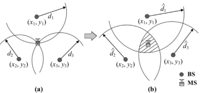
II. System Model in TOA Measurements In TOA-based localization, the estimated MS’s location is calculated using the TOA measurements among the MS and three more BSs in wireless sensor networks. The unique point of the intersection of circles with the distance data using a TOA measurement without error gives the location of the MS, as shown in Fig. 1-(a). However, the circles with the measured distance using a TOA measurement with error do not accurately calculate the unique point of intersection, as shown in Fig. 1-(b), due to ranging errors [2]-[6].
To evaluate the TOA-based location estimation scenario [7] in Fig. 1, the location of the MS and the location of the fixed i-th BS are expressed as x = [x, y]T and xi = [xi, yi]T, respectively.
BS MS d^1
d^3 d^2
d1
d3
d2
(x1, y1) (x1, y1)
(x2, y2) (x3, y3) (x2, y2) (x3, y3)
(a) (b)
Fig. 1. TOA-based location estimation in 2-dimension
The measured distance of TOA measurements
from the i-th BS can be calculated by multiplying the TOA signal by the speed of light and is represented by
( )
ˆ
, 1,2,..., ,
i i i
i i i
i i
d c t t
d b n
d e i N
= × + D
= + +
@ + = (1)
where c is the speed of light, ti is the time of arrival of the signal at the i-th BS, Δti is the error term due to ranging errors such as bias error and random noise, and di is the true distance using the TOA measurements between the MS and the i-th BS as follows:
( ) (
2)
2,i i
i i
d
x x y y
=
= - + -
x - x
(2) where ||·|| denotes the Euclidean distance between the MS’s location and the i-th BS’s location. In TOA measurements, the bias error bi is always positive due to the blockage of the direct signal propagation in NLOS conditions [2] and the delay of an inaccurate timing synchronization in the sensor node [3]-[5]. The random noise ni ∼ Ɲ (0, σi2) is the additive white Gaussian noise (AWGN) with variance σi2, and is very small compared with the bias error. Therefore, the error ei, consisting of the bias error bi and random noise ni always assumes a positive value.
III. TOA-based Localization Methods In this section, we introduce several localization methods that are often utilized for TOA-based localization system, as described in [8]-[12]. The goal of location estimation method is to accurate estimate x = [x, y]T, called the MS’s location in (2).
3.1 Linear Least Squares (LLS)
The linear least squares (LLS) is represented by the matrix form in a non-linear expression of TOA-circles. In NLOS environments, the equation of i-th TOA-circle is expressed as
(
x - xi) (
2+ y - yi)
2= d , i =ˆi2 1, 2,...,N. (3) In order to transform a linear model, we definethe following terms
2 2 and 2 2
i i i
s = x + y , k = x + y . (4) By fixing the equation for i-th BS in (3), we may do some manipulation such as linearization, matrix representation, and subtraction. As a result, we obtain the following linear model as follows [8]
=1 , Aθ 2p
(5) with
= , = , = .
2
1 1 1 1
2
2 2 2 2
2
N N N N
x y -0.5 k - d
x y -0.5 x k - d
y
x y -0.5 s k - d
é ù
é ù
é ù ê ú
ê ú
ê ú ê ú
ê ú
ê ú ê ú
ê ú
ê ú ê ú
ê ú ë û ê ú
ë û ë û
A θ p
M M M M
(6) From the above expressions, we may obtain a LLS solution of the MS’s location, and represent it as follows
(
T)
-1 Tˆ = 1 .
θ 2 A A A p
(7)
3.2 Non-Linear Least Squares (NLS)
The non-linear least squares (NLS) is a localization method which finds the smallest value of distance error among the MS and all BSs. The NLS estimates the location of the MS using the lower complexity least squares approach [9], and is represented as
( )
2=1
ˆ = arg min N i ˆi- - i ,
i
ì w d ü
í ý
î
å
þx x x x
(8) where wi is a scalar weighting factor for the TOA measurements, which is associated with a weighted least squares (WLS) method [10].
3.3 Least Median Squares (LMS)
In [11], the least median squares (LMS) method is a simple localization method using median equation that is proposed for NLOS environments. The LMS is utilized to the median computation in sorting results of the distance error between measured distance and the true distance. The location estimation of the MS using the LMS solution is defined by
( )
{
ˆ 2}
ˆ = arg min medi di- - i ,
x x x x
(9) where medi(·) is the median expression. The LMS is computationally concentrated, and proposes a lower complexity implementation that uses distance error affected noise such as NLOS environments, multipath, etc. However, a performance of the LMS solution is not efficient because of utilizing localization method with distance error (i.e. median of sorting results has distance error).
3.4 Center of Gravity Method using K-means Clustering
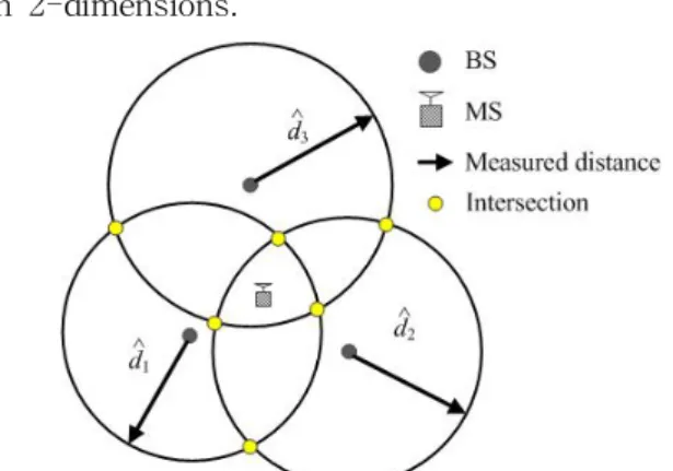
Center of gravity (CoG) method [12] is a localization method using K-means clustering of intersections of TOA-circles. As illustrated in Fig. 2, the TOA-based localization is described in 2-dimensions.
Fig. 2. Illustration of intersections in TOA-circles
By gaining the intersections of TOA-circles using TOA measurements, estimated MS’s location is applied using K-means clustering.
Center of gravity method can be represented by
2
=1
ˆ = arg min - ,
k M
j k
k ÎS
ì ü
ï ï
í ý
ï ï
î
å å
þs x
x x
&
& μ
(10) where x˙ is intersections of TOA circles, j is the number of intersection, and μk is the mean of coordinate in Sk.
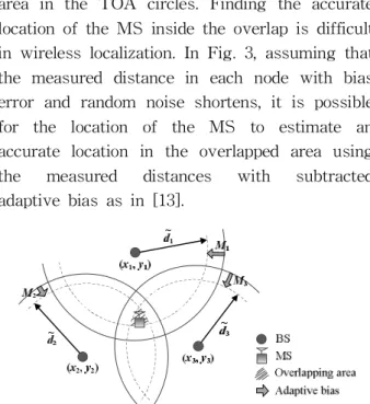
IV. Adaptive Bias Computation As shown in Fig. 1-(b), the localization using the measured distance has an overlapped
area in the TOA circles. Finding the accurate location of the MS inside the overlap is difficult in wireless localization. In Fig. 3, assuming that the measured distance in each node with bias error and random noise shortens, it is possible for the location of the MS to estimate an accurate location in the overlapped area using the measured distances with subtracted adaptive bias as in [13].
Fig. 3. TOA-based localization using measured distances with adaptive bias
As shown in Fig. 3, denoting as the measured distance between the i-th BS and the MS with subtracted adaptive bias, we can represent as
ˆ
, 1, 2,..., ,
i i i
i i i i
i i i
d d M
d b n M
d e M i N
= -
= + + -
= + - =
%
(11) where Mi is the factor of the adaptive bias in measured distance.
Fig. 4. Signal propagation between BSs in wireless sensor networks
In general, two nodes, such as the BS and the MS, are the same device for wireless communication system. Fig. 4 illustrates the signal propagation between the fixed BSs in wireless sensor networks. In common with TOA measurements between the BS and the
MS, the signal propagation between the fixed BSs has a bias error due to ranging errors [2]-[6] in wireless localization. The measured distance between the i-th BS and the j-th BS is
ˆ
ij ij ij,
r = + r e
(12)where ij is the measured distance between the i-th BS and the j-th BS in wireless localization, rij is the true distance between the i-th BS and the j-th BS, and is expressed as rij = ||xi - xj||, eij is the error value consisting of the bias error and random noise between the i-th BS and the j-th BS, i is the number of the selected i-th BS, and j is the number of fixed BSs except for selected i-th BS.
Assuming that the error is independent in each BS, it is possible to calculate the summation of the error values. The Mi is the error value, called adaptive bias, between the selected i-th BS and the other BSs, and is expressed as
( )
1, 1,
ˆ
, , 1, 2,..., .
1 1
N N
ij ij ij
j j i j j i
i
r r e
M i j N
N N
= ¹ = ¹
-
@ = =
- -
å å
(13)
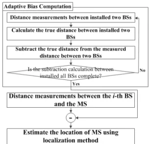
Table 1. Algorithm of Adaptive Bias Computation Algorithm Adaptive Bias Compuation
For the proposed method, before TOA measurements are performed in wireless location estimation, the signal propagation between the BSs is performed and the measured distance is estimated.
1: Set i = 1
2: for each i-th BS (i = 1 to N)
3: for other j-th BS (j = 1 to N, i ≠ j)
4: estimate the measured distance between the i-th BS and the j-th BS
5: calculate the true distance between the i-th BS and the j-th BS
6: subtract the true distance rij from the measured distance
7: end
8: do summation of the error values between the i-th BS and the j-th BS
9: do calculate the average of summation of the error values
10: end
11: do estimate the TOA measurements with adaptive bias
In equation (11), if the value of adaptive bias Mi equals error value ei, the measured distance
would be the true distance di. Also, if the bias value of the measured distance is lower, the performance of the wireless location estimation would be better than conventional localization schemes. In Table 1, we introduce the algorithm for the proposed location estimation method with an adaptive bias computation scheme, and Fig. 5 briefly shows the flow chart of the localization process using the adaptive bias computation.
Fig. 5. Flow chart of the localization process using the adaptive bias computation.
V. Experimental Analysis
To verify the performance of the proposed method, we use a variety of localization methods, as described in Section III. In the LLS method, to obtain a linear model of TOA measurements, a location estimation technique is presented for countervailing the non-linear term of TOA measurements. The NLS method is a well-known location estimation technique for minimizing error function. The WLS method is an advance location estimation technique of NLS, and some adaptive weights can be used featuring the reliability of each measured distance between the MS and the i-th BS. The
LMS technique is presented for mitigation of NLOS errors and is an effective fitting algorithm in NLOS environments. The CoG method is a localization method using K-means clustering of intersections of TOA-circles in TOA-based localization. We used the chirp spread spectrum (CSS)-based wireless sensor network system developed in [14]-[15]. We performed the localization experiment with 6-fixed BSs in an underground parking lot and gymnasium with interference and multipath environments. Then, we conducted localization experiments from several MS’s locations in experimental conditions. The results of TOA measurements were sent to a server computer, which calculated the location of the MS using the localization technique [8]-[12]. The proposed method with adaptive bias scheme shows more accurate estimation results than the other localization methods used alone.
5.1 Gymnasium with Interference and Multipath Environments
Fig. 6. Experimental environment (Gymnasium)
The localization simulations using the proposed method were compared with LLS, NLS, WLS, LMS, and CoG methods. The verification for the localization was performed in a 36 × 22 meter gymnasium with the presence of interference and multipath, as shown in Fig. 6.
For the simulation test, we placed six BSs at locations with the coordinate values [1.5, 1.1]T, [1.5, 20.5]T, [34.7, 20.5]T, [34.7, 1.1]T, [19.1, 1.1]T, and [19.1, 20.5]T 1.7 meters high. The MS’s location for the experimental test was placed in several locations with coordinate values of [7.9,
6]T, [19.1, 10.5]T, and [27.8, 15]T 1 meter high.
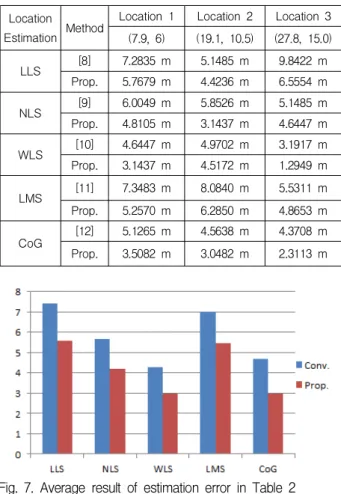
To compare the estimation error, we calculated the MS’s location using the various localization methods. To account for the different height of the BS and MS, we used the Pythagorean theorem. Tables 2 shows the experimental results of the performance analysis comparing localization methods [8]-[12] with adaptive bias computation method. Fig. 7 shows the experimental result, which is average data in Table 2. The average estimation error of the proposed localization method is reduced by about 25% comparing to the conventional methods.
Table 2. Estimation Error of the Localization and Proposed Method in Gymnasium
Location
Estimation Method Location 1 Location 2 Location 3 (7.9, 6) (19.1, 10.5) (27.8, 15.0)
LLS [8] 7.2835 m 5.1485 m 9.8422 m
Prop. 5.7679 m 4.4236 m 6.5554 m
NLS [9] 6.0049 m 5.8526 m 5.1485 m
Prop. 4.8105 m 3.1437 m 4.6447 m
WLS [10] 4.6447 m 4.9702 m 3.1917 m
Prop. 3.1437 m 4.5172 m 1.2949 m
LMS [11] 7.3483 m 8.0840 m 5.5311 m Prop. 5.2570 m 6.2850 m 4.8653 m
CoG [12] 5.1265 m 4.5638 m 4.3708 m
Prop. 3.5082 m 3.0482 m 2.3113 m
Fig. 7. Average result of estimation error in Table 2 5.2 Parking lot with NLOS, Interference and Multipath Environments
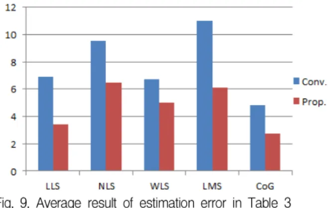
In a 110 × 40 meter parking lot with the presence of NLOS errors, interference and multipath, as shown in Fig. 8, the experimental
tests were performed. Since a steel frame, car, and wall are present, the parking lot is a more realistic environment than the gymnasium. Base stations, using 2.4 GHz for telecommunications, were already installed in the underground parking lot for mobile phone communication.
Our wireless devices [16], based on CSS [14]-[15], could be influenced by interference from the 2.4 GHz devices [17]. To compare the localization methods, we installed our BSs at locations with the coordinate values [10.52, 11.5]T, [10.52, 34.6]T, [90.04, 34.6]T, [90.04, 11.5]T, [56.98, 11.5]T, and [56.98, 34.6]T 1.7 meters high.
We installed the MS in locations with the coordinate values [30.2, 19.7]T, [56.2, 19.7]T, and [72.8, 19.7]T 1 meter high. The simulation results are shown in Tables 3. Fig. 9 shows the experimental result, which is average data in Table 3. The average estimation error of the proposed localization method is reduced by about 38% comparing to the conventional methods.
Fig. 8. Experimental environment (Parking lot)
Table 3. Estimation Error of the Localization and Proposed Method in Gymnasium
Location
Estimation Method Location 1 Location 2 Location 3 (30.2, 19.7) (56.2,19.7) (72.8, 19.7)
LLS [8] 6.8412 m 8.3935 m 5.4885 m
Prop. 3.1379 m 4.2383 m 2.8429 m
NLS [9] 10.2809 m 9.8422 m 8.3956 m
Prop. 5.6468 m 8.0986 m 5.6797 m
WLS [10] 5.8526 m 7.3483 m 6.9981 m
Prop. 3.8323 m 5.6703 m 5.5311 m LMS
[11] 11.9696 m 9.6332 m 11.3099 m
CoG
Prop. 6.2043 m 6.9088 m 5.1467 m [12] 4.5410 m 5.4720 m 4.4932 m Prop. 2.5083 m 3.0375 m 2.7415 m
Fig. 9. Average result of estimation error in Table 3
VI. Conclusions
In wireless sensor networks, the presence of ranging errors is an interesting issue, because they can significantly degrade the performance of wireless localization system. As a result, a variety of localization methods have been investigated. In this paper, we present a simple localization method: a mathematical method to reduce random noise and bias error in TOA measurements. In wireless sensor networks, wherever the localization system is installed, a proposed localization method can be applied.
The proposed localization method is a step taken before estimating MS’s location. As long as the proposed method has been applied, The accuracy of TOA-based localization method with adaptive bias computation shows more accurate estimation results than that obtained using conventional localization methods.
Through experimental results, the average estimation error of the proposed localization method is reduced by about 30% comparing to the conventional methods. Thus, the proposed method is well suited to various TOA-based localization methods in wireless sensor networks.
References
[1] Kupper, and Axel (2005) "Location-based services: fundamentals and operation", Wiley, New York ISBN: 0-470-09231-9
[2] Y. T. Chan, W. Y. Tsui, H. C. So, and P.
C. Ching, "Time-of-arrival based localization under NLOS conditions", IEEE Transactions on Vehicular Technology, vol. 55, no. 1, pp. 17-24, Jan. 2006
[3] Y. Jiang, and V. C. M. Leung, "An Asymmetric Double Sided Two-Way Ranging for Crystal Offset", International Symposium on Signals, Systems and Electronics 2007, pp.
525-528, July 2007
[4] L. J. Xing, L. Zhiwei, and F. C. P. Shin,
"Symmetric Double Side Two Way Ranging with Unequal Reply Time", IEEE 66th Vehicular Technology Conference 2007, pp.
1980-1983, Sept. 2007.
[5] H. Kim, "Double-sided two-way ranging algorithm to reduce ranging time", IEEE Communications Letters, vol. 13, no. 7, pp.
486-488, July 2009
[6] A. H. Sayed, A. Tarighat, and N.
Khajehnouri, "Network-based wireless location:
challenges faced in developing techniques for accurate wireless location information", IEEE Signal Processing Magazine, vol. 22, no. 4, pp.
24-40, July 2005
[7] I. Guvenc, and C. C. Chong, "A Survey on TOA Based Wireless Localization and NLOS Mitigation Techniques", IEEE Communications Surveys & Tutorials, vol. 11, no. 3, pp.
107-124, 3rd Quarter 2009
[8] J. J. Caffery, and G. L. Stuber, "Overview of radiolocation in CDMA cellular systems", IEEE Communication Magazine, vol. 36, no. 4, pp. 38-45, Apr. 1998
[9] I. Guvenc, C. C. Chong, and F.
Watanabe, "Analysis of a Linear Least-Squares Localization Technique in LOS and NLOS Environments", IEEE 65th Vehicular Technology Conference 2007, pp. 1886-1890, Apr. 2007
[10] B. T. Sieskul, F. Zheng, and T. Kaiser,
"Time-of-arrival estimation in path attenuation", IEEE 10th Workshop on Signal Processing Advances in Wireless Communications 2009, pp. 573-577, June 2009 [11] Z. Li, W. Trappe, Y. Zhang, and B. Nath,
"Robust statistical methods for securing wireless localization in sensor networks", Fourth International Symposium on Information Processing in Sensor Networks 2005, pp. 91-98, Apr. 2005
[12] S. Go, S. Kim, Y. Li, and J. Chong,
"Improved TOA-based Localization Method using weighting factor in NLOS Environments", Intrernational Conference on Green and Human Information Technology 2015, pp. 243-246, Feb.
2015
[13] B. Lee, H. Hur, and H. Ahn,
"Environmental-Adaptive Bias Calibration in Wireless Localization", IEEE Communications Letters, vol. 17, no. 4, pp. 717-720, Apr. 2013 [14] IEEE Standard 802.15.4a-2007, pp. 1-203, Aug. 2007
[15] ISO/IEC Standard 24730-5, pp. 1-72, Mar.
2010
[16] D. Oh, M. Kwak, and J. Chong, "A Subspace-Based Two-Way Ranging System Using a Chirp Spread Spectrum Modem, Robust to Frequency Offset", IEEE Transactions on Wireless Communications, vol.
11, no. 4, pp. 1478-1487, Apr. 2012
[17] H. Hur, and H. Ahn, "A Circuit Design for Ranging Measurement Using Chirp Spread Spectrum Waveform," IEEE Sensors Journal, vol. 10, no. 11, pp. 1774-1778, Nov. 2010
BIOGRAPHY
Seung-Ryeol Go (Member)
2011 : BS degree in Electronics and Computer Engineering, Hanyang University, Seoul, Korea.
2015 : MS degree and PhD degree in Electronics and Computer Engineering, Hanyang University, Seoul, Korea.
2015~ : Researcher, The 6th Research and Development Institute, Agency for Defence Development, Korea.