Development in Geomorphology and Soil Geography: Focusing on the Journal of the Korean Geomorphological Association
Kyeong Park*
한국지형학회지를 중심으로 본 지형학과 토양지리학의 발달
박 경*
Abstract : Last review papers on Korean geomorphology and physical geography had been published in 1997 and 2000 respectively. A proposal to publish a book on Korean geomorphologists’ achievement resulted in series of review papers in Journal of the Korean Geomorphological Association. This article aims to summarize these papers and introduce their findings to foreign scholars. On remarkable achievement is a fierce debate on the effectiveness of traditional mountain concept to explain the shape of Korean peninsula, which made the public’s understanding of geomorphology widen to the general public.
Reflecting public demands, concerns for the effects of coastal facilities on coastal erosion and conservation mind and scientific researches for the coastal sand dunes have increased so much. Geomorphological hazards such as debris flow attracted many concerned scientists, and geotourism-related papers in scientific journals increased thanks to the designation of first geopark in Korea. Research papers submitted to the famous foreign academic journals are increasing in numbers these days.
Key Words : Journal of the Korean Geomorphological Association, mountain ranges, coastal landform, coastal sand dune, natural hazard, geotourism
요약 :오경섭(1997)과 손일(2000)에 의한 지형학과 한국의 자연지리학 연구 성과에 대한 정리가 있은 후, 처음 으로 한국지형학회지를 통해 2011년과 2012년에 걸쳐 지형학 각 분야 성과에 대한 정리가 있었다. 이 논문은 이들 연구 성과를 종합하여 지형학과 토양학 분야에서 이루어 놓은 성과를 정확히 소개하고자 하는 데 연구의 목적이 있다. 2000년 이후 특히 주목할 만한 성과는 우리나라의 전통적인 산지체계와 서양의 근대적 산맥론과 관련된 수년간에 걸친 논쟁을 통해 뚜렷한 성과는 없었지만 학계에만 머물던 지형학이 대중매체에게 알려졌다 는 것이며, 둘째는 사회적 수요를 반영하여 해안 지역의 구조물과 해안도로 등의 개발과 이에 따른 해안지형의 변화가 주요한 주제가 되고 있으며, 해안사구를 비롯한 해안퇴적 지형의 연구 성과가 크다는 점이다. 기후변화 로 인한 자연재해의 증가는 산사태와 같은 방재지형학적 연구의 필요성을 증대시키고 있고, 제주도의 지질공 원 지정에 따른 지오투어리즘 분야의 연구 성과가 주목할 만하다. 최근 한국의 연구 성과가 해외저널에 소개되 기 시작한 점은 고무적이며, 이러한 추세는 지속될 것으로 판단된다.
주요어 : 한국지형학회지, 산맥론 논쟁, 해안지형, 해안사구, 자연재해, 지오투어리즘
This work was partly supported by Sungshin Women’s University’s research grant no. 2010-1-11-022.
* Associate Professor, Department of Geography, College of Social Sciences, Sungshin Women’s University, kpark97@sungshin.
ac.kr
1. Introduction
Goemorphological Society of Korea has had a turn- ing point in 1990s since the establishment of Korean Geomorphological Association and the initiation of nationwide landforms survey as a part of “The Na- tional Natural Environment Survey” which is initiated and funded by the Ministry of Environment of the Republic of Korea (Kim and Yun, 2008). As 0f 2009, there are no more than 145 professors in Korea, of which physical geographers make up 20.8 % and they are mostly geomorphologists. They published their researches in five major scientific journals. The author classified researches done in Korea focusing on journal of the Korean Geomorphological Association accord- ing to landform process as follows:
(1) Fluvial landforms; Depositional landforms, Ero- sional landforms
(2) Mountain Topography; Debates on mountain ranges, Granite weathering
(3) Coastal Geomorphology: Tidal flats, General coastal geomorphology
(4) Structural and Karst Geomorphology (5) Applied Geomorphology
(6) Soils in Geomorphology
Regarding the above categorization, the following must be admitted. They do not present complete ob- jectivity and writer’s subjectivity play a part in classify- ing the landform influenced by more than one of the agencies into one of the above categories. It might also be possible that an important thesis was dropped from the list for this analysis. The Korean Geomorphologi- cal Association prepared special publications regarding the history of geomorphological studies on several sub- jects of geomorphology from 2011 to 2012, and this paper owes a lot to these summary papers during the
preparation.
2. Fluvial geomorphology
In this chapter, the author divided fluvial researches into depositional and erosional landforms studies and summarized research trends mainly after year 2000.
1) Depositional landforms
Fluvial geomorphology in Korea has been studied mainly on places suitable for human settlements. Nu- merous hills and mountains are the main component of Korean landscape, therefore alluvial plains and fluvial terraces offer valuable flat surface where people can live on thousand years, which explains the reason why they become the center of fluvial geomorphol- ogy. Fluvial terraces also offer valuable subject for the paleo-climatic reconstruction because they contain sediments from various quaternary age deposits.
Studies on flood plain and delta started in 1970s and lead by Kwon H.J. He investigated the age of forma- tion of Nakdonggang River delta through the recon- struction of formation processes and divided delta top- ographic units into upper, lower delta and surrounding basin. He continued and expanded his research to other major rivers, and found that the thick sediments of coastal Honam plain has been formed during the sea level rise, and that back swamps of Nakdonggang river basin has been formed after sea level reached pres- ent level. Many master theses on that subject have been submitted in 1970s.
Two eminent scholars like Kwon H.J. and Jo H.R.
lead the fluvial research circle in 1980s, the former focused his researches in landform and land use in al- luvial plain, and the latter did in sedimentary structure and quaternary environment. Kwon H.J. also proposed
a division system of the alluvial plain in Hangang Riv- er into several landform units (1984) and investigated characteristics and development processes in two allu- vial plains. Jo (1982, 1986) investigated subtle changes in sedimentary structures in the estuarine deposits and studied sea level changes. He published a book as a culmination of his lifelong research in 1987, its title is
“Korean Alluvial Plains”.
From 1990s to 2000s, their fluvial landform studies are followed by their graduate students. Lee (1993), who is Kwon’s student, performed granulometric and geochemical analyses to classify the micro-landforms on fluvial terraces and investigated the changes in landforms. Hwang and Yoon (1998) performed the first historical landform studies in Daegu basin. In 2000s relatively few studies have been done in alluvial landforms compared with other geomorphological studies. Lee (2003)’s work in Chuncheon basin, and work on Jucheongang river (2005) and Yoon and Hwang’s researches are few outcomes of riverine land- forms in this period.
During the 20th century, researches on fluvial ter- race have become the mainstream of fluvial landform studies. This trend has not been changed till today, however diverse scientific methodologies are applied in this field. Geographic information system, mineralogi- cal and chemical analyses have been widely applied to the fluvial terrace studies. Fluvial terrace become the main focus of fluvial landform studies, occupies sixty percent of whole fluvial landform studies as a matter of facts.
One of the most important progresses is the in- troduction of age determination technologies into geographical area especially luminescence dating tech- nique to determine the absolute age in the fluvial ter- race studies. Lee et al. (2003) applied thermolumines- cence technology to the terrace deposits of paleolithic era at an archaeological site in Imjingang River. Lee G. R. is an active young scientist who applied various
analytical technologies such as thickness of weather- ing rind, redness index, XRD and XRF to determine the weathering degree and to reconstruct paleoenvi- ronment. Many research papers have been published applying optical luminescence technique since the middle of 2000s, of which classification of terrace into climatic terrace and sea level change terrace is one, erosion rate determination in Chatancheon River is another and comparison of western and eastern slope of Taebaek Mts. is also very important (Lee, 2011).
Different opinions for the development of terrace deposits have come from other scholars with differ- ent academic background, among them Yang (2008) argued that fluvial terraces in coastal area in South Sea were formed during the glacial period when large sup- ply of debris material came from physical weathering processes during the last glacial period.
2) Erosional landforms
Among a few researches on erosional landforms in bedrock river channels, micro-landforms such as pot- holes rather than macro-landform such as waterfall or stream channels themselves has been the focus of aca- demic researches. After the year 2000, most researches are on geological and structural control over the formation of channel. In a recent paper, Kim (2011) reviewed and summarized the research papers on the subject of erosional landforms developed in bedrock channels, he pointed out that Lee (1985) classification of potholes into six classes and Ko and Hong (1999)’s report on pothole types developed in Jirisan National Park area are relatively important in the history of bed- rock channel studies. Ko and Hong (1999) listed water fall, rapids, plunge pool, pothole, falling stone and bed rock channels as important landscape resources in their study area.
Studies focused in macro-landforms started after the year 2000, Kim (2005), for the first time, classified
thirty waterfalls in Seoraksan national park (granite), Jejudo Island (basalt), and Hantangang River (basalt) by analyzing cause and development history of them.
Kim in her thesis maintained that waterfalls in granite regions are mainly formed through the headward ero- sion as a replacement retreat slope; however, waterfalls of basalt region have been formed by the parallel re- treat due to the characteristic columnar joints devel- oped in basalt.
Micro-landforms including potholes and groove have been the focus of Park’s research (2002). He ex- plained the development of potholes and grooves is the results of direction and density of joint system. He ascribed the pothole development to the abrasion and granular disintegration of minerals due to the frequent freeze-thaw and wet-dry cycles. Kim and Bae’s 1987’s paper on Gapyeongchen River classified potholes into four types according to joint system and presence of schistose structure, many potholes turned out to be not related to the joint system in this study (Kim, 2011). In his 2011 paper, Kim suggested the quantita- tive studies on relationship among the many variables working on bedrock channels should be inquired closely to make a progress in bedrock landforms. He applied new techniques including cosmogenic nuclides to estimate erosion rate and exposure ages of bedrock surfaces.
3. Mountain Topography
The research papers on mountain topography in five major geography journals since 1990s are classified by Kang(2011) and Kwon (2007).
1) Debates on mountain ranges
Mountain ranges (Sanmaek) in Korea can be di-
vided into two categories based on their formation (Kwon, 2000). The primary mountain ranges are closely related to tectonic movement, while second- ary mountain ranges have been formed by erosional processes upon old surface. The primary mountain ranges could well be defined since they lie along the Cenozoic uplift axis, while the secondary mountain ranges are low and less prominent; therefore it is hard to recognize their presence both in the field and labo- ratory. This fact causes a rare but pierce debate among the Korean geomorphologists, because a small number of professional researchers in government-supported institute doubt the presence of mountain ranges and maintained that mountain ranges are nothing more than remnants of past geological structure and west- ernized concept, and the Baekdudaegan which is tradi- tional concept of mountains is more appropriate than the concept of mountain ranges developed in geologi- cal standpoint to explain the mountain landforms in Korea (Kim and Im, 2005). Park and Son (2005) concluded that they were able to prove the existence of most mountain ranges, which provides a useful frame- work to understand the geological evolution of Korean peninsula and formation of mountainous landscape of Korea. They also maintained that it is necessary to characterize the types of mountain ranges according the genesis, the purpose of usages and also the scale of maps.
Since the designation of the Jirisan National Park in 1967 for the first time, nineteen more parks have been designated as national parks; among them fifteen are mountain national parks. Since 1980s natural re- sources surveys mandatory in “Natural Park Law”of Korean government to develop park management strategies should be planned in every ten year, in which geomorphologists are actively involved, which is very helpful to enlist valuable geomorphological resources in national parks. Both nation-wide “The Natural Environment Survey” organized by the Ministry of
Environment and national park survey play a vital role in the development of Korean geomorphology (Kim and Yun, 2008).
2) Granite weathering landforms
Kwon (2007) originally summarized studies on granite weathering landforms in Korea. In his opinion, studies on weathering landforms are headed in two directions; studies on regolith and micro-topography induced by weathering. Regolith studies are focused on the paleo-climatic environments when that regolith is thought be formed. Subjects for micro-landforms studies include tor, tafoni, gnamma, bornhardt, groove, exfoliation joint, and flared slopes, many grad- uate students’papers and publications out of natural environment survey dealt with the micro-landforms in granite area (Figure 1).
Kang (2011) also reviewed the granite landform studies by Korean geographers as a work for the special publication. He classified two landform elements, which are a mountain or hilly element and low land or
valley environment. He argued that domes, cliffs and tor are typical mountain landscape elements of Korean granite landforms, which are derived from the differ- ential weathering controlled by the density of joint sys- tem. Valleys covered with fluvial deposits are the other landscape elements.
Park in his 1999 article summarized many weath- ering-related papers in Korea and concluded that many workers have not reached the conclusion so far.
The consensus, however, is that micro relief found in weathered granite resulted from salts derived from chemical weathering initiated along joints and frac- tures, especially those where water can reside tempo- rarily at least. Remaining unsolved questions are as follows; firstly, whether tafoni are the results from the sub-areal or under-ground weathering. Secondly, tafo- ni may indicate climatic conditions of the past in some cases. Thirdly, basal rock properties may determine the development of tafoni. Fourthly, distributions are not restricted to coastal areas with ample supply of sea salt and actually they are plenty in granite area far from the coastal area. And finally, the textural properties of host
Figure 1. Insubong peak, which is a typical granite dome in Bukhansan National Park, Seoul.
rock can control tafoni.
4. Coastal Geomorphology
The research papers on coastal landforms in five major geography journals since 1990s are analyzed sta- tistically and classified by Kim (2012) and Jang (2011).
The study of coastal geomorphology in Korea started from 1970s and has made a significant progress both in methodology and in quantity since 1990s. Many of re- cent coastal studies focused on the formation processes of coastal dunes and their management reflecting pub- lic’s high interest of environmental conservation.
1) Tidal flats
Studies on tidal flats have been started when geo- morphology has become a main body of geographical studies in 1970s. From 1970s to 1990s as most of Ko- rea’s large scale reclamation projects have been contin-
ued, scientific concerns for the tidal flats increased. In 2000s, as most projects finished, quantity of researches on tidal flats diminished dramatically, however, re- searches adopting remote sensing techniques increased exceptionally. Researches on tidal flats can be divided into many sub-disciplines including sedimentary stud- ies, topographic analyses using remote sensing tech- niques, Quaternary environmental changes in tidal flats, and bio-geographical studies (Jang, 2011).
Park (2001) compared two famous tidal flats in Ko- rea, namely Suncheonman (bay) and Gangwhaman tidal flats, and ascribed the differences in mean par- ticle size to the difference in tidal range. Ryu (2003) investigated the seasonal variation of particle size in Hampyeongman and Gwnagyangman areas. Lee and Cho (2005) did similar analyses in Beopseongman;
Jang et al. (2010) did in intertidal zone in Baramarae beach, and Shin (2011) in his latest Ph. D. dissertation spatio-temporal variation of sedimentary characteris- tics in tide-dominated estuary area of Mosanman bay.
One more thing worth mentioning is that much more researches are published in the field of Earth Science
Figure 2. Dongmak tidal flat in Gangwhado Island, Incheon.
area including Ryu’s aforementioned article.
As remote sensing technologies are getting popular, tidal flat studies using these technologies are common and increasing, considering the vastness and limited accessibility of the tidal flat areas. As resolution of re- motely sensed data is getting higher and spectral char- acteristics of satellite are diversified since 1990s, more researches adopting diverse remote sensing techniques are published in many geography and earth science journals. ISODATA technique, which is one of the un- supervised classification methods, has been proved to be fruitful in particle size analysis and has been widely adopted in tidal flat studies. Cho and Cho (1997) di- vided Gomsoman tidal flat area into mud flat, mixed flat and sand flat by ISODATA technique, however they found the limit of statistical approach and pub- lished another article adopting field survey data later (Cho and Cho, 2000). Later Jang et al. (2002) found out the limit of ISODATA technique when they dis- covered that mixed flats cannot be efficiently classified by this method, and suggested that this kind of meth- odology adopting multi-spectral satellite data will be
very useful for the environmental impact assessment and continuous monitoring for the coastal area (Jang 2011).
Precise and accurate DEM data is prerequisite to de- tect the changes happening in tidal flats quantitatively, considering diurnal changes in tidal flat during the time of ebb and sub-tide. Most of the studies are per- formed by the earth scientists, but one notable excep- tion is a research done by Kim and Jang (2010), who used multi-temporal Landsat TM data in Baramarae beach in Anmyeondo, Chungnam, Korea.
2) General coastal geomorphology
Recently, Kim (2012) summarized the development of Korean coastal geomorphological studies. Erosional landforms including marine terraces, sea cliffs, and wave-cut platforms are the main topics in coastal geomorphology in 1980s. Oh K.H. is leading figure in that period, who classified marine terraces accord- ing to height and tried to examine closely the tectonic uplifting movement during the Quaternary. Choi S.K.
Figure 3. Coastal sand dune in Sinduri beach, Choongnam.
has been also prominent figure, Park et al. and Oh K.H. did a notable work during that period. 1990s saw the declining of the number of papers in coastal geo- morphology comparatively.
The beginning of 21st century sees a big increase in this field of study, which comprises 20 % of all geo- morphological researches. Researches on coastal sand dune are especially worth mentioning. Dune research- es are done mainly by the graduates from the Seoul National University. Coastal zone management related researches are also increasing rapidly reflecting social demands. Main research topics include the change detection in coastal zone and chronological study of dune sands based on the recognition of interaction between beach and sand dune. GIS and remote sensing technique have been widely adopted to monitor the historical change of coast lines (Park, 2004; Seo and Son, 2006; Park and Park, 2009). OSL technique has been used by many scientists to investigate the age of formation of sand dunes (Munyikwa, et al, 2004; Park and Son, 2007, Choi et al., 2008).
Main topics for the researches on beach include the study of compositional material (Kang, 2003), researches on seasonal variation of beach shapes (Sung and Bang, 2005; Kim and Chang, 2011), and land- form changes induced by the sedimentary environ- mental changes (Chang et al. 2003; 2010). This period also sees the emergence of coastal erosion studies on shingle beach in Geojedo Island (Son and Park, 2004).
Unfortunately there are not many studies targeted for the sandy beach erosion, which is occurring broadly in coastal areas in East Sea, Korea.
21st century also sees the new trend in coastal researches which include the relationship between the construction of dikes and coastal environmental changes (Park and Seo, 2001; Park and Goo, 2003).
As social recognition for the climate changes increases after IPCC fourth assessment report were published in 2007, finding of vulnerable areas to natural hazards
become major topics in coastal geomorphology (Jang and Kim, 2009; Park, 2009; Jang, 2010).
One notable and promising trend in this coastal landform study is an active submission of papers to the foreign journals since 2008, even though the number of papers is still quite low. Considering most researches, however, are known only to Korean read- ers, this increase makes the future of coastal researches bright. These include Munyikwa et al. (2008), Kim D.
et al.(2008), and Choi et al. (2012) to name a few.
5. Structural and Karst Geomorphology
1) Structural landforms
As of today, only eleven out of 360 papers published in Journal of the Korean Geomorphological Associa- tion first published in 1994 can be broadly classified into structural geomorphology, and their main topics include lenear structures found in river valleys and fault lines.
Not many structural landform analysis have been done with regard to the landforms on the mountain systems of the Korean Peninsula and the uplift of the Taebaek mountains in spite of the importance of that uplifting. Kim S.H. (1980) in early stage tried to ex- plain the geomorphologic developments related to the uplift of the Korean Peninsula since the Cenozoic Era.
He explained that the landforms on a high plateau, which was considered to be an elevated peneplain, is actually a denudated surface that has gone through the Tertiary and Cretaceous Period, and the present land- form of the Korean Peninsula created by the crustal movements took place sometime later.
The studies on the geological structure line were mostly done in 1970s. Kim J.H. tried to analyze the
geological structure line of the Korean Peninsula through the studies of joint system. Park D.W. and Kang P.J. (1977) and Park D.W. (1985) did similar researches on the relationship between the geological structure line and drainage network (Oh, 1996). Since then, initiative for the structural landform studies went to the geologists.
Studies on fault topography were concentrated in the southeastern region of Korea, where arguments for the existence of active fault are hot. Woo B.Y. in his 1984’s article reported that the east block of the Yang- san fault line was displaced about 25km to the south.
But trench surveys done by Korean and Japanese geologists including geomorphologist Jo H. R.(1998) claimed that the Yangsan fault line and Pulguk-sa fault line are active by measuring their displacement speeds.
Yoon and Hwang (1998), through outcrop surveys and morphometry, studied the displacement speed of the Pulguk-sa fault line and the direction of the fault line movement. Their findings suggested that it was an ac- tive fault that was active after the Quaternary period (Son, 2000).
In his consecutive papers dealing with circular structures in Korea, Park K. discussed four types of circular structures widely distributed in whole pen- insula. The first erosional type structures can only be found in geological map and stream patterns. The sec- ond type can be found in both satellite image and top- ographic maps. The third type is originated from ring dikes, and the last one is originated from differential weathering between granite and resistant surrounding rocks (Park, 2006).
In 2012, Shin and Sandiford maintained in their article through the analysis of paleo-shoreline records and seismic data that the uplift of Korean Peninsula during the late Neogene may be attributable to litho- spheric failure related to faulting movements, and provides the link between dynamic mantle upwelling at slab edge in the back-arc system and lithospheric
responses driven by plate boundary forces.
Studies on the volcanic landforms began with the formation of Cheju Island, its lava plateau, central cone, and scoria cones being the main landforms of island. Volcanic landforms has been regarded some- what unusual topography in Korea (Kim, 2011), even though many of both edifice of constructive processes and crater generated by destructive processes are dis- tributed around the Korean peninsula. The studies of Korean scientists on volcanic landforms focused on Jeju Island in 1970s, Ulleung Island in 1980s, and on Mt. Baekdu in 1990s. Compared with other tra- ditional field of geomorphology, both the number of researches and researchers in volcano study group are very few in Korea. The expectations for the role of geo- morphologists are becoming higher considering the imminent and possible eruption of Mt. Baekdusan in near future.
2) Karst landforms
Park S. (2011) summarized the karst researches done by Korean geographers. As of 2009, there are no more than 145 professors in Korea, of which physical
Table 1. Karst researches by subject since 1960s (after Park, 2011).
Category Number
Karst general 16
Doline 3
Pedogenesis 4
Speleology 10
Karst evolution 2
Landcover 3
Climate change 1
Geological structure 1
Solution process 2
Limestone weathering 1
Other 3
geographers make up 20.8 % and not more than five geomorphologists are specialized in karst landforms (Park, 2011). Instead of professional papers published in periodicals by professors, Karst landform researches are rather led by graduate student’s thesis. There are seven thesis submitted after the year 2000. Not every- body in this field is students. Seo M.S. is one of the greatest karst scientists in Korea, even though he has not held position in the university. After more than fif- ty years of work on karst, he published a monumental book in 2010, of which title is “A Study of Karst Land- form and Cavern”, in which he also included a diction- ary of speleology and organized his lifelong karst study results from Korea, Japan and China.
6. Applied Geomorphology
The development of applied geomorphology is heav- ily influenced by the social needs. The research paper in this area of study is only 0.6 percent of total geogra- phy-related papers and 18.3 percent of geomorphology papers according to previous studies (Kim, 2011).
Among the papers in applied geomorphology, the most popular topics are geotourism related papers followed by environmental conservation and natural disasters. Kwon D. H. also published a review paper in 2009. Kwon divided 47 papers in this category into six sub-categories: tourism resources, geographical philosophy & geography education, environmental conservation and disaster, settlement location, geo- morphological classification and maps, and land use (Kwon, 2009). He pointed out the need for the pub- lication of geomorphological maps as a basic tool for
“The National Natural Environment Survey.”
Jeon Y. G. is one of the pioneers, who introduced the concept of geotourism into Korea in 1994 (Jeon, 2000). He focused his research in Daegu region, and
discovered Palgongsan, Apsan, and other mountains in Daegu region etc. possessed many invaluable geosites. Kim C. H. is also a passionate advocate of geopark, whose idea and wish to set up DMZ Geopark finally got results when the his idea of DMZ Geopark finally was materialized and financed in 2010. In reali- ty, even though the first Jeju Island Geopark was desig- nated in 2010, the participation of geographers, espe- cially of geomorphologists, is very weak at best so far.
Another interesting paper in this area is Kee’s paper on valleys where the concept of Confucian ideal place has been materialized. Intellectuals in Joseon Dynasty tried to find their ideal places for peaceful retirement lives in valleys which resembled their masters’s places such as Confucius’s hometown (Kee, 2008). Several papers have been published regarding the wetlands, which is the outcome of national wetland surveys initiated by Korean government in 2000s. During the survey and monitoring, new aspects of wetlands are discovered and public awareness for the wetlands also increased so much in 21st century.
7. Soils in Geomorphology
As is the case with the structural geomorphology, soils in geomorphology did not draw much attention from the majority of geomorphologists. This situa- tion is getting worse after Kang Y. P. retirement, his last paper came in 2004 (Kang and Kim, 2004). Soil erodibility factor determination in experimental plots, geochemical properties found in regolith and pedo- geomorphological studies on alluvial plains are the only few papers published in Journal of the Korean Geomorphological Association.
Kim asserted citing Park’s 2010 research that less than two percent of soil in Korea is actually reddish or reddish-yellow colored soil and red soils or laterized
regolith in Korea drew relatively too much attention from geographers (Kim, 2012), who tend to regard reddening as a product of chemical weathering charac- teristics of tropical region.
8. Discussion: Statistical Analysis on Journal of the Korean Geomorphological Association
Many of the important papers and authors may have not been mentioned in this review paper partly due to the negligence and intention of author. It is entirely my intention, however, the author tried to remain his focus centered on papers published in the Journal of the Korean Geomorphological Association, because it is arguably the main channel for the geomorphologi- cal researches. A large number of papers have been published in other scientific journals including Journal of the Korean Geographical Society, Journal of the Ko- rean Association of Regional Geographers and Journal of the Association of Korean Photo-Geographers, etc.
As mentioned in introduction chapter, the readers may refer to the summary papers published in 2011 and 2012 in the Journal of the Korean Geomorphological Association.
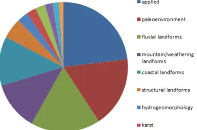
Statistical analysis of 368 papers published in the “Journal of the Korean Geomorphological Association”since its launch in 1994 revealed that the most popular subject is applied geomorphology (85 papers), in which the natural disaster and geomorphol- ogy education are the most. The paleo-environmental reconstruction or Quaternary landscape evolution is the second-most popular topic, of which the number is 65. And sixty-four fluvial landform researches fol- low, and mountain/weathering and coastal landforms equals in numbers, which numbers 45 papers each (Figure 4).
Other papers include three papers on plant geog- raphy, two articles regarding the landforms on Mars and one paper on climatology. <Figure 4> summarizes and shows the classification results for 368 papers published in Journal of the Korean Geomorphological Association by subjects since first publication in 1994.
As was discussed already in Kim’s 2011 paper, poor
Figure 4. Classification results for 368 papers published in Journal of the Korean Geomorphological Association by subjects.
financial support for the geomorphological researches in Korea is partly due to the fact that majority of geog- raphy departments belong to social science division, which slows down the development not only of coastal researches but also geomorphological researches in general which requires relatively large sum of money for the experiments and field surveys. But, continuous participation of geomorphologists in nationwide land- forms survey as a part of “The National Natural En- vironment Survey”, which is initiated and funded by the Ministry of Environment of the Republic of Korea, shall be very helpful to enlist and study the numerous landforms worth of protection.
References
Chang, H., Choi, S. G., Kim, J. Y., and Shin, H. J., 2007, Distributions and ages of the fluvial terraces in the Haseo-cheon (stream) drainage basin in south--cheon (stream) drainage basin in south-cheon (stream) drainage basin in south- (stream) drainage basin in south-stream) drainage basin in south-) drainage basin in south-drainage basin in south- eastern part of the Korean Peninsula, Journal of the Korean Geomorphological Association, 14(1), 1-13 (in Korean).
Choi, K. H., Kim, J. W., Choi, J. H., Byun, J. M., Hong, S. C., Shin, Y. K., and Lee, S. J., 2008, Lumines-. C., Shin, Y. K., and Lee, S. J., 2008, Lumines-C., Shin, Y. K., and Lee, S. J., 2008, Lumines-., Shin, Y. K., and Lee, S. J., 2008, Lumines-Shin, Y. K., and Lee, S. J., 2008, Lumines-, Y. K., and Lee, S. J., 2008, Lumines-Y. K., and Lee, S. J., 2008, Lumines-. K., and Lee, S. J., 2008, Lumines-K., and Lee, S. J., 2008, Lumines-., and Lee, S. J., 2008, Lumines-and Lee, S. J., 2008, Lumines-, S. J., 2008, Lumines-S. J., 2008, Lumines-. J., 2008, Lumines-J., 2008, Lumines-., 2008, Lumines-2008, Lumines-, Lumines-Lumines- cence dating of coastal dune sequences on Wonsan Island and its implications, Journal of the Korean Geomorphological Association, 15(4), 39-51 (in Ko-15(4), 39-51 (in Ko-(4), 39-51 (in Ko-4), 39-51 (in Ko-), 39-51 (in Ko-39-51 (in Ko--51 (in Ko-51 (in Ko- (in Ko-in Ko- rean).
Choi, K. H., Seong, Y. B., Jung P. M. and Lee S. Y., 2012, Using Cosmogenic 10Be dating to unravel the antiquity of a rocky shore platform on the West Coast of Korea, Journal of Coastal Research, 28 (3), 641-657.
Choi, S. G., 2007, Comparison of environmental changes induced by marine and f luvial terraces of the Eastern Coast of Korea with global environmental changes in the Late Pleistocene, Journal of the Ko- rean Geomorphological Association, 14(1), 29-39 (in Korean).
Choi, S.G., and Chang, H., 2008, The chronology of ma-, S.G., and Chang, H., 2008, The chronology of ma-S.G., and Chang, H., 2008, The chronology of ma-.G., and Chang, H., 2008, The chronology of ma-G., and Chang, H., 2008, The chronology of ma-., and Chang, H., 2008, The chronology of ma-and Chang, H., 2008, The chronology of ma-, H., 2008, The chronology of ma-H., 2008, The chronology of ma-., 2008, The chronology of ma-2008, The chronology of ma-, The chronology of ma-The chronology of ma- rine terraces around Uljin area in the mideastern coast of Korea, Journal of the Korean Geomorpho- logical Association, 15(4), 1-15 (in Korean).
Hwang, S. I., and Yoon, S. O., 1998, Natural environ-, S. I., and Yoon, S. O., 1998, Natural environ-S. I., and Yoon, S. O., 1998, Natural environ-. I., and Yoon, S. O., 1998, Natural environ-I., and Yoon, S. O., 1998, Natural environ-., and Yoon, S. O., 1998, Natural environ-and Yoon, S. O., 1998, Natural environ-, S. O., 1998, Natural environ-S. O., 1998, Natural environ-. O., 1998, Natural environ-O., 1998, Natural environ-., 1998, Natural environ-1998, Natural environ-, Natural environ-Natural environ- ment and human activities in Daegu Basin during the prehistoric and ancient times, Journal of the Korean Geographical Society, 33(4), 469-486 (in Korean).
Hwang, S. I., and Yoon, S. O., 2001, The distribution and geomorphic development of alluvial fans along the Bulguksa fault system in Gyeongju and Ulsan City, southeastern Korea, Journal of the Korean Geographical Society, 36(3), 217-232 (in Korean).
Hwang, S. I., and Yoon, S. O., 2011, Holocene climate characteristics in Korean Peninsula with the spe- cial reference to sea level changes, Journal of the Korean Geomorphological Association, 18(4), 235- 246 (in Korean).
Jang, D. H., 2011, Researches on tidal flats in Korea, Jour- nal of the Korean Geomorphological Association, 18(4), 59-78 (in Korean).
Jang, D. H., Kim, M. K., and Kim, G. H., 2003, Change of the sedimentary environment system around the Baramarae Beach, Anmyeondo Area in West Coast of Korea, Journal of the Korean Geomorpho- logical Association, 10(2), 143-155 (in Korean).
Jeon, H. K., and Park, J. K., 2012, Quantitative study on the forms and distributions of Gapyoungchon potholes, Journal of the Korean Geomorphological Association, 18(4), 213-221 (in Korean).
Jeon, Y. G., 2010, Geotourism in Korea, Journal of the Ko- rean Geomorphological Association, 17(4), 53-69 (in Korean).
Kang, T. G., 2011, The studies of the granite landforms in South Korea, Journal of the Korean Geomorphologi- cal Association, 18(4), 1-15 (in Korean).
Kang, Y. P., and Kim, E. J., 2004, Soil characteristic on the fluvial terrace in the basin of Miwoncheon, Journal of the Korean Geomorphological Association, 11(3), 1-12 (in Korean).
Kee, K. D., 2008, The Geomorphological features of
Dongcheon-gugok in the eastern part of Gyeong--gugok in the eastern part of Gyeong-gugok in the eastern part of Gyeong- sang Province, Journal of the Korean Geomorpho- logical Association, 15(2), 95-109 (in Korean).
Kim, C. H., 2011, Applied geomorphology in Korea, Jour- nal of the Korean Geomorphological Association, 18(3), 107-119 (in Korean).
Kim, D., Yu, K. B., and Park, S. J., Identification and vi-, D., Yu, K. B., and Park, S. J., Identification and vi-D., Yu, K. B., and Park, S. J., Identification and vi-., Yu, K. B., and Park, S. J., Identification and vi-Yu, K. B., and Park, S. J., Identification and vi-, K. B., and Park, S. J., Identification and vi-K. B., and Park, S. J., Identification and vi-. B., and Park, S. J., Identification and vi-B., and Park, S. J., Identification and vi-., and Park, S. J., Identification and vi-and Park, S. J., Identification and vi-, S. J., Identification and vi-S. J., Identification and vi-. J., Identification and vi-J., Identification and vi-., Identification and vi-Identification and vi- sualization of complex spatial pattern of coastal dune soil properties using GIS-Based terrain anal--Based terrain anal-Based terrain anal- ysis and geostatistics, Journal of Coastal Research:
Issue 4, supplement, 50 – 60.
Kim J. S., and Jang, D. H., 2011, Time-series analysis of Baramarae beach in Anmyeondo using aerial photographs and field measurement data, Journal of the Korean Geomorphological Association, 18(2), 29-51 (in Korean).
Kim J. S., and Jang, D. H., 2012, Analysing of forest types in Chungnam coastal area using multi-temporal satellite imagery and ASTER DEM Data, Journal of the Korean Geomorphological Association, 19(1), 69-81 (in Korean).
Kim, C. H., 2011, Applied geomorphology in Korea, Jour- nal of the Korean Geomorphological Association, 18(3), 107-119 (in Korean).
Kim, J. Y., 2011, A review and new view on the study on minor erosional forms in bedrock channels in Korea, Journal of the Korean Geomorphological As- sociation, 18(4), 35-57 (in Korean).
Kim, J. Y., 2005, A study on waterfall classification by form and process: focusing on waterfall of Seoracksan, Jeju Island, Hantan River basin, MA Thesis, Sungshin Women’s University.
Kim, J. K., Yang, D. Y., and Kim, J. Y., 2004, The variety of soil erodibility (K-factor) by erosion-plot ex- (K-factor) by erosion-plot ex-K-factor) by erosion-plot ex--factor) by erosion-plot ex-factor) by erosion-plot ex-) by erosion-plot ex-by erosion-plot ex--plot ex-plot ex- periment during rainfall, Journal of the Korean Geomorphological Association, 11(3), 37-46 (in Ko-11(3), 37-46 (in Ko-(3), 37-46 (in Ko-3), 37-46 (in Ko-), 37-46 (in Ko-37-46 (in Ko--46 (in Ko-46 (in Ko- (in Ko-in Ko- rean).
Kim, J. S., and Jang, D. H., 2010, Assessment of fl ood vul-, J. S., and Jang, D. H., 2010, Assessment of fl ood vul-J. S., and Jang, D. H., 2010, Assessment of fl ood vul-. S., and Jang, D. H., 2010, Assessment of fl ood vul-S., and Jang, D. H., 2010, Assessment of fl ood vul-., and Jang, D. H., 2010, Assessment of fl ood vul-and Jang, D. H., 2010, Assessment of fl ood vul-, D. H., 2010, Assessment of fl ood vul-D. H., 2010, Assessment of fl ood vul-. H., 2010, Assessment of fl ood vul-H., 2010, Assessment of fl ood vul-., 2010, Assessment of fl ood vul-2010, Assessment of fl ood vul-, Assessment of fl ood vul-Assessment of flood vul- nerability: Baramarae intertidal area in Anmyeon-: Baramarae intertidal area in Anmyeon-Baramarae intertidal area in Anmyeon- do, Korea, Journal of the Korean Geomorphological Association, 17(2), 29-39 (in Korean).
Kim, J. W., Chang, H. W., Choi, J. H., Choi, K. H., and
Byun, J. M., 2007, Landform characteristics of coastal terraces and optically stimulated lumines- cence dating on the terrace deposits in Yangnam and Yangbuk area of the Gyeongju City, South Korea, Journal of the Korean Geomorphological As- sociation, 14(3), 1-14 (in Korean).
Kim, J. Y., Yang, D. Y., Kim, J. Y., Kim, J. K., Kim, M. S., and Oh, G. C., 2005, A study on the particle size distribution of eroded material from erosion-plot experiments, Journal of the Korean Geomorphologi- cal Association, 12(2), 27-37 (in Korean).
Kim, N. S., and Lee, M. B., 2004, Landform classification using geomorphometric analysis, Journal of the Korean Geomorphological Association, 11(4), 47-60 (in Korean).
Kim, S. H., 2009, The sedimentological environment of deltaic barrier islands in the Nakdong River estu- ary, Journal of the Korean Geomorphological Asso- ciation, 16(4), 119-129 (in Korean).
Kim, S. H., 2012, The coastal geomorphology in general of Korea -research trends and issues-, Journal of the Korean Geomorphological Association, 19(1), 1-15 (in Korean).
Kim, S. H., and Yun, K. S., 2008, The achievement of 2nd natural environment survey in geomorphology part and the direction of 3rd survey, Journal of the Korean Geomorphological Association, 15(4), 75-85 (in Korean).
Kim, T. H., 2009, Geomorphic characteristics of 1100 Highland, and Mulyeongari-oreum, wetlands in Jeju Island, Journal of the Korean Geomorphological Association, 16(4), 35-45 (in Korean).
Kim, T. H., 2011, Volcanic landforms in Korea, Journal of the Korean Geomorphological Association, 18(4), 79-96 (in Korean).
Kim, Y. P., and Im, E. S.,2005, A literature review and analysis on problems of mountain systems in Korean Peninsula, The Korea Spatial Planning Review, 45, 145-163 (in Korean).
Kim, Y. R., 2012, Chemical weathering characteristics of red saprolites at granitic hills in Yeongam, south-, south-south- western Korea, Journal of the Korean Geographical
Society, 47(3), 315-327 (in Korean).
Ko, E. J., and Hong S. J., 1999, Topographical characteris-, E. J., and Hong S. J., 1999, Topographical characteris-E. J., and Hong S. J., 1999, Topographical characteris-. J., and Hong S. J., 1999, Topographical characteris-J., and Hong S. J., 1999, Topographical characteris-., and Hong S. J., 1999, Topographical characteris-and Hong S. J., 1999, Topographical characteris-. J., 1999, Topographical characteris-J., 1999, Topographical characteris-., 1999, Topographical characteris-1999, Topographical characteris-, Topographical characteris-Topographical characteris- tics on the natural landscapes of the western Chri- san area, National Park, Journal of the Association of Korean Photo-Geographers, 10, 1-19 (in Korean).
Kwon, D. H., 2007, Results of the research on Korea’s granite weathering landform and tasks, Journal of the Korean Geomorphological Association, 14(2), 21- 31 (in Korean).
Kwon, D. H., 2009, Applied geomorphology in Korea: re-, D. H., 2009, Applied geomorphology in Korea: re-D. H., 2009, Applied geomorphology in Korea: re-. H., 2009, Applied geomorphology in Korea: re-H., 2009, Applied geomorphology in Korea: re-., 2009, Applied geomorphology in Korea: re-2009, Applied geomorphology in Korea: re-, Applied geomorphology in Korea: re-Applied geomorphology in Korea: re-: re-re- search performance and challenges, Journal of the Korean Geomorphological Association, 16(3), 1-13 (in Korean).
Kwon, H. J., 2000, Mountain Ranges of Korea, Journal of the Korean Geographical Society, 35(3), 389-400 (in Korean).
Lee, E. H., 2011, Floodplain and delta, Journal of the Ko- rean Geomorphological Association, 18(2), 15-23 (in Korean).
Lee, G. R., 2005, Distributional patterns and development factors of fluvial geomorphology in Jucheon River, Central Korea, Journal of the Korean Geomorpho- logical Association, 12(1), 25-34 (in Korean).
Lee, G. R., 2006, Analysis and mapping of geomorpho-, G. R., 2006, Analysis and mapping of geomorpho-G. R., 2006, Analysis and mapping of geomorpho-. R., 2006, Analysis and mapping of geomorpho-R., 2006, Analysis and mapping of geomorpho-., 2006, Analysis and mapping of geomorpho-2006, Analysis and mapping of geomorpho-, Analysis and mapping of geomorpho-Analysis and mapping of geomorpho- logical hazards by severe rain storm during July 14-16, 2006, in Inje-gun, Gangwon-do, Journal of the Korean Geomorphological Association, 13(3), 91- 101 (in Korean).
Lee, G. R., 2011, Researches on fluvial terraces in Korea, Journal of the Korean Geomorphological Association, 18(4), 17-33 (in Korean).
Lee, G. R., and Park, C. S., 2005, The Relations between weathering rind thickness and weathering time for gravel and debris in southern Korea Peninsula, Journal of the Korean Geomorphological Association, 12(3), 13-27 (in Korean).
Lee, M. B., 2010, A Geomorphic surface analysis using remote Sensing in DMZ of Chugaryeong Rift Valley, Central Korea, Journal of the Korean Geo- morphological Association, 17(1), 1-14 (in Korean).
Lee, M. B., Kim, N. S., and Lee, G. R., 2005, Reclama-, M. B., Kim, N. S., and Lee, G. R., 2005, Reclama-M. B., Kim, N. S., and Lee, G. R., 2005, Reclama-. B., Kim, N. S., and Lee, G. R., 2005, Reclama-B., Kim, N. S., and Lee, G. R., 2005, Reclama-., Kim, N. S., and Lee, G. R., 2005, Reclama-Kim, N. S., and Lee, G. R., 2005, Reclama-, N. S., and Lee, G. R., 2005, Reclama-N. S., and Lee, G. R., 2005, Reclama-. S., and Lee, G. R., 2005, Reclama-S., and Lee, G. R., 2005, Reclama-., and Lee, G. R., 2005, Reclama-and Lee, G. R., 2005, Reclama-, G. R., 2005, Reclama-G. R., 2005, Reclama-. R., 2005, Reclama-R., 2005, Reclama-., 2005, Reclama-2005, Reclama-, Reclama-Reclama- tions and coastal changes with case study on
Yeomju and Cheolsan in the West Coast of North Korea, Journal of the Korean Geomorphological As- sociation, 12(3), 99-110 (in Korean).
Lee, S. B., Lee, Y. I., and Kim, J. W., 2003, Jangsan-ri ter-, S. B., Lee, Y. I., and Kim, J. W., 2003, Jangsan-ri ter-S. B., Lee, Y. I., and Kim, J. W., 2003, Jangsan-ri ter-. B., Lee, Y. I., and Kim, J. W., 2003, Jangsan-ri ter-B., Lee, Y. I., and Kim, J. W., 2003, Jangsan-ri ter-., Lee, Y. I., and Kim, J. W., 2003, Jangsan-ri ter-Lee, Y. I., and Kim, J. W., 2003, Jangsan-ri ter-, Y. I., and Kim, J. W., 2003, Jangsan-ri ter-Y. I., and Kim, J. W., 2003, Jangsan-ri ter-. I., and Kim, J. W., 2003, Jangsan-ri ter-I., and Kim, J. W., 2003, Jangsan-ri ter-., and Kim, J. W., 2003, Jangsan-ri ter-and Kim, J. W., 2003, Jangsan-ri ter-, J. W., 2003, Jangsan-ri ter-J. W., 2003, Jangsan-ri ter-. W., 2003, Jangsan-ri ter-W., 2003, Jangsan-ri ter-., 2003, Jangsan-ri ter-2003, Jangsan-ri ter-, Jangsan-ri ter-Jangsan-ri ter--ri ter-ri ter- race: the pre-lava flow fluvial terrace in the Imjin River basin, Journal of the Korean Geomorphologi- cal Association, 10(1), 19-32 (in Korean).
Lee, Y. H., and Jo, W. R., 2005, Landforms and grain size analysis of Bupseong-Bay tidal flats, Journal of the Korean Geomorphological Association, 12(1), 63-76 (in Korean).
Munyikwa, K., Choi, K. H., Choi, J. H., Park, K., and Kim, J. W., 2005, The sedimentology and lumi-, J. W., 2005, The sedimentology and lumi-J. W., 2005, The sedimentology and lumi-. W., 2005, The sedimentology and lumi-W., 2005, The sedimentology and lumi-., 2005, The sedimentology and lumi-2005, The sedimentology and lumi-, The sedimentology and lumi-The sedimentology and lumi- nescence chronology of a coastal dune sequence at Unyo Beach, T`aean-Gun, Journal of the Korean Geomorphological Association, 12(1), 161-178 (in Korean).
Munyikwa, K., Choi, J. H., Choi, K. H., Byun, J. M., Kim, J. W., and Park, K., 2008, Coastal dune lumines-. W., and Park, K., 2008, Coastal dune lumines-W., and Park, K., 2008, Coastal dune lumines-., and Park, K., 2008, Coastal dune lumines-and Park, K., 2008, Coastal dune lumines-, K., 2008, Coastal dune lumines-K., 2008, Coastal dune lumines-., 2008, Coastal dune lumines-2008, Coastal dune lumines-, Coastal dune lumines-Coastal dune lumines- cence chronologies indicating a Mid-Holocene highstand along the East Coast of the Yellow Sea, Journal of Coastal Research, 24(2B), 92-103.
Oh, K. S., 1996, Reflection and perspective of the geo-, K. S., 1996, Reflection and perspective of the geo-K. S., 1996, Reflection and perspective of the geo-. S., 1996, Reflection and perspective of the geo-S., 1996, Reflection and perspective of the geo-., 1996, Reflection and perspective of the geo-1996, Reflection and perspective of the geo-, Reflection and perspective of the geo-Reflection and perspective of the geo- morphology in Korea, 31(2), Journal of the Korean geographical Society, 106-127 (in Korean).
Park, D. W., Oh, N. S., and Park, S. P., 1984, Geomor-, D. W., Oh, N. S., and Park, S. P., 1984, Geomor-D. W., Oh, N. S., and Park, S. P., 1984, Geomor-. W., Oh, N. S., and Park, S. P., 1984, Geomor-W., Oh, N. S., and Park, S. P., 1984, Geomor-., Oh, N. S., and Park, S. P., 1984, Geomor-Oh, N. S., and Park, S. P., 1984, Geomor-, N. S., and Park, S. P., 1984, Geomor-N. S., and Park, S. P., 1984, Geomor-. S., and Park, S. P., 1984, Geomor-S., and Park, S. P., 1984, Geomor-., and Park, S. P., 1984, Geomor-and Park, S. P., 1984, Geomor-, S. P., 1984, Geomor-S. P., 1984, Geomor-. P., 1984, Geomor-P., 1984, Geomor-., 1984, Geomor-1984, Geomor-, Geomor-Geomor- phology or Gapado and Marado islets, Jejudo Re-, Jejudo Re-Jejudo Re- search, 1, 365-382 (in Korean).
Park, E. J., 2001, A study on sedimentary environment of intertidal region according to surface sediment analysis, Journal of the Korean Geomorphological Association, 8(1), 15-26 (in Korean).
Park, H. D., 2011, The canal of China, Northern Europe and the Pan-Korea Grand waterway development, Journal of the Korean Geomorphological Association, 18(1), 15-27 (in Korean).
Park, J. H., 2011, The Quaternary environmental research trend of the Korea and future issues - focused on Last Interglacial~Holocene environmental study of physical geographers-, Journal of the Korean Geomorphological Association, 18(4), 97-126 (in Korean).