A THESIS
FOR THE DEGREE OF DOCTOR OF PHILOSOPHY
LOCATION-AWARE ROUTING AND GEOCASTING
IN WIRELESS AD HOC NETWORKS
FARRUKH ASLAM KHAN
Department of Computer Engineering
GRADUATE SCHOOL
CHEJU NATIONAL UNIVERSITY
August 2007
Location-Aware Routing and Geocasting in
Wireless Ad hoc Networks
Farrukh Aslam Khan
(Supervised by Professor Wang-Cheol Song)
A thesis submitted in partial fulfillment of the requirements for the degree
of Doctor of Philosophy in Computer Engineering
2007. 8.
The thesis has been examined and approved.
___________________________________________________ Thesis Committee Chair
Khi-Jung Ahn, Professor, Cheju National University ___________________________________________________
Do-Hyun Kim, Associate Professor, Cheju National University ___________________________________________________
Jitae Shin, Assistant Professor, Sungkyunkwan University ___________________________________________________
Deokjai Choi, Professor, Chonnam National University ___________________________________________________
Thesis Supervisor
Wang-Cheol Song, Professor, Cheju National University
Department of Computer Engineering
GRADUATE SCHOOL
To
My Parents
ACKNOWLEDGEMENTS
First of all, I offer my humble thanks to God Almighty for giving me strength to finish my doctoral studies successfully. Many praises be to Prophet Muhammad (pbuh) who taught and emphasized the importance of learning and seeking knowledge. I am extremely grateful to my advisor Prof. Wang-Cheol Song for his guidance and support during my studies in Cheju National University. Without his help, constant interaction, helpful discussions and keen interest, this thesis would not have been possible. I would like to extend my sincere gratitude towards Prof. Khi-Jung Ahn for his always encouraging and motivating behavior, guidance, invaluable advices, and extremely helpful attitude. I feel proud to have worked with such a kind and knowledgeable professor. Thank you Sir.
I wish to offer my humble gratitude to Prof. Do-Hyun Kim, Prof. Jitae Shin (Sungkyunkwan University) and Prof. Deokjai Choi (Chonnam National University) for their useful suggestions and extremely important comments during the process of my thesis evaluation. I am also grateful to other professors of my department: Prof. Jang-Hyung Kim, Prof. Sang-Young Byun, Prof. Ho-Young Kwak, Prof. Sang-Joon Lee, and Prof. Young-Cheol Byun for their encouragement and guidance during my studies.
I also want to extend my thanks to Prof. Kyung-Youn Kim (Dept. of Electronic Engineering), Prof. Min-Jae Kang (Dept. of Electronic Engineering), Prof. Sin Kim (Dept. of Nuclear and Energy Engineering), and Prof. Gyung-Leen Park (Dept. of Computer Science and Statistics) for their help and guidance throughout my stay in Cheju National University.
Sincere thanks to our department secretaries, Jung-ha Lee and Eun-Gyung Jung for all their help and assistance. I greatly acknowledge my current and ex-lab. members: Kyung-Jin Lee, Jung-Youn Lee, Gang-Seok Kim, Jee-Wan Huh, Sung-Soo Kim, Hyun-Seok Choi, and Chung-Joon Kim, for their enormous help and co-operation. I am extremely grateful to my lab-mate Shafqat-ur-Rehman for all his help during the final year of my PhD studies. I also appreciate the help of Dr. Kyoung-Bok Han and Dong-Kyun Han for helping me in thesis publishing and binding process.
I want to express my sincere thanks to my friend and colleague Umer Zeeshan Ijaz for all his help and company during my studies. I really enjoyed the long discussion sessions with him on all topics in front of the coffee vending machine in our building. I also greatly acknowledge all my friends in Cheju National University especially Guan-Seok Kang, Chul-hong Oh, Li Ying, Anil Kumar, Anji Reddy, Jasim Uddin and Abhijit Saha for all their support and company.
I offer my special thanks to Dr. Abu Affan and his family who have been very kind and supportive to me in all circumstances since the beginning of my stay in Korea. I greatly value the time I spent with them.
I am highly indebted to my teachers in Pakistan, Dr. Mahboob Yasin and Dr. Anwar Majid Mirza for their encouragement, support and guidance during my studies. Many thanks and regards to Mary D. Branson and Mee-Sun Kim for all their help and assistance during my early days in Korea. I want to thank all those who prayed for me, helped and supported me in numerous ways during the period of my studies in Korea. I greatly acknowledge the Institute for Information Technology Advancement (IITA) for granting me scholarship to carry out my PhD studies.
Finally, I present my profound thanks and regards to my parents, who have a great impact on my life and who have always been a great source of inspiration for me. They taught me patience, perseverance, honesty, courage and the importance of learning and acquiring knowledge. Without their prayers, love, guidance and support, any of my achievements would not have been possible. I also express my deepest and sincere gratitude to my brother Adeel and his wife, my youngest brother Zeshan, my sister Sadaf, her husband Tahir and their children, who have always supported me with their prayers, love and best wishes for all my struggles and endeavors.
Farrukh Aslam Khan July 2007
ABSTRACT
This thesis is primarily concerned with two main topics in wireless ad hoc networks: location-aware routing and geocasting. First, a new location-aware routing protocol called Location-aware Grid-based Hierarchical Routing (LGHR) protocol is proposed for mobile ad hoc networks that attempts to reduce the overhead generated by other protocols falling in the same category. In LGHR, the network area is divided into non-overlapping zones. A hierarchy is established in such a manner that the whole network is partitioned into zones and each zone is then further divided into smaller regions called grids. A centralized approach is used within each zone and grid. A leader is elected from each zone whereas a central node called gateway is elected from each smaller grid. The leader is responsible for making routing tables which then sends these tables to the respective gateways. Both intra-zone and inter-zone routing mechanisms are explained. The proposed protocol is compared with other location-aware routing protocols known as Zone-based Hierarchical Link State (ZHLS) and GRID. ZHLS which is also a hierarchical protocol uses link state routing in each zone. Each node in a zone sends its link state packets to all other nodes in its zone. Hence, each node stores and makes its intra-zone and inter-zone routing tables causing huge communication overhead in case there are large numbers of nodes in a zone. The proposed protocol LGHR reduces the communication and storage overhead by further partitioning each zone into smaller grids. Unlike ZHLS, only gateway nodes keep the routing tables and routing is performed in a gateway-by-gateway manner. In order to compare both protocols, the mathematical analysis is done for both ZHLS and LGHR and then evaluation is performed. The analysis clearly indicates that the proposed protocol performs better than ZHLS in terms of the storage overhead as well as communication overhead generated by all nodes. The protocol is also compared with another location-aware protocol called GRID. The stability factor is analyzed by doing simulations for both protocols. The stability factor is chosen on the basis of gateway election mechanisms. GRID uses only the distance from the center of the grid for electing a gateway whereas LGHR takes into account the velocity of a node along with the distance form the center of the grid. The simulation
results clearly show that the proposed protocol LGHR is more stable than GRID especially in scenarios where the wireless nodes are moving with very high velocity.
The second topic discussed in the dissertation is the problem of guaranteeing the delivery of geocast packets to all nodes inside a geocast region for wireless ad hoc networks. The nodes in the geocast region may not be directly connected to one another, causing isolated groups of nodes that do not have direct access to some other nodes within a geocast region. These isolated groups of nodes are named as islands. In order to ensure the delivery of packets to all nodes, a geocasting protocol called Grid-based Guaranteed Geocast (GGG or G3) is proposed that uses the nodes outside the geocast region to deliver packets to these islands. Several nodes outside the geocast region can have direct connections with islands, but only one node is elected called Main Entry Point (MEP) which is responsible for delivering the packets to the nodes inside the geocast region. This helps in avoiding duplicate packets entering the geocast region. Also, the concept of location server is redefined and is given the routing responsibilities as well. Simulations are performed to compare the proposed mechanism with two other geocasting protocols, LBM and GAMER. The simulations prove that the proposed mechanism not only guarantees the delivery of geocast packets but also performs better than the other two protocols, LBM and GAMER in terms of throughput, end-to-end delay, packet delivery ratio and data packet overhead.
요 약 문
본 논문은 무선 Ad hoc 네트워크에 관련된 두 가지 주된 라우팅 알고리즘 중 위치 인지 라우팅과 geocasting 에 관해 연구하였다.
첫째로, 무선 Ad hoc 네트워크를 위해 LGHR (Location-aware Grid-based Hierarchical Routing)이라고 불리는 새로운 위치 인지 라우팅 프로토콜을 제안하여 같은 범주 내의 다른 알고리즘들 에서 발생되는 오버헤드를 감소시키고자 하였다. LGHR 에서 네트워크 영역은 겹치지 않는 존 들로 분리되어져 있다. 하나의 그룹은 전체 네트워크에서 존 들로 분할되어지고, 각각의 존 들은 그리드 라고 불리는 더 좁은 영역들로 나누어지는 방식으로 이루어져 있다. 각각의 존과 그리드 내에서는 중앙집중형 접근방식이 사용되어지고 있다. 각각의 존으로부터 하나의 리더가 선택되며 각각의 그리드로부터는 게이트웨이라 불리는 중심 노드들이 선택된다. 각 리더는 라우팅 테이블을 구성할 책임이 있으며 이는 이후 게이트웨이들에게 보내져 존 내 혹은 존 간 라우팅 기법을 위하여 사용된다. 제시된 LGHR 프로토콜은 ZHLS와 GRID로 알려진 다른 위치 인지 라우팅 프로토콜들과 비교하였다. ZHLS 역시 각각의 존 에서 링크 상태 라우팅을 사용하는 계층형 프로토콜이다. 존 안에 있는 각각의 노드들은 그 존 내의 모든 다른 노드들에게 LSP (Link State Packet) 들을 보내며 각각의 노드들은 존 내 또는 존 간의 경로배정표를 저장하여 라우팅 동작을 수행하게된다. 따라서 존 내에 많은 노드들이 있을 경우 매우 많은 통신 오버헤드가 발생하게 된다. 본 논문에서 제시된 프로토콜인 LGHR은 더 작은 그리드들로 각각의 존을 분할 함으로써 통신 오버헤드와 저장 오버헤드를 감소시키고자 하였다. ZHLS와는 달리, 게이트웨이 노드들만이 라우팅 테이블들을 유지하게 되고 실제적인 전송은 gateway-by-gateway 방식으로 수행된다. 각 프로토콜들의 비교를 위해 ZHLS와 LGHR에 대한 수학적 분석을 수행한 후 성능 분석을 하였다. 제안된 프로토콜은 모든 노드들에 의해 발생하는 통신 오버헤드 뿐만 아니라 저장
오버헤드 관점에서도 ZHLS 보다 더 우수한 특성을 보이고 있다. 또한 제안한 프로토콜은 GRID로 불리는 위치 인지 프로토콜과도 비교되어졌으며 게이트웨이 선출 기법들을 기반으로 안정성 요소들에 대하여도 분석이 이루어졌다. GRID는 하나의 게이트웨이 선정을 위해 단지 그리드의 중심으로부터의 거리만을 사용하는 반면 LGHR은 그리드의 중심으로부터의 거리는 물론 노드에 따른 이동속도를 이용하고 있다. 시뮬레이션 결과 무선 노드들이 매우 빠른 속도로 움직이는 경우 LGHR이 GRID 기법보다 더 안정적으로 동작함을 명확하게 보여주고있다. 본문에서 다루어진 두 번째 주제는 무선 Ad hoc 네트워크에서 모든 노드들이 하나의 geocast 영역 안으로 geocast 패킷 전달을 보장하는 문제에 대한 것이다. Geocast 영역 안에 있는 일부 노드들은 같은 영역 내의 다른 노드들에 직접적으로 접근하지 못하는 경우가 발생하는데 이들 노드들의 분리된 그룹을 Islands 이라 한다. Geocast 영역 내의 모든 노드들에게 패킷들의 전달을 보장하기 위하여 G3 (Grid-based Guaranteed Geocast) 라고 불리는 geocasting 프로토콜이 제시 하였으며, 여기에서는 Island들에게 패킷들을 전달하기 위해 geocast 영역 바깥 쪽 노드들을 사용하였다. Geocast 영역 밖의 몇몇 노드들은 Island들에게 직접적으로 연결될 수 있지만 이들 중 Main Entry Point (MEP) 라고 불리는 하나의 노드만이 선택 되어 패킷전달역할을 수행하게된다. 이와같은 MEP들은 geocast 영역 안쪽 노드들에게 패킷들을 전달할 책임을 가지고 있으며 geocast 영역 안으로 중복적인 패킷 전송을 피할 수 있도록 하고있다. LS(위치기반 서버) 의 개념 또한 새롭게 정의 되어졌으며 경로배정의 역할을 수행하여야 할 책임이 있다. 제안된 기법의 성능 평가를 위하여 두 가지 다른 LBM과 GAMER를 가지고 시뮬레이션을 수행하여 비교하였다. 제안된 기법이 geocast 패킷들의 전달을 보장함은 물론 처리율, 종단간의 지연, 패킷 전달율과 데이터 패킷 오버헤드에 대해서도 다른 두 프로토콜 (LBM, GAMER)들 보다는 더 나은 성능을 지니고 있음을 시뮬레이션을 통해 검증하였다.
TABLE OF CONTENTS
I INTRODUCTION ... 1
1.1 Location-aware Routing Protocol... 2
1.2 Geocasting with Delivery Guarantee ... 4
1.3 Organization of the Dissertation ... 5
II RELATED WORK ... 7
2.1 Ad hoc Routing Protocols... 7
2.2 Location-aware Routing Protocols ... 10
2.2.1 Location-Aided Routing Protocol (LAR) ... 10
2.2.2 GRID protocol... 12
2.2.3 Greedy Perimeter Stateless Routing (GPSR)... 15
2.2.4 Zone-based Hierarchical Link State (ZHLS)... 15
2.3 Geocasting Protocols for Ad hoc Networks... 17
2.3.1 Topology-based Geocasting protocols... 18
2.3.1.1 Location-Based Multicast (LBM) ... 18
2.3.1.2 GeoGRID ... 19
2.3.1.3 Geocast Adaptive Mesh Environment for Routing (GAMER)... 20
2.3.2 Face Traversal based Geocasting protocols ... 22
2.3.2.1 Geographic Forwarding Perimeter Geocast (GFPG) ... 22
2.3.2.2 Restricted Flooding with Intersected Face Traversal (RFIFT)... 23
III LOCATION-AWARE GRID-BASED HIERARCHICAL ROUTING IN MOBILE AD HOC NETWORKS ... 25
3.1 Introduction... 26
3.2 Location-Aware Grid-based Hierarchical Routing Protocol... 28
3.2.1 The Network Layout ... 28
3.2.1.1 The Zone Size ... 29
3.2.2 The Leader Node ... 30
3.2.2.1 The Leader Region ... 31
3.2.2.2 Leader Election... 33
3.2.3 The Gateway Node ... 35
3.2.3.1 Gateway Election... 36
3.3 Zone Discovery and Basic Routing Mechanism... 41
3.3.1 Intra-zone Routing ... 41
3.3.2 Inter-zone Routing ... 43
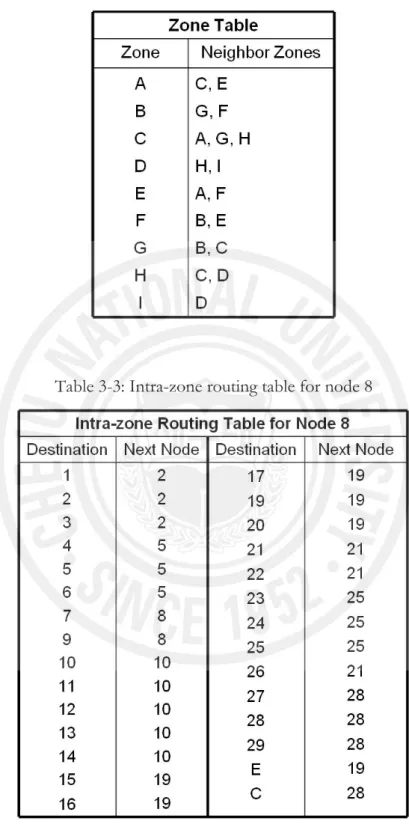
3.4 Example Scenarios ... 45
3.4.1 Routing Table Construction ... 47
3.4.2 Analyzing the Routing Entries ... 49
IV ANALYSIS AND EVALUATION OF LGHR... 54 4.1 Comparison with ZHLS... 54 4.1.1 Mathematical Analysis ... 54 4.1.1.1 Storage Overhead ... 55 4.1.1.2 Communication Overhead... 58 4.1.2 Evaluation ... 61 4.1.2.1 Storage Overhead ... 61 4.1.2.2 Communication Overhead... 72
4.2 Comparison with GRID Protocol ... 76
4.2.1 Effect of Velocity ... 77
4.2.2 Effect of Number of Nodes ... 78
4.2.3 Effect of Grid Size ... 80
4.2.4 Effect of Simulation Time ... 81
4.3 Summary ... 82
V GEOCASTING IN WIRELESS AD HOC NETWORKS WITH GUARANTEED DELIVERY ... 84
5.1 Introduction... 84
5.2 Motivation of Proposed Protocol... 86
5.3 Proposed Mechanism ... 89
5.3.1 Layout of the Network ... 90
5.3.2 Geocasting Mechanism... 92
5.3.3 The Leader Election ... 94
5.3.4 Main Entry Points (MEPs) ... 95
5.4 Maintenance of Geocast Region... 97
5.4.1 Merging of Two Islands... 97
5.4.2 Partitioning of Islands ... 98
5.5 Analysis and Discussion ... 99
5.6 Summary ... 102
VI EVALUATION OF GRID-BASED GUARANTEED GEOCAST PROTOCOL... 104 6.1 Simulations... 104 6.1.1 Simulation Model ... 105 6.1.2 Simulation Results ... 106 6.1.2.1 Delivery Guarantee... 106 6.1.2.2 Throughput ... 107 6.1.2.3 Communication Overhead... 108 6.1.2.4 End-to-End Delay ... 109
6.1.2.5 Packet Delivery Ratio... 110
6.2 Summary ... 111
VII CONCLUSION AND FUTURE DIRECTIONS... 112
LIST OF FIGURES
Figure 2.1: Classification of ad hoc routing protocols... 9
Figure 2.2: In LAR scheme 1, the packet is flooded only in the Request Zone. ... 11
Figure 2.3: In LAR scheme 2, the packet is forwarded only if the distance of current node is shorter than the previous one. ... 12
Figure 2.4: Routing operation in GRID is performed in a grid-by-grid manner. ... 14
Figure 2.5: (a) Node level topology (b) Zone level topology. ... 17
Figure 2.6: Flooding-based GeoGrid operation. ... 20
Figure 2.7: GAMER with FLOOD Forwarding Approach where the forwarding zone is the whole network. The filled rectangular area is the geocast region... 21
Figure 2.8: GAMER with CORRIDOR Forwarding Approach... 21
Figure 2.9: GAMER with CONE Forwarding Approach. ... 22
Figure 3.1: The network is divided into zones and each zone is further divided into smaller grids. Each grid can have a gateway node which is elected according to the gateway election procedure. ... 29
Figure 3.2: The size length ‘d’ of each side of a grid. ... 30
Figure 3.3: The leader moving outside the leader region is still able to access the nodes near the center of the zone asking them to initiate leader election procedure again. ... 32
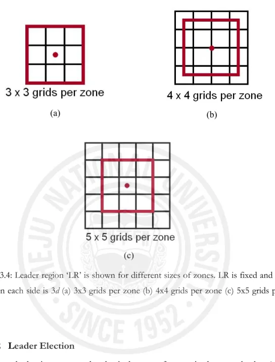
Figure 3.4: Leader region ‘LR’ is shown for different sizes of zones. LR is fixed and its value on each side is 3d (a) 3x3 grids per zone (b) 4x4 grids per zone (c) 5x5 grids per zone ... 33
Figure 3.5: Leader announcement packet. ... 35
Figure 3.6: Two adjacent zones where the shaded grid contains the Edge Gateway nodes whereas the white grids have Intermediate Gateway nodes. ... 36
Figure 3.7: Two angles θ1 and θ2 are needed in order to calculate the direction of a moving node... 40
Figure 3.8: Intra-zone routing mechanism; filled black circles are gateway nodes whereas unfilled circles are non-gateway nodes. Routing is performed in a gateway-by-gateway manner. ... 42 Figure 3.9: Local topology inside zone A for the example. The connectivity of gateway
nodes with other gateways is shown with solid lines... 48 Figure 3.10: Complete inter-zone topology for the example scenario. The dotted line
shows the connectivity among different zones. ... 48 Figure 4.1: Comparison of LGHR with ZHLS in terms of number of entries stored for a
network of 1000 nodes having 9 zones in the network. The values are shown for 9 gateways per zone. Hence, the total number of gateways in the whole network becomes 81. ... 62 Figure 4.2: Comparison of LGHR with ZHLS in terms of number of entries stored for a
network of 1000 nodes having 9 zones in the network. The values are shown for 16 gateways per zone. Hence, the total number of gateways in the whole network becomes 144. ... 63 Figure 4.3: Comparison of LGHR with ZHLS in terms of number of entries stored for a
network of 1000 nodes having 9 zones in the network. The values are shown for 25 gateways per zone. Hence, the total number of gateways in the whole network becomes 225. ... 64 Figure 4.4: Comparison of LGHR with ZHLS in terms of number of entries stored for a
network of 1000 nodes having 16 zones in the network. The values are shown for 9 gateways per zone. Hence, the total number of gateways in the whole network becomes 144... 65 Figure 4.5: Comparison of LGHR with ZHLS in terms of number of entries stored for a
network of 1000 nodes having 16 zones in the network. The values are shown for 16 gateways per zone. Hence, the total number of gateways in the whole network becomes 256... 66 Figure 4.6: Comparison of LGHR with ZHLS in terms of number of entries stored for a
network of 1000 nodes having 16 zones in the network. The values are shown for 25 gateways per zone. Hence, the total number of gateways in the whole network becomes 400... 67
Figure 4.7: Comparison of LGHR with ZHLS in terms of number of entries stored for a network of 1000 nodes having 25 zones in the network. The values are shown for 9 gateways per zone. Hence, the total number of gateways in the whole network becomes 225... 68 Figure 4.8: Comparison of LGHR with ZHLS in terms of number of entries stored for a
network of 1000 nodes having 25 zones in the network. The values are shown for 16 gateways per zone. Hence, the total number of gateways in the whole network becomes 400... 69 Figure 4.9: Comparison of LGHR with ZHLS in terms of number of entries stored for a
network of 1000 nodes having 25 zones in the network. The values are shown for 25 gateways per zone. Hence, the total number of gateways in the whole network becomes 625... 70 Figure 4.10: Comparison of LGHR with ZHLS in terms of number of entries stored for
a network of 2000 nodes having 25 zones in the network. The values are shown for 16 gateways per zone. Hence, the total number of gateways in the whole network becomes 400... 71 Figure 4.11: Comparison of LGHR with ZHLS in terms of number of entries stored for
a network of 2000 nodes having 25 zones in the network. The values are shown for 25 gateways per zone. Hence, the total number of gateways in the whole network becomes 625... 72 Figure 4.12: Communication overhead for topology creation generated by both LGHR
and ZHLS protocols in case of 9 zones in the network... 73 Figure 4.13: Communication overhead for topology creation generated by both LGHR
and ZHLS protocols in case of 16 zones in the network. ... 74 Figure 4.14: Communication overhead for topology creation generated by both LGHR
and ZHLS protocols in case of 25 zones in the network. ... 75 Figure 4.15: Comparison of LGHR and GRID in terms of velocity of mobile nodes.... 78 Figure 4.16: Comparison of LGHR and GRID in terms of number of nodes in a grid.. 79 Figure 4.17: Comparison of LGHR and GRID in terms of grid size. ... 81 Figure 4.18: Comparison of LGHR and GRID in terms of simulation time. ... 82 Figure 5.1: Nodes at top right and left corners are unable to receive geocast packets. ... 87
Figure 5.2: (a) The size of the each grid is such that a node from anywhere in the grid can access all its neighboring grids (b) A node is able to access all its horizontal and vertical neighbors from anywhere inside a grid, but it will not be able to access all nodes in the diagonal grids... 91 Figure 5.3: Layout of the network that is partitioned into equal-sided grids. Each grid has
a leader node which maintains the connectivity information of all its
neighboring grids. ... 91 Figure 5.4: Geocasting mechanism with single island case. Node S is the source node
whereas Node M is the MEP. Shaded grids show the connectivity among grids... 92 Figure 5.5: Geocasting mechanism with multiple islands case. Node S is the source node
whereas Nodes M1 and M2 are two MEPs. Shaded grids show the
connectivity among grids. ... 93 Figure 5.6: LEADER-ANNOUNCE packet... 95 Figure 5.7: Each island A, B, C, D and E has one MEP which is responsible for
delivering packets inside the geocast region... 97 Figure 5.8: Merging of two islands... 98 Figure 5.9: Partitioning of an island into two... 98 Figure 5.10: (a) One island in the geocast region (b) Four islands in the geocast region
each is having one MEP... 99 Figure 5.11: By increasing the number of islands result in increased number of MEPs
until they start merging at some point. (a) 4 islands with 4 MEPs (b) 8 islands with 8 MEPs... 100 Figure 5.12: Effect on number of MEPs by increasing the number of islands. ... 102 Figure 6.1: Comparative throughput for three protocols, LBM, GAMER and GGG. . 107 Figure 6.2: The communication overhead for LBM, GAMER and GGG... 109 Figure 6.3: Total End-to-End delay experienced by LBM, GAMER and GGG... 110 Figure 6.4: Packet delivery ratio for LBM, GAMER and GGG... 111
LIST OF TABLES
Table 2-1: A few example ad hoc routing protocols ... 9
Table 3-1: Neighbor table for all nodes in the example ... 50
Table 3-2: Zone table for all connected zones in the network ... 51
Table 3-3: Intra-zone routing table for node 8 ... 51
Table 3-4: Inter-zone routing table maintained by node 17 ... 52
Table 3-5: Entries stored by each node and all nodes in a zone in ZHLS ... 52
Table 3-6: Entries stored by leader node and all one gateway nodes in one zone in LGHR ... 52
Table 5-1: Leader table stored by the location server containing information about all the leaders and their connected grids. ... 95
Table 5-2: The effect of number of MEPs by increasing the number of islands in the geocast region. Maximum number of islands possible is 4... 101
Table 5-3: The effect of number of MEPs by increasing the number of islands in the geocast region. Maximum number of islands possible is 8... 101
Table 6-1: Simulation parameters ... 105
Chapter 1
INTRODUCTION
Mobile ad hoc networks started gaining popularity since 1990s and there has been a rapid growth of interest by researchers in this field. More specifically, people are interested in routing in ad hoc networks and several routing protocols have been added into the literature. Generally, ad hoc routing protocols can be classified into three major categories: pro-active, reactive and hybrid routing protocols. All these three kinds of routing protocols can be either flat or hierarchical. Moreover, these routing protocols can be location-aware or location-unaware. A detailed review of ad hoc routing protocols can be found in Abolhasan et al. (2004). Location-aware routing (also called position-based routing or geographic routing) is a phenomenon in which the physical location of nodes is utilized for delivering a message from one node to another. The location information can be taken either with the help of a GPS (Grewal et al., 2001) receiver or some other positioning method. Several techniques have been proposed by researchers for GPS-free positioning(Capkun et al., 2001) or positioning based on virtual co-ordinates (Caruso et al., 2005; Rao et al., 2003). Moreover, several location-based routing protocols for mobile ad hoc and sensor networks have been proposed by authors during the past few years (Basagni et al., 1998; Fang et al., 2005; Joa-Ng and Lu, 1999; Ko and Vaidya, 2000a; Liao et al., 2001). Majority of these protocols base their routing decisions entirely on the physical locations of nodes whereas some of them partially utilize the location information for routing.
In this thesis, two main topics are discussed. First, a location-aware routing protocol called Location-aware Grid-based Hierarchical Routing (LGHR) is proposed that attempts to reduce the overhead generated by some of the other ad hoc routing protocols. Secondly, the problem of guaranteeing the delivery of packets to all nodes in a geocast region is addressed. For this purpose, a geocasting protocol
called Grid-based Guaranteed Geocast (GGG or G3) is proposed and is compared with some other existing geocasting protocols.
1.1 Location-aware Routing Protocol
The main purpose of the proposed location-aware routing protocol is to reduce the drawbacks of some of the existing routing protocols. A hierarchical routing protocol called Location-aware Grid-based Hierarchical Routing (LGHR) is proposed for mobile ad hoc networks which uses non-overlapping zones for efficient routing. The hierarchy is made in such a way that the network is partitioned into zones and each zone is then further divided into smaller grids. Moreover, each zone has a node called leader which is responsible for maintaining routing tables and making routing decisions. Each smaller grid in a zone has a gateway node which is responsible for its own grid. The leader sends the routing tables to respective gateway nodes present in its zone. On the basis of these routing tables, the gateway nodes forward packets to other nodes. LGHR is compared with another hybrid zone-based routing protocol called Zone-zone-based Hierarchical Link State (ZHLS) (Joa-Ng and Lu, 1999). ZHLS tries to reduce the overhead of the traditional Link State Routing by dividing the whole network into zones. Moreover, ZHLS is a hybrid pro-active/reactive protocol for which the pro-active link state routing is performed within a zone and a reactive zone search strategy is initiated if a node wants to send a packet to a node in another zone. A node can know its position with the help of a GPS receiver and hence, can easily figure out which zone it lies in.
A major problem with ZHLS is that if there are large numbers of nodes present in a zone, every node in a zone has to store all the routing information for all nodes. This includes the link state packets periodically exchanged by all nodes as well as the intra-zone and inter-zone routing tables. Since, in ad hoc networks, the nodes can be mobile and can move frequently in the network, the nodes have to send their neighbor connectivity information very often. Therefore, the network’s bandwidth is mostly utilized by bombarding the link state packets in the network resulting in huge
communication overhead. As mentioned, the protocol initiates a reactive zone search mechanism if the destination node lies outside the current source’s zone. Since almost all location-based routing protocols use a location service to determine the position of the destination, this problem could be easily solved by fully utilizing the location-aware capability of the protocol i.e., it could use the zone map for mapping the destination’s position and find out which zone the destination lies in. This way, a lot of extra communication overhead induced by initiating the zone search mechanism could be reduced.
The proposed protocol solves the above-mentioned problems by assigning the routing table creation responsibilities to a centralized node within a zone called leader. The neighbor information is sent by nodes to only the leader, not to all the other nodes in a zone. On the basis of this neighbor information, the leader constructs the routing tables. Moreover, all nodes are not supposed to carry the routing tables and perform the routing operations. Since, each zone is further divided into smaller grids and each grid has a responsible node called gateway, all the routing is performed in a gateway-by-gateway manner. The leader sends the routing tables to respective gateway nodes and hence, only the gateway nodes are responsible for packet forwarding. Non-gateway nodes do not participate in the packet forwarding process. This approach avoids a lot of extra communication and storage overhead which could be caused by using a peer-to-peer approach as in ZHLS.
LGHR uses pro-active mechanism inside a zone but unlike ZHLS, it does not initiate a reactive zone search mechanism if the destination lies outside the zone of the source node. Instead, it uses the location-based strategy to identify the destination’s zone by mapping the position of the destination on the zone map. Both protocols are analyzed and it is shown that the proposed protocol LGHR is efficient and performs better than ZHLS in terms of amount of routing information stored as well as the communication overhead generated by various nodes.
LGHR is also compared with another location-aware ad hoc routing protocol called GRID (Liao et al., 2001). GRID is a fully location-aware reactive routing protocol which also uses non-overlapping grids and nodes in a grid elect a gateway
node in which the routing is performed in a grid-by-grid manner. Stability of both protocols is analyzed and the frequency of gateway election mechanisms is used as a parameter for stability. GRID uses only the distance from the center of the grid as a criterion for electing a gateway, whereas, LGHR takes into account the distance from the center as well as the velocity of mobile nodes in order to elect a gateway. The performance comparison shows that LGHR tends to work in a more stable manner than the GRID protocol especially in situations of high mobility.
1.2 Geocasting with Delivery Guarantee
Geocasting is a phenomenon in which a packet is supposed to be sent to all the nodes inside a physical region. Guaranteed delivery means the ability of successfully forwarding a message from a source node to the destination. The definition requires that source and destination are connected by at least one path in the network and that there is an idealized MAC layer where messages are not lost during any forwarding step (Stojmenovic, 2006). In case of geocasting, the destination comprises of all the nodes inside a geocast region. So far, a few algorithms are known to have been proposed by authors that guarantee the delivery of geocast packets in the geocast region. One is proposed in Seada and Helmy (2004), three proposed in Stojmenovic (2004) and one in Lian et al. (2006).
In this thesis, the problem of delivering the geocast packets to all nodes inside a geocast region is addressed for ad hoc networks, where the nodes are not directly connected to one another. A geocast routing protocol is proposed which guarantees the delivery of geocast packets to all nodes inside a geocast region. In order to guarantee the delivery of packets to all nodes, the nodes outside the geocast region are utilized. The isolated groups of nodes inside the geocast region are named as islands. A grid-based approach is used for determining the islands as well as sending geocast packets to the geocast region. There can be several nodes outside the geocast region that have direct connections with the islands, but only one node is elected which is responsible for delivering the packets to the nodes inside the geocast
region. The concept of location server is also redefined and it is given the routing responsibilities as well. Simulations are performed to compare the proposed mechanism with other geocasting protocols such a Location-Based Multicast (LBM) (Ko and Vaidya, 1998) and Geocast Adaptive Mesh Environment for Routing (GAMER) (Camp and Liu, 2003). LBM is a geocasting protocol based on restricted flooding whereas GAMER is a mesh-based geocasting protocol. The simulations show that the proposed protocol not only guarantees the delivery of geocast packets to all nodes in a geocast region but also performs better than these two protocols in terms of throughput, end-to-end delay, packet delivery ratio and data packet overhead.
1.3 Organization of the Dissertation
The rest of the dissertation is organized as follows:
Chapter 2 provides an overview of the related and previous literature on location-based routing, geocasting and mechanisms for guaranteeing the delivery of geocast packets to nodes in a geocast region.
Chapter 3 proposes a location-aware routing protocol for mobile ad hoc networks called Location-aware Gird-based Hierarchical Routing (LGHR). The basic network architecture is discussed for the routing mechanism.
Chapter 4 shows the analysis and comparison of the proposed protocol with other routing mechanisms.
Chapter 5 describes the geocasting phenomenon for guaranteeing the delivery of packets in a geocast region. A geocasting protocol is proposed and the mechanism is described in detail.
Chapter 6 evaluates the geocasting mechanism and compares with other geocasting protocols using simulations. The comparison is done for delivery guarantee as well as other parameters.
Chapter 7 summarizes the work in this research and concludes with open questions and possible future directions for further research that builds upon the work in this dissertation.
Chapter 2
RELATED WORK
This chapter summarizes the related work already done in the area of ad hoc routing protocols. The main emphasis is on location-aware routing and geocasting in wireless ad hoc networks. The working of various protocols is described and their main features, strengths and weaknesses are discussed. The chapter shows a direction on how to reduce or avoid the limitations of the existing mechanisms.
2.1 Ad hoc Routing Protocols
Unlike other wireless mobile networks, such as cellular and wireless IP networks having wired backbones and centralized base stations, a mobile ad hoc network neither has a wired backbone nor a centralized access point. A wireless node acts both as a host as well as a router. The network topology changes very frequently as the route from a source to a destination dynamically changes due to node mobility. Consequently, searching a route for a destination with minimum overhead has been a challenging task for researchers for the past several years. Moreover, the limited resources in mobile ad hoc networks such as bandwidth, power etc., have made the designing process of a reliable and stable routing protocol a very challenging task. A routing strategy should be able to efficiently utilize the limited resources as well as it should adapt to the rapidly changing network conditions.
Generally, ad hoc routing protocols can be classified into 3 main categories: • Proactive Routing Protocols
• Reactive Routing Protocols • Hybrid Routing Protocols
All these three kinds of routing protocols can be: • Flat
• Hierarchical
Moreover, these routing protocols can also be: • Location-aware
• Location-unaware
Proactive routing algorithms make their routing decisions on the basis of prior topology information available which is provided by nodes in the network. In reactive routing, a path is searched on-demand whenever there is a need to send a message to a destination. Hybrid mechanisms employ both the above strategies depending upon different criteria and situations. The architecture of all these three kinds of protocols can be either flat or hierarchical and they can be location-aware or location-unaware. The classification of ad hoc routing protocols is shown in Figure 2.1. Several ad hoc routing protocols have been proposed by researchers during the past few years in the categories mentioned in the figure. A few existing routing protocols for ad hoc networks are shown in Table 2-1 as an example. In the location-unaware category, DSDV (Perkins and Bhagwat, 1994), OLSR (Jacquet et al., 2003) and TBRPF (Bellur et al., 2003) are pro-active, flat routing protocols whereas STAR (Garcia-Luna-Aceves and Spohn, 1999) is pro-active hierarchical routing protocol. AODV (Perkins et al., 2003) and DSR (Johnson and Maltz, 1996) are reactive, flat routing protocols whereas CBRP (Jiang et al., 1999) is a reactive hierarchical routing protocol. ZRP (Haas and Pearlman, 1998) is a hybrid, flat routing protocol whereas DDR (Nikaein et al., 2000) is a hybrid, hierarchical routing protocol.
In the location-aware category, DREAM (Basagni et al., 1998) is classified as a proactive flat routing protocol whereas LAR (Ko and Vaidya, 2000a) and GPSR (Karp and Kung, 2000) are reactive flat routing protocols. GRID (Liao et al., 2001) is a reactive hierarchical routing protocol. ZHLS (Joa-Ng and Lu, 1999) is a hybrid hierarchical routing protocol. A detailed review and classification of ad hoc routing protocols can be found in Abolhasan et al. (2004).
Figure 2.1: Classification of ad hoc routing protocols.
Table 2-1: A few example ad hoc routing protocols
Protocol Proactive/ Reactive/Hybrid Flat/ Hierarchical Location-aware/ Location-unaware
OLSR Proactive Flat Location-unaware DSDV Proactive Flat Location-unaware TBRPF Proactive Flat Location-unaware
STAR Proactive Hierarchical Location-unaware AODV Reactive Flat Location-unaware DSR Reactive Flat Location-unaware CBRP Reactive Hierarchical Location-unaware
ZRP Hybrid Flat Location-unaware DDR Hybrid Hierarchical Location-unaware DREAM Proactive Flat Location-aware
LAR Reactive Flat Location-aware GPSR Reactive Flat Location-aware GRID Reactive Hierarchical Location-aware ZHLS Hybrid Hierarchical Location-aware
2.2 Location-aware Routing Protocols
Location-aware routing is a routing phenomenon in which the physical location of a node is considered while making the routing decisions in a network. Some routing protocols fully utilize the location information for making routing decisions depending entirely on the physical location while other protocols utilize the location information partially in decision making process. For example, GRID, LAR and GPSR etc., make their routing decisions completely on the basis of the location information of nodes whereas ZHLS is location-aware routing protocol in which location information in partially utilized during the routing process. In fully location-aware routing, the routing is based on the following three assumptions:
1. All nodes can determine their own position with the help of GPS etc. 2. Nodes know the positions of their direct neighbors.
3. The source node knows the position of the destination.
Several location-aware routing protocols exist in the literature. A detailed survey of location-based routing can be found in Mauve et al. (2001). In the subsequent subsections, some of the most famous location-aware routing protocols are described such as LAR, GRID, GPSR and ZHLS.
2.2.1 Location-Aided Routing Protocol (LAR)
The location-aided routing (LAR) (Ko and Vaidya, 2000a) protocol uses restricted flooding to exploit location information in order to reduce the route search overhead in an ad hoc network. LAR protocol uses the GPS (Global Positioning System) to get this location information. With the availability of GPS, a mobile node can easily know its physical location. Traditional reactive routing protocols such as DSR and AODV, broadcast a route request packet which floods throughout the entire network. This activity wastes a lot of bandwidth and can initiate a broadcast storm problem (Ni et al., 1999) because of contention and collisions on the
medium-access layer. To overcome this problem, LAR uses a flooding region called request zone and the packet is flooded only in the request zone.
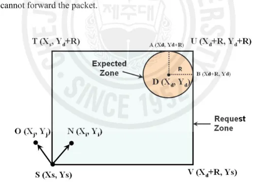
Two LAR protocols have been proposed by authors. One is called LAR scheme 1 and another is known as LAR scheme 2. In LAR scheme 1, in order to search a route from source S to destination D, the protocol defines a smaller forwarding region called request zone that covers both S and D, instead of flooding the request to the entire network. The request zone is made up of the smallest rectangle that contains S’s current location and D’s possible location. In order to forward a packet, a node has to be in the Request Zone otherwise it cannot further forward the packet. In the example shown in Figure 2.2 (similar to a figure in Ko and Vaidya, 2000a), D’s expected location is within the expected zone represented by the shaded circle within a rectangle. The rectangle represents the request zone. In the figure, since node N is located in the request zone, it can rebroadcast the route request packet to other nodes in the zone, but node O which is outside the request zone, cannot forward the packet.
Figure 2.3: In LAR scheme 2, the packet is forwarded only if the distance of current node is shorter than the previous one.
The LAR scheme 2 does not take into account any request zone. Instead, it uses the physical distance from the destination node as a parameter to forward a packet to the next node. The coordinates of the destination are stored in the route request packets. These packets can only travel in the direction of the destination where the relative distance to the destination becomes smaller as they travel from one hop to another. As in Figure 2.3, on receiving a packet from node S, node I will check if its distance from destination DIST(I) is smaller than that of node S i.e., DIST(S). If so, it will forward the packet to its neighboring nodes otherwise it will discard the packet. Both LAR schemes limit the control overhead transmitted through the network and hence conserve bandwidth.
2.2.2 GRID protocol
GRID (Liao et al., 2001) is a fully location-aware reactive routing protocol. In the GRID protocol, the network is partitioned into several square-shaped regions called grids. In each grid, one mobile host, if any, is elected as the grid’s leader and is called gateway. Gateways perform routing grid by grid, while non-gateways are not involved in forwarding packets. This protocol is considered fully location-aware
because it exploits the location information in route discovery, packet relay, and route maintenance phases. The GRID protocol uses location information in the following three ways:
Route Discovery. In the route discovery phase, the route search area is confined by
a forwarding zone. The route search is performed by only the gateway nodes otherwise; the search can send many unnecessary route request packets by non-gateway nodes. Due to this reason, the GRID protocol can be useful in a dense environment.
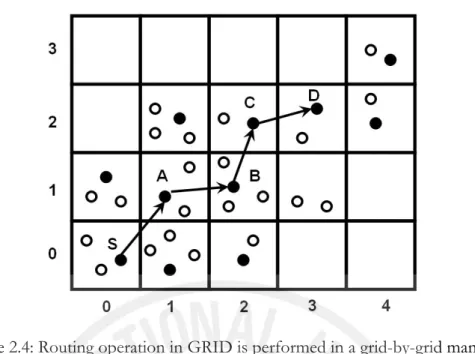
Packet Relay. Since the routing is performed in a grid-by-grid manner, a grid ID
rather than a host ID represents a route. Each entry in a routing table records the next grid that leads to the destination. The packet relay procedure in GRID is shown in Figure 2.4.
Route Maintenance. Route maintenance is used to offer route resilience to host
mobility. When a gateway roams away, the protocol elects another gateway in the grid to take over packet-relaying responsibility. In other reactive routing protocols such as DSR, AODV and LAR, when an intermediate node in a route leaves its neighbors radio range, the route breaks. However, the authors of GRID claim that even if a node roams out of its original grid, the route can still persist since the routing is performed in a grid-by-grid manner.
Figure 2.4: Routing operation in GRID is performed in a grid-by-grid manner. The main advantage of GRID is that it reduces the routing overhead as packet delivery is performed by only the gateway nodes and not by non-gateway nodes. The disadvantage is that in GRID, the grid size is small therefore gateways can move out of grids very frequently as the criteria for gateway election is only the shortest distance from the center of the grid. Hence, nodes inside a grid have to initiate gateway election procedure very frequently causing the network to become unstable. Also, there is no consideration for speed and direction of movement of gateway nodes. In situations where the nodes are moving with very high speeds, this criterion does not seem to be suitable. Secondly, as mentioned in Liao et al. (2001), the side-length of grid should be kept in such a way that several grids can be present under one radio range. Since, the routing is performed in a grid-by-grid manner; the packet has to travel through many extra hops. This situation can be avoided if the packet is allowed to be forwarded to a gateway that lies in the sender’s radio range but may not be present in its adjacent grid. These issues are addressed in chapter 4 in detail.
2.2.3 Greedy Perimeter Stateless Routing (GPSR)
GPSR (Karp and Kung, 2000) is a geographic routing protocol for wireless networks that works in two modes: greedy mode and perimeter mode. In the greedy mode, the packet is forwarded in a greedy manner i.e., each node forwards the packet to the neighbor closest to the destination. In regions where such a greedy path does not exist, GPSR recovers by forwarding the packet in perimeter mode in which a packet traverses successively closer faces of a planar sub graph (face routing) around dead-ends, until the packet reaches a node closer to the destination. At this point, the protocol switches back to the greedy forwarding. In perimeter mode a packet is forwarded using the right-hand rule in a planar sub graph of the network. Since wireless network connectivity in general is non-planar, each node runs the local planarization algorithm such as Gabriel Graph (GG) or Relative Neighborhood Graph (RNG) to create a planar graph. In this case, only a subset of the physical links is used during perimeter routing.
2.2.4 Zone-based Hierarchical Link State (ZHLS)
Zone-based Hierarchical Link State (ZHLS) (Joa-Ng and Lu, 1999) routing protocol is a location-aware routing protocol in which link state routing is performed by all nodes in the network in a peer-to-peer fashion. There is no central authority and every node is responsible for making routing decisions based on link state information sent by other nodes. The network is divided into non-overlapping zones and there are two kinds of topologies; a node level topology and a zone level topology as shown in Figure 2.5 (a) and (b) respectively. Each node constructs an intra-zone routing table for node level packet forwarding and an inter-zone routing table for zone level packet forwarding. The gateway nodes, such as 7 and 11 in Figure 2.5 (a) forward the packets between zones.
Initially, each node knows its own position and therefore, it can easily figure out its zone ID with the help of a GPS receiver. Each node also constructs an intra-zone and an inter-intra-zone routing table. The intra-intra-zone routing table is constructed according to the following steps.
1. Each node broadcasts a link request asynchronously.
2 Nodes within its communication range reply with a link response (node ID, zone ID).
3. After receiving all link responses, the node generates a node LSP (Link State Packet) containing node IDs of its neighbors in the same zone and zone IDs of its neighbors of different zones.
4. The node then floods the Node LSP locally throughout its zone.
5. Each node performs the same procedure; therefore, a list of all the Node LSPs can be stored in every node.
6. Using this list, the node constructs intra-zone routing table using the shortest path algorithm.
After each node receives all Node LSPs from other nodes in its zone, it generates a Zone LSP as well. There is only one Zone LSP for every zone and it tells which other zones are connected to it. The gateway nodes that connect two zones flood the Zone LSPs throughout the network. When all nodes receive Zone LSPs of all zones, they construct inter-zone routing tables again using the shortest path algorithm.
The main advantage of ZHLS is that it reduces the communication overhead of Link State Routing by partitioning the network into zones. The main disadvantage is that every node has to keep the information of whole zone topology. Every node has to keep and update routing tables which is not suitable if there are large numbers of nodes inside a zone. Moreover, although it is a location-aware routing protocol, it does not effectively exploit the location-aware capability.
(a) (b)
Figure 2.5: (a) Node level topology (b) Zone level topology.
2.3 Geocasting Protocols for Ad hoc Networks
In geocasting, a packet is supposed to be sent to all the nodes inside a physical region. Existing geocasting protocols can be classified into two categories.
1. Topology-based Geocasting protocols 2. Face Traversal-based Geocasting protocols
Several protocols are present in the first category but the most famous ones are LBM (Ko and Vaidya, 1998), GeoGRID (Liao et al., 2000) and GAMER (Camp and Liu, 2003). These protocols are mainly based on restricted flooding. Pure flooding is the easiest way to guarantee the delivery of geocast packet to all nodes in a geocast region. Since these geocasting protocols use restricted flooding and packets are forwarded only in a restricted region, these protocols do not guarantee the delivery of geocast packets to all nodes in the geocast region.
In the second category, the protocols use planar graphs and mainly use greedy forwarding in combination with face traversals. Protocols present in this category are more likely to guarantee the delivery of geocast packets to all nodes in a geocast
region. The details about some of the geocasting protocols are discussed in the following subsections.
2.3.1 Topology-based Geocasting protocols.
The protocols falling in this category are discussed as follows:
2.3.1.1 Location-Based Multicast (LBM)
Location Based Multicast (LBM) (Ko and Vaidya, 1998) is a geocasting protocol based on flooding but avoids flooding the whole network by defining a forwarding zone. Outside the forwarding zone the packet is discarded. Two schemes are proposed for LBM that improve multicast flooding with position information. Both the schemes are derived from Location Aided Routing (LAR) (Ko and Vaidya, 2000a), which is a location based protocol for unicast routing in ad hoc networks.
In LBM scheme 1, a forwarding zone is defined to avoid simple flooding that includes at least the destination geocast region and a path between the sender and the geocast region. An intermediate node forwards the packet only if it lies inside the forwarding zone. Authors have defined a parameter δ for increasing the size of the forwarding zone. By increasing the value of δ, the forwarding zone increases and hence the probability of delivering a geocast packet to all destination nodes can be increased. However, the overhead is also increased. In the simulations, the value of δ is increased from 0 to 150. Results show that if the value of δ is increased to 150, the protocol behaves similar to flooding which increases the overhead to a large extent. Similar to the unicast routing protocol LAR, the forwarding zone can be the smallest rectangular region that includes the sender and the destination region. The co-ordinates of the forwarding zone are included in each geocast packet so that each node can determine whether it belongs to the forwarding zone.
The second scheme of LBM defines the forwarding zone by the location coordinates of the sender, the geocast region, and the distance of a node from the center of the geocast region. A node that receives a geocast packet determines
whether it belongs to the forwarding zone by calculating its own distance from the center of the geocast region. If its distance is smaller than the distance of its one-hop predecessor, the geocast packet is forwarded to all neighbors and the packet sender’s distance is replaced by its own distance. Finally, the packet is flooded to all neighbors if the predecessor node is located inside the geocast region.
2.3.1.2 GeoGRID
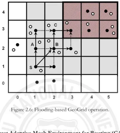
GeoGRID (Liao et al., 2000) is based on its predecessor unicast routing protocol called GRID. GeoGRID partitions the network into logical grids, with a single elected gateway in each partition. One host close to the grid center is elected as gateway which is responsible for propagating geocast packets to neighboring grids. Only gateways forward packets, which relieves other nodes from inefficient flooding. Similar to GRID protocol, geocast packets are sent in a grid-by-grid manner through their gateways. This decreases message overhead by excluding non-gateways from packet flooding. Prior to sending a geocast packet, no routes are established. A rectangular forwarding region is used for forwarding a geocast packet in order to have restricted flooding. Packets are forwarded by only those nodes that are present in the forwarding region. Outside the forwarding region a received packet is discarded.
Another geocasting protocol called ticket-based GeoGRID is also proposed. In the second scheme a gateway within the forwarding region forwards geocast packets, but only a limited number of gateways do this job. To limit the number of gateways, a gateway forwarding a packet sends it to at most three neighbors rather than to every neighbor. The idea is that each ticket is responsible for carrying one copy of the geocast packet to the destination region. Thus, by selecting a certain number of tickets the initial sender not only determines the overhead of geocast delivery but also the success probability of delivery.
Figure 2.6: Flooding-based GeoGrid operation.
2.3.1.3 Geocast Adaptive Mesh Environment for Routing (GAMER)
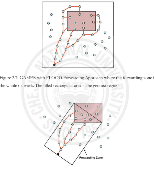
The authors of Geocast Adaptive Mesh Environment for Routing (GAMER) (Camp and Liu, 2003) protocol propose a mesh-based geocasting protocol that provides redundant paths between the source and the geocast region. A node that wants to send packets to a geocast region first floods a JOIN-DEMAND (JD) packet in a forwarding zone until it reaches a node in the geocast region. After receiving the packet, this node unicasts a JOIN-TABLE (JT) packet back to the source node following the reverse route taken by the JOIN-DEMAND packet. When the source node receives its first JOIN-TABLE packet, it can start sending geocast packets via the path created to the geocast region. Since more than one node can send back the JOIN-TABLE packet, a mesh will be created which is used for sending packets on multiple redundant links.
GAMER defines three candidate Forwarding Approaches (FAs) for sending the JOIN-DEMAND packet. In each FA, the JD packet is flooded in their respective forwarding zones. These Forwarding Approaches are, CONE, CORRIDOR and FLOOD FAs that a source can choose based on the network condition. Therefore,
when nodes are highly mobile, a dense mesh is created and when nodes are moving slowly, a sparse mesh is created. These three Forwarding Approaches are illustrated in Figures 2.7, 2.8 and 2.9 (The figures are similar to those in Camp and Liu, 2003).
Figure 2.7: GAMER with FLOOD Forwarding Approach where the forwarding zone is the whole network. The filled rectangular area is the geocast region.
Figure 2.8: GAMER with CORRIDOR Forwarding Approach.
Two versions of GAMER are proposed by the authors: passive GAMER and active GAMER. In passive GAMER, the JOIN-DEMAND packets are transmitted at a fixed frequency at every JOIN-DEMAND packet interval regardless of whether a
JOIN-TABLE packet is received. Whereas, in active GAMER, the JOIN-DEMAND packets can be sent at a higher rate if a JOIN-TABLE packet is not returned within a given timeout period.
Figure 2.9: GAMER with CONE Forwarding Approach.
2.3.2 Face Traversal based Geocasting protocols
The face traversal based geocasting protocols use the planar graphs for routing the packets to the geocast region. Some of these protocols are discussed as follows:
2.3.2.1 Geographic Forwarding Perimeter Geocast (GFPG)
In Seada and Helmy (2004), authors proposed a Geographic Forwarding Perimeter Geocast (GPFG) algorithm that attempts to guarantee the delivery of geocast packets to all nodes in a geocast region. Authors observed that it is sufficient to traverse only those faces that intersect the boundary of a given geocasting region to ensure delivery of packets to nodes in a geocast region. The source node first sends the packet towards the geocast region using the GFG algorithm (Bose et al. 2001). After reaching the geocast region, each node inside the region retransmits the packet when receiving it for the first time. This is termed as regional flooding.
A node is considered as a border node if it has neighbors connected outside of the geocast region. The faces intersecting the region are traversed by sending perimeter packets to the neighbors outside the region in the planar graph. After
receiving the perimeter mode packet, the node outside the region forwards it to its neighbor using the right-hand rule. The packet traverses the face until it enters the region again. The first node inside the region floods it inside the region if it receives for the first time, otherwise ignores it (Seada and Helmy, 2004).
Although, the authors of Seada and Helmy (2004) claim that their protocol guarantees the delivery of geocast packets, Stojmenovic (2004) shows that GFPG does not guarantee delivery. The author improved the algorithm presented in Seada and Helmy (2004) and proposes an enhanced geocasting algorithm that shows the delivery guarantee. The authors of Lian et al. (2006) name this improved protocol as Restricted Flooding with Intersected Face Traversal (RFIFT).
2.3.2.2 Restricted Flooding with Intersected Face Traversal (RFIFT)
The main difference between GFPG and RFIFT is that, in RFIFT external border nodes perform right hand rule based face traversals with respect to all corresponding neighboring internal border nodes no matter how the message arrives to them. Whereas, in GPFG, it is activated only from internal border neighbor, for one face at a time as described in Seada and Helmy (2004).
In RFIFT, by sending perimeter packets to neighbor nodes outside the geocast region, the faces intersecting the region are traversed. The node outside the region receiving the perimeter mode packet forwards the packet using the right-hand rule to its neighbor and so on (Stojmenovic, 2004). Here, every face intersecting the geocasting region and connected to the source is fully traversed by the combination of regional flooding and outer face traversals. The main point here is that the right-hand traversal of any face is composed of pieces containing regional flooding for consecutive face nodes inside a region, and pieces outside the region that are triggered when a packet is received there. The author says that, regional flooding, piecewise face traversal, and connectivity ensure that all possible nodes are reached hence guaranteeing the delivery of packets to all nodes (Stojmenovic, 2004). The author also shows that the scheme is close to a message optical scheme, since each
node in the region transmits the packet only once. The details of the algorithm can be found in Stojmenovic (2004).
Although the author of RFIFT shows with proofs that their proposed protocol guarantees the delivery of packets to all nodes, there are no simulations shown for this purpose. Moreover, the face traversal based algorithms using planar graphs are usually very slow in terms of computation time as they spend a lot of time in traversing faces of a planar graph. The high maintenance costs and complexities associated with the deployment of face routing algorithms make them quite expensive.
Chapter 3
LOCATION-AWARE GRID-BASED
HIERARCHICAL ROUTING IN MOBILE
AD HOC NETWORKS
In this chapter, a hierarchical routing protocol called Location-aware Grid-based Hierarchical Routing (LGHR) is proposed for mobile ad hoc networks, which uses non-overlapping zones for efficient routing. The whole network is divided into non-overlapping zones and each zone is then further divided into smaller grids.Each node knows its position with the help of a GPS receiver. The protocol is a location-aware routing protocol but the routing is performed in a similar way as in link state routing. That is, the neighbor node information is needed for creating routing tables and making routing decisions. Each zone has a leader node and all nodes in a zone send their neighbor node information to the leader. The leader is responsible for maintaining routing tables and making routing decisions. Each smaller grid in a zone has a gateway node which is responsible for its own grid. The leader sends the routing tables to respective gateway nodes present in its zone. On the basis of these routing tables, the gateway nodes forward the packets. The protocol is compared with another location-aware hybrid zone-based routing protocol called Zone-based Hierarchical Link State (ZHLS) (Joa-Ng and Lu, 1999). ZHLS, which is also a hierarchical routing protocol, uses link state routing in each zone. Each node in a zone sends its link state packets to all other nodes in its zone. Therefore, each node stores and makes intra-zone and inter-zone routing tables causing huge communication overhead in case there are large numbers of nodes in a zone. The proposed protocol LGHR reduces the communication and storage overhead by further partitioning each zone into smaller grids. Unlike ZHLS, only the gateway
nodes keep the routing tables and routing is performed in a gateway-by-gateway manner. Non-gateway nodes are not responsible for keeping these tables and forwarding the incoming packets.
In ZHLS protocol, despite the fact that each node has a GPS receiver; it does not effectively utilize the location-based capability like other position-based routing protocols. The protocol initiates a reactive zone search mechanism if the destination node lies outside the current source’s zone. The proposed protocol uses pro-active mechanism inside a zone but unlike ZHLS, it does not initiate a reactive zone search mechanism if the destination lies outside the zone of the source node. Instead, the location-based strategy is used to identify the destination’s zone by mapping the position of destination on the zone map. The analysis of both protocols is shown in chapter 4.
The proposed protocol is also compared with another location-aware routing protocol called GRID (Liao et al., 2001) in order to check the stability of the protocols. The stability factor is chosen on the basis of gateway election mechanisms. The evaluation of both protocols is done in chapter 4. The simulation results show that the proposed protocol LGHR is more stable than GRID especially in scenarios where the wireless nodes are moving with very high velocities.
3.1 Introduction
A mobile ad hoc network is composed of a number of wireless nodes connected through radio links forming a dynamic autonomous network in a mobile manner. Nodes communicate with one another without any centralized access points and each node acts both as a router as well as a host. Several routing protocols have been proposed by various researchers for mobile ad hoc networks (Basagni et al., 1998; Joa-Ng and Lu, 1999; Haas and Pearlman, 1998; Jacquet et al., 2003; Johnson and Maltz, 1996; Karp and Kung, 2000; Ko and Vaidya, 2000a; Park and Corson, 1999; Perkins et al., 2003) which include proactive, reactive and hybrid routing. Zone Routing Protocol (ZRP) (Haas and Pearlman, 1998) is a hybrid routing
protocol in which proactive mechanism is performed for the intra-zone routing whereas reactive strategy is initiated during the inter-zone routing. Zone-based Hierarchical Link State (ZHLS) (Joa-Ng and Lu, 1999) is another hybrid routing protocol in which there is no central zone-head or leader and all nodes communicate in a peer-to-peer fashion. Proactive link state routing is done inside the zone and a reactive zone search mechanism is initiated when the destination node lies in a different zone than that of the source node. The problem with this protocol is that every node has to keep the information of the whole zone topology which is not suitable if there are large numbers of nodes inside the zone. Since there is no central authority, every node has to keep and update routing tables even if they are not involved in forwarding packets to other nodes. Moreover, although ZHLS is a GPS-based protocol, it does not fully utilize the position information taken by the GPS receiver. For example, if a node wants to send a packet to a node and the destination node lies in the same zone, it uses its intra-zone routing table which is made on the basis of the local link state information. And if the destination node does not lie in the same zone, then it initiates a reactive zone search mechanism in order to get the zone ID of the destination. The protocol can save a lot of messages if it exploits the location information received by the GPS receiver. It only uses this information to let a node know which zone it lies in. Like other location based protocols, if it knows the location of the destination, it can easily identify the zone ID of the destination. The location of the destination can be found by using a location server, as used in other location-aware routing protocols like LAR, GPSR and GRID etc.
In GRID (Liao et al., 2001), which is a location-aware reactive routing protocol, authors use the term “grid” instead of a zone and propose a grid-based routing mechanism in which every grid has a gateway node and routing is performed only through gateways in a grid-by-grid manner. The gateway node is elected by a gateway election procedure. Like all reactive routing protocols, this protocol also has to search a route if a node wants to send a packet to another node. Hence, there is a route request and route reply mechanism. One major problem with this protocol is that, since the grid size is small, the gateway nodes are likely to move out of the grid very frequently as the criteria for gateway election is only the shortest distance