논습지의 생태계서비스 가치평가를 위한 기능 및 요인분석
˳
The Analysis of Function and Factors for the Value Assessment of Ecosystem Service at Rice Paddy Wetland
Kong, Min-Jae* · Lee, Byung-Mo** · Kim, Nam-Choon*** · Son, Jin-Kwan**+
* Relationship of Dankook University & Rural Development Administration.
** National Academy of Agricultural Science, RDA
*** Dept. of Landscape Architecture, Dankook Univ.,
요 약
최근들어 세계환경의 화두는 습지와 더불어 논습지 그리고 습지의 생태계서비스 기능에 집중 조명되고 있지만 논, 습지의 생태계서비스를 평가 할 수 있는 연구체계가 부족한 실정이다 따라서 본 연구는 기존의 습지평가체계를. 논습지에 적용하여 습지로서 논의 가치를 평가해보는 동시에 논습지 중심의 평가체계를 구축하는 기초자료로 활 용하고자 연구를 진행하였다 연구 대상지는 고도와 토양을 기준으로. 16곳을 선정하였다. 습지평가 결과 연구대 상지16곳은 총점110 ~118 ,점 점 평균2.17~2.50으로 선행연구 사례지인 호수형습지 소택형습지 하천형습지와 비교, , 해도 습지로서 가치가 인정되었다고 할 수 있다 하지만 고도 토성에 따라서는 평가결과의 차이는 없었으며 보전. , , 가치는 모두 같게 나타났다. Pearson 상관분석을 통해 보전가치에 가장 밀접하게 작용하는 요인을 찾아 본 결과, 면적이 상관관계가 있는 것으로 나타났다 그러나 기존의 습지평가체계로 논습지에 적용하기에는 한계가 있는 것. 으로 사료되어 논습지 평가를 위해서는 재배유형 지형적 특성 식생특성 생육환경 생물다양성 등의 다양한 후속, , , , 연구를 통해 습지평가체계를 보완할 필요가 있는 것으로 판단하였다.
핵심용어: 농업경관 생물다양성, , RAM, 보전 복원,
Abstract
Recently, wetland and paddy wetland are being highlighted as the international environmental issues. However, research system which can assess paddy wetland is lacking. Thus, the purpose of this study is to assess the value of paddy wetland by applying RAM to paddy wetland. In addition, we would like to use this study as the data to establish assessment method for paddy wetland. 16 sites were selected as research targets based on altitude and soil.
As the results of wetland assessment, 16 research target sites had total score of 212~227 and the average of 2.17~2.50. It was similar to those of Lacustrine Wetlands, Palustrine Wetland and Riverine Wetland which were sites in previous studies. The value could be recognized as the wetland. However, there was no difference in assessment results based on altitude and soil. It was found that all conservation values were the same. The factor the most closely affecting conservation value was the area. However, there was limitation to apply existing wetland assessment system to paddy wetland. In order to assess paddy wetland, factors such as rice farming methods, topography, vegetation, growth environment and biodiversity should be added. It was thought to supplement wetland assessment system through various further studies.
Keyword : Agricultural Landscape, Bio-diversity, RAM, Conservation, Restoration
+ Corresponding author : [email protected], +82-31-290-1817
환경오염에 의한 종 다양성의 감소는 우리나라뿐 아니라 세계적으로 중요한 문제로 대두 되고 있으 며 국제사회는 생물다양성의 중요성을 인식하고,
년 유엔환경회의 에서 생물다양성협약
1992 (UNCED)
을 채택한 이래 년을 세계생물다양성의
(CBD) 2010 “
해(International Year of Biodiversity)”로 정하여 생물 다양성 보전을 위한 노력을 기울이고 있다(Ok, 생물다양성이라 함은 우 2004; Koo and Lee, 2012).
리가 흔히 얼마나 다양한 종이 있는가를 말할 때 사용하는 종 다양성과는 다른 의미로서 종 자체의 다양성 뿐만 아니라 생태계 혹은 유전자원의 다양 성과 그들 사이의 변이성까지도 포함하는 매우 포 괄적인 개념이다(Seo, 1999).
습지는 열대지역에서 한대지역까지 고루 분포하 며, 지구 표면의 4 6%〜 정도에 해당하고 있다 또한 습지는 생물다양 (Mitsch and Gosselink, 2000).
성의 보고로서 동 식물 미생물 등의 서식지이며 오․ , , 염물질의 정화 홍수조절 기후 완화 여가 심미적, , , , 기능 등 환경적으로나 사회 문화경제적으로 그 가․ ․ 치가 매우 높은 곳이다(Korea Environment Institute 따라서 습지가 가지고 있는 다양한 (KEI), 2006).
생태 환경학적 중요성에 대한 인식이 확대되고 있ㆍ 으며 하천이나 호소의 수질을 개선하기 위한 대안, 으로 습지의 보전이나 복원 및 효율적인 이용 방안 에 대한 관심이 높아지고 있다(Lee et al., 2010).
습지란 자연적인 것도 인공적인 것도 포함하며“ , 또한 영속적인 것이나 일시적인 것이나 물이 체류, 하고 있거나 흐르고 있거나 혹은 담수이건 기수이, 건 염수이건 간에 습원이나 소택지 이탄지 혹은, , 하천이나 호소 등의 수역으로 수심이 간조시에, 6m 를 넘지 않는 해역을 포함한다 라고.” Ramsar조약 1 조에 정의되어 있다. Ramsar 조약에서 정의된 습지 혹은 습지를 포함하는 생태계는 크게는 하천의 집 수 지역 전체 또한 그 집수지역에 포함되는 범람원, 이나 하구 호소 습원이라는 경관 단위로 분류되는, , 것이 일반적이다(Korean Environmental Preservation Association (KEPA), 1996).
최근 세계적으로 환경오염 및 생물다양성의 보전 및 증진을 위해 습지를 활용한 효율적인 이용방안
회에서 습지 시스템으로서 논의 생물다양성 증진‘ 결의문(Enhancing biodiversity in rice paddies 이 채택되면서 논을 활용한 생물 aswetland systems)’
다양성 증진에 대한 관심이 높아지고 있다(Ramsar, 2008).
또한, 습지는 생산(production), 제어(regulation), 서식지(habitat), 정보(informational) 등 4가지 분류 속에 홍수조절 지하수보충 제방안정화 영양물질, , , 침전 및 이동 수질 정화 생물다양성 제품생산 문, , , , 화보전 레크레이션 기후완화 등 다양한 생태계서, , 비스 기능을 제공하는 것으로 알려져 있다(Maltby, 2009; Ramsar, 2014).
따라서 본 연구는 최근 람사르 총회에서 생물다 양성 증진효과가 인정된 논습지를 대상으로 논습지 의 기능을 유형에 따라 평가하고 기존의 습지평가 체계와 비교를 통해 논습지 평가에 작용할 수 있는 인자를 찾으려 한다 이러한 연구를 통해 논습지의. 가치에 영향을 미치는 인자를 찾아보는 한편 논습, 지의 가치평가 체계 구축의 기초자료로 활용되길 기대한다.
조사 및 분석방법 2.
연구대상지 2.1
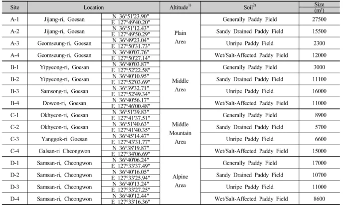
연구 대상지는 충정북도 괴산군 청주시로 우리, 나라의 경우 표고를 기준으로 하는 벼 재배적지를 개 지대로 구분한 평야지 중간지 중산간지 산간고
4 ‘ / / /
냉지 의 기준과‘ (Kim, 2005), 우리나라의 논유형 가5 지(Rural Development Administration(RDA), 1992)중 특이산성논 을 제외한 현재 우리나라에 가장 많이
’ ‘
분포하는 보통논 사질논 미숙논 습답 및 염해논 으’ / / / ‘ 로 한정하여 접근성을 고려해 총 16곳을 선정하였 다(Table 1).
대상지의 수문학적 특성은 우리나라 논의 전형적 인 특성인 계절적 침수 형태이며 일부대상지에서는, 소택지가 위치하고 있어 수문학적으로 연중 연결되 는 체계를 가지고 있다 또한 모든 대상지 근처에는. 논 수로 계곡 하천이 위치하고 있어 수원 확보가, , , 용이한 것으로 판단된다.
Kong, Min-JaeㆍLee, Byung-MoㆍKim, Nam-ChoonㆍSon, Jin-Kwan
Site Location Altitude1) Soil2) Size
(m²) A-1 Jijang-ri, Goesan N 36°51'23.90"
Plain Area
Generally Paddy Field 27500 E 127°49'40.20"
A-2 Jijang-ri, Goesan E 127°49'50.29"N 36°51'12.43" Sandy Drained Paddy Field 15500 A-3 Geomseung-ri, Goesan E 127°50'31.73"N 36°49'23.04" Unripe Paddy Field 2300 A-4 Geomseung-ri, Goesan E 127°50'27.14"N 36°40'07.76" Wet/Salt-Affected Paddy Field 12000 B-1 Yipyeong-ri, Goesan N 36°40'03.87"
Middle Area
Generally Paddy Field 3000 E 127°52'22.58"
B-2 Yipyeong-ri, Goesan E 127°52'03.69"N 36°40'10.95" Sandy Drained Paddy Field 11100 B-3 Samsong-ri, Goesan E 127°52'49.34"N 36°39'32.71" Unripe Paddy Field 16000 B-4 Dowon-ri, Goesan E 127°46'00.48"N 36°40'56.17" Wet/Salt-Affected Paddy Field 11000 C-1 Okhyeon-ri, Goesan N 36°51'39.83"
Middle Mountain
Area
Generally Paddy Field 8900 E 127°41'37.51"
C-2 Okhyeon-ri, Goesan E 127°41'40.35"N 36°51'40.63" Sandy Drained Paddy Field 5700 C-3 Yanggok-ri Goesan E 127°43'31.77"N 36°45'14.47" Unripe Paddy Field 6600 C-4 Galsan-ri Cheongwon E 127°34'06.69"N 36°38'19.87" Wet/Salt-Affected Paddy Field 15000 D-1 Samsan-ri, Cheongwon N 36°40'06.24"
Alpine Area
Generally Paddy Field 17000 E 127°33'37.49"
D-2 Samsan-ri, Cheongwon E 127°33'25.94"N 36°40'16.05" Sandy Drained Paddy Field 10700 D-3 Samsan-ri, Cheongwon E 127°33'27.25"N 36°40'13.24" Unripe Paddy Field 11000 D-4 Samsan-ri, Cheongwon E 127°33'16.36"N 36°40'12.44" Wet/Salt-Affected Paddy Field 8600 Table 1. The characteristics of study sites.
* 1) Kim(2005), 2) RDA(1992).
연구대상지 습지 기능평가 2.2
본 연구에서 사용한 습지평가 체계는 Tilton et
의 을 활용 하
al.(2001) RAM(Rapid Assessment Method)
였으며 평가의 구성은 습지의 기능을 가지로 나누, 8
어 기능별로 4~8개의 평가요소를 통해 높음(High, 2.4 이상), 보통(Moderate, 1.7 2.3),∼ 낮음(Low, 1.7 이하 의) 세 가지 등급으로 평가하였다.(Table 2).
Evaluation topics Evaluation elements Evaluation topics Evaluation elements
1. Floral Diversity and Wildlife Habitat
1. Distance to Other Wetlands, 2. Number of Different Types of Vegetative
Communities Present, 3. Degree of Community Interspersion,
4. Wetland Size, 5. Surrounding Land Use,
6. Wildlife Corridor
5. Water Quality Protection
1. Ability of immediate watershed to deliver runoff, 2. Inlet type,
3. Outlet, 4. Percentage of open water,
5. Maximum water depth, 6. Hydroperiod, 7. Channel or sheet flow,
8. Wetland size,
9. Wetland to immediate watershed ratio
2. Fishery and Herpetile Habitat
1. Relationship to permanent water body, 2. Percentage of open water, 3. Degree of interspersion of open water and cover,
4. Hydroperiod, 5. Vegetation type
6. Shoreline /Stream Bank Protection
1. Channel or sheet flow, 2. Vegetation type, 3. Vegetation width, 4. Evidence of active erosion,
5. Land use
3. Flood/Storm Water Storage
1. Ability of immediate watershed to deliver runoff, 2. Relation to surface water connection,
3. Inlet type, 4. Outlet, 5. Wetland size,
6. Wetland to immediate watershed ratio
7. Aesthetics and Recreation
1. Vegetation classes present, 2. Interspersion of Vegetation,
3. Wetland size, 4. Surround land use,
5. Accessibility, 6. Visibility, 7. Presence of debris, 8. Presence of wildlife habitat,
9. Presence of fishery habitat
4. Runoff Attenuation
1. Ability of immediate watershed to deliver runoff, 2. Inlet type,
3. Outlet,
4. Interspersion of land and water, 5. Hydroperiod, 6. Channel or sheet flow,
7. Vegetative type, 8. Wetland size
8. Groundwater Recharge
1. Soil characteristics, 2. Ratio of wetland to immediate watershed, 3. Ability of immediate watershed to deliver runoff,
4. Outlet
Table 2. The evaluation topics of Tilton et al.(2001)'s RAM
본 연구 대상지의 보전가치 판단은 RAM의 지표에 따라 산정된 높음 보통 낮음의 값에 의해 결정된다, , .
4 , , ,
혹은 향상으로 보전 복원전략이 수립된다, (Table 3).
Preservation priority Criteria Conservation,
Restoration strategy First, Consider
conservation
International or domestic protection value if found in the
protected Species of Korea or habitat A typical, rare case of high conservation value
Absolute Conservation
High
Individual function evaluation value is "high" as table
the total function of 1/2 or more If the total value of the average is 2.4 or higher
Evaluation elements of "High" to the table element is
overall assessment elements 1/2 or more
Conservation
Moderate
Individual function evaluation value "high" feature one or more,
full function of 1/2 is less than
If the total value of the average is 1.7, less than 2.4
Evaluation elements of "High" to the whole element of
the element table 1/2 is less than Evaluation elements of "high", but the elements of a
"Middle" all the elements of more than 1/2
Improvement
Low In the case of all other cases Restoration or
Improvement Table 3. Conservation Value Criteria
결과 및 고찰 3.
연구대상지 습지기능 평가 3.1
본 연구에서 사용한 습지평가 체계의 구성은 습지
의 기능을 가지로 나누어 기능별로8 4~8개의 평가요 소 총52항목을 통해 높음 보통 낮음의 세 가지 등, , 급으로 평가한다 연구대상지 별 구체적인 기능평과. 결과는 다음과 같다(Figure 1).
1. Floral Diversity and Wildlife Habitat 2. Fishery and Herpetile Habitat
3. Flood/Storm Water Storage 4. Runoff Attenuation
Kong, Min-JaeㆍLee, Byung-MoㆍKim, Nam-ChoonㆍSon, Jin-Kwan
5. Water Quality Protection 6. Shoreline/Stream Bank Protection
7. Aesthetics and Recreation 8. Groundwater Recharge
Figure 1. The graph of evaluation results for 8 functions.
Evaluation topics
Sites
Average
A-1 A-2 A-3 A-4 B-1 B-2 B-3 B-4 C-1 C-2 C-3 C-4 D-1 D-2 D-3 D-4
1 15 15 14 14 13 15 15 15 14 14 14 15 15 15 15 14 2.42
2 10 10 11 11 11 11 11 10 10 10 11 11 11 11 10 11 2.13
3 14 14 13 14 13 14 14 14 14 14 14 14 14 14 14 14 2.31
4 16 16 16 17 16 17 17 16 16 16 17 17 17 17 16 17 2.06
5 21 21 20 21 20 21 21 21 21 21 21 21 21 21 21 21 2.32
6 7 7 10 9 10 10 8 7 10 9 10 8 10 10 9 10 1.80
7 21 21 22 21 19 21 21 20 19 19 20 21 20 19 19 18 2.23
8 8 9 8 8 8 9 8 8 10 10 10 10 10 11 10 10 2.30
Total Score 112 113 114 115 110 118 115 111 114 113 117 117 118 118 114 115 -
Table 4. The evaluation results and total score of the 8 function
* 1 : Floral Diversity and Wildlife Habitat, 2 : Fishery and Herpetile Habitat, 3 : Flood/Storm Water Storage, 4 : Runoff Attenuation, 5 : Water Quality Protection, 6 : Shoreline/Stream Bank Protection, 7 : Aesthetics and Recreation, 8 : Groundwater Recharge.
기능평가 결과 연구대상지 16곳은 총점 110 ~118점 점 사이의 분포로 나타났으며(Table 4), 연구대상지
에서 가장 낮게 에서 가능 높게 평
B-1 B-2, D-1, D-2 가된 것을 확인 할 수 있다.
가지 기능별로 살펴보면 평가결과 논습지
8 RAM
개 대상지 평균이 로 가장 높게 평가된 식생다
16 2.42
양성 및 야생동물서식처(Floral Diversity and Wildlife
의 제공 능력이 가장 높음을 알 수 있다 이것
Habitat) .
은 개의 평가 항목 중 식물군집의 혼재도6 (Degree of 를 제외한 다른습지 까지의 Community Interspersion)
거리( Distance to Other Wetlands), 식물군집 수 (Number of Different Types of Vegetative Communities
주변토지이용 야생동
Present), (Surrounding Land Use), 물 이동통로(Wildlife Corridor) 등의 기능이 농촌 농,
/Stream Bank Protection) 기능이 1.80, 침식조절(Runoff 기능이 으로 가장 낮음을 확인 할 Attenuation) 2.06
수 있었다 이것은 평가항목 대부분이 보통. (moderate,
이나 낮음 으로 평가되어 나타난 현상으로
2) (Low, 1)
보여진다 일반적으로 알려진 논의 공익적 기능으로. 는 홍수조절 수질개선 지하수 보충 대기정화 등으, , , 로 알려져 있으며 본 평가체계의 결과에서는 홍수저, 장 및 조절(Flood/Storm Water Storage), 수질보호 및 개선(Water Quality Protection), 지하수 유지 및 보충 기능은 보통의 등급으로 비슷 (Groundwater Recharge)
하게 평가되었다.
연구대상지 보전가치 판단 3.2
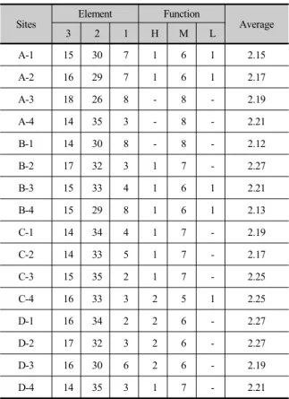
본 연구 대상지의 보전가치 판단기준은 절대보전, 보전 향상 복원 혹은 향상의 가지 등급으로 구분하, , 4 여 보전 복원전략을 수립하는데, Koo(2009)의 가치판 단 기준에 따라 평가하였다.
Sites Element Function
Average
3 2 1 H M L
A-1 15 30 7 1 6 1 2.15
A-2 16 29 7 1 6 1 2.17
A-3 18 26 8 - 8 - 2.19
A-4 14 35 3 - 8 - 2.21
B-1 14 30 8 - 8 - 2.12
B-2 17 32 3 1 7 - 2.27
B-3 15 33 4 1 6 1 2.21
B-4 15 29 8 1 6 1 2.13
C-1 14 34 4 1 7 - 2.19
C-2 14 33 5 1 7 - 2.17
C-3 15 35 2 1 7 - 2.25
C-4 16 33 3 2 5 1 2.25
D-1 16 34 2 2 6 - 2.27
D-2 17 32 3 2 6 - 2.27
D-3 16 30 6 2 6 - 2.19
D-4 14 35 3 1 7 - 2.21
Table 5. The analysis of factor, function and average value.
습지의 보전가치 판단은 기능평가 가치평균 평가, , 요소의 결과에 의해 판단된다 개별 평가등급이 높음. 으로 평가된 연구대상지는 개 사이로 나타
(High) 14~18
Figure 2. The evaluation results and conservation value at 16 study sites.
전체 요소의 가치 평균으로 판단하면 모든 연구대 상지에서 향상 등급으로 판단이 가능하다(Figure 2.).
Kong, Min-JaeㆍLee, Byung-MoㆍKim, Nam-ChoonㆍSon, Jin-Kwan
또한 평가요소 중 높음 으로 나타난 기능이 전체의“ ” 이상인 경우를 살펴보면 높음의 등급으로 평가된 1/2
연구대상지는 14~18개 사이로 나타나 보전 등급의 연 구대상지는 없는 것으로 나타났다
평가항목 분석 및 제안 3.3
습지의 보전가치 판단에 가장 밀접하게 작용하는 평가항목 및 기능을 알아보기 위하여 상관분석과 회 귀분석을 실시하고 Table 6.에 제시하였다 평가요인. 은 면적 고도 습지의 규모 및 기능평가의 평균 등을, , 기준으로 하여 평가항목과 어떠한 관련이 있는지 알 아보았다.
분석결과 개의 평가 기능 중 식생다양성 및 야생8 동물 서식처(Floral Diversity and Wildlife Habitat), 침 식 조절( Runoff Attenuation), 수질보호 및 개선(Water
미적레크레이션
Quality Protection), ․ (Aesthetics and 기능의 결과 값은 평과결과 및 보전 Recreation)
가치에 영향을 미치지 않는 것으로 분석되었다 이것. 은 논의 경우 위의 가지 기능에는 크게 영향을 받지4 않는 것으로 판단 할 수 있으며, RAM의 평가체계를 수정 할 필요가 있다고 판단된다 반면 논습지의 보. 전가치 판단에 밀접하게 작용하는 기능으로는 어류 및 양서파충류 서식처(Fishery and Herpetile Habitat), 홍수저장 및 조절(Flood/Storm Water Storage), 호안 및 제방보호(Shoreline /Stream Bank Protection), 지하 수 유지 및 보충(Groundwater Recharge) 기능으로 분 석되었다 또한. 52개 평가항목 중 보전가치 판단에 밀접하게 작용하는 항목으로는 개방수면과 식생피복 과의 혼재도(Degree of interspersion of open water and
육역과 수역의 혼재도
cove), (Interspersion of land and
식생대 폭 영구적인 수체와
water), (Vegetation width),
의 관련성(Ability of immediate watershed to deliver 등으로 분석되었다
runoff) .
Factors Total score Total Average
Correlation Regression Correlation Regression
Altitude .462
.072
y =0.0135x + 111.47 R² = 0.2254
.662**
.005
y =0.0005x + 2.0854 R² = 0.4632
E l e m e n t
Degree of interspersion of open water and cover
.573*
.020
y =2.8667x + 109.97 R² = 0.3287
.536*
.032
y =0.0650x + 2.090 R² = 0.2840 Interspersion
of land and water
.573*
.020
y =2.8667x + 109.97 R² = 0.3287
.536*
.032
y =0.0650x + 2.090 R² = 0.2840
Vegetation width .573*
.020
y =2.8667x + 109.97 R² = 0.3287
.536*
.032
y =0.0650x + 2.090 R² = 0.2840 Ability of immediate watershed to deliver
runoff
.465 .070
y =1.1250x + 112.38 R² = 0.2160
.655**
.006
y =0.6827x + 0.7859 R² = 0.5647
F u n c t i o n
Average of Fishery and Herpetile Habitat .573*
.020
y =14.333x + 84.167 R² = 0.3287
.536*
.032
y =0.0650x + 2.090 R² = 0.2840
Average of Runoff Attenuation .826**
.000
y =30.769x + 51.087 R² = 0.6827
.753**
.001
y =0.6827x + 0.7859 R² = 0.5647 Average of Shoreline/Stream Bank
Protection
.440 .088
y =4.5455x + 106.44 R² = 0.1939
.607*
.013
y =0.1545x + 1.9174 R² = 0.3767
Average of Groundwater Recharge. .589*
.016
y =5.6274x + 101.70 R² = 0.3470
.763**
.001
y =0.1784x + 1.7859 R² = 0.5861 Table 6. The correlation and regression analysis between the evaluation result.
* Correlation is significant at the 0.05 level, ** Correlation is significant at the 0.01 level: :
한편 식생다양성 및 야생동물 서식처의 기능의 결, 과는 면적(Wetland Siz)에 가장 밀접하게 작용하며, 호안 및 제방보호 기능은 침식의 흔적(Evidence of
고도 와 상관관계가 인정되는
active erosion), (Altitude)
것으로 확인되었다 미적 레크레이션 기능은 주변토지. 이용(Surround land use)의 평가결과로 좌우되는 것으 로 분석되었다.
상관분석결과 논의 면적은 각 평가항목의 평균 간 에 상관관계가 있는 것으로 나타났으나 앞에서 거론, 한 것과 같이 RAM의 평가체계로 논에 적용하기에는 아직 미흡하다고 판단되며 논습지의 대표기능이 한가 지 평가항목에 의해 결정되는 현상을 나타내고 있다.
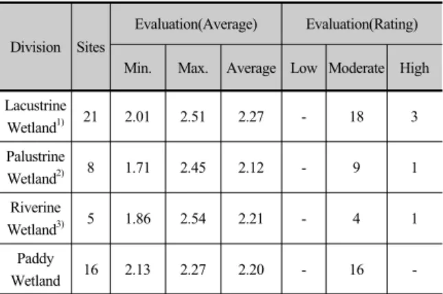
선행연구에서 RAM을 통해 실시한 습지유형별 기 능평가 결과로 호수형습지(Lacustrine Wetland)의 경우
곳 평균 로 본 연구대상지인 Wetland) 5 2.21(Moderate)
논습지가 다른 유형의 습지와 비교해도 습지로서 가 치가 인정되었다고 할 수 있다(Cho, 2006; Kang et al., 2012; Park, 2009; Son et al., 2010). 호수형습지, 소택형습지 하천형습지의 경우 대상지별 평가결과의, 평균점수 차가 0.50~0.74로 크게 나타난 반면 본 연구 대상지인 논습지의 경우 0.14로 적게 나타난 것을 확 인 할 수 있다 이것은 연구대상지의 특성과 관계없이. 평가기준과 항목이 논습지에 적용 했을 때 동일한 결 과 값이 평가되는 현상이 나타난 결과로 판단된다.
Division Sites
Evaluation(Average) Evaluation(Rating)
Min. Max. Average Low Moderate High Lacustrine
Wetland1) 21 2.01 2.51 2.27 - 18 3
Palustrine
Wetland2) 8 1.71 2.45 2.12 - 9 1
Riverine
Wetland3) 5 1.86 2.54 2.21 - 4 1
Paddy
Wetland 16 2.13 2.27 2.20 - 16 -
Table 5. Wetland functional assessment by comparison.
1) Kang et al.(2012); 2) Son et al.(2010); 3) Cho(2006).
논습지의 생태계서비스 기능 중 가장 높게 평가되 는 기능은 홍수조절 대기정화 수원함량 등으로 알려, , 져 있지만 본 평가에서는 식생 및 야생동물 서식처기 능보다 낮에 평가되었으며 소택 하천형과 비교해서, , 높지 않은 평가결과를 나타내고 있다(Cho, 2006; Son et al., 2010).
따라서 논습지를 보다 효율적 객관적으로 평가하, 기 위해서는 논습지로 부터 인간에게 제공되는 생태 계서비스 기능 중 본 연구체계에 포함되지 않은 기후 순환 대기정화 식량제공 등의 기능이 포함 될 필요, , 가 있고 다양한 연구결과를 종합하여 논습지의 기능 을 정량 평가하여 새로운 평가체계를 수립 할 필요가 있다고 판단된다.
결론 4.
논습지의 가치평가 체계 구축의 기초자료로 활용 하고자 실시한 RAM평가와 요인분석 결과는 다음과 같다.
반면 호안 및 제방보호 기능과 침식조절 기능이 가, 장 낮음을 확인 할 수 있었다 홍수저장 및 조절 수. , 질보호 및 개선 지하수 유지 및 보충 기능은 보통의, 등급으로 모든 연구대상지에서 향상 보통 등급으로( ) 동일하게 평가 되었다.
습지의 보전가치 판단에 가장 밀접하게 작용하는 평가항목 및 기능은 식생다양성 및 야생동물 서식처, 침식 조절 수질보호 및 개선 미적 레크레이션 기능, , · 과 개방수면과 식생피복과의 혼재도 육역과 수역의, 혼재도 식생대 폭 영구적인 수체와의 관련성등으로, , 분석되었다.
상관분석결과 논의 면적이나 각 평가항목의 평균 간의 상관관계가 있는 것으로 나타났으나 앞에서 거, 론한 것과 같이 RAM의 평가체계로 논에 적용하기에 는 아직 미흡하다고 판단되며 논습지의 대표기능이 한가지 평가항목에 의해 결정되는 현상을 나타내고 있다 또한 평가기준과 항목이 논습지에 적용 했을. 때 동일한 결과 값이 평가되는 현상이 나타난 결과로 논의 생태계서비스 기능을 효율적 객관적으로 평가, 하기 위해 기후순환 대기정화 식량제공 등의 다양한, , 생태계서비스 기능이 포함 될 수 있는 새로운 평가체 계를 수립 할 필요가 있다고 판단된다.
또한 논습지의 생물다양성 기능을 중점적으로 평 가하기 위해서는 재배유형 지형적 특성 식생특성, , , 생육환경 생물다양성 등의 후속연구가 이루어져야, 하며 연구를 기반으로 하여 논습지의 유지관리 및, ․ 이용에 보다 효율적으로 활용하고 보전가치를 판단하 는 평가체계 구축의 기초자료로 활용되어야 할 것으 로 판단된다.
사 사
본 연구는 농촌진흥청 국립농업과학원 농업과학기 술 연구개발사업 과제번호( :PJ008549)의 지원에 의해 이루어진 것임.
References
Cho, US (2007). A study classifying type and assessing the function on riverine wetland : In the case of Kyoungan river, Master's Thesis, Sang Myung University, Cheonan-si, Korea. [Korean Literature]
Kong, Min-JaeㆍLee, Byung-MoㆍKim, Nam-ChoonㆍSon, Jin-Kwan
Kang, EO, Choi, YE and Kim, CH (2012). Study on function and vegetational assessment values of man-made Wetland in Gunsan City, J. of the Environmental Sciences, 21(8), pp. 997-1007.
[Korean Literature]
Kim, KC (2005). Environment of rice cultivation and estimation on regional application level of chemical fertilizer in Jeollabuk-Do area, Ph.D. Dissertation, Chonbuk National University, Cheongju-si, Korea.
[Korean Literature]
Koo, BH and Kim, KG (2001). A study on the assessment for the function of inland wetlands using RAM(Rapid Assessment Method). J. of the Korean Environmental Restoration Technology, 4(3), pp.
38-48. [Korean Literature]
Koo, BH (2009). Wetland Ecology, Landscape Book Publisher. [Korean Literature]
Koo, MH and Lee, DK (2012). A Study on the national and international research trend of biodiversity assessment method and its application of environmental impact assessment. J. of the Korea Environmental Impact Assessment, 21(1), pp.
119-132. [Korean Literature]
Korean Environmental Preservation Association (1996).
Classification of Wetlands and the Importance of Wetlands in Asia Summary, 18(2), Korean Environmental Preservation Association. [Korean Literature]
Korea Environment Institute(KEI). (2006). A Study on Policy Methods for Wetland conservation - Centering of Wetland Banking, 2006 RE-13, Korea Environment Institute. [Korean Literature]
Lee, JY, Kang, DS and Sung, KJ (2010). Assessment of the wetland soil development in constructed Wetlands using the soil properties of a reference wetland, J. of Korean Wetlands Society, 12(1), pp.
1-14. [Korean Literature]
Maltby, E. (2009). Functional Assessment of Wetlands : Towards Evaluation of Ecosystem Services, Woodhead Publishing, Cambridge.
Minestry of Environment(MoE), UNDP/GEF and Korea Wetland Project (KWP) (2007). National Wetland Inventory Development Project Final Report.
GOVP1200951756, Ministry of Environment.
[Korean Literature]
Mitsch, WJ and Gosselimk, JG (2000). Wetlands, John Wiley and Sons, New York, USA.
Ok, YS, Jung, J, Lee, H, Song, H, Jung, N, Lim, S and Kim, JG (2004). Chemical characterization and bioavailability of cadmium in artificially and naturally contaminated soils, J. of Korea Applied Biological Chemistry, 47(3), pp. 143-146. [Korean Literature]
Park, ML (2009). Type classification and functional assessment of inland wetlands in Chung-nam provine, Master's Thesis, Sang Myung University, Cheonan-si, Korea. [Korean Literature]
Ramsar Convention Secretariat(RCS) (2006). The Ramsar Convention Manual, 4th edition. Ramsar, [English Literature]
Ramsar (2008). Draft Resolution X.31, Enhancing Biodiversity in Rice Paddies as Wetland Systems, 10th Meeting of the Conference of the Parties to the Convention on Wetlands [Internet Literature]
Ramsar (2014). Ramsar Homepage [Internet Literature]
Rural Development Administration(RDA) (1992).
Introduction of Soils in Korea, Agricultural Sciences Institute, Suwon-si, Korea. [Korean Literature]
Seo, MH (1999). Convention on biological diversity and nature exploration. J. of the Korea Native Plant Conservation, 47, pp. 8-9.
Son, JK (2009). The study on the environment fators affecting biodiversity at pond wetland in rural area, Master's Thesis, Dankook University, Cheonan-si, Korea. [Korean Literature]
Son, JK, Kim, NC and Kang, BH (2010). The type classification and function assessment at small palustrine wetland in rural areas, J. of the Korean Environmental Restoration Technology, 13(6), pp.
117-131. [Korean Literature]
Tilton, DL, Karen, S, Brian, B and William, T (2001).
A wetland protection plan for the lower one subwatershed of the rouge river, Aquatic Botany, 28, pp. 227-242.
논문접수일 : 2014년02월04일
○
심사의뢰일 : 2014년02월11일
○
심사완료일 : 2014년02월24일
○