Korean Journal of Remote Sensing, Vol.36, No.6-2, 2020, pp.1591~1604
https://doi.org/10.7780/kjrs.2020.36.6.2.9 ISSN 1225-6161 ( Print )
ISSN 2287-9307 (Online)
Article
위성영상을 활용한 토지피복 분류 항목별 딥러닝 최적화 연구
이성혁1)·이명진 2)†
A Study on Deep Learning Optimization
by Land Cover Classification Item Using Satellite Imagery
Seong-Hyeok Lee
1)·Moung-jin Lee
2)†Abstract: This study is a study on classifying land cover by applying high-resolution satellite images to deep learning algorithms and verifying the performance of algorithms for each spatial object. For this, the Fully Convolutional Network-based algorithm was selected, and a dataset was constructed using Kompasat-3 satellite images, land cover maps, and forest maps. By applying the constructed data set to the algorithm, each optimal hyperparameter was calculated. Final classification was performed after hyperparameter optimization, and the overall accuracy of DeeplabV3+ was calculated the highest at 81.7%. However, when looking at the accuracy of each category, SegNet showed the best performance in roads and buildings, and U-Net showed the highest accuracy in hardwood trees and discussion items.
In the case of Deeplab V3+, it performed better than the other two models in fields, facility cultivation, and grassland. Through the results, the limitations of applying one algorithm for land cover classification were confirmed, and if an appropriate algorithm for each spatial object is applied in the future, it is expected that high quality land cover classification results can be produced.
Key Words: Land cover, Classification, Deep learning, Kompsat, Semantic segmentation
요약 : 본 연구는 고해상도 위성영상을 딥러닝 알고리즘에 적용하여 토지피복을 분류하고 공간객체별 알고리즘
의 성능 검증에 대한 연구이다. 이를 Fully Convolutional Network계열의 알고리즘을 선정하였으며, Kompasat-3 위
성영상, 토지피복지도 및 임상도를 활용하여 데이터셋을 구축하였다. 구축된 데이터셋을 알고리즘에 적용하
여 각각 최적 하이퍼파라미터를 산출하였다. 하이퍼파라미터 최적화 이후 최종 분류를 시행하였으며, 전체 정
확도는DeeplabV3+가 81.7%로 가장 높게 산정되었다. 그러나 분류 항목별로 정확도를 살펴보면, 도로 및 건물
에서SegNet이 가장 우수한 성능을 나타내었으며, 활엽수, 논의 항목에서 U-Net이 가장 높은 정확도를 보였다.
DeeplabV3+의 경우 밭과 시설재배지, 초지 등에서 다른 두 모델보다 우수한 성능을 나타내었다. 결과를 통해
토지피복 분류를 위해 하나의 알고리즘 적용에 대한 한계점을 확인하였으며, 향후 공간객체별로 적합한 알고
리즘을 적용한다면, 높은 품질의 토지피복분류 결과를 산출할 수 있을 것으로 기대된다.
Received October 12, 2020; Revised October 26, 2020; Accepted October 27, 2020; Published online November 26, 2020
1)
한국환경정책·평가연구원 환경데이터전략센터 연구원 (Researcher, Center for Environmental Data Strategy, Korea Environment Institute)
2)
한국환경정책·평가연구원 환경데이터전략센터 부연구위원 (Research Fellow, Center for Environmental Data Strategy, Korea Environment Institute)
†Corresponding Author: Moung-jin Lee ([email protected])
This is an Open-Access article distributed under the terms of the Creative Commons Attribution Non-Commercial License
(http://creativecommons.org/licenses/by-nc/3.0) which permits unrestricted non-commercial use, distribution, and reproduction in
any medium, provided the original work is properly cited.
1. 서론
위성영상을 활용한 토지피복 분류는 원격탐사의 발 전과 함께 지속적으로 진행된 분야이다(Ma et al., 2017).
특히, 2000년대 초반 감독 및 무감독 분류에 2010년 이후, 기계학습 및 딥러닝을 적용하는 방향으로 발전하였다.
토지피복 분류는 이러한 분류 기술의 발전이 가장 활발 히 적용되는 대표적 분야이다 (Giles Foody, 2002; Zhang
et al., 2015). 기존의 위성영상을 활용한 토지피복 분류기술의 발전의 선행 조건은 위성영상 전체 또는 특정 지 역을 연구지역으로 선정하고 , 선택된 지역의 영상 전체 를 분류 항목을 선정하여 전체를 분류하는 것이다 . 즉, 토지피복 분류 항목을 선정하고 연구지역 위성영상 전 체에서 이를 분류하고자 하는 것이다. 이러한 연구의 대 표 분류 방법이 무감독분류 기법, maximum likelihood classification (MLC)등과 감독분류, 머신러닝 및 딥러닝 에 일괄적으로 적용되었다 (Zhang et al., 2018). 머신러닝 을 활용한 토지피복 분류 결과는 대부분 높은 정확도를 산출하였으며 분류항목들의 정확도는 모델별로 상이 하게 나타났다 (Rodriguez-Galiano et al., 2012). 또한 위성 영상의 경우 밴드에 따라서 높은 정확도를 나타내는 모 델이 차이가 났다 (Rana and Suryanarayana, 2020). 그러나 머신러닝은 원본형식의 데이터 처리 및 분류 항목 특징 추출 단계에서 필수적인 높은 수준의 전문가 지식 등 한 계점이 존재하였으며, 이를 해결하기 위해 다양한 딥러 닝 알고리즘이 등장하였다 . (LeCun et al., 2015). 딥러닝 에 위성영상을 적용하여 토지피복을 분류하는 알고리 즘의 대표적 사례는 Convolution neural network (CNN) 을 이용한 연구가 다수 존재하였다 (Kussul et al., 2017;
Gaetano et al., 2018; Chen et al., 2019; Bhosle et al., 2019).
최근 딥러닝 알고리즘은 이미지에서 다양한 객체를 동시에 분할하고 분류하는 기능을 가진 CNN기반의 Semantic segmentation 알고리즘이 등장하고 있다. Semantic segmentation은 감시, 의료, 자율 주행과 같은 여러 물체 및 영상인식에서 활용 중이다(Anderson, 2017). Semantic segmentation의 대표적인 모델은 Fully convolutional network (FCN)으로 CNN 네트워크에 영상복원을 진행 하는 upsampling이 결합된 형태이다(Long et al., 2015).
다양한 인공지능 알고리즘이 개발됨에 따라 높은 정 확도를 산출하는 최신 알고리즘들이 등장 중이지만 , 항
목별 성능을 살펴보면 , 항목에 따라 성능이 차이가 나 타났다 . 대부분 머신러닝에 비해 딥러닝이 높은 성능을 나타내지만 , 해안가 등 일부 항목에 따라 머신러닝 알 고리즘이 높은 정확도를 나타내는 경우도 존재하였다 (Kemker et al., 2018). FCN 계열의 알고리즘을 토지피복에 적용한 연구에서 Patch-Based CNN (PB) (Paisitkriangkrai
et al., 2015), FCN, 그리고 FCN과 Support vector machine(SVM) 앙상블 모델의 분류 정확도는 PB는 다른 모델에 비해 낮은 정확도를 나타내었지만 , FCN은 건물 및 도 로에서, FCN 앙상블 모델은 자동차, low vegetation에서 높은 정확도를 나타내었다(Kampffmeyer et al., 2016). 연 구에서 제시한 새로운 알고리즘이 FCN 모델보다 높은 정확도를 나타내었지만, 항목별로 기존 FCN이 높은 연 구 혹은 최근 발표된 모델보다 일부 항목에서 FCN이 높은 정확도를 나타낸 연구 또한 존재하였다 (Zhang et
al., 2017; Arief et al., 2018). Semantic segmentation 모델 중대표적으로 많이 쓰이는 SegNet과 U-Net의 결과를 비 교해보면 해안가의 경우 U-Net이 높은 정확도를 나타 냈지만 , 건물 및 적은 식생 지역의 경우 SegNet이 높은 성능을 나타내었다 (Papadomanolaki et al., 2019). 다른 연 구의 경우에도 모델 별로 가장 높은 정확도를 나타내는 항목에 차이가 존재하였다 (Volfi and Vittorio Ferrari, 2015; Zhang et al., 2019).
본 연구의 목적은 고해상도 위성영상 및 딥러닝 기법
을 활용하여 토지피복을 분류하고 공간객체별 최적화
를 평가하는 것이다 . 구체적으로 살펴보면 첫째, 문헌고
찰을 통해 토지피복 항목에 적용 가능하며 , 분류정확도
가 높은 딥러닝 알고리즘을 선정하였다. 둘째, 선정된
딥러닝 알고리즘을 고해상도 위성영상 데이터셋에 적
용하여 모델 최적화를 실시 하였다. 최소학습으로 최적
화할 수 있는 하이퍼파라미터를 산정하였다. 셋째, 최적
화된 딥러닝 알고리즘을 활용하여 토지피복 항목에 대
한 분류를 시행 하였다 . 분류 정확도 평가 및 항목별 정
확도를 산출하여 , 선정된 알고리즘이 최고 성능을 내는
항목을 평가하였다 . 마지막으로, 알고리즘 별 좋은 성능
을 내는 토지피복 항목 또는 낮은 정확도를 나타내는 토
지피복 항목에 대한 평가를 실시하였다
2. 연구 방법
1) 분류 방법
딥러닝 알고리즘의 구분과 발전은 컴퓨터 비전의 영상 인식 및 구분과 괘를 같이한다 (Akhtar and Mian, 2018). 컴퓨터 비전에서의 영상 인식은 4가지로 구분 되며 , 분류(Classification). 객체검출(Object Detection), 의 미론적 분할 (Semantic Segmentation), 객체 분할(Instance Segmentation)이다. 객체검출을 위한 알고리즘 중 가장 보편적인 알고리즘은 Yolo 계열이며, 객체의 특징을 바 탕으로 “다름”을 구분하기 때문에 상대적 적용과 활용 이 용이하다 (Mao et al., 2019). 그러나 구체적 형상을 분 류하기에는 한계가 있다 . 대상 객체의 형태와 공간적
위치를 각각 구분하기 위한 딥러닝 알고리즘 중 대표적 사례가 CNN(Convolutional neural network) 계열이다 (Voulodimos et al., 2018). 객체분할은 어려운 작업 중 하 나이며, 대표적인 모델로는 Mask-RCNN이 있다(Liu et
al., 2018). 그러나 동일한 객체별로 묶는 토지피복 분류에는 적합하지 않다 . 의미론적 분할의 대표적인 모델은 FCN이며, FCN등장 이후 의미론적 분할을 효율적으로 수행하기 위한 것으로 다양한 Semantic segmentation 모 델들은 등장하고 있다 (Cao and Qiu, 2018).
2) SegNet
FCN 계열의 모델들 중 SegNet은 자율주행과 관련된 구조들을 의미론적 분할을 하기 위해 설계된 알고리즘
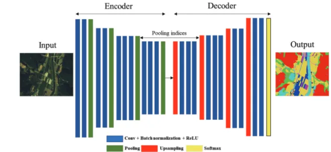
Fig. 2. SegNet Architecture in introduced by Badrinarayanan et al., 2015.
Fig. 1. Comparison of semantic segmentation, classification and localization, object detection and instance segmentation (Li et al., 2017; Rieder and Verbeet, 2019).
으로 , 학습의 효율성 및 정확도에서 높은 성능을 나타 내고 있다 (Badrinarayanan et al., 2017; Garcia-Garcia et al., 2017). SegNet 모델의 아키텍쳐는 인코더 및 디코더 프 로세스로 구성된다 . 인코더 프로세스에서 압축 및 특징 추출단계가 진행되며 , 디코더 프로세스에서 영상 복원 을 진행한다 . SegNet은 기존 Pooling layer를 디코더 프로 세스에 활용함으로써 공간정보 소실의 문제점을 해결 하였다 (Badrinarayanan et al., 2017).
SegNet을 토지피복에 적용한 연구를 살펴보면, FCN 또는 FCN계열의유명한알고리즘인U-Net(Ronneberger
et al., 2015)보다 농지와 같은 식생에서 낮은 성능이 나타났다(Han et al., 2020; Li et al., 2020). SegNet과 U-net을 비 교한 다른 연구는 주거지역과 건물, 과수원, 발굴된 땅 에서 U-net에 비해 높은 성능이 나타난 것을 확인하였 다 (Ning et al., 2020). 특히 SegNet이 분류해낸 항목을 살 펴보면 , 나무와 같은 식생항목에 비해 도로, 건물, 자동 차와 같은 항목들의 정확도가 높게 산정되며 , 특히 건 물항목에서 높은 성능을 보여주고 있다 (Audebert et al., 2018; Lee et al., 2020; Kendall et al., 2016).
3) U-Net
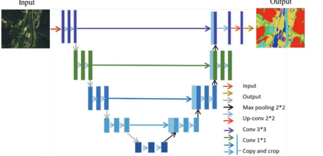
U-net은 Ronneberger et al. (2015)가 제안한 모델로 적 은 수의 의료 이미지 Segmentation에서 주로 적용되었 으며 , 모델의 구조가 알파벳 U와 유사한 구조를 가지고 있다 (Liu et al., 2019). 모델의 Architecture를 살펴보면 크
게 왼쪽은 contracting path, 오른쪽은 expansive path로 나뉜다 . contracting path 단계에서는 NxNxC 크기의 C 채널을 갖는 이미지 패치를 입력 레이어로 사용한다 . 각 단계별로 Convolution layer, ReLU 활성함수 및 Max pooling을 이용한 sub-sampling을 시행한다. Expansive path 단계에서 U-net은 두가지 특징이 나타난다. 첫번째 는 skip connection 사용하여 contracting path단계에서 사용된 원시정보를 가져오는 copy and crop 과정이다 (Stoian et al., 2019). 두번째는 영상복원 단계에서 Fully connected layer 없이 convolution layer만 존재한다. network 에서는 input image를 미러링하여 패치의 경계 값을 예측 한다(Soni et al., 2019). U-net의 경우 기존의 sliding window 가 아닌 patch 단위로 input data를 사용함으로써, 기존 네트워크가 가진 느린 속도를 개선했다 . Copy and crop 을 이용한 concat을 통해 이미지의 context를 정확하게 포착하며 , FCN이 가지고 있는 localization 문제를 해결 하였다 (Ronneberger et al., 2015).
4) DeepLabV3+
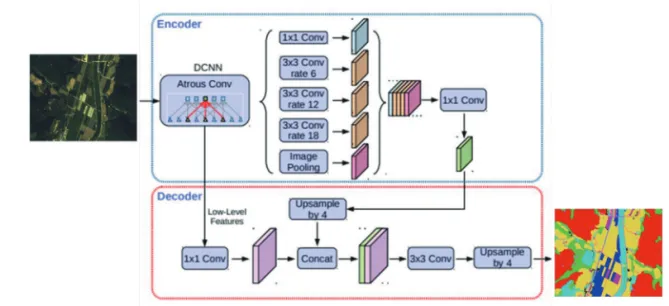
DeeplabV3+ 모델은 인코딩과 디코딩 구조로 나뉜다 (Peng et al., 2020). 먼저 인코더 과정에서 특징 추출 및 압 축이 진행되며 , DeeplabV3+는 convolution 중간에 공간 을 비워두는 Atrous convolution을 사용하여 특징 추출 을 진행하였다 . Atrous convolution은 pooling 과정에서 상세한 정보의 유실 및 특징의 추상화를 방지함으로 모
Fig. 3. U-Net architecure in introduced by Ronneberger et al. (2015).
델의 성능을 높일 수 있다 . 또한 pooling 과정에서 spatial pyramid pooling을 적용하여 다양한 크기의 정보를 담을 수 있게 구성하였다 (Chen et al., 2018). 특징 추출 완료 후, 디코더 과정에서 원본 이미지와 동일한 해상도로 영상 이 복원되며 , 최종 결과를 예측한다. 디코더 과정은 U- net과 유사하게 concat을 적용하여 영상을 복원하는 방 법을 사용한다 (Peng et al., 2020).
5) 연구지역
본 연구의 평가대상지역은 경상북도 봉화군 일대로 연구지역 선정을 위해 산림청 임상도 및 환경부 토지피 복지도를 기본자료로 사용하였다 . 경상북도는 산림 면
적이 19,031 km
2으로 넓은 산림면적을 가지고 있으며 , 산림 벌채로 인한 피복의 변화가 가장 큰 지역이다 (산 림청 , 2019). 본 연구지역은 대부분 산림 지역을 이루고 있어 모델의 토지피복 분류 시 , 상대적으로 적은 면적 을 차지하게 되는 도로 및 건물 등의 항목이 높은 성능 을 나타내는가에 대한 평가를 실행하기에 적합한 지역 으로 판단된다 .
6) 데이터셋 구축
정밀한 딥러닝 데이터셋 구축은 분류 항목의 정확한 분류를 보장하기 위해 필수적이다 . 본 연구에서 사용된 고해상도 영상은 Kompasat-3 위성영상으로 Pancromatic
Fig. 5. Study area of in this study.
Fig. 4. DeeplabV3+ architecture in introduced by Peng et al. (2018).
(PAN), blue, green, red, near infrared (NIR)의 5개 밴드 로 구성된다. 영상은 2015년, 2016년 그리고 2018년 7월 18일, 9월 8일, 10월 30일, 11월 20일 자료를 사용하였다.
전처리 과정으로는 Kompasat-3 영상은 정사보정 및 COST model (Chaves, 1996)을 통하여 대기보정을 시행 하였으며 , 고해상도의 다중분광 영상을 사용하기 위하 여 고해상도 PAN 영상을 상대적으로 낮은 다중분광 영 상에 적용하는 Pan-sharpening을 활용하였다(Zhang and Mishra, 2012). 결과적으로 4개 밴드의 0.7 m 해상도 다 중분광 영상을 본 연구에 활용하였다.
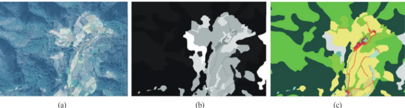
전처리과정 이후, Semantic segmentation모델에 적용 하기 위한 딥러닝 데이터셋을 구축 하였다 . 데이터셋은 원본영상 및 원본영상과 동일한 지역 및 크기의 ground truth 데이터로 구성된다. 정밀한 ground truth 데이터 구 축을 위해 임상도 및 토지피복지도를 기본 자료로 활용 하였으며 , 국토지리정보원의 수치지형도를 참고자료 로 사용하였다 .
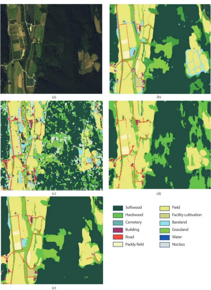
토지피복 항목은 산림지와 비산림지로 1차 분류 수 행 후, 각각을 세분화하여 도로 및 건물을 포함한 총 13 개의 항목으로 분류하였다 (Table 1). 학습 데이터셋은 검수 시 95% 이상의 정확도를 확보하였으며, 이보다 낮 을 경우 재수정을 실시하였다 . 데이터셋은 Kompasat-3 영상을 활용한 이미지 와 동일한 지역의 ground truth 데 이터로 구성하였으며 , 두 데이터 모두 Geotiff 형식으로 구축하였다 . 데이터는 학습용 및 테스트용 데이터셋으 로 구분 지었으며, 학습용 데이터는 모델 학습 및 검증, 테스트 데이터는 최종 성능 평가에 사용하였다. 테스트 지역의 항목 별 픽셀 갯수는 침엽수 675,816, 활엽수 136,352, 묘지 5,427, 건물 8,249, 도로 28,982, 논 19,613, 밭 427,740. 시설재배지 11,761, 나지 32,022, 초지 191,132, 그리고 수역 3,911 이며, 분류를 위한 영상을 제외한 나 머지 영상은 학습 및 검증에 사용되었으며 총 175장의 데이터셋이 훈련 및 검증에 사용되었다 .
Table 1. Classification item and color index
Class num. Class Color
10
Forest area
Softwood
20 Hardwood
30 Other forest
40 Cemetery
50 Dead tree
110
Non-forest area
Building
120 Road
130 Paddy field
140 Field
150 Facility cultivation
160 Bareland
170 Grassland
180 Water
(a) (b) (c)
Fig. 6. Example of dataset. (a) is image, (b) is grayscale ground truth, and (c) is colored ground truth.7) Hyper-parameter tuning
구축된 데이터셋을 활용하여, Semantic segmentation 모델 학습을 진행하며 , Semantic segmentation 모델이 최 적의 성능을 내는 hyper-parameter tuning을 실행하였다.
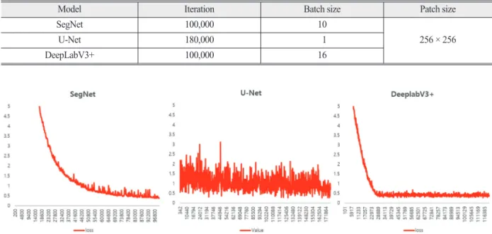
Hyper-parameter는 컴퓨터가 아닌 사용자가 직접 설정 하는 parameter로 모델의 최적화를 위한 필수적인 부분 이다 (Bardenet et al., 2013). 본 연구에서는 학습 반복횟수 (Iteration), 입력하는 영상의 크기를 의미하는 Patch size, 한번 학습 시 사용되는 영상의 개수를 의미하는 batch size등을 고려하였다. Hyper-paremeter는 학습, 검증 정 확도 및 손실 값 (loss)를 통하여 최적 hyper-parameter를 산출하였다 .
3. 연구결과 및 토의
1) Hyper-parameter tuning result
구축된 데이터셋을 SegNet, U-net 및 DeeplabV3+ 모 델에 적용하여 hyper-parameter 최적화 작업을 진행하였 으며, 그 결과는 Table 2와 같다. 학습반복횟수는 100,000 회 학습을 진행하면서 손실 값이 떨어지지 않을 경우 20,000회씩 추가 학습을 진행하였으며, 그 결과 SegNet 과 DeeplabV3+는 100,000회에서, U-Net은 180,000 가장
높은 정확도 및 낮은 손실 값을 산출하였다 . Patch size 는 컴퓨터 성능을 고려하여 세 모델 모두 256×256으로 고정하였다 . Batch size는 모델의 성능 및 컴퓨터 성능 을 고려하여 SegNet은 10, U-Net은 1, DeeplabV3+는 16 에서 가장 높은 분류 정확도 및 낮은 손실 값을 나타내 었다 . 본 연구에서 산출된 hyper-parameter를 적용하여 최종 분류를 진행하였다.
2) 분류결과
최적화된 hyper-parameter를 사용하여 SegNet모델 최 종 학습 진행 후, 본 연구의 연구대상지역에 테스트 데 이터를 통한 정확도 및 성능 평가를 진행하였다. 정확도 는 픽셀 정확도를 기준으로 산출하였으며, 최종 분류 정 확도는 SegNet 61.8%, U-Net 71.7% 그리고 DeeplabV3+
모델이 81.8%로 세 모델 중 가장 높은 정확도가 산정되 었으며 , 분류 결과는 Fig. 7과 같다.
먼저 SegNet의 결과를 살펴보면 분류 항목 중, 가장 많은 면적을 차지하는 침엽수의 경우 77.4%로 모든 항 목 중 가장 높은 정확도를 산출하였다 . 두번째로 많은 면적을 차지하는 활엽수의 경우 , 침엽수 항목과 오분류 가 많이 일어나 , 많은 면적을 차지함에도 35%의 낮은 분류 정확도를 나타내었다. 비산림지 중 가장 많은 면 적을 차지하는 밭의 경우 64.1%로 나타났으며, 도로의 경우, 상대적으로 적은 면적을 차지함에도 74.2%의 높
Fig. 7. training loss value of three deep learning algorithm.
Table 2. Hyper-parameter tuning result
Model Iteration Batch size Patch size
SegNet 100,000 10
256 × 256
U-Net 180,000 1
DeepLabV3+ 100,000 16
Fig. 8. Classification result. (a) is Kompast image, (b) is ground truth, (c) is SegNet result, (d) is U-Net result, and (e) is DeeplabV3+ result.
(a) (b)
(c) (d)
Softwood Hardwood Cemetery Building Road Paddy field
Field
Facility cultivation Bareland Grassland Water Noclass
(e)
은 분류 정확도를 산출하였다 . 면적이 적은 건물의 경우, 나지와의 오분류는 일어나지 않았으나 , 도로와의 혼동 으로 51.6%의 낮은 정확도를 산출하였다. 도로 및 건물 을 제외한 나머지 항목에서는 적은 면적을 차지함에 따 라 모두 50% 이하의 낮은 정확도를 산출하였다.
U-Net의 분류 항목별 정확도를 살펴보면, SegNet과 동일하게 가장 많은 면적을 차지하는 침엽수 항목에서 가장 높은 87.4%의 정확도가 산출되었다. 두번째로 높 은 정확도를 나타내는 항목은 밭 항목으로 84.9%의 정 확도를 산출하였다. U-Net은 세 모델과 비교하여, 활엽 수 항목에서 68.8%의 정확도로 가장 높은 정확도가 산
출되었다 . 다른 두 모델은 활엽수 항목에서 모두 50%이 하의 낮은 분류 정확도를 나타내었다 . 또한 밭 이외에 논의 경우도 69.7%로 다른 모델에 비해 높은 정확도를 산출하였지만 , 초지나 묘지, 도로 그리고 시설재배지의 항목에서 두 모델보다 모두 낮은 정확도를 산출하였다 . DeeplabV3+의 분류 정확도는 다른 세 모델에 비해 우수하게 나타났지만 , 일부 항목에서 차이를 보였다. 다 른 모델과 마찬가지로 가장 많은 면적을 차지하는 침엽 수의 경우, 97.5%로 가장 높은 정확도를 산출하였다.
U-Net과 동일하게, 두번째로 높은 정확도를 나타내는 항목은 밭 항목으로, U-Net의 정확도보다 약 10% 이상
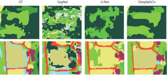
Fig. 9. Classification result of road and building area.GT SegNet U-Net DeeplabV3+
Fig. 10. Classification result of hardwood areas.
GT SegNet U-Net DeeplabV3+
의 높은 정확도를 나타내었다 . 세번째로 높은 정확도를 보인 항목은 시설재배지 항목으로 , 세 모델 중 70%이상 의 정확도를 보인 유일한 모델이다. 그러나 활엽수, 건 물의 항목에서는 SegNet, U-Net 모델보다 부족한 정확 도를 나타내었다 . 상세한 정확도는 Table 3과 같다.
전체적으로 DeeplabV3+는 가장 높은 정확도를 산출 하였지만 , 토지피복 항목에 따라 SegNet 및 U-Net 모델 이 우수한 경우도 존재하였다 . 항목별로 살펴보면, 침엽 수 항목의 경우 , 세가지 알고리즘 모두 높은 정확도를 보였으나, DeeplabV3+가 그 중에서 가장 높은 정확도를 보였다 . 그러나 침엽수와 유사한 활엽수 항목의 경우,
DeeplabV3+ 알고리즘보다 U-Net에서 더 높은 성능이 나타났다. 두 가지를 보았을 때, 침엽수와 활엽수의 구 분에는 U-Net이 더 적합한 알고리즘으로 보인다. 기타 산림, 묘지 그리고 고사목은 분류 면적이 거의 존재하지 않은 항목으로 낮은 분류 정확도를 나타냈다 . 건물과 도 로의 경우 , SegNet 알고리즘이 가장 높은 분류 정확도를 나타내었다. 이 결과는 SegNet 알고리즘이 주거지역 및 건물 등에서 높은 정확도 및 식생에서 낮은 정확도를 나 타낸 이전의 연구와 유사한 결과로 나타났다(Ning et al., 2020; Li et al., 2020). 논의 경우 U-Net과 DeeplabV3+ 알 고리즘이 유사한 정확도를 산출하였지만 U-Net의 정확 도가 더 높게 산출되었으며, 밭의 경우, DeeplabV3+에 서 더 높은 정확도를 산출하였다 . 시설재배지 및 초지 항목은 DeeplabV3+에서 가장 높은 성능을 나타내었다.
수역의 경우 분류 지역의 수역면적이 적은 원인으로 세 알고리즘 모두 낮은 정확도를 보였다 .
4. 결론 및 제언
본 연구에서는 고해상도 위성영상을 활용한 토지피 복 구축 연구를 보다 효율적으로 진행하기 위하여 딥러 닝을 적용하는 방안을 연구하였다 . 기존의 토지피복 분 류 연구는 단일 방법론에 위성영상을 적용하여 대, 중, 세 분류 형태로 피복분류를 다양하게 추출하는 것이 중
Fig. 11. Classification result of facility cultivation and grassland.GT SegNet U-Net DeeplabV3+
Table 3. Accuracy of each classes
Class SegNet U-Net DeeplabV3+
Softwood 77.4 87.4 97.5
Hardwood 35.0 68.8 24.9
Other forest 0.0 0.0 0.0
Cemetery 17.4 0.0 8.6
Dead tree 0.0 0.0 0.0
Building 51.6 42.9 31.7
Road 74.2 63.3 68.8
Paddy field 0.0 69.7 66.4
Field 64.1 84.9 94.0
Facility cultivation 38.7 0.0 75.3
Bareland 13.8 0.6 30.3
Grassland 41.8 17.7 57.0
Water 0.0 2.5 6.8
점이었다면 , 본 연구에서는 다양한 딥러닝 알고리즘을 적용하여 토지피복 분류 항목에 접합한 알고리즘을 선 정하고 , 향후 이를 확대하기 위한 연구이다. 이를 통하 여 단일 방법론에 의존한 토지피복 분류 방식을 개선하 고자 하였다 .
연구결과를 위해 , FCN 계열의 딥러닝 알고리즘에 적 용 및 결과를 산출하고 , 알고리즘들의 토지피복 항목별 정확도를 평가 하였다 . 전체정확도는 SegNet, U-Net, DeeplabV3+모델별로 산출하였으며, DeeplabV3+ 모델 이 81.7%로 가장 높게 산정되었다. 그러나 결과를 항목 별로 나누게 되면, 항목에 따라 높은 성능을 내는 알고 리즘에 차이가 존재하였다. 도로 및 건물에서는 SegNet 이 가장 높은 성능을 나타내었으며, U-Net은 논과 활엽 수의 항목에서, DeeplabV3+는 밭, 시설재배지, 초지의 항목에서 높은 성능을 나타냈다 .
이러한 결과는 초기 FCN 계열의 망을 선정하는 과정 에 고려된 사항이다 . SegNet은 기본적으로 자율주행 차 량에 필요한 도로와 건물의 분류를 빠르게 진행하기 위 하여 설계된 딥러닝 알고리즘이며 , U-Net 등은 객체의 외각 경계보다는 속성이 유사한 사항을 추출하는데 유 리한 형식으로 설계되어 있다 . 그렇기 때문에 논 및 활 엽수 등 유사한 토지피복 항목 분류에 정확도가 높았다 . 이에 비하여 DeeplabV3+의 경우 최근 발표된 알고리즘 으로 다른 두 알고리즘보다 면적이 많이 차지하는 항목 , 시설재배지와 같은 항목 및 외각경계에 높은 성능을 보 였다 .
이 결과는 항목별로 높은 성능을 나타내는 알고리즘 에 차이가 존재하는 것으로 보이며, 하나의 알고리즘만 사용하는 것에 대한 한계점으로 예상된다. 세가지 알고 리즘 모두 넓은 면적을 차지하는 항목에서는 높은 성능 을 나타내었으며, 이는 데이터셋의 면적이 정확도에 영 향을 미치는 것으로 사료된다 . 향후 토지피복 항목별로 가장 높은 성능을 보이는 알고리즘을 개별적으로 적용 한다면 , 고품질의 토지피복 분류 결과를 산출할 수 있 을 것으로 기대된다 .
고해상도 위성영상을 활용한 토지피복 분류는 윈격 탐사 연구에서 기반이 되는 주요연구이다 . 이를 보다 정 밀하고 , 효율적으로 분류하기 위하여 분류 항목별 알고 리즘 최적화는 도출하는 것은 향후 , 지속적인 토지피복 분류 연구에 활용될 수 있을 것이다 . 그러나 본 연구는
몇가지 한계를 가지고 있다 . 첫째, 산림 분야를 중심으 로 딥러링 학습 데이터 셋을 구축하였다 . 그렇기 때문 에 연구 결과에서 면적인 가장 큰 지역이 침엽수 , 활엽 수 등이 분류되었다 . 둘째, 보다 다양한 알고리즘 적용 을 수행하지 못하였다 . 이는 딥러닝을 구현하는 물리적 하드웨어 환경의 영향으로 , 분석 장비를 보다 강화한다 면 동일 데이터 셋을 활용한 다양한 알고리즘 적용이 가 능 할 것으로 사료된다 .
사사
본 논문은 한국환경정책·평가연구원에서 수행한 한 국항공우주연구원(KARI)의 ‘위성영상과 머신 러닝을 활용한 산림변화 정밀 분석기술 개발’ 및 한국연구재단 의 이공학 개인기초연구(NRF-2018R1D1A1B07041203) 에 의해 수행되었습니다.
References
Akhtar, N. and A. Mian, 2018. Threat of adversarial attacks on deep learning in computer vision: A survey, IEEE Access, 6: 14410-14430.
Andersson, V., 2017. Semantic Segmentation: Using Convolutional Neural Networks and Sparse dictionaries Overview, https://www.diva-portal.
org/smash/record.jsf?pid=diva2%3A1127291&
dswid=-8672, Accessed on Aug. 14, 2020.
Arief, H. A., G. Strand, H. Tveite, and U. G. Indahl, 2018.
Land cover segmentation of airborne LiDAR data using stochastic atrous network, Remote Sensing, 10(6): 973.
Audebert, N., B. Le Saux, and S. Lefèvre, 2018. Beyond RGB: Very high resolution urban remote sensing with multimodal deep networks, ISPRS Journal
of Photogrammetry and Remote Sensing, 140:20-32.
Badrinarayanan, V., A. Handa, and R. Cipolla, 2017.
Segnet: A deep convolutional encoder-decoder
architecture for image segmentation, IEEE
Transactions on Pattern Analysis and Machine Intelligence, 39(12): 2481-2495.Bardenet, R., M. Brendel, B. Kégl, and M. Sebag, 2013.
Collaborative hyperparameter tuning, Proc. of
2013 International Conference on Machine Learning, Atlanta, USA, Jun. 16-21, pp. 199-207.Bhosle, K. and V. Musande, 2019. Evaluation of deep learning CNN model for land use land cover classification and crop identification using hyperspectral remote sensing images, Journal of
the Indian Society of Remote Sensing, 47(11):1949-1958.
Cao, R. and G. Qiu, 2018. Urban land use classification based on aerial and ground images, Proc. of
2018 International Conference on Content-Based Multimedia Indexing (CBMI), La Rochelle, FRA,Sep. 4-6, pp. 1-6.
Chavez, P. S., 1996. Image-based atmospheric corrections- revisited and improved, Photogrammetric Engineering
and Remote Sensing, 62(9): 1025-1035.Chen, L., Y. Zhu, G. Papandreou, F. Schroff, and H. Adam, 2018. Encoder-decoder with atrous separable convolution for semantic image segmentation,
Proc. of the European conference on computer vision (ECCV), Munich, GER, Sep. 8-14, pp.801-818.
Chen, Y., D. Ming, and X. Lv, 2019. Superpixel based land cover classification of VHR satellite image combining multi-scale CNN and scale parameter estimation, Earth Science Informatics, 12(3):
341-363.
Foody, G. M., 2002. Status of land cover classification accuracy assessment, Remote Sensing of Environment, 80(1): 185-201.
Gaetano, R., D. Ienco, K. Ose, and R. Cresson, 2018.
A two-branch CNN architecture for land cover classification of PAN and MS imagery, Remote
Sensing, 10(11): 1746.Garcia-Garcia, A., S. Orts-Escolano, S. Oprea, V. Villena-
Martinez, and J. Garcia-Rodriguez, 2017. A review on deep learning techniques applied to semantic segmentation, Arxiv preprint, 1704.06857 (v1): 1-23.
Kampffmeyer, M., A. Salberg, and R. Jenssen, 2016.
Semantic segmentation of small objects and modeling of uncertainty in urban remote sensing images using deep convolutional neural networks,
Proc. of the 2016 IEEE conference on computer vision and pattern recognition workshops, LasVegas, NV, Jun. 27-30, pp. 1-9.
Kemker, R., C. Salvaggio, and C. Kanan, 2018. Algorithms for semantic segmentation of multispectral remote sensing imagery using deep learning,
ISPRS Journal of Photogrammetry and Remote Sensing, 145: 60-77.Kendall, A., V. Badrinarayanan, and R. Cipolla, 2015.
Bayesian segnet: Model uncertainty in deep convolutional encoder-decoder architectures for scene understanding, Arxiv preprint, 1511.02680 (v2): 1-11.
Korea Forest Service Home Page Overview, http://
forest.go.kr, Accessed on Feb. 30, 2019.
Kussul, N., M. Lavreniuk, S. Skakun, and A. Shelestov, 2017. Deep learning classification of land cover and crop types using remote sensing data, IEEE
Geoscience and Remote Sensing Letters, 14(5):778-782.
LeCun, Y., Y. Bengio, and G. Hinton, 2015. Deep learning, Nature, 521(7553): 436-444.
Lee, D. G., Y. H. Shin, and D. Lee, 2020. Land Cover Classification Using SegNet with Slope, Aspect, and Multidirectional Shaded Relief Images Derived from Digital Surface Model, Journal of Sensors, 2020: 1-21.
Li, F., J. Johnson, and S. Yeung, 2017. Convolutional neural networks for visual recognition lecture notes Overview, https://sites.google.com/site/
aidysft/lecturenotes, Accessed on Jun. 13, 2020.
Liu, S., L. Qi, H. Qin, J. Shi, and J. Jia, 2018. Path
aggregation network for instance segmentation,
Proc. of the 2018 IEEE conference on computer vision and pattern recognition, Salt Lake City,UT, Jun. 19-21, pp. 8759-8768.
Long, J., E. Shelhamer, and T. Darrell, 2015. Fully convolutional networks for semantic segmentation,
Proc. of the 2015 IEEE conference on computer vision and pattern recognition, Boston, MA,Jun. 7-12, pp. 3431-3440.
Ma, L., M. Li, X. Ma, L. Cheng, P. Du, and Y. Liu, 2017. A review of supervised object-based land- cover image classification, ISPRS Journal of
Photogrammetry and Remote Sensing, 130:277-293.
Mao, Q., H. Sun, Y. Liu, and R. Jia, 2019. Mini-YOLOv3:
real-time object detector for embedded applications,
IEEE Access, 7: 133529-133538.Ning, H., Z. Li, C. Wang, and L. Yang, 2020. Choosing an appropriate training set size when using existing data to train neural networks for land cover segmentation, Annals of GIS, 2020: 1-14.
Paisitkriangkrai, S., J. Sherrah, P. Janney, and V. Hengel, 2015. Effective semantic pixel labelling with convolutional networks and conditional random fields, Proc. of the IEEE Conference on Computer
Vision and Pattern Recognition Workshops, Boston,MA, Jun. 7-12, pp. 36-43.
Papadomanolaki, M., M. Vakalopoulou, and K. Karantzalos, 2019. A novel object-based deep learning framework for semantic segmentation of very high-resolution remote sensing data: Comparison with convolutional and fully convolutional networks, Remote Sensing, 11(6): 684.
Peng, H., C. Xue, Y. Shao, K. Chen, J. Xiong, Z. Xie, and L. Zhang, 2020. Semantic Segmentation of Litchi Branches Using DeepLabV3 Model, IEEE
Access, 8: 164546-164555.Rana, V. K. and T. M. V. Suryanarayana, 2020.
Performance evaluation of MLE, RF and SVM classification algorithms for watershed scale land
use/land cover mapping using sentinel 2 bands,
Remote Sensing Applications: Society and Environment, 19: 100351.Rieder, M. and R. Verbeet, 2019. Robot-human-learning for robotic picking processes, Artificial Intelligence and Digital Transformation in Supply Chain Management: Innovative Approaches for Supply Chains, Proc. of 2019 Hamburg International
Conference of Logistics (HICL), Hamburg, GER,Sep. 25-27, vol. 27, pp. 87-114.
Rodriguez-Galiano, V. F., B. Ghimire, J. Rogan, M.
Chica-Olmo, and J. P. Rigol-Sanchez, 2012. An assessment of the effectiveness of a random forest classifier for land-cover classification,
ISPRS Journal of Photogrammetry and Remote Sensing, 67: 93-104.Ronneberger, O., P. Fischer, and T. Brox, 2015. U-net:
Convolutional networks for biomedical image segmentation, Proc. of 2015 International
Conference on Medical image computing and computer-assisted intervention, Munich, GER,Oct. 5-9 pp. 234-241.
Soni, A., R. Koner, and V. G. K. Villuri, 2020. M-UNet:
Modified U-Net Segmentation Framework with Satellite Imagery, Proc. of the Global AI Congress
2019, Kolkata, IND, Sep. 12-14, pp. 47-59.Stoian, A., V. Poulain, J. Inglada, V. Poughon, and D.
Derksen, 2019. Land cover maps production with high resolution satellite image time series and convolutional neural networks: Adaptations and limits for operational systems, Remote Sensing, 11(17): 1986.
Volpi, M. and V. Ferrari, 2015. Semantic segmentation of urban scenes by learning local class interactions,
Proc. of the IEEE Conference on Computer Vision and Pattern Recognition Workshops, Boston, MA,Jun. 7-12, pp. 1-9.
Voulodimos, A., N. Doulamis, A. Doulamis, and E.
Protopapadakis, 2018. Deep learning for Computer
vision: A brief review, Computational intelligence
and neuroscience, 2018: 1-14.