1. Introduction
An M
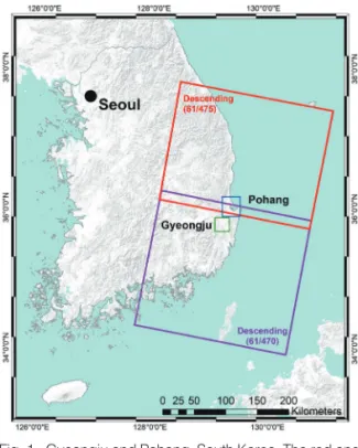
L5.8 earthquake shocked Gyeongju at 11:32:55 UTC on September 12, 2016. The epicenter was 8.7 km from the south of the city and 15 km beneath the surface (Kim et al., 2016). One year later on November 15, 2017, an M
L5.4 earthquake occurred in Pohang, South Korea at 05:29:31 UTC, causing widespread
damage in and around the city (Kang et al., 2019).
The Pohang earthquake was just 40 km from the Gyeongju earthquake. The depth of the mainshock was approximately 7.0 km, and several aftershocks were reported around the area (Kim et al., 2018). Both earthquakes were the largest to occur in the Korean Peninsula since earthquake monitoring was initiated by the Korea Meteorological Administration (KMA) in
Damage Proxy Map (DPM)
of the 2016 Gyeongju and 2017 Pohang Earthquakes Using Sentinel-1 Imagery
Arip Syaripudin Nur
1)· Chang-Wook Lee
2)†Abstract: The M
L5.8 earthquake shocked Gyeongju, Korea, at 11:32:55 UTC on September 12, 2016. One year later, on the afternoon of November 15, 2017, the M
L5.4 earthquake occurred in Pohang, South Korea. The earthquakes injured many residents, damaged buildings, and affected the economy of Gyeongju and Pohang.
The damage proxy maps (DPMs) were generated from Sentinel-1 synthetic aperture radar (SAR) imagery by comparing pre- and co-events interferometric coherences to identify anomalous changes that indicate damaged by the earthquakes. DPMs manage to detect coherence loss in residential and commercial areas in both Gyeongju and Pohang earthquakes. We found that our results show a good correlation with the Korea Meteorological Administration (KMA) report with Modified Mercalli Intensity (MMI) scale values of more than VII (seven).
The color scale of Sentinel-1 DPMs indicates an increasingly significant change in the area covered by the pixel, delineating collapsed walls and roofs from the official report. The resulting maps can be used to assess the distribution of seismic damage after the Gyeongju and Pohang earthquakes and can also be used as inventory data of damaged buildings to map seismic vulnerability using machine learning in Gyeongju or Pohang.
Key Words: Gyeongju earthquake, Pohang earthquake, Sentinel-1, Damage proxy map
https://doi.org/10.7780/kjrs.2021.37.1.2 ISSN 2287-9307 (Online)
Article
Received January 28, 2021; Revised February 6, 2021; Accepted February 9, 2021; Published online February 15, 2021
1)
Combined MS/PhD Student, Department of Smart Regional Innovation, Kangwon National University
2)
Professor, Division of Science Education, Kangwon National University
†